Hardwick

Settlement in Norfolk King's Lynn and West Norfolk

England

Hardwick

Priory and Parish church of St Margaret Dedicated as King's Lynn's Minster in 2011. Apparently one tower is for the local parish and community, and one tower is for the priory and monks.
Priory and Parish church of St Margaret Credit: Nigel Thompson

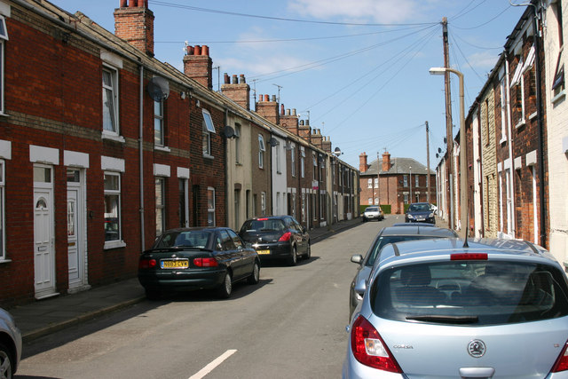
Hardwick is a small village located in the county of Norfolk, England. It is situated approximately 4 miles south of the market town of King's Lynn. The village is known for its picturesque countryside surroundings, with rolling fields and charming old cottages dotting the landscape.

Hardwick is home to a tight-knit community of around 500 residents. The village has a primary school, a church, and a village hall which serves as a hub for social gatherings and events.

The area surrounding Hardwick is predominantly agricultural, with many residents working in farming or related industries. The village is well-connected by road, with easy access to the A47 which links it to nearby towns and cities.

Despite its small size, Hardwick offers a peaceful and idyllic setting for those looking to escape the hustle and bustle of urban life. The village is a popular destination for walkers and nature enthusiasts, with many scenic footpaths and bridleways crisscrossing the surrounding countryside. Overall, Hardwick is a quintessentially English village with a strong sense of community and a rich rural heritage.

If you have any feedback on the listing, please let us know in the comments section below.

Hardwick Images

Images are sourced within 2km of 52.740579/0.41097904 or Grid Reference TF6218. Thanks to Geograph Open Source API. All images are credited.

Priory and Parish church of St Margaret Dedicated as King's Lynn's Minster in 2011. Apparently one tower is for the local parish and community, and one tower is for the priory and monks.
Priory and Parish church of St Margaret
Dedicated as King's Lynn's Minster in 2011. Apparently one tower is for the local parish and community, and one tower is for the priory and monks.
Purfleet Quay and Custom House, King's Lynn The Custom House was designed by Henry Bell and built in 1683.
Purfleet Quay and Custom House, King's Lynn
The Custom House was designed by Henry Bell and built in 1683.
Guannock Gate and town wall, King's Lynn
King's Lynn Minster The parish church of St Margaret was elevated to become King's Lynn Minster <span class="nowrap"><a title="https://kingslynnminster.org/" rel="nofollow ugc noopener" href="https://kingslynnminster.org/">Link</a><img style="margin-left:2px;" alt="External link" title="External link - shift click to open in new window" src="https://s1.geograph.org.uk/img/external.png" width="10" height="10"/></span> in 2011, one of a wave of churches which gained Minster status around that time.  

On the right can be seen Hanse House <span class="nowrap"><a title="http://www.hansehouse.co.uk/history/" rel="nofollow ugc noopener" href="http://www.hansehouse.co.uk/history/">Link</a><img style="margin-left:2px;" alt="External link" title="External link - shift click to open in new window" src="https://s1.geograph.org.uk/img/external.png" width="10" height="10"/></span> ; this incorporates a mediaeval warehouse once owned by the Hanseatic League, which used the town as a trading post. Today the building has a variety of uses, including offices, an indoor market, three flats, function rooms and a wine bar <span class="nowrap"><a title="https://www.therathskeller.co.uk/" rel="nofollow ugc noopener" href="https://www.therathskeller.co.uk/">Link</a><img style="margin-left:2px;" alt="External link" title="External link - shift click to open in new window" src="https://s1.geograph.org.uk/img/external.png" width="10" height="10"/></span> .
King's Lynn Minster
The parish church of St Margaret was elevated to become King's Lynn Minster LinkExternal link in 2011, one of a wave of churches which gained Minster status around that time. On the right can be seen Hanse House LinkExternal link ; this incorporates a mediaeval warehouse once owned by the Hanseatic League, which used the town as a trading post. Today the building has a variety of uses, including offices, an indoor market, three flats, function rooms and a wine bar LinkExternal link .
Customs House in 1990 View from the west along Purfleet Quay
Customs House in 1990
View from the west along Purfleet Quay
Millfleet Burial Ground A small brick enclosure used for the burial of a community of Dutch Jews who lived in Lynn from the mid eighteenth to the mid nineteenth centuries. The walls of the enclosure, however, date from the sixteenth century <span class="nowrap"><a title="https://historicengland.org.uk/listing/the-list/list-entry/1298159?section=official-list-entry" rel="nofollow ugc noopener" href="https://historicengland.org.uk/listing/the-list/list-entry/1298159?section=official-list-entry">Link</a><img style="margin-left:2px;" alt="External link" title="External link - shift click to open in new window" src="https://s1.geograph.org.uk/img/external.png" width="10" height="10"/></span>
Millfleet Burial Ground
A small brick enclosure used for the burial of a community of Dutch Jews who lived in Lynn from the mid eighteenth to the mid nineteenth centuries. The walls of the enclosure, however, date from the sixteenth century LinkExternal link
King's Lynn Railway Station Built for the Great Eastern Railway 1871-2 <span class="nowrap"><a title="https://historicengland.org.uk/listing/the-list/list-entry/1389399?section=official-list-entry" rel="nofollow ugc noopener" href="https://historicengland.org.uk/listing/the-list/list-entry/1389399?section=official-list-entry">Link</a><img style="margin-left:2px;" alt="External link" title="External link - shift click to open in new window" src="https://s1.geograph.org.uk/img/external.png" width="10" height="10"/></span>
King's Lynn Railway Station
Built for the Great Eastern Railway 1871-2 LinkExternal link
Red Mount Chapel, King's Lynn Late fifteenth century Pilgrimage Chapel <span class="nowrap"><a title="https://historicengland.org.uk/listing/the-list/list-entry/1195403?section=official-list-entry" rel="nofollow ugc noopener" href="https://historicengland.org.uk/listing/the-list/list-entry/1195403?section=official-list-entry">Link</a><img style="margin-left:2px;" alt="External link" title="External link - shift click to open in new window" src="https://s1.geograph.org.uk/img/external.png" width="10" height="10"/></span>
Red Mount Chapel, King's Lynn
Late fifteenth century Pilgrimage Chapel LinkExternal link
The Gaywood River, King's Lynn Looking from St. John's Walk towards the culvert beneath the railway.
The Gaywood River, King's Lynn
Looking from St. John's Walk towards the culvert beneath the railway.
Mayor's Avenue, The Walks, King's Lynn Follows the line of the town walls.
Mayor's Avenue, The Walks, King's Lynn
Follows the line of the town walls.
North Guannock Gate and parts of the town wall The originals dated from the thirteenth century but much of what remains dates from the early nineteenth century
North Guannock Gate and parts of the town wall
The originals dated from the thirteenth century but much of what remains dates from the early nineteenth century
Greyfriars Tower The tower stood at the crossing of the church of the Greyfriars (Franciscans) church <span class="nowrap"><a title="https://historicengland.org.uk/listing/the-list/list-entry/1195428?section=official-list-entry" rel="nofollow ugc noopener" href="https://historicengland.org.uk/listing/the-list/list-entry/1195428?section=official-list-entry">Link</a><img style="margin-left:2px;" alt="External link" title="External link - shift click to open in new window" src="https://s1.geograph.org.uk/img/external.png" width="10" height="10"/></span>
Greyfriars Tower
The tower stood at the crossing of the church of the Greyfriars (Franciscans) church LinkExternal link
Tower Gardens, King's Lynn
Arches in Tower Gardens, King's Lynn Resited from a house near Tuesday Market <span class="nowrap"><a title="https://historicengland.org.uk/listing/the-list/list-entry/1290265?section=official-list-entry" rel="nofollow ugc noopener" href="https://historicengland.org.uk/listing/the-list/list-entry/1290265?section=official-list-entry">Link</a><img style="margin-left:2px;" alt="External link" title="External link - shift click to open in new window" src="https://s1.geograph.org.uk/img/external.png" width="10" height="10"/></span>
Arches in Tower Gardens, King's Lynn
Resited from a house near Tuesday Market LinkExternal link
County Court, King's Lynn Dates from 1861 <span class="nowrap"><a title="https://historicengland.org.uk/listing/the-list/list-entry/1210671?section=official-list-entry" rel="nofollow ugc noopener" href="https://historicengland.org.uk/listing/the-list/list-entry/1210671?section=official-list-entry">Link</a><img style="margin-left:2px;" alt="External link" title="External link - shift click to open in new window" src="https://s1.geograph.org.uk/img/external.png" width="10" height="10"/></span>
County Court, King's Lynn
Dates from 1861 LinkExternal link
Tyre depot, St. James Street, King's Lynn An early example of a concrete framed building dating from 1908 <span class="nowrap"><a title="https://historicengland.org.uk/listing/the-list/list-entry/1459413?section=official-list-entry" rel="nofollow ugc noopener" href="https://historicengland.org.uk/listing/the-list/list-entry/1459413?section=official-list-entry">Link</a><img style="margin-left:2px;" alt="External link" title="External link - shift click to open in new window" src="https://s1.geograph.org.uk/img/external.png" width="10" height="10"/></span>
Tyre depot, St. James Street, King's Lynn
An early example of a concrete framed building dating from 1908 LinkExternal link
Towergate Insurance Brokers A 'moderne' building of the 1930s.
Towergate Insurance Brokers
A 'moderne' building of the 1930s.
The Majestic Cinema, King's Lynn Built 1928. Designed by J.L Carnell and W.D. White <span class="nowrap"><a title="https://historicengland.org.uk/listing/the-list/list-entry/1271798?section=official-list-entry" rel="nofollow ugc noopener" href="https://historicengland.org.uk/listing/the-list/list-entry/1271798?section=official-list-entry">Link</a><img style="margin-left:2px;" alt="External link" title="External link - shift click to open in new window" src="https://s1.geograph.org.uk/img/external.png" width="10" height="10"/></span>
The Majestic Cinema, King's Lynn
Built 1928. Designed by J.L Carnell and W.D. White LinkExternal link
Show me another place!

Hardwick is located at Grid Ref: TF6218 (Lat: 52.740579, Lng: 0.41097904)

Administrative County: Norfolk

District: King's Lynn and West Norfolk

Police Authority: Norfolk

What 3 Words

///ritual.bonus.reader. Near King's Lynn, Norfolk

Nearby Locations

Hardwick

Related Wikis

King's Lynn F.C.

King's Lynn Football Club was an English association football club based in King's Lynn, Norfolk. The club was founded in 1881 and they were wound up at...

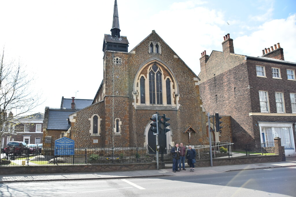
Our Lady of the Annunciation Church, King's Lynn

Our Lady of the Annunciation Church is a Roman Catholic parish church in King's Lynn, Norfolk, England. It was built in 1897, but incorporates parts of...

South Lynn

South Lynn is an area of King's Lynn, in the King's Lynn and West Norfolk district, in the county of Norfolk, England. It is located directly south of...

King's Lynn Town F.C.

King's Lynn Town Football Club is a football club based in King's Lynn, Norfolk, England. Nicknamed 'The Linnets', they are currently members of the National...

Nearby Amenities

Located within 500m of 52.740579,0.41097904
Motorway Junction
Hardwick Roundabout
Lat/Long: 52.7366648/0.4112712
Bus Stop
McDonalds layby, adj
Bus: yes
Naptan AtcoCode: 2900K13137
Naptan Bearing: NW
Naptan CommonName: McDonalds layby
Naptan Indicator: adj
Naptan Landmark: McDonalds Layby
Naptan Locality: King's Lynn
Naptan NaptanCode: nfodamgt
Naptan PlusbusZoneRef: KLYNN
Naptan Street: Hardwick Road
Naptan Verified: no
Public Transport: platform
Source: naptan_import
Lat/Long: 52.7403999/0.4098942
Turning Circle
Lat/Long: 52.7409832/0.4051226
Bus Stop
Paxman Road, opp
Bus: yes
Naptan AtcoCode: 2900K13162
Naptan Bearing: SE
Naptan CommonName: Paxman Road
Naptan Indicator: opp
Naptan Landmark: Paxman Road
Naptan Locality: King's Lynn
Naptan NaptanCode: nfodamwg
Naptan PlusbusZoneRef: KLYNN
Naptan Street: Hansa Road
Naptan Verified: no
Public Transport: platform
Source: naptan_import
Lat/Long: 52.7416675/0.410947
Bus Stop
Paxman Road, adj
Bus: yes
Naptan AtcoCode: 2900K13168
Naptan Bearing: NW
Naptan CommonName: Paxman Road
Naptan Indicator: adj
Naptan Landmark: Paxman Road
Naptan Locality: King's Lynn
Naptan NaptanCode: nfodapag
Naptan PlusbusZoneRef: KLYNN
Naptan Street: Hansa Road
Naptan Verified: no
Public Transport: platform
Source: naptan_import
Lat/Long: 52.7417564/0.4107587
Bus Stop
Industrial Estate, NW-bound
Bus: yes
Naptan AtcoCode: 2900K1337
Naptan Bearing: NW
Naptan CommonName: Industrial Estate
Naptan Indicator: NW-bound
Naptan Landmark: Tesco
Naptan Locality: King's Lynn
Naptan NaptanCode: nfodapga
Naptan Street: Hardwick Road
Naptan Verified: no
Public Transport: platform
Source: naptan_import
Lat/Long: 52.7392155/0.4132811
Bus Stop
Scania Way, opp
Bus: yes
Naptan AtcoCode: 2900K1349
Naptan Bearing: NE
Naptan BusStopType: CUS
Naptan CommonName: Scania Way
Naptan Indicator: opp
Naptan Landmark: Scania Way
Naptan Locality: King's Lynn
Naptan NaptanCode: nfodapjg
Naptan PlusbusZoneRef: KLYNN
Naptan Street: Oldmedow Road
Naptan Verified: no
Public Transport: platform
Source: naptan_import
Lat/Long: 52.7421312/0.4157577
Bus Stop
Industrial Estate, SE-bound
Bus: yes
Naptan AtcoCode: 2900K1358
Naptan Bearing: SE
Naptan CommonName: Industrial Estate
Naptan Indicator: SE-bound
Naptan Landmark: Homebase
Naptan Locality: King's Lynn
Naptan NaptanCode: nfodapmp
Naptan PlusbusZoneRef: KLYNN
Naptan Street: Hardwick Road
Naptan Verified: no
Public Transport: platform
Source: naptan_import
Lat/Long: 52.7397671/0.4122427
Bus Stop
Scania Way, adj
Bus: yes
Naptan AtcoCode: 2900K139
Naptan Bearing: SW
Naptan BusStopType: CUS
Naptan CommonName: Scania Way
Naptan Indicator: adj
Naptan Landmark: Scania Way
Naptan Locality: King's Lynn
Naptan NaptanCode: nfodatga
Naptan PlusbusZoneRef: KLYNN
Naptan Street: Oldmedow Road
Naptan Verified: no
Public Transport: platform
Source: naptan_import
Lat/Long: 52.7421464/0.4163363
Power: pole
Lat/Long: 52.7380402/0.4053053
Power: pole
Lat/Long: 52.7440491/0.4098872
Power: pole
Lat/Long: 52.7440312/0.4099676
Power: pole
Lat/Long: 52.7379968/0.4054632
Power: pole
Lat/Long: 52.743005/0.4089645
Power: pole
Lat/Long: 52.7430066/0.4090637
Power: pole
Lat/Long: 52.7430033/0.4088706
Power: pole
Lat/Long: 52.7440685/0.4098174
Power: pole
Lat/Long: 52.7380181/0.4053855
Mini Roundabout
Lat/Long: 52.7369181/0.4124332
Crossing
Lat/Long: 52.7403576/0.4093428
Bus Stop
Sainsburys, adj
Bus: yes
Naptan AtcoCode: 2900K1201
Naptan Bearing: NE
Naptan CommonName: Sainsburys
Naptan Indicator: adj
Naptan Locality: King's Lynn
Naptan NaptanCode: nfogtjdm
Naptan Street: Entrance
Naptan Verified: no
Public Transport: platform
Source: naptan_import
Lat/Long: 52.7387577/0.4177581
Crossing
Crossing: traffic_signals
Crossing Ref: toucan
Tactile Paving: yes
Lat/Long: 52.7380678/0.4154961
Bicycle Parking
Sainsbury's
Bicycle Parking: stands
Capacity: 24
Covered: yes
Operator: Sainsbury's
Lat/Long: 52.7389522/0.417618
Bicycle Parking
Sainsbury's
Bicycle Parking: stands
Capacity: 8
Covered: no
Operator: Sainsbury's
Lat/Long: 52.7393566/0.4178438
Crossing
Crossing: traffic_signals
Crossing Ref: pelican
Island: yes
Tactile Paving: yes
Lat/Long: 52.7382895/0.4155699
Crossing
Lat/Long: 52.7398499/0.4109453
Traffic Signals
Lat/Long: 52.7402658/0.4106821
Crossing
Lat/Long: 52.7393661/0.4089957
Crossing
Crossing: marked
Crossing Markings: zebra
Lat/Long: 52.7381679/0.4121585
Give Way
Lat/Long: 52.7379331/0.414727
Mini Roundabout
Direction: clockwise
Lat/Long: 52.7408136/0.4114844
Traffic Signals
Traffic Signals: pedestrian_crossing
Lat/Long: 52.738501/0.4156577
Waste Basket
Waste: trash
Lat/Long: 52.7375084/0.4156847
Give Way
Lat/Long: 52.7375601/0.4129606
Give Way
Lat/Long: 52.7425438/0.4111836
Crossing
Lat/Long: 52.740178/0.4109252
Give Way
Lat/Long: 52.7377714/0.4156657
Give Way
Lat/Long: 52.7377992/0.4154837
Give Way
Lat/Long: 52.7376752/0.4152756
Give Way
Lat/Long: 52.7376261/0.4155984
Give Way
Lat/Long: 52.7374813/0.4149013
Crossing
Crossing: uncontrolled
Crossing Ref: zebra
Lat/Long: 52.7375215/0.4122366
Crossing
Crossing: uncontrolled
Crossing Ref: zebra
Lat/Long: 52.7374861/0.4124568
Crossing
Crossing: uncontrolled
Crossing Ref: zebra
Lat/Long: 52.7374562/0.4126278
Give Way
Lat/Long: 52.7377108/0.4127568
Compressed Air
Lat/Long: 52.7378438/0.4138364
Vacuum Cleaner
Lat/Long: 52.7378099/0.4138284
Car Wash
Jet Wash
Covered: no
Self Service: yes
Lat/Long: 52.7379676/0.4136543
Give Way
Lat/Long: 52.7380699/0.4137624
Give Way
Lat/Long: 52.7377345/0.4134263
Crossing
Crossing: unmarked
Crossing Markings: no
Tactile Paving: yes
Lat/Long: 52.7379179/0.4134984
Crossing
Crossing: uncontrolled
Crossing Ref: zebra
Lat/Long: 52.7372949/0.4143141
Crossing
Crossing: uncontrolled
Crossing Ref: zebra
Lat/Long: 52.7374382/0.4142323
Power: substation
Lat/Long: 52.7377602/0.4122402
Crossing
Crossing: uncontrolled
Crossing Ref: zebra
Lat/Long: 52.7393313/0.4175268
Crossing
Crossing: marked
Crossing Markings: yes
Lat/Long: 52.740853/0.4097319
Crossing
Crossing: marked
Crossing Markings: yes
Lat/Long: 52.7409739/0.4098432
Crossing
Lat/Long: 52.7387924/0.4099844
Crossing
Crossing: marked
Crossing Markings: yes
Lat/Long: 52.7394588/0.4105997
Crossing
Lat/Long: 52.7390848/0.4086509
Post Box
Addr City: King's Lynn
Addr Street: Hansa Road
Collection Times: Mo-Fr 17:15; Sa 10:30; Su off
Operator: Royal Mail
Operator Wikidata: Q638098
Ref: PE30 451
Lat/Long: 52.7420286/0.4106454
Post Box
Addr City: King's Lynn
Addr Street: Hansa Road
Collection Times: Mo-Fr 17:15; Sa 10:30; Su off
Ref: PE30 509
Lat/Long: 52.7421164/0.4106969
Cafe
Costa
Addr City: King's Lynn
Addr Housename: Next
Addr Housenumber: 7-9
Addr Parentstreet: Hansa Road
Addr Place: Pierpoint Retail Park
Addr Postcode: PE30 4NA
Brand: Costa
Brand Wikidata: Q608845
Brand Wikipedia: en:Costa Coffee
Cuisine: coffee_shop
Fhrs Id: 1401618
Outdoor Seating: no
Source Addr: FHRS Open Data
Takeaway: yes
Lat/Long: 52.7400381/0.4121977
Crossing
Crossing: marked
Crossing Markings: yes
Lat/Long: 52.7387067/0.4126529
Crossing
Crossing: marked
Crossing Markings: yes
Lat/Long: 52.7387799/0.4124386
Crossing
Crossing: marked
Crossing Markings: yes
Lat/Long: 52.7388473/0.4122325
Crossing
Crossing: marked
Crossing Markings: yes
Lat/Long: 52.7389174/0.4120239
Crossing
Crossing: marked
Crossing Markings: yes
Lat/Long: 52.7390055/0.4117778
Crossing
Crossing: marked
Crossing Markings: yes
Lat/Long: 52.7390736/0.4115707
Crossing
Crossing: marked
Crossing Markings: yes
Lat/Long: 52.7391427/0.4113593
Crossing
Crossing: marked
Crossing Markings: yes
Lat/Long: 52.7392264/0.4111105
Crossing
Crossing: marked
Crossing Markings: yes
Lat/Long: 52.739296/0.4109018
Crossing
Crossing: marked
Crossing Markings: yes
Lat/Long: 52.7393656/0.4106972
Crossing
Lat/Long: 52.7394011/0.4122857
Crossing
Crossing: marked
Crossing Markings: yes
Lat/Long: 52.7384802/0.4105788
Crossing
Crossing: marked
Crossing Markings: yes
Lat/Long: 52.7418145/0.4168775
Crossing
Crossing: uncontrolled
Crossing Ref: zebra
Lat/Long: 52.7397386/0.4170814
Give Way
Lat/Long: 52.7393834/0.4170073
Crossing
Crossing: uncontrolled
Crossing Ref: zebra
Lat/Long: 52.7389115/0.4167047
Crossing
Crossing: uncontrolled
Crossing Ref: zebra
Lat/Long: 52.7391171/0.4173169
Crossing
Crossing: marked
Crossing Markings: zebra
Lat/Long: 52.7380579/0.4114894
Crossing
Crossing: marked
Crossing Markings: yes
Lat/Long: 52.7408183/0.4104376
Crossing
Crossing: marked
Crossing Markings: yes
Lat/Long: 52.7407629/0.410482
Crossing
Crossing: marked
Crossing Markings: yes
Lat/Long: 52.7406079/0.4107471
Bicycle Parking
Access: permissive
Bicycle Parking: stands
Capacity: 96
Covered: no
Fee: no
Lat/Long: 52.7375459/0.4069233
Steven Eagell Toyota (King's Lynn)
Brand: Toyota
Brand Wikidata: Q53268
Brand Wikipedia: en:Toyota
Shop: car
Lat/Long: 52.739116/0.4069307
Lexus Kings Lynn (Service & Used Cars Only)
Brand: Lexus
Brand Wikidata: Q35919
Brand Wikipedia: en:Lexus
Shop: car
Lat/Long: 52.7390007/0.4069915
Charging Station
Capacity: 2
Fee: no
Operator: Pod Point
Operator Wikidata: Q42888154
Socket Type2: 2
Socket Type2 Output: 7 kW
Lat/Long: 52.7393216/0.4177172
Charging Station
Lola-Quin
Capacity: 2
Fee: no
Operator: Pod Point
Operator Wikidata: Q42888154
Ref: PG-89030
Socket Type2: 2
Socket Type2 Output: 7 kW
Lat/Long: 52.7393066/0.4176777
Sainsbury's Click & Collect
Shop: outpost
Lat/Long: 52.7393399/0.4178091
Bicycle Parking
Sainsbury's
Bicycle Parking: stands
Capacity: 8
Covered: no
Operator: Sainsbury's
Lat/Long: 52.7393293/0.4177782
Parcel Locker
Brand: InPost
Brand Wikidata: Q3182097
Operator: InPost
Parcel Mail In: yes
Parcel Pickup: yes
Lat/Long: 52.7392587/0.4176173
Give Way
Lat/Long: 52.7404631/0.4177842
Crossing
Crossing: uncontrolled
Crossing Island: yes
Crossing Ref: zebra
Tactile Paving: yes
Lat/Long: 52.7403656/0.4178435
Give Way
Lat/Long: 52.7381475/0.4169972
Give Way
Lat/Long: 52.7382673/0.4167374
Give Way
Lat/Long: 52.7387864/0.417609
Give Way
Lat/Long: 52.7383815/0.41658
Give Way
Lat/Long: 52.7389066/0.4174806
Give Way
Lat/Long: 52.7390291/0.4173471
Give Way
Lat/Long: 52.7392281/0.4172576
Give Way
Lat/Long: 52.7391663/0.4172009
Give Way
Lat/Long: 52.7393161/0.4173872
Give Way
Lat/Long: 52.7394055/0.4176144
Give Way
Lat/Long: 52.739907/0.4173591
Give Way
Lat/Long: 52.7395774/0.4170822
Give Way
Lat/Long: 52.7401782/0.4178888
Give Way
Lat/Long: 52.739795/0.41717
Give Way
Lat/Long: 52.7390508/0.4168649
Give Way
Lat/Long: 52.7387804/0.4166758
Give Way
Lat/Long: 52.7385474/0.4165229
VirtuamVR
Leisure: amusement_arcade
Opening Hours: Mo-Fr 10:00-19:30; Sa 10:00-20:00; Su 11:00-16-00
Phone: +41 1553 766855
Website: http://virtuamvr.co.uk/
Lat/Long: 52.7419691/0.4097405
The data included in this document is from www.openstreetmap.org. The data is made available under ODbL.

Have you been to Hardwick?

Leave your review of Hardwick below (or comments, questions and feedback).