Achlyness

Settlement in Sutherland

Scotland

Achlyness

Looking north along the A838
Looking north along the A838 Credit: Peter Moore

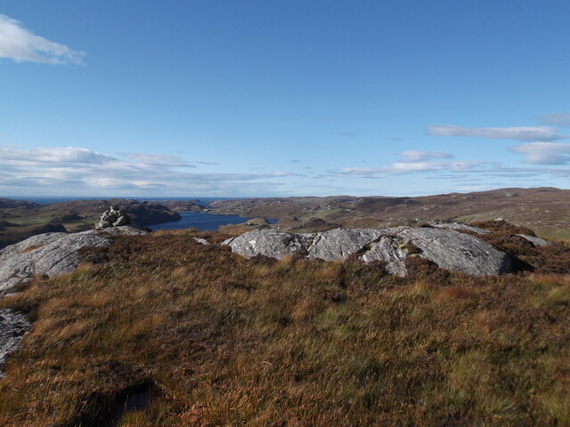
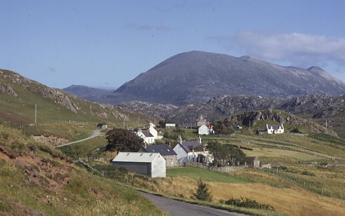
Achlyness is a small hamlet located in the Sutherland region of the Scottish Highlands. Situated in the northern part of the country, it lies approximately 2 miles southeast of the town of Dornoch. The settlement is nestled in a picturesque valley, surrounded by rolling hills and stunning natural landscapes.

The population of Achlyness is relatively small, with only a handful of households. The main industry in the area is agriculture, with sheep farming being a prominent activity. The residents of Achlyness enjoy a peaceful and tranquil lifestyle, with the nearest amenities and services found in Dornoch.

The hamlet is known for its rich history, with evidence of early human habitation in the surrounding areas dating back thousands of years. Archaeological sites, such as standing stones and burial cairns, can be found in the vicinity, serving as a reminder of the area's ancient past.

Achlyness is a popular destination for outdoor enthusiasts, offering a range of activities including hiking, fishing, and bird-watching. The nearby Loch Fleet National Nature Reserve provides a habitat for various bird species, including ospreys and pink-footed geese, attracting wildlife enthusiasts from far and wide.

Visitors to Achlyness can also explore the nearby Dornoch Cathedral, a magnificent medieval structure that dates back to the 13th century. The cathedral boasts stunning architecture and beautiful stained glass windows, making it a popular tourist attraction in the area.

Overall, Achlyness offers a peaceful retreat in the heart of the Scottish Highlands, where visitors can immerse themselves in nature and explore the region's rich history.

If you have any feedback on the listing, please let us know in the comments section below.

Achlyness Images

Images are sourced within 2km of 58.425729/-5.001068 or Grid Reference NC2452. Thanks to Geograph Open Source API. All images are credited.

Looking north along the A838
Trig point at summit area of Garbh Shron Although the pillar is on the very rocky top of Garbh Shron it's known to the OS by the name of an adjacent hill top, Creag an Fhithich There's no flush bracket and the pillar has never had one. The distant, central hill is Farrmheal.
Trig point at summit area of Garbh Shron
Although the pillar is on the very rocky top of Garbh Shron it's known to the OS by the name of an adjacent hill top, Creag an Fhithich There's no flush bracket and the pillar has never had one. The distant, central hill is Farrmheal.
Ceathramh Garbh
Ceathramh Garbh
The head of Loch Inchard The loch runs north westwards towards the ocean and is hemmed in by lumpy gneiss hills.
The head of Loch Inchard
The loch runs north westwards towards the ocean and is hemmed in by lumpy gneiss hills.
Rhiconich river, approaching old bridge
Broken Dam, Achriesgill
Waterfall below the broken dam
Summit rocks, Garbh Shron
Ruin by Loch Inchard
Old bridge over Achriesgill Water
View from Creag An Fhithich Trig Point
Loch Inchard
Loch Inchard
Achriesgill Bay A small bay to the east of Loch Inchard
Achriesgill Bay
A small bay to the east of Loch Inchard
Loch Inchard from Rhiconich
Sign for Kinlochbervie The A838 runs 83 miles from Dalchork to Tongue, via Durness, in NW Scotland.
<span class="nowrap"><a title="https://www.sabre-roads.org.uk/wiki/index.php?title=A838" rel="nofollow ugc noopener" href="https://www.sabre-roads.org.uk/wiki/index.php?title=A838">Link</a><img style="margin-left:2px;" alt="External link" title="External link - shift click to open in new window" src="https://s1.geograph.org.uk/img/external.png" width="10" height="10"/></span>
Sign for Kinlochbervie
The A838 runs 83 miles from Dalchork to Tongue, via Durness, in NW Scotland. LinkExternal link
A838 The A838 runs 83 miles from Dalchork to Tongue, via Durness, in NW Scotland.
<span class="nowrap"><a title="https://www.sabre-roads.org.uk/wiki/index.php?title=A838" rel="nofollow ugc noopener" href="https://www.sabre-roads.org.uk/wiki/index.php?title=A838">Link</a><img style="margin-left:2px;" alt="External link" title="External link - shift click to open in new window" src="https://s1.geograph.org.uk/img/external.png" width="10" height="10"/></span>
A838
The A838 runs 83 miles from Dalchork to Tongue, via Durness, in NW Scotland. LinkExternal link
Shed by the A838 Beside the Allt an Easain Ghairbh. Inside there is a hydroelectric generator.
Shed by the A838
Beside the Allt an Easain Ghairbh. Inside there is a hydroelectric generator.
Old Bridge at Rhiconich Single span rubble bridge, built circa 1835. It is classified Category B. This is now bypassed
Old Bridge at Rhiconich
Single span rubble bridge, built circa 1835. It is classified Category B. This is now bypassed
Show me another place!

Achlyness is located at Grid Ref: NC2452 (Lat: 58.425729, Lng: -5.001068)

Unitary Authority: Highland

Police Authority: Highlands and Islands

What 3 Words

///cemented.science.inclines. Near Oldshoremore, Highland

Related Wikis

Achlyness

Achlyness (Scottish Gaelic:Achadh Linn an Eas) is a crofting hamlet on the shores of Loch Inchard, located near Rhiconich, Sutherland, Scotland, within...

Rhiconich

Rhiconich is a remote hamlet, located at the head of Loch Inchard, in Sutherland, Scottish Highlands in the Scottish council area of Highland. Rhiconich...

Achriesgill

Achriesgill (Scottish Gaelic: Achadh Rìdhisgil) is a village that lies on the eastern bank of Loch Inchard in Lairg, Sutherland, in the Scottish council...

Inshegra

Inshegra is a small crofting village, located two miles south east of Badcall and lies at the south east coast of Loch Inchard, in Lairg, Sutherland,...

Related Videos

Fishing Lochinchard plus holiday accomodation Lochinchard holiday cottages

Holiday footage from Lochinchard and also a lookaround in our accomodation. Kinlochbervie is a place in the highlands in ...

Nearby Amenities

Located within 500m of 58.425729,-5.001068
Source: PGS
Lat/Long: 58.4250448/-4.9928131
Source: PGS
Lat/Long: 58.4249191/-4.9929297
Source: PGS
Lat/Long: 58.4241355/-4.9948352
Source: PGS
Lat/Long: 58.4253487/-4.9957813
Source: PGS
Lat/Long: 58.4256323/-4.996127
Source: PGS
Lat/Long: 58.4258117/-4.9964501
Source: PGS
Lat/Long: 58.4259575/-4.9965129
Source: PGS
Lat/Long: 58.4261138/-4.9967673
Source: PGS
Lat/Long: 58.4263134/-4.9968513
Source: PGS
Lat/Long: 58.4269404/-4.9978712
Source: PGS
Lat/Long: 58.4272711/-4.9983058
Source: PGS
Lat/Long: 58.4274506/-4.9985521
Source: PGS
Lat/Long: 58.4278379/-4.9991783
Source: PGS
Lat/Long: 58.4282963/-4.9999572
Source: PGS
Lat/Long: 58.4289247/-5.0006384
Source: PGS
Lat/Long: 58.4294345/-5.0011861
Source: PGS
Lat/Long: 58.4298906/-5.0018351
Achlyness
Place: hamlet
Wikidata: Q3149370
Wikipedia: en:Achlyness
Lat/Long: 58.4261591/-5.0002672
Power: pole
Lat/Long: 58.4231548/-4.994397
Power: pole
Lat/Long: 58.4230837/-4.9956411
Power: pole
Lat/Long: 58.4219432/-5.0019524
Passing Place
Lat/Long: 58.4260306/-5.0020853
Passing Place
Lat/Long: 58.4256574/-5.0010661
Passing Place
Lat/Long: 58.4240226/-4.9984785
Passing Place
Lat/Long: 58.424393/-4.9989088
The data included in this document is from www.openstreetmap.org. The data is made available under ODbL.

Have you been to Achlyness?

Leave your review of Achlyness below (or comments, questions and feedback).