Granary Wharf

Settlement in Yorkshire

England

Granary Wharf

Merrion House, Leeds A large council office that has been redeveloped in the last couple of years. See <a href="https://www.geograph.org.uk/photo/585082">SE3034 : Merrion House - Clay Pit Lane</a> for a 'before' view.
Merrion House, Leeds Credit: Stephen Craven

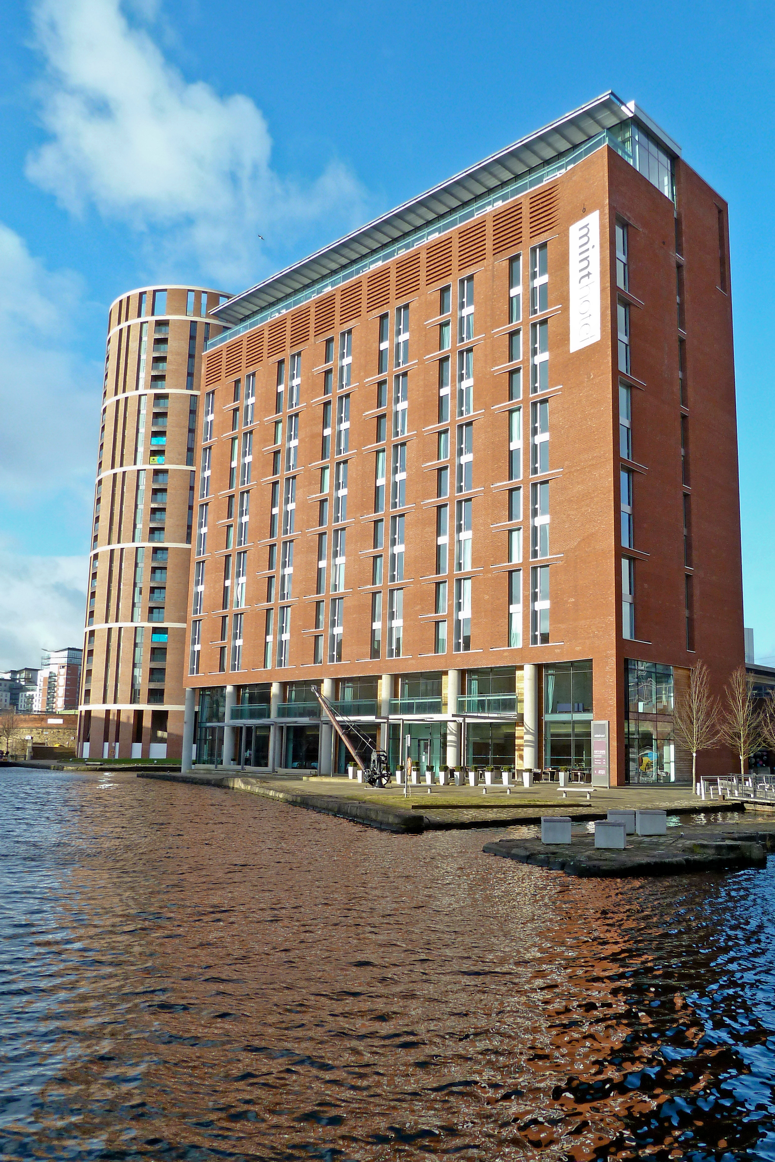
Granary Wharf is a vibrant and bustling waterfront area located in the city of Leeds, Yorkshire, England. Situated at the southern end of the Leeds and Liverpool Canal, it has undergone a major transformation in recent years, becoming a popular destination for both residents and visitors.

The area takes its name from the historic granaries that once stood here, serving as storage facilities for the thriving grain trade in the 19th century. Today, Granary Wharf is a lively mixed-use development that seamlessly blends the old with the new. The original industrial buildings have been carefully restored and repurposed, now housing a variety of trendy bars, restaurants, and shops.

One of the highlights of Granary Wharf is its picturesque waterfront setting. The canal basin is a hub of activity, with colorful narrowboats moored along the quayside and water taxis offering leisurely cruises along the canal. The area is also home to a number of outdoor seating areas, providing a perfect spot to relax and enjoy the vibrant atmosphere.

Granary Wharf is well-connected, with Leeds train station just a stone's throw away. This accessibility has attracted a mix of professionals, students, and families to the area, resulting in a diverse and lively community. The nearby Leeds city center offers a wide range of amenities, including shopping centers, theaters, and cultural attractions, making Granary Wharf an ideal base for exploring the wider city.

In conclusion, Granary Wharf is a vibrant waterfront development in Leeds, Yorkshire, with a rich history and a thriving modern community. Its blend of historic buildings, trendy venues, and scenic surroundings make it a must-visit destination for locals and tourists alike.

If you have any feedback on the listing, please let us know in the comments section below.

Granary Wharf Images

Images are sourced within 2km of 53.793276/-1.5496447 or Grid Reference SE2933. Thanks to Geograph Open Source API. All images are credited.

Merrion House, Leeds A large council office that has been redeveloped in the last couple of years. See <a href="https://www.geograph.org.uk/photo/585082">SE3034 : Merrion House - Clay Pit Lane</a> for a 'before' view.
Merrion House, Leeds
A large council office that has been redeveloped in the last couple of years. See SE3034 : Merrion House - Clay Pit Lane for a 'before' view.
St John's, Leeds - nave looking east Viewed from near the west end of the north aisle, showing the century box pews of 1807, which had their doors removed in the 1860s restoration.
St John's, Leeds - nave looking east
Viewed from near the west end of the north aisle, showing the century box pews of 1807, which had their doors removed in the 1860s restoration.
St John's, Leeds - nave looking west Viewed from near the east end of the main aisle, showing the century box pews of 1807, which had their doors removed in the 1860s restoration.
St John's, Leeds - nave looking west
Viewed from near the east end of the main aisle, showing the century box pews of 1807, which had their doors removed in the 1860s restoration.
St John's, Leeds - pew details The box pews were introduced in 1807, but had their doors removed in the 1860s restoration. The brass plaques such as the one here mark as closely as possible the location of burial vaults beneath the nave.
St John's, Leeds - pew details
The box pews were introduced in 1807, but had their doors removed in the 1860s restoration. The brass plaques such as the one here mark as closely as possible the location of burial vaults beneath the nave.
St John's, Leeds - arms of James I The church has a twin-aisled nave, and above the chancel screen on each side is a Royal coat of arms; this to the north aisle is the arms of James I (James VI of Scotland), which the church guide leaflet says is a historical oddity as he had died before the church opened in 1634 but may reflect the Scottish sympathies of benefactor John Harrison.
St John's, Leeds - arms of James I
The church has a twin-aisled nave, and above the chancel screen on each side is a Royal coat of arms; this to the north aisle is the arms of James I (James VI of Scotland), which the church guide leaflet says is a historical oddity as he had died before the church opened in 1634 but may reflect the Scottish sympathies of benefactor John Harrison.
St John's, Leeds - arms of Charles I The church has a twin-aisled nave, and above the chancel screen on each side is a Royal coat of arms; this to the south aisle is the arms of Charles I but as Prince of Wales rather than King.
St John's, Leeds - arms of Charles I
The church has a twin-aisled nave, and above the chancel screen on each side is a Royal coat of arms; this to the south aisle is the arms of Charles I but as Prince of Wales rather than King.
St John's, Leeds - pulpit The church was probably originally provided with seating facing north with this imposing pulpit by Francis Gunby in the middle of the north wall, in Protestant tradition; it was moved further east in the 1880s restoration.
St John's, Leeds - pulpit
The church was probably originally provided with seating facing north with this imposing pulpit by Francis Gunby in the middle of the north wall, in Protestant tradition; it was moved further east in the 1880s restoration.
St John's, Leeds - communion table The church had a distinctly Protestant foundation, so it would be misleading to call this 17th century communion table an 'altar'. The reredos mosaic is by R N Shaw, and the 'wings' either side added by Temple Moore, coming from an old organ case.
St John's, Leeds - communion table
The church had a distinctly Protestant foundation, so it would be misleading to call this 17th century communion table an 'altar'. The reredos mosaic is by R N Shaw, and the 'wings' either side added by Temple Moore, coming from an old organ case.
St John's, Leeds - Harrison memorial A memorial in the style of a table tomb to the church's founder, merchant John Harrison.
St John's, Leeds - Harrison memorial
A memorial in the style of a table tomb to the church's founder, merchant John Harrison.
St John's, Leeds - window in the Harrison chapel The outer two of the four lights of this stained glass window depict six of the seven 'acts of mercy' and the centre lights depict that favourite Bible verse of the Victorians, "Suffer the little children to come unto Me". It was given in memory of Revd Edward Munro (1815-1866), sometime Vicar of the church.
St John's, Leeds - window in the Harrison chapel
The outer two of the four lights of this stained glass window depict six of the seven 'acts of mercy' and the centre lights depict that favourite Bible verse of the Victorians, "Suffer the little children to come unto Me". It was given in memory of Revd Edward Munro (1815-1866), sometime Vicar of the church.
St John's, Leeds - west window The stained glass window of 1859 depicts scenes from the life of John the Baptist.
St John's, Leeds - west window
The stained glass window of 1859 depicts scenes from the life of John the Baptist.
St John's, Leeds - shields These two shields (if that is the correct term) on the west wall of the nave bear Latin inscriptions: "fac cum sanctis munerari" ("let me be rewarded with the saints", from the Te Deum) and "sic Deus dilexit mundum" ("God so loved the world").
St John's, Leeds - shields
These two shields (if that is the correct term) on the west wall of the nave bear Latin inscriptions: "fac cum sanctis munerari" ("let me be rewarded with the saints", from the Te Deum) and "sic Deus dilexit mundum" ("God so loved the world").
A58 Clay Pit Lane Leeds
Queen Square gardens Leeds
Queen Square houses Leeds
Leeds Kirkgate Market
New cycle crossing on Meadow Road Meadow Road and Dewsbury Road were once quite separate streets with buildings between.  With a degree of realignment on the Meadow Road side, they now effectively form the two halves of a dual carriageway at this point.  The cycle crossing to give access to Holmes Street and the Crown Point retail park is only recently completed: see <a href="https://www.geograph.org.uk/photo/6871384">SE2932 : Cycle lane under construction, Meadow Road, Leeds</a> for when it was still under construction in June.
New cycle crossing on Meadow Road
Meadow Road and Dewsbury Road were once quite separate streets with buildings between. With a degree of realignment on the Meadow Road side, they now effectively form the two halves of a dual carriageway at this point. The cycle crossing to give access to Holmes Street and the Crown Point retail park is only recently completed: see SE2932 : Cycle lane under construction, Meadow Road, Leeds for when it was still under construction in June.
Civica, Holmes Street Seen from the new pedestrian / cycle crossing on Dewsbury Road. This was one of the buildings of the former Union Mills and is now home to a software developer. see <a href="https://www.geograph.org.uk/photo/6871397">SE3032 : Civica, Holmes Street, Leeds</a> for another view.
Civica, Holmes Street
Seen from the new pedestrian / cycle crossing on Dewsbury Road. This was one of the buildings of the former Union Mills and is now home to a software developer. see SE3032 : Civica, Holmes Street, Leeds for another view.
Show me another place!

Granary Wharf is located at Grid Ref: SE2933 (Lat: 53.793276, Lng: -1.5496447)

Division: West Riding

Unitary Authority: Leeds

Police Authority: West Yorkshire

What 3 Words

///transit.host.tribal. Near Leeds, West Yorkshire

Related Wikis

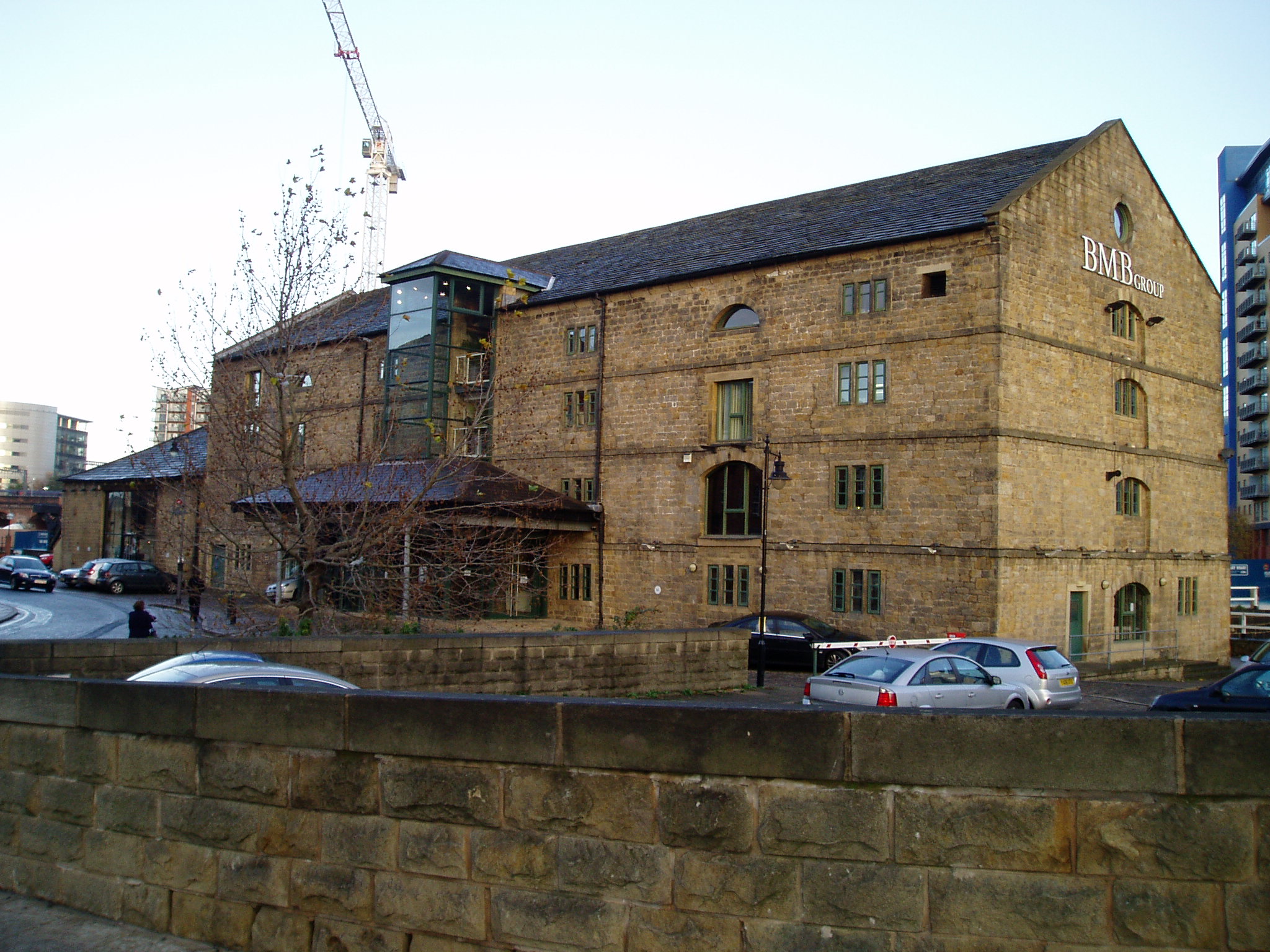
Granary Buildings, Leeds

Granary Buildings is a heritage listed building in Leeds, West Yorkshire, England. == History == Built in around 1776 as a warehouse for the Leeds & Liverpool...

Leeds and Liverpool Canal

The Leeds and Liverpool Canal is a canal in Northern England, linking the cities of Leeds and Liverpool. Over a distance of 127 miles (204 km), crossing...

Medical Protection Society

The Medical Protection Society (MPS) is one of the three UK mutual protection organisations for medical, dental and healthcare professionals. (Dentists...

Granary Wharf

Granary Wharf is a mixed-use development that stands next to the brick tunnels beside the Leeds and Liverpool Canal, and the River Aire in Leeds, West...

Nearby Amenities

Located within 500m of 53.793276,-1.5496447
Crossing
Lat/Long: 53.7951853/-1.5457436
Crossing
Crossing: traffic_signals
Tactile Paving: yes
Lat/Long: 53.7941922/-1.5437319
Crossing: informal
Lat/Long: 53.7931507/-1.5510866
Seamark Type: gate
Waterway: lock_gate
Lat/Long: 53.7928436/-1.5482758
Seamark Type: gate
Waterway: lock_gate
Lat/Long: 53.7930281/-1.5515727
Pub
Scarborough Hotel
Addr City: Leeds
Addr Housenumber: 3
Addr Postcode: LS1 5DY
Addr Street: Bishopgate Street
Alt Name: Scarborough Taps
Brand: Nicholson's
Brand Wikidata: Q113130666
Fhrs Id: 321498
Floor Material: stone
Food: yes
Operator: Nicholson's
Real Ale: 4 or 5 beers
Website: https://www.nicholsonspubs.co.uk/restaurants/yorkshireandthehumber/thescarbroughhotelbishopsgatestreetleeds
Wheelchair: yes
Wheelchair Description: slight lip at entrance but unlikely to cause a problem
Lat/Long: 53.7954088/-1.5463654
Pub
The Head of Steam
Addr City: Leeds
Addr Postcode: LS1 5DQ
Addr Street: Mill Hill
Fhrs Id: 765498
Lat/Long: 53.7953226/-1.5458167
Crossing
Button Operated: yes
Crossing: traffic_signals
Crossing Island: no
Crossing Markings: dots
Crossing Ref: pelican
Kerb: lowered
Tactile Paving: yes
Traffic Signals Sound: no
Traffic Signals Vibration: yes
Lat/Long: 53.7912915/-1.5438679
Post Box
Brand: Royal Mail
Brand Wikidata: Q638098
Brand Wikipedia: en:Royal Mail
Collection Times: Mo-Fr 18:45; Sa 11:30
Indoor: no
Layer: 1
Operator: Royal Mail
Operator Wikidata: Q638098
Post Box Type: pillar
Ref: LS1 41
Royal Cypher: EIIR
Royal Cypher Wikidata: Q33102113
Source: survey
Lat/Long: 53.7951553/-1.5472444
Traffic Signals
Crossing: traffic_signals
Crossing Ref: pelican
Kerb: lowered
Tactile Paving: yes
Traffic Signals Direction: forward
Lat/Long: 53.7915772/-1.5470237
Barrier: bollard
Bicycle: yes
Bollard: fixed
Foot: yes
Horse: yes
Motor Vehicle: no
Lat/Long: 53.7901082/-1.544918
Disused Amenity: post_box
Note: Post box LS11 391 removed.
Source: http://pberry.me.uk/osm/node/52049871.jpeg
Source Date: 2023-02-22
Lat/Long: 53.789571/-1.5521039
Mini Roundabout
Direction: clockwise
Lat/Long: 53.7888508/-1.5483226
Pub
The Red Lion
Lat/Long: 53.7945085/-1.5424824
Post Box
Brand: Royal Mail
Brand Wikidata: Q638098
Brand Wikipedia: en:Royal Mail
Operator: Royal Mail
Operator Wikidata: Q638098
Post Box Type: pillar
Ref: LS1 999
Royal Cypher: EIIR
Royal Cypher Wikidata: Q33102113
Lat/Long: 53.7932524/-1.5458583
Railway: signal
Lat/Long: 53.7927335/-1.5551666
Bus Station
Infirmary Street
Bus: yes
Naptan AtcoCode: 450G7637
Public Transport: station
Lat/Long: 53.7975594/-1.5487666
Leeds Station Interchange
Addr Street: New Station Street
Bus: no
Check Date: 2022-01
Lat/Long: 53.7953115/-1.5470966
Taxi
Note: New Station Street closed, temp taxi rank on Aire Street (here) then moved to Bishopgate Street (opp. Scarborough Hotel) old bus stop "station D"
Source: local knowledge
Lat/Long: 53.7954763/-1.5485823
Junction: yes
Junction Ref: 17
Lat/Long: 53.7941573/-1.5433024
Crossing
Crossing: marked
Crossing Markings: yes
Tactile Paving: no
Lat/Long: 53.7949364/-1.5443818
Source: survey
Lat/Long: 53.7950422/-1.5432509
P9 Boar Lane
Bench: yes
Bin: yes
Bus: yes
Lit: yes
Local Ref: 45012657
Naptan AtcoCode: 450012657
Naptan Bearing: E
Naptan CommonName: P9 Boar Lane
Naptan Crossing: Mill Hill
Naptan Indicator: Stop 45012657
Naptan Landmark: Leeds Shopping Plaza
Naptan PlusbusZoneRef: LEEDS
Naptan ShortCommonName: Boar Lane P9
Naptan Street: Boar Lane
Naptan Verified: yes
Shelter: yes
Source: naptan_import;survey
Tactile Paving: no
Timetable: yes
Lat/Long: 53.7958966/-1.5455066
P8 Boar Lane
Bus: yes
Demolished Highway: bus_stop
Local Ref: 45012656
Naptan AtcoCode: 450012656
Naptan Bearing: E
Naptan CommonName: P8 Boar Lane
Naptan Crossing: Mill Hill
Naptan Indicator: Stop 45012656
Naptan Landmark: Leeds Shopping Plaza
Naptan PlusbusZoneRef: LEEDS
Naptan ShortCommonName: Boar Lane P8
Naptan Street: Boar Lane
Naptan Verified: yes
Public Transport: no
Shelter: yes
Source: naptan_import;survey
Timetable: yes
Lat/Long: 53.7959395/-1.5458044
Bus Stop
Station D
Bus: yes
Local Ref: 45032123
Naptan AtcoCode: 450012655
Naptan Bearing: E
Naptan CommonName: P7 Boar Lane
Naptan Crossing: Mill Hill
Naptan Indicator: Stop 45012655
Naptan Landmark: Leeds Shopping Plaza
Naptan PlusbusZoneRef: LEEDS
Naptan ShortCommonName: Boar Lane P7
Naptan Street: Boar Lane
Naptan Verified: yes
Network: Metro West Yorkshire
Network Wikidata: Q7987043
New Name: Station D
Public Transport: platform
Ref: 45032123
Shelter: yes
Source: naptan_import;survey
Timetable: yes
Lat/Long: 53.7959393/-1.5458095
Bus Stop
Station C
Bench: yes
Bin: no
Bus: yes
Lit: yes
Local Ref: 45024834
Naptan AtcoCode: 450024834
Naptan Bearing: SE
Naptan CommonName: P6A Boar Lane
Naptan Crossing: Park Row
Naptan Indicator: Stop 45024834
Naptan Landmark: Park Plaza Hotel
Naptan PlusbusZoneRef: LEEDS
Naptan ShortCommonName: Boar Lane P6A
Naptan Street: Boar Lane
Naptan Verified: yes
Network: Metro West Yorkshire
Network Wikidata: Q7987043
New Name: Station C
Public Transport: platform
Ref: 45024834
Shelter: yes
Source: naptan_import
Tactile Paving: no
Timetable: yes
Lat/Long: 53.7960767/-1.5464658
Pub
Viaduct Showbar
Addr City: Leeds
Addr Housenumber: 11
Addr Postcode: LS1 6ER
Addr Street: Briggate
Contact Facebook: https://www.facebook.com/viaductshowbar/
Contact Twitter: https://twitter.com/ViaductShowBar
Fhrs Id: 321510
Lgbtq: primary
Not Addr Postcode: LS1 6EP
Phone: +44 113 344 9552
Source Addr Postcode: code-point_open
Website: https://www.viaductleeds.com/
Lat/Long: 53.7950322/-1.5426851
Bus Stop
City Square I
Bench: yes
Bin: yes
Bus: yes
Lit: yes
Live Display: yes
Local Ref: 45010704
Naptan AtcoCode: 450010704
Naptan Bearing: S
Naptan CommonName: P4 Leeds Park Row
Naptan Crossing: Nr-Opp Infirmary Street
Naptan Indicator: Stop 45010704
Naptan PlusbusZoneRef: LEEDS
Naptan ShortCommonName: Park Row P4
Naptan Street: Park Row
Naptan Verified: yes
Public Transport: platform
Ref: 450010704
Shelter: yes
Source: naptan_import;survey
Tactile Paving: no
Timetable: yes
Lat/Long: 53.7970342/-1.5469982
Bus Stop
City Square H
Bench: yes
Bin: yes
Bus: yes
Lit: yes
Local Ref: 45010702
Naptan AtcoCode: 450010702
Naptan Bearing: S
Naptan CommonName: P3 Leeds Park Row
Naptan Crossing: Nr-At Bond Street
Naptan Indicator: Stop 45010702
Naptan PlusbusZoneRef: LEEDS
Naptan ShortCommonName: Park Row P3
Naptan Street: Park Row
Naptan Verified: yes
Public Transport: platform
Ref: 450010702
Shelter: yes
Source: naptan_import;survey
Tactile Paving: no
Lat/Long: 53.7972546/-1.5469632
Fountain
Lat/Long: 53.7954766/-1.5438121
Bus Stop
City Square E
Bench: yes
Bin: yes
Bus: yes
Demolished Highway: bus_stop
Lit: yes
Live Display: yes
Local Ref: 45032243
Naptan AtcoCode: 450025320
Naptan Bearing: NW
Naptan CommonName: E Leeds Infirmary Street
Naptan Crossing: Nr-At East Parade
Naptan Indicator: Stop 45032243
Naptan Landmark: Infirmary Street Bus Point
Naptan PlusbusZoneRef: LEEDS
Naptan ShortCommonName: Infirmary Street E
Naptan Street: Infirmary Street (Central Island)
Naptan Verified: yes
Public Transport: platform
Ref: 45032243
Shelter: yes
Source: naptan_import
Tactile Paving: no
Timetable: yes
Lat/Long: 53.7975707/-1.5489553
Bus Stop
City Square C
Bench: yes
Bin: yes
Bus: yes
Demolished Highway: bus_stop
Lit: yes
Naptan AtcoCode: 450032241
Naptan NaptanCode: 45032241
Public Transport: platform
Ref: 45032241
Shelter: yes
Tactile Paving: no
Lat/Long: 53.7970395/-1.5480473
Bus Stop
Wellington C
Bench: yes
Bin: no
Bus: yes
Local Ref: 45029950
Naptan AtcoCode: 450029950
Naptan NaptanCode: 45029950
Old Name: W1 Wellington Street
Passenger Information Display: yes
Public Transport: platform
Ref: 45029950
Shelter: yes
Lat/Long: 53.7965002/-1.5536889
Malmaison Hotel
Addr City: Leeds
Addr Housenumber: 1
Addr Postcode: LS1 4AG
Addr Street: Swinegate
Brand: Malmaison
Brand Wikidata: Q6744343
Fhrs Id: 321414
Tourism: hotel
Lat/Long: 53.7942234/-1.5424975
City Square
Junction: yes
Junction Ref: 1
Lat/Long: 53.796171/-1.547994
Bank of England
Junction: yes
Junction Ref: 2
Lat/Long: 53.7973535/-1.5501215
Mini Roundabout
Direction: clockwise
Lat/Long: 53.7957225/-1.5490841
Turning Circle
Lat/Long: 53.7936861/-1.5558301
Barrier: bollard
Bollard: fixed
Lat/Long: 53.7932891/-1.5553356
Barrier: bollard
Bollard: fixed
Lat/Long: 53.7936425/-1.5557584
Barrier: bollard
Bollard: removable
Lat/Long: 53.7949659/-1.5533491
Bicycle Parking
Bicycle Parking: stands
Capacity: 10
Covered: no
Lat/Long: 53.7948236/-1.5532378
Pub
Leeds City Station
Addr City: Leeds
Addr County: West Yorkshire
Addr Housename: North Concourse
Addr Housenumber: Unit 4
Addr Postcode: LS1 4DY
Addr Street: New Station Street
Address1: North Concourse
Brand: Wetherspoon
Brand Wikidata: Q6109362
Brand Wikipedia: en:Wetherspoons
Brewery: various
Contact Phone: 0113 247 1676
Contact Website: https://www.jdwetherspoon.com/pubs/all-pubs/england/west-yorkshire/wetherspoons-leeds
Diet Vegan: Yes
Diet Vegetarian: Yes
Fhrs Id: 321009
Food: yes
Internet Access: wlan
Internet Access Fee: no
Internet Access Ssid: _The Cloud
Note: Has TV screens
Outdoor Seating: yes
Payment Debit Cards: Yes
Payment Mastercard: Yes
Payment Visa: Yes
Real Ale: yes
Smoking: outside
Toilets: yes
Toilets Access: customers
Wheelchair: yes
Lat/Long: 53.7957046/-1.5486597
Arts Centre
Project Space Leeds
Lat/Long: 53.7935659/-1.5566836
Bus Stop
Wellington N
Bench: no
Bin: yes
Bus: yes
Lit: no
Local Ref: 45025848
Naptan AtcoCode: 450025848
Naptan Bearing: SW
Naptan CommonName: S17 Leeds Whitehall Road
Naptan Crossing: Nr-At Globe Road
Naptan Indicator: Stop 45025848
Naptan Landmark: Adj Monk Bridge
Naptan PlusbusZoneRef: LEEDS
Naptan ShortCommonName: Airedale Centre
Naptan Street: Whitehall Road
Naptan Verified: yes
Old Name: S17 Leeds Whitehall Road
Public Transport: platform
Ref: 45025848
Shelter: no
Source: naptan_import
Tactile Paving: no
Lat/Long: 53.7942429/-1.5568744
Cafe
Hive
Addr City: Leeds
Addr Housename: Whitehall Riverside
Addr Postcode: LS1 4BN
Addr Street: Whitehall Road
Addr Unit: 1
Fhrs Id: 1018420
Lat/Long: 53.7945013/-1.5538378
Power: substation
Lat/Long: 53.7948385/-1.5530697
Traffic Signals
Crossing: traffic_signals
Crossing Ref: pelican
Kerb: flush
Tactile Paving: yes
Traffic Signals Direction: backward
Lat/Long: 53.7963258/-1.5513906
Restaurant
Bibis Italianissimo
Addr City: Leeds
Addr Postcode: LS1 4AG
Cuisine: italian
Fhrs Id: 321102
Lat/Long: 53.7943229/-1.5446264
The Black Prince
Artist Name: Thomas Brock
Artwork Type: statue
Tourism: artwork
Wikidata: Q17533834
Lat/Long: 53.796387/-1.5475797
Restaurant
Banyan
Addr City: Leeds
Addr Postcode: LS1 2ES
Addr Street: City Square
Check Date: 2024-02-12
Fhrs Id: 899501
Wheelchair: no
Lat/Long: 53.7968026/-1.5478087
Restaurant
The Restaurant Bar & Grill
Addr City: Leeds
Addr Housename: The Old Post Office
Addr Housenumber: 3
Addr Postcode: LS1 2HA
Addr Street: City Square
Check Date: 2024-02-12
Fhrs Id: 321477
Wheelchair: no
Lat/Long: 53.796645/-1.5480667
Crossing
Crossing: uncontrolled
Crossing Markings: zebra
Crossing Ref: zebra
Lat/Long: 53.7917689/-1.5463139
Crossing
Crossing: uncontrolled
Crossing Markings: zebra
Crossing Ref: zebra
Lat/Long: 53.7915216/-1.5448694
Traffic Signals
Traffic Signals: signal
Traffic Signals Direction: backward
Lat/Long: 53.7918913/-1.5430702
Restaurant
Brasserie Blanc
Addr City: Leeds
Addr Postcode: LS1 4BA
Fhrs Id: 321802
Lat/Long: 53.7928229/-1.5443781
Restaurant
Chaophraya
Addr City: Leeds
Addr Housenumber: 20a
Addr Postcode: LS1 4AG
Addr Street: Swinegate
Cuisine: thai
Fhrs Id: 349033
Lat/Long: 53.7943767/-1.5438601
Disused: yes
Historic: crane
Man Made: crane
Wikidata: Q26547275
Lat/Long: 53.7928757/-1.5492637
Power: substation
Lat/Long: 53.792122/-1.5499715
Crossing
Lat/Long: 53.7920842/-1.5473986
Crossing
Crossing: uncontrolled
Kerb: lowered
Tactile Paving: yes
Lat/Long: 53.7894511/-1.5456356
Crossing
Button Operated: no
Crossing: traffic_signals
Crossing Ref: informal
Informal: yes
Kerb: lowered
Tactile Paving: yes
Traffic Signals Sound: no
Traffic Signals Vibration: no
Lat/Long: 53.7911431/-1.5439603
Barrier: bollard
Bollard: removable
Lat/Long: 53.7932231/-1.5445107
Tourism: artwork
Lat/Long: 53.7927807/-1.5446149
Telephone
Booth: KXPlus
Covered: booth
Operator: BT
Operator Wikidata: Q593786
Lat/Long: 53.7939788/-1.5432041
Post Box
Brand: Royal Mail
Brand Wikidata: Q638098
Brand Wikipedia: en:Royal Mail
Collection Covid19: priority
Collection Plate Date: 2018-10-03
Collection Times: Mo-Fr 18:00; Sa 12:30
Colour: red
Operator: Royal Mail
Operator Wikidata: Q638098
Post Box Apertures: 2
Post Box Design: type_c
Post Box Type: pillar
Ref: LS1 148;LS1 1148
Royal Cypher: EIIR
Royal Cypher Wikidata: Q33102113
Source: survey
Survey Date: 2021-11-24
Lat/Long: 53.7966862/-1.550555
Post Box
Brand: Royal Mail
Brand Wikidata: Q638098
Brand Wikipedia: en:Royal Mail
Collection Covid19: priority
Collection Times: Mo-Fr 18:00; Sa 12:15
Colour: red
Operator: Royal Mail
Operator Wikidata: Q638098
Post Box Type: meter
Ref: LS1 53P
Royal Cypher: no
Source: survey
Survey Date: 2021-10-24
Lat/Long: 53.7966635/-1.5505672
Post Box
Brand: Royal Mail
Brand Wikidata: Q638098
Brand Wikipedia: en:Royal Mail
Collection Covid19: priority
Collection Times: Mo-Fr 09:00; Sa 07:00
Colour: red
Operator: Royal Mail
Operator Wikidata: Q638098
Post Box Design: type_k
Post Box Type: pillar
Ref: LS1 95
Royal Cypher: EIIR
Royal Cypher Wikidata: Q33102113
Source: survey
Survey Date: 2021-11-24
Lat/Long: 53.7957705/-1.5459555
Bishopgate
Junction: yes
Junction Ref: 18
Lat/Long: 53.7951481/-1.5460923
Crossing
Lat/Long: 53.7951096/-1.5462553
Windsor House
Building: commercial
Lat/Long: 53.7941554/-1.5422689
Bar
Phranakhon Tapas And Bar
Addr City: Leeds
Addr Housenumber: 11
Addr Postcode: LS1 2DS
Addr Street: York Place
Fhrs Id: 1109138
Level: -1
Old Name: The White Rabbit
Lat/Long: 53.7969419/-1.5521028
Post Box
Brand: Royal Mail
Brand Wikidata: Q638098
Brand Wikipedia: en:Royal Mail
Collection Times: Mo-Fr 16:45, Sa 12:30
Indoor: yes
Operator: Royal Mail
Operator Wikidata: Q638098
Post Box Type: pillar
Ref: LS1 39
Royal Cypher: EIIR
Royal Cypher Wikidata: Q33102113
Lat/Long: 53.7953036/-1.5476335
Post Box
Brand: Royal Mail
Brand Wikidata: Q638098
Brand Wikipedia: en:Royal Mail
Operator: Royal Mail
Operator Wikidata: Q638098
Post Box Type: meter
Ref: LS1 49
Lat/Long: 53.7932536/-1.5459827
Telephone
Booth: K6
Covered: booth
Disused: yes
Listed Status: Grade II
Lat/Long: 53.7964684/-1.5482503
Telephone
Booth: K6
Covered: booth
Listed Status: Grade II
Not Operator Wikidata: Q593786
Note: door screwed shut
Operator: BT
Lat/Long: 53.7965144/-1.5481765
Telephone
Booth: K6
Covered: booth
Disused: yes
Listed Status: Grade II
Lat/Long: 53.7966795/-1.5478872
Telephone
Booth: K6
Covered: booth
Disused: yes
Listed Status: Grade II
Lat/Long: 53.7965706/-1.5480817
Fast Food
Bagel Factory
Addr City: Leeds
Addr Housename: City Station
Addr Housenumber: Unit 2
Addr Postcode: LS1 4DY
Addr Street: New Station Street
Fhrs Id: 321120
Note: Now Bagel Factory? [Current FHRS ID invalid]
Opening Hours: Mo-Fr 06:30-16:00; Sa 09:00-17:00; Su off
Wheelchair: no
Lat/Long: 53.795963/-1.5483679
Police
British Transport Police
Addr City: Leeds
Addr Street: New Station Street
Operator: British Transport Police
Operator Wikidata: Q174588
Website: https://www.btp.police.uk/
Lat/Long: 53.7949052/-1.5460371
S9 Leeds Station Interchange
Bus: no
Check Date: 2022-01
Local Ref: 45025480
Naptan AtcoCode: 450025480
Naptan Bearing: N
Naptan CommonName: S9 Leeds Station Interchange
Naptan Crossing: Leeds Railway Station Forecourt
Naptan Indicator: Stop 45025480
Naptan Landmark: Leeds Railway Station Interchange
Naptan PlusbusZoneRef: LEEDS
Naptan ShortCommonName: Station Intc S9
Naptan Street: New Station Street
Lat/Long: 53.7953716/-1.5471264
Fast Food
LEON
Addr City: Leeds
Addr Housename: City Station
Addr Housenumber: Unit 10
Addr Postcode: LS1 4DT
Addr Street: New Station Street
Addr Unit: 26 North Concourse
Brand: LEON
Brand Wikidata: Q6524851
Brand Wikipedia: en:Leon Restaurants
Cuisine: burger;sandwich
Fhrs Id: 1280341
Takeaway: yes
Website: https://leon.co/restaurants/leeds-station/
Lat/Long: 53.7954908/-1.5482158
Pub
The Beer House
Addr City: Leeds
Addr Housename: City Station
Addr Postcode: LS1 4DT
Addr Street: New Station Street
Addr Unit: 15 South Concourse
Fhrs Id: 1073642
Floor Material: lino
Food: yes
Layer: 1
Opening Hours: Mo-Th 10:00-22:00; Fr,Sa 10:00-23:00; Su 10:00-21:00
Real Ale: Tetley and Wainright Gold, may vary
Wheelchair: yes
Wheelchair Description: Flat entrance, flat access to disabled toilet
Lat/Long: 53.7949019/-1.5471557
Toilets
Access: yes
Changing Table: yes
Fee: no
Female: yes
Layer: 1
Level: 0
Male: yes
Toilets Disposal: flush
Wheelchair: yes
Lat/Long: 53.7948841/-1.5471919
Bus Stop
Station F
Bench: yes
Bin: yes
Bus: yes
Lit: no
Local Ref: 45013262
Naptan AtcoCode: 450013262
Naptan Bearing: S
Naptan CommonName: Z2 Neville Street
Naptan Crossing: Sovereign Street
Naptan Indicator: Stop 45013262
Naptan Landmark: Hilton Hotel
Naptan Notes: Stop in Temp location 24/06/08
Naptan PlusbusZoneRef: LEEDS
Naptan ShortCommonName: Neville Street Z2
Naptan Street: Neville Street
Naptan Verified: yes
Public Transport: platform
Ref: 45013262
Shelter: yes
Source: naptan_import
Tactile Paving: no
Lat/Long: 53.7937299/-1.5466792
Bus Stop
Station E
Bench: yes
Bin: yes
Bus: yes
Lit: no
Local Ref: 45013261
Naptan AtcoCode: 450013261
Naptan Bearing: S
Naptan CommonName: Z3 Neville Street
Naptan Crossing: Sovereign Street
Naptan Indicator: Stop 45013261
Naptan Landmark: Hilton Hotel
Naptan Notes: Stop in Temp location 24/06/08
Naptan PlusbusZoneRef: LEEDS
Naptan ShortCommonName: Neville Street Z3
Naptan Street: Neville Street
Naptan Verified: yes
Public Transport: platform
Ref: 45013261
Shelter: yes
Source: naptan_import
Tactile Paving: no
Lat/Long: 53.7938658/-1.5466387
Entrance: main
Railway: train_station_entrance
Lat/Long: 53.7956133/-1.5484354
Traffic Signals
Traffic Signals: signal
Traffic Signals Direction: forward
Lat/Long: 53.7946258/-1.5561818
Restaurant
Tharavadu
Addr City: Leeds
Addr Housenumber: 7-8
Addr Postcode: LS1 5DQ
Addr Street: Mill Hill
Cuisine: curry;indian
Fhrs Id: 687569
Phone: +44 113 244 0500
Website: https://tharavadurestaurants.com/
Lat/Long: 53.7954449/-1.5455529
Fast Food
Mill Hill Kebabs
Addr City: Leeds
Addr Housenumber: 4-6
Addr Postcode: LS1 5DQ
Addr Street: Mill Hill
Cuisine: kebab
Fhrs Id: 594717
Lat/Long: 53.7955137/-1.5455542
Pub
The Brewery Tap
Addr City: Leeds
Addr Housenumber: 18-24
Addr Postcode: LS1 5DL
Addr Street: New Station Street
Beer Garden: no
Fhrs Id: 1058739
Microbrewery: yes
Operator: Leeds Brewery
Website: https://brewerytapleeds.co.uk/
Lat/Long: 53.7951338/-1.5452228
Cafe
Caffè Nero
Addr City: Leeds
Addr Housenumber: 58
Addr Postcode: LS1 6HW
Addr Street: Boar Lane
Brand: Caffè Nero
Brand Wikidata: Q675808
Brand Wikipedia: en:Caffè Nero
Contact Website: https://caffenero.com/uk/store/leeds-boar-lane-121/
Cuisine: coffee_shop
Fhrs Id: 320994
Takeaway: yes
Lat/Long: 53.7958921/-1.5448893
Post Box
Brand: Royal Mail
Brand Wikidata: Q638098
Brand Wikipedia: en:Royal Mail
Collection Covid19: priority
Collection Times: Mo-Fr 18:00; Sa 12:15
Colour: red
Operator: Royal Mail
Operator Wikidata: Q638098
Post Box Type: meter
Ref: LS1 56P
Royal Cypher: no
Source: survey
Survey Date: 2021-10-24
Lat/Long: 53.7957744/-1.5458456
Taxi
Check Date: 2023-12-19
Lat/Long: 53.7956958/-1.5451807
Crossing
Crossing: uncontrolled
Crossing Markings: zebra
Crossing Ref: zebra
Kerb: lowered
Tactile Paving: yes
Lat/Long: 53.7957058/-1.5456207
Restaurant
Sous le Nez
Addr City: Leeds
Addr Postcode: LS1 2HA
Addr Street: Quebec Street
Cuisine: french
Fhrs Id: 320077
Phone: +44 113 244 0108
Website: https://souslenez.com/
Lat/Long: 53.796555/-1.5490551
University
Leeds Law School
Addr City: Leeds
Addr Housenumber: 10
Addr Postcode: LS1 2HA
Addr Street: Quebec Street
Fhrs Id: 1016325
Operator: Leeds Beckett University
Lat/Long: 53.7967871/-1.5488161
Barrier: lift_gate
Lat/Long: 53.7968532/-1.5494326
West Yorkshire Combined Authority
Office: government
Lat/Long: 53.7963676/-1.5501208
Nightclub
The Purple Door
Wheelchair: yes
Lat/Long: 53.7968671/-1.5516648
Fast Food
Nosh
Addr City: Leeds
Addr Housenumber: 9
Addr Postcode: LS1 2DS
Addr Street: York Place
Fhrs Id: 1021225
Lat/Long: 53.7968991/-1.5518585
Barrier: height_restrictor
Entrance: yes
Maxheight: 4
Ref: Trinity EAST
Lat/Long: 53.7961433/-1.5443436
Box
Shop: hairdresser
Lat/Long: 53.7945715/-1.5424704
Dentist
Briggate Dental Practice
Addr City: Leeds
Addr Housenumber: 4
Addr Postcode: LS1 4AF
Addr Street: Briggate
Healthcare: dentist
Lat/Long: 53.7946791/-1.5425431
Simply Pleasure
Addr City: Leeds
Addr Housenumber: 5
Addr Postcode: LS1 4AF
Addr Street: Briggate
Shop: erotic
Lat/Long: 53.7947461/-1.5425725
Tesco Express
Addr City: Leeds
Addr Housename: Bridgewater Place
Addr Housenumber: 2a
Addr Postcode: LS11 5QS
Addr Street: Water Lane
Alt Name: Tesco Leeds Bridgewater Place Express
Brand: Tesco Express
Brand Wikidata: Q98456772
Brand Wikipedia: en:Tesco
Contact Website: https://www.tesco.com/store-locator/leeds/bridgewater-place
Fhrs Id: 321957
Not Addr Postcode: LS11 5BZ
Shop: convenience
Wheelchair: yes
Lat/Long: 53.7911373/-1.5477402
Holbeck Urban Village
Place: suburb
Wikidata: Q15224469
Wikipedia: en:Holbeck Urban Village
Lat/Long: 53.7912512/-1.5511131
Bus Stop
Trinity N
Bench: yes
Bin: yes
Bus: yes
Lit: yes
Live Display: yes
Local Ref: 45010686
Naptan AtcoCode: 450010686
Naptan Bearing: W
Naptan CommonName: T7 Boar Lane
Naptan Crossing: Lower Briggate
Naptan Indicator: Stop 45010686
Naptan Landmark: Church
Naptan PlusbusZoneRef: LEEDS
Naptan ShortCommonName: Boar Lane T7
Naptan Street: Boar Lane
Naptan Verified: yes
Old Name: T7 Boar Lane
Public Transport: platform
Ref: 45010686
Shelter: yes
Source: naptan_import
Tactile Paving: no
Timetable: yes
Lat/Long: 53.7959067/-1.5435567
Bus Stop
Trinity O
Bench: yes
Bin: no
Bus: yes
Lit: yes
Live Display: yes
Local Ref: 45010688
Naptan AtcoCode: 450010688
Naptan Bearing: W
Naptan CommonName: T8 Boar Lane
Naptan Crossing: Bank Street
Naptan Indicator: Stop 45010688
Naptan Landmark: Church
Naptan PlusbusZoneRef: LEEDS
Naptan ShortCommonName: Boar Lane T8
Naptan Street: Boar Lane
Naptan Verified: yes
Old Name: T8 Boar Lane
Public Transport: platform
Ref: 450010688
Shelter: yes
Source: naptan_import
Tactile Paving: no
Timetable: yes
Lat/Long: 53.7958279/-1.5440396
Bus Stop
Trinity P
Bench: yes
Bin: yes
Bus: yes
Lit: yes
Live Display: yes
Local Ref: 45010689
Naptan AtcoCode: 450010689
Naptan Bearing: W
Naptan CommonName: T9 Boar Lane
Naptan Crossing: New Station Street
Naptan Indicator: Stop 45010689
Naptan Landmark: Square on the Lane PH
Naptan PlusbusZoneRef: LEEDS
Naptan ShortCommonName: Boar Lane T9
Naptan Street: Boar Lane
Naptan Verified: yes
Old Name: T9 Boar Lane
Public Transport: platform
Ref: 45010689
Shelter: yes
Source: naptan_import
Tactile Paving: no
Timetable: yes
Lat/Long: 53.7957577/-1.5444806
Bus Stop
Wellington K
Bench: no
Bin: yes
Bus: yes
Lit: yes
Live Display: yes
Local Ref: 45010909
Naptan AtcoCode: 450010909
Naptan Bearing: W
Naptan CommonName: S12 Leeds Aire Street
Naptan Crossing: Wellington Street
Naptan Indicator: Stop 45010909
Naptan Landmark: Aireside House.
Naptan PlusbusZoneRef: LEEDS
Naptan ShortCommonName: Aire Street S12
Naptan Street: Aire Street
Naptan Verified: yes
Old Name: S12 Leeds Aire Street
Public Transport: platform
Ref: 45010909
Shelter: yes
Source: naptan_import
Tactile Paving: no
Timetable: yes
Lat/Long: 53.7957046/-1.5501125
Bus Stop
City Square J
Bus: yes
Live Display: yes
Local Ref: 45010912
Naptan AtcoCode: 450010912
Naptan Bearing: S
Naptan CommonName: P5 Leeds City Square
Naptan Crossing: Park Row
Naptan Indicator: Stop 45010912
Naptan Landmark: Mill Hill Chapel
Naptan PlusbusZoneRef: LEEDS
Naptan ShortCommonName: City Square P5
Naptan Street: Leeds City Square
Naptan Verified: yes
Public Transport: platform
Ref: 45010912
Shelter: yes
Source: naptan_import
Timetable: yes
Lat/Long: 53.7964225/-1.5470058
Station D
Bus: no
Local Ref: 45011026
Naptan AtcoCode: 450011026
Naptan Bearing: NW
Naptan CommonName: Z1 Bishopgate Street
Naptan Crossing: Neville Street
Naptan Indicator: Stop 45011026
Naptan Landmark: Railway Station
Naptan PlusbusZoneRef: LEEDS
Naptan ShortCommonName: Bishopgate St Z1
Naptan Street: Bishopgate Street
Note: 7 Leeds Infirmary St, 7A Leeds Infirmary St, 7S Leeds Infirmary St, 10 Beeston
Old Name: Z1 Bishopgate Street
Ref: 45011026
Source: naptan_import
Lat/Long: 53.7954642/-1.5469067
Bus Stop
Southbank B
Bench: yes
Bin: yes
Bus: yes
Lit: yes
Local Ref: 45011507
Naptan AtcoCode: 450011507
Naptan Bearing: SW
Naptan CommonName: T10 Leeds Meadow Lane
Naptan Crossing: Bridge End
Naptan Indicator: Stop 45011507
Naptan Landmark: Adelphi PH
Naptan PlusbusZoneRef: LEEDS
Naptan ShortCommonName: Bridge End
Naptan Street: Meadow Lane
Naptan Verified: yes
Old Name: T10 Leeds Meadow Lane
Public Transport: platform
Ref: 450011507
Shelter: yes
Source: naptan_import
Tactile Paving: no
Timetable: yes
Lat/Long: 53.7919196/-1.542962
Bus Stop
Wellington M
Bench: no
Bin: yes
Bus: yes
Lit: no
Local Ref: 45013213
Naptan AtcoCode: 450013213
Naptan Bearing: SW
Naptan CommonName: S15 Whitehall Road
Naptan Crossing: Northern Street
Naptan Indicator: Stop 45013213
Naptan PlusbusZoneRef: LEEDS
Naptan ShortCommonName: Whitehall Road S15
Naptan Street: Whitehall Road
Naptan Verified: yes
Old Name: S15 Whitehall Road
Public Transport: platform
Ref: 45013213
Shelter: no
Source: naptan_import
Tactile Paving: no
Timetable: yes
Lat/Long: 53.7956239/-1.5524342
Bus Stop
Southbank E
Bus: yes
Layby: yes
Local Ref: 45013260
Naptan AtcoCode: 450013260
Naptan Bearing: SE
Naptan CommonName: Z5 Great Wilson Street
Naptan Crossing: Victoria Road
Naptan Indicator: Stop 45013260
Naptan Landmark: ASDA
Naptan PlusbusZoneRef: LEEDS
Naptan ShortCommonName: Z5 Great Wilson St
Naptan Street: Great Wilson Street
Naptan Verified: yes
Old Name: Z5 Great Wilson Street
Public Transport: platform
Ref: 45013260
Shelter: yes
Source: naptan_import
Timetable: yes
Lat/Long: 53.791621/-1.5463167
Bus Stop
Wellington O
Bench: no
Bin: no
Bus: yes
Lit: no
Local Ref: 45013263
Naptan AtcoCode: 450013263
Naptan Bearing: NE
Naptan CommonName: S14 Whitehall Road
Naptan Crossing: Thirsk Row
Naptan Indicator: Stop 45013263
Naptan PlusbusZoneRef: LEEDS
Naptan ShortCommonName: Whitehall Road S14
Naptan Street: Whitehall Road
Naptan Verified: yes
Old Name: S14 Whitehall Road
Public Transport: platform
Ref: 450013263
Shelter: no
Source: naptan_import
Tactile Paving: no
Timetable: yes
Lat/Long: 53.7957807/-1.5522154
Bus Stop
Wellington B
Bench: yes
Bus: yes
Live Display: yes
Local Ref: 45013156
Naptan AtcoCode: 450013156
Naptan Bearing: W
Naptan CommonName: S3 Wellington Street
Naptan Crossing: King Street
Naptan Indicator: Stop 45013156
Naptan Landmark: Bar Works PH
Naptan PlusbusZoneRef: LEEDS
Naptan ShortCommonName: Wellington St S3
Naptan Street: Wellington Street
Naptan Verified: yes
Old Name: S3 Wellington Street
Public Transport: platform
Ref: 45013156
Shelter: yes
Source: naptan_import
Timetable: yes
Lat/Long: 53.7961615/-1.5502121
Bus Stop
Wellington A
Bus: yes
Live Display: yes
Local Ref: 45013157
Naptan AtcoCode: 450013157
Naptan Bearing: W
Naptan CommonName: S2 Wellington Street
Naptan Crossing: Aire Street
Naptan Indicator: Stop 45013157
Naptan Landmark: The Bar Work PH
Naptan Notes: New Trueform shelter going in awaiting survey & photos 18/01/08
Naptan PlusbusZoneRef: LEEDS
Naptan ShortCommonName: Wellington St S2
Naptan Street: Wellington Street
Naptan Verified: yes
Old Name: S2 Wellington Street
Public Transport: platform
Ref: 45013157
Shelter: yes
Source: naptan_import
Timetable: yes
Lat/Long: 53.7961037/-1.5495962
S1 Wellington Street
Bus: yes
Demolished Highway: bus_stop
Local Ref: 45013158
Naptan AtcoCode: 450013158
Naptan Bearing: W
Naptan CommonName: S1 Wellington Street
Naptan Crossing: Aire Street
Naptan Indicator: Stop 45013158
Naptan Landmark: City Square House
Naptan PlusbusZoneRef: LEEDS
Naptan ShortCommonName: Wellington St S1
Naptan Street: Wellington Street
Naptan Verified: yes
Public Transport: no
Shelter: yes
Source: naptan_import
Lat/Long: 53.7960741/-1.5492936
Bus Stop
Southbank D
Bus: yes
Local Ref: 45013210
Naptan AtcoCode: 450013210
Naptan Bearing: N
Naptan CommonName: Z4 Victoria Road
Naptan Crossing: Great Wilson Street
Naptan Indicator: Stop 45013210
Naptan Landmark: Bridgewater Place
Naptan Notes: Possible site for Solar lighting 25/11/08 - Cost £3457.00 + Vat
Naptan PlusbusZoneRef: LEEDS
Naptan ShortCommonName: Great Wilson Street
Naptan Street: Victoria Road
Naptan Verified: yes
Old Name: Z4 Victoria Road
Public Transport: platform
Ref: 45013210
Shelter: yes
Source: naptan_import
Timetable: yes
Lat/Long: 53.7913647/-1.5473876
Bus Stop
Southbank F
Bus: yes
Kerb: raised
Layby: yes
Local Ref: 45013211
Naptan AtcoCode: 450013211
Naptan Bearing: E
Naptan CommonName: Z6 Great Wilson Street
Naptan Crossing: Meadow Lane
Naptan Indicator: Stop 45013211
Naptan Landmark: ASDA
Naptan PlusbusZoneRef: LEEDS
Naptan ShortCommonName: Great Wilson Street
Naptan Street: Great Wilson Street
Naptan Verified: yes
Old Name: Z6 Great Wilson Street
Public Transport: platform
Ref: 45013211
Shelter: yes
Source: naptan_import
Timetable: yes
Lat/Long: 53.7914458/-1.5451497
Bus Stop
Wellington J
Bench: no
Bin: no
Bus: yes
Local Ref: 45012554
Naptan AtcoCode: 450012554
Naptan Bearing: N
Naptan CommonName: W4 King Street
Naptan Crossing: York Place
Naptan Indicator: Stop 45012554
Naptan Landmark: Bank of England
Naptan PlusbusZoneRef: LEEDS
Naptan ShortCommonName: King Street W4
Naptan Street: King Street
Naptan Verified: yes
Old Name: W4 King Street
Public Transport: platform
Ref: 45012554
Shelter: no
Source: naptan_import
Timetable: yes
Lat/Long: 53.7970196/-1.5504061
Bus Stop
Southbank C
Bus: yes
Local Ref: 45011727
Naptan AtcoCode: 450011727
Naptan Bearing: NE
Naptan CommonName: T12 Leeds Meadow Lane
Naptan Crossing: Bridge End
Naptan Indicator: Stop 45011727
Naptan Landmark: Old Red Lion PH
Naptan PlusbusZoneRef: LEEDS
Naptan ShortCommonName: Bridge End
Naptan Street: Meadow Lane
Naptan Verified: yes
Old Name: T12 Leeds Meadow Lane
Public Transport: platform
Ref: 45011727
Source: naptan_import
Timetable: yes
Lat/Long: 53.7923507/-1.5427496
Bus Stop
Southbank A
Bench: yes
Bin: no
Bus: yes
Lit: yes
Local Ref: 45011731
Naptan AtcoCode: 450011731
Naptan Bearing: SW
Naptan CommonName: T11 Leeds Meadow Lane
Naptan Crossing: Bridge End
Naptan Indicator: Stop 45011731
Naptan Landmark: Adelphi PH
Naptan PlusbusZoneRef: LEEDS
Naptan ShortCommonName: Bridge End
Naptan Street: Meadow Lane
Naptan Verified: yes
Old Name: T11 Leeds Meadow Lane
Public Transport: platform
Ref: 45011731
Shelter: yes
Source: naptan_import
Tactile Paving: no
Timetable: yes
Lat/Long: 53.7920736/-1.5427717
Bus Stop
Wellington H
Bench: no
Bin: yes
Bus: yes
Local Ref: 45011763
Naptan AtcoCode: 450011763
Naptan Bearing: E
Naptan CommonName: W2 Wellington Street
Naptan Crossing: Britannia Street
Naptan Indicator: Stop 45011763
Naptan PlusbusZoneRef: LEEDS
Naptan ShortCommonName: Wellington St W2
Naptan Street: Wellington Street
Naptan Verified: yes
Old Name: W2 Wellington Street
Public Transport: platform
Ref: 450011763
Shelter: no
Source: naptan_import
Timetable: yes
Lat/Long: 53.7965631/-1.5534602
Bus Stop
Wellington I
Bus: yes
Local Ref: 45011764
Naptan AtcoCode: 450011764
Naptan Bearing: E
Naptan CommonName: W3 Wellington Street
Naptan Crossing: Thirsk Row
Naptan Indicator: Stop 45011764
Naptan PlusbusZoneRef: LEEDS
Naptan ShortCommonName: Wellington St W3
Naptan Street: Wellington Street
Naptan Verified: yes
Old Name: W3 Wellington Street
Public Transport: platform
Ref: 450011764
Shelter: no
Source: naptan_import
Timetable: yes
Lat/Long: 53.7964086/-1.5518354
T3 Boar Lane
Bus: yes
Demolished Highway: bus_stop
Local Ref: 45012653
Naptan AtcoCode: 450012653
Naptan Bearing: E
Naptan CommonName: T3 Boar Lane
Naptan Crossing: Bank Street
Naptan Indicator: Stop 45012653
Naptan Landmark: Church
Naptan PlusbusZoneRef: LEEDS
Naptan ShortCommonName: Boar Lane T3
Naptan Street: Boar Lane
Naptan Verified: yes
Public Transport: no
Source: naptan_import
Timetable: yes
Lat/Long: 53.7959534/-1.5439471
Bus Stop
Trinity Q
Bench: yes
Bin: yes
Bus: yes
Lit: yes
Local Ref: 45012654
Naptan AtcoCode: 450012654
Naptan Bearing: E
Naptan CommonName: T2 Boar Lane
Naptan Crossing: New Station Street
Naptan Indicator: Stop 45012654
Naptan Landmark: The Square on the Lane PH
Naptan PlusbusZoneRef: LEEDS
Naptan ShortCommonName: Boar Lane T2
Naptan Street: Boar Lane
Naptan Verified: yes
Old Name: T2 Boar Lane
Public Transport: platform
Ref: 45012654
Shelter: yes
Source: naptan_import
Tactile Paving: no
Lat/Long: 53.7958656/-1.5445098
Bus Stop
Z8 Leeds Swinegate
Bus: yes
Fixme: still here? no servies showing for the stop
Local Ref: 45014778
Naptan AtcoCode: 450014778
Naptan Bearing: NW
Naptan CommonName: Z8 Leeds Swinegate
Naptan Crossing: Nr-Opp Mill Hill
Naptan Indicator: Stop 45014778
Naptan Landmark: Multi-Storey Car Park
Naptan PlusbusZoneRef: LEEDS
Naptan ShortCommonName: Swinegate Z8
Naptan Street: Swinegate
Naptan Verified: yes
Public Transport: platform
Source: naptan_import
Timetable: yes
Lat/Long: 53.7943818/-1.5443133
T3A Boar Lane
Bus: yes
Demolished Highway: bus_stop
Live Display: yes
Local Ref: 45024274
Naptan AtcoCode: 450024274
Naptan Bearing: E
Naptan CommonName: T3A Boar Lane
Naptan Crossing: Briggate
Naptan Indicator: Stop 45024274
Naptan Landmark: Church
Naptan PlusbusZoneRef: LEEDS
Naptan ShortCommonName: Boar Lane T3A
Naptan Street: Boar Lane
Naptan Verified: yes
Public Transport: no
Shelter: yes
Source: naptan_import
Timetable: yes
Lat/Long: 53.7959794/-1.5437039
Bus Stop
City Square A
Bench: yes
Bin: yes
Bus: yes
Lit: yes
Live Display: yes
Local Ref: 45025317
Naptan AtcoCode: 450025317
Naptan Bearing: SE
Naptan CommonName: B Leeds Infirmary Street
Naptan Crossing: East Parade
Naptan Indicator: Stop 45025317
Naptan Landmark: Infirmary Street Bus Point
Naptan PlusbusZoneRef: LEEDS
Naptan ShortCommonName: Infirmary Street B
Naptan Street: Infirmary Street
Naptan Verified: yes
Note: 7 7A 7s x7
Public Transport: platform
Ref: 45025317
Shelter: yes
Source: naptan_import
Tactile Paving: no
Timetable: yes
Lat/Long: 53.7975475/-1.5485621
Bus Stop
City Square B
Bench: yes
Bin: yes
Bus: yes
Live Display: yes
Local Ref: 45025318
Naptan AtcoCode: 450025318
Naptan Bearing: SE
Naptan CommonName: C Leeds Infirmary Street
Naptan Indicator: Stop 45025318
Naptan Landmark: Infirmary Street Bus Point
Naptan PlusbusZoneRef: LEEDS
Naptan ShortCommonName: Infirmary Street C
Naptan Street: Infirmary Street
Naptan Verified: yes
Note: 11A 64 75 81 81A X11
Public Transport: platform
Ref: 45025318
Shelter: yes
Source: naptan_import
Tactile Paving: no
Timetable: yes
Lat/Long: 53.7972573/-1.5480801
Bus Stop
City Square D
Bench: yes
Bin: yes
Bus: yes
Demolished Highway: bus_stop
Lit: yes
Live Display: yes
Local Ref: 45032242
Naptan AtcoCode: 450025322
Naptan Bearing: NW
Naptan CommonName: G Leeds Infirmary Street
Naptan Crossing: Nr-Opp Wine Street
Naptan Indicator: Stop 45032242
Naptan Landmark: Infirmary Street Bus Point
Naptan PlusbusZoneRef: LEEDS
Naptan ShortCommonName: Infirmary Street G
Naptan Street: Infirmary Street ( Central Island)
Naptan Verified: yes
Public Transport: platform
Shelter: yes
Source: naptan_import
Tactile Paving: no
Timetable: yes
Lat/Long: 53.7971871/-1.5482959
Station C
Bin: no
Bus: no
Check Date: 2022-01
Local Ref: 45025477
Naptan AtcoCode: 450025477
Naptan Bearing: N
Naptan CommonName: S6 Leeds Station Interchange
Naptan Crossing: Leeds Railway Station Forecourt
Naptan Indicator: Stop 45025477
Naptan Landmark: Leeds Raialway Station Interchange
Naptan PlusbusZoneRef: LEEDS
Naptan ShortCommonName: Station Intc S6
Naptan Street: New Station Street
Note: 4 & 16 to Pudsey
Ref: 45025477
Lat/Long: 53.7955744/-1.5472809
Station B
Bin: no
Bus: no
Check Date: 2022-01
Local Ref: 45025478
Naptan AtcoCode: 450025478
Naptan Bearing: N
Naptan CommonName: S5 Leeds Station Interchange
Naptan Crossing: Leeds Railway Station Forecourt
Naptan Indicator: Stop 45025478
Naptan Landmark: Leeds Railway Station Interchange
Naptan PlusbusZoneRef: LEEDS
Naptan ShortCommonName: Station Intc S5
Naptan Street: New Station Street
Note: 19 Ireland Wood, 19A Tinshill, 27 Guiseley Morrisons, 28 Adel, A1 LBA
Ref: 45025478
Lat/Long: 53.7954095/-1.5472661
Station A
Bin: no
Bus: no
Check Date: 2022-01
Local Ref: 45025479
Naptan AtcoCode: 450025479
Naptan Bearing: NW
Naptan CommonName: S4 Leeds Station Interchange
Naptan Crossing: Leeds Railway Station Forecourt
Naptan Indicator: Stop 45025479
Naptan Landmark: Leeds Railway Station Interchange
Naptan PlusbusZoneRef: LEEDS
Naptan ShortCommonName: Station Intc S4
Naptan Street: New Station Street
Note: 5 LGI
Old Name: S8 Leeds Station Interchange
Old Naptan CommonName: S8 Leeds Station Interchange
Old Naptan ShortCommonName: Station Intc S8
Ref: 45025479
Lat/Long: 53.7951748/-1.5471904
S10 Leeds Station Interchange
Bus: no
Check Date: 2022-01
Local Ref: 45025481
Naptan AtcoCode: 450025481
Naptan Bearing: NE
Naptan CommonName: S10 Leeds Station Interchange
Naptan Crossing: Leeds Railway Station Forecourt
Naptan Indicator: Stop 45025481
Naptan Landmark: Leeds Railway Station Interchange
Naptan PlusbusZoneRef: LEEDS
Naptan ShortCommonName: Station Intc S10
Naptan Street: New Station Street
Lat/Long: 53.7952406/-1.5470671
Cafe
Out of the Woods
Addr City: Leeds
Addr Housenumber: 113
Addr Postcode: LS11 5WD
Addr Street: Water Lane
Fhrs Id: 322625
Lat/Long: 53.791611/-1.5535381
Atm
NatWest
Brand: NatWest
Brand Wikidata: Q2740021
Brand Wikipedia: en:NatWest
Cash In: no
Indoor: yes
Layer: 1
Operator: NatWest
Operator Wikidata: Q2740021
Source: local knowledge
Lat/Long: 53.794946/-1.5478235
Atm
NatWest
Brand: NatWest
Brand Wikidata: Q2740021
Brand Wikipedia: en:NatWest
Cash In: no
Check Date: 2023-11-01
Indoor: yes
Layer: 1
Operator: NatWest
Operator Wikidata: Q2740021
Source: local knowledge
Lat/Long: 53.7949764/-1.5477535
Atm
NatWest
Brand: NatWest
Brand Wikidata: Q2740021
Brand Wikipedia: en:NatWest
Cash In: no
Check Date: 2023-11-01
Indoor: yes
Layer: 1
Operator: NatWest
Operator Wikidata: Q2740021
Source: local knowledge
Lat/Long: 53.7949598/-1.5477908
Fast Food
McDonald's
Addr City: Leeds
Addr Housename: City Station
Addr Housenumber: Unit 13
Addr Postcode: LS1 4DT
Addr Street: New Station Street
Addr Unit: 23 North Concourse
Brand: McDonald's
Brand Wikidata: Q38076
Brand Wikipedia: en:McDonald's
Contact Website: https://www.mcdonalds.com/gb/en-gb/location/leeds/leeds-central-station/city-station/8260989.html
Cuisine: burger
Drive Through: no
Fhrs Id: 321599
Opening Hours: Su 08:00-00:30, Mo-Sa 05:00-00:30
Takeaway: yes
Wheelchair: yes
Lat/Long: 53.7952996/-1.5480045
Entrance: yes
Lat/Long: 53.7925523/-1.5499295
Access: private
Barrier: lift_gate
Lat/Long: 53.7921993/-1.5499033
Bicycle Parking
Access: private
Lat/Long: 53.7924397/-1.5496302
Post Box
Brand: Royal Mail
Brand Wikidata: Q638098
Brand Wikipedia: en:Royal Mail
Collection Times: Mo-Fr 18:00; Sa 11:45
Operator: Royal Mail
Operator Wikidata: Q638098
Post Box Type: pillar
Ref: LS11 415
Royal Cypher: EIIR
Royal Cypher Wikidata: Q33102113
Lat/Long: 53.7917762/-1.5512185
Post Box
Brand: Royal Mail
Brand Wikidata: Q638098
Brand Wikipedia: en:Royal Mail
Collection Times: Mo-Fr 18:00, Sa 11:30
Operator: Royal Mail
Operator Wikidata: Q638098
Post Box Type: meter
Ref: LS11 28
Lat/Long: 53.7917778/-1.5512829
Traffic Signals
Traffic Signals: signal
Traffic Signals Direction: forward
Lat/Long: 53.7906438/-1.5442116
Crossing: informal
Lat/Long: 53.7935559/-1.5501059
Disused: yes
Historic: crane
Man Made: crane
Seamark Type: crane
Wikidata: Q26547274
Lat/Long: 53.7931214/-1.5492831
Bar
Shed
Addr City: Leeds
Addr Postcode: LS1 4LJ
Addr Street: Heatons Court
Addr Unit: 6
Fhrs Id: 323230
Lat/Long: 53.794921/-1.543882
Addr City: Leeds
Addr Postcode: LS1 4LJ
Addr Street: Heaton's Court
Addr Unit: 8-13
Fhrs Id: 321229
Lat/Long: 53.794915/-1.543442
Bar
The Stone Roses Bar
Lat/Long: 53.794917/-1.5426436
Traffic Signals
Crossing: traffic_signals
Crossing Ref: pelican
Kerb: lowered
Tactile Paving: yes
Traffic Signals Direction: forward
Lat/Long: 53.791589/-1.5471931
Access: private
Barrier: lift_gate
Lat/Long: 53.7940163/-1.5489558
Crossing
Button Operated: yes
Crossing: traffic_signals
Crossing Island: no
Crossing Markings: dots
Crossing Ref: pelican
Kerb: lowered
Tactile Paving: yes
Traffic Signals Sound: no
Traffic Signals Vibration: yes
Lat/Long: 53.7910658/-1.5435445
Crossing
Button Operated: yes
Crossing: traffic_signals
Crossing Island: no
Crossing Markings: dots
Crossing Ref: pelican
Kerb: lowered
Tactile Paving: yes
Traffic Signals Sound: no
Traffic Signals Vibration: yes
Lat/Long: 53.7912148/-1.5436244
Crossing
Button Operated: yes
Crossing: traffic_signals
Crossing Island: no
Crossing Markings: dots
Crossing Ref: pelican
Kerb: lowered
Tactile Paving: yes
Traffic Signals Sound: no
Traffic Signals Vibration: yes
Lat/Long: 53.7912403/-1.5437692
Ncn Milepost: mills
Sustrans Ref: MP1030
Lat/Long: 53.79317/-1.5512565
Traffic Signals
Traffic Signals: signal
Traffic Signals Direction: forward
Lat/Long: 53.7894087/-1.5459835
Cabinet: pstn
Operator: BT
Ref: 24
Utility: cabinet
Lat/Long: 53.7958673/-1.5471308
Cabinet: pstn
Operator: BT
Utility: cabinet
Lat/Long: 53.7951102/-1.5548042
Cabinet: pstn
Operator: BT
Ref: 53
Utility: cabinet
Lat/Long: 53.796197/-1.5490584
Cabinet: pstn
Operator: BT
Ref: 27
Utility: cabinet
Lat/Long: 53.795678/-1.5451082
Cafe
Starbucks
Addr City: Leeds
Addr Housename: City Station
Addr Housenumber: Unit 12
Addr Postcode: LS1 4DT
Addr Street: New Station Street
Brand: Starbucks
Brand Wikidata: Q37158
Brand Wikipedia: en:Starbucks
Cuisine: coffee_shop
Drive Through: no
Fhrs Id: 321013
Official Name: Starbucks Coffee
Opening Hours: Mo-Sa 05:15-22:00; Su 07:15-21:30; PH off
Takeaway: yes
Website: https://www.starbucks.com/store-locator/store/2501/leeds-station-north-concour-unit-2-north-concourse-leeds-eng-ls-1-4-dt-gb
Wheelchair: yes
Lat/Long: 53.7953646/-1.5480733
Barrier: kerb
Kerb: flush
Tactile Paving: yes
Wheelchair: yes
Lat/Long: 53.7917179/-1.5469537
Barrier: kerb
Kerb: flush
Tactile Paving: yes
Wheelchair: yes
Lat/Long: 53.7916345/-1.5469592
Barrier: kerb
Kerb: flush
Tactile Paving: yes
Wheelchair: yes
Lat/Long: 53.791615/-1.5472252
Railway: switch
Lat/Long: 53.7923842/-1.5564162
Railway: switch
Lat/Long: 53.7925177/-1.5557145
Railway: switch
Lat/Long: 53.7931086/-1.5543635
Railway: switch
Lat/Long: 53.7932728/-1.5539868
Railway: switch
Railway Switch: default
Railway Turnout Side: left
Lat/Long: 53.7933563/-1.5541819
Railway: switch
Lat/Long: 53.7925181/-1.5558186
Railway: switch
Lat/Long: 53.7925475/-1.5558609
Railway: switch
Lat/Long: 53.7948791/-1.5429197
Railway: switch
Railway Switch: default
Railway Turnout Side: right
Lat/Long: 53.7939655/-1.5516982
Railway: switch
Lat/Long: 53.7934759/-1.5530959
Leeds
Layer: 2
Public Transport: stop_position
Railway: stop
Train: yes
Lat/Long: 53.794544/-1.5459698
Seamark Type: gate
Waterway: lock_gate
Lat/Long: 53.7930351/-1.5512338
Atm
Fee: no
Lat/Long: 53.7917114/-1.5521434
Entrance: yes
Lat/Long: 53.7901101/-1.552695
Bicycle Parking
Capacity: 4
Lat/Long: 53.7902358/-1.5530576
Man Made: surveillance
Surveillance: outdoor
Lat/Long: 53.7958913/-1.5445604
Crossing
Crossing: zebra
Crossing Island: no
Crossing Ref: zebra
Note: Has been rebuilt slightly west of the aerial imagery
Source: survey
Survey Date: 2022-07-12
Tactile Paving: yes
Lat/Long: 53.791838/-1.5508352
Entrance: yes
Lat/Long: 53.7965551/-1.5450774
Restaurant
Malmaison Brasserie
Lat/Long: 53.7941167/-1.5427506
Access: private
Barrier: lift_gate
Lat/Long: 53.7918335/-1.5436349
Crossing
Crossing: uncontrolled
Crossing Markings: zebra
Crossing Ref: zebra
Lat/Long: 53.79199/-1.5435607
Parking Entrance
Lat/Long: 53.7942346/-1.5459422
Leeds
Layer: 2
Local Ref: 16B
Public Transport: stop_position
Railway: stop
Ref: 16B
Train: yes
Lat/Long: 53.7942229/-1.5463879
Traffic Signals
Traffic Signals: signal
Traffic Signals Direction: forward
Lat/Long: 53.7906767/-1.5444694
Crossing
Button Operated: yes
Crossing: traffic_signals
Crossing Island: no
Crossing Markings: dots
Crossing Ref: pelican
Kerb: lowered
Tactile Paving: yes
Traffic Signals Sound: no
Traffic Signals Vibration: yes
Lat/Long: 53.7909772/-1.5436215
Discovery Inn
Addr City: Leeds
Addr Housenumber: 15
Addr Postcode: LS1 5DY
Addr Street: Bishopgate Street
Email: info@discoveryinn-leeds.co.uk
Fhrs Id: 467423
Internet Access: yes
Internet Access Fee: yes
Phone: +44 113 242 2555
Smoking: no
Tourism: hotel
Lat/Long: 53.7952586/-1.5460475
Man Made: surveillance
Surveillance: traffic
Lat/Long: 53.7958132/-1.5516181
Seamark Type: gate
Waterway: lock_gate
Lat/Long: 53.7929037/-1.5485981
Railway: railway_crossing
Lat/Long: 53.7923788/-1.5559502
Waste Basket
Addr City: Leeds
Addr Street: Trevelyan Square
Check Date: 2024-03-05
Lat/Long: 53.7953035/-1.5441943
Sketch Hair
Shop: hairdresser
Lat/Long: 53.7952958/-1.5455446
Pub
Bundobust
Addr City: Leeds
Addr Housenumber: 6
Addr Postcode: LS1 5DQ
Addr Street: Mill Hill
Cuisine: indian
Diet Vegan: yes
Diet Vegetarian: only
Email: hello@bundobust.com
Fhrs Id: 688934
Internet Access: wlan
Name En: Bundobust
Opening Hours: Mo-Th 12:00-23:00; Fr-Sa 12:00-00:00; Su 12:00-22:00
Phone: +44 113 243 1248
Website: https://bundobust.com/Leeds/
Lat/Long: 53.7954782/-1.5455559
Pub
Moot Hall Arms
Addr City: Leeds
Addr Housenumber: 11
Addr Postcode: LS1 5DQ
Addr Street: Mill Hill
Fhrs Id: 1070569
Floor Material: rough wood
Operator: Craft Union
Operator Wikidata: Q7619176
Real Ale: 2 beers
Website: https://www.craftunionpubs.com/moot-hall-arms-leeds
Wheelchair: no
Wheelchair Description: Steps down at main entrance
Lat/Long: 53.7951292/-1.5454813
Fast Food
Grill Station
Addr City: Leeds
Addr Housenumber: 88
Addr Postcode: LS1 4BB
Addr Street: Bishopgate Street
Fhrs Id: 1028728
Lat/Long: 53.7950695/-1.5462007
Restaurant
Chino Latino
Lat/Long: 53.7962631/-1.5468921
City News
Addr City: Leeds
Addr Housenumber: 86
Addr Postcode: LS1 4BB
Addr Street: Bishopgate Street
Shop: newsagent
Lat/Long: 53.7950448/-1.5458692
Co-op Food
Addr City: Leeds
Addr Parentstreet: Wellington Street
Addr Postcode: LS1 4JY
Addr Street: West Point
Addr Unit: B
Brand: Co-op Food
Brand Wikidata: Q3277439
Brand Wikipedia: en:Co-op Food
Fhrs Id: 322049
Opening Hours: Mo-Su 06:00-22:00
Operator: The Co-operative Group
Operator Wikidata: Q117202
Shop: convenience
Website: https://www.coop.co.uk/store-finder/LS1-4JJ/unit-1b-west-point
Lat/Long: 53.796183/-1.5532724
Fast Food
Greggs
Addr City: Leeds
Addr Parentstreet: Wellington Street
Addr Postcode: LS1 4JY
Addr Street: West Point
Addr Unit: A
Brand: Greggs
Brand Wikidata: Q3403981
Brand Wikipedia: en:Greggs
Contact Website: https://www.greggs.co.uk/shop-finder?shop-code=1685
Cuisine: sandwich;bakery
Fhrs Id: 321741
Opening Hours: Mo-Fr 06:30-17:00; Sa 07:00-17:00; Su 08:30-15:30
Takeaway: yes
Wheelchair: yes
Lat/Long: 53.7963216/-1.5532367
Fast Food
Hot Stuff
Addr City: Leeds
Addr Housenumber: 84-85
Addr Postcode: LS1 4BB
Addr Street: Bishopgate Street
Cuisine: kebab
Lat/Long: 53.7950124/-1.5456399
Jack Wolfskin
Brand: Jack Wolfskin
Brand Wikidata: Q536133
Brand Wikipedia: en:Jack Wolfskin
Shop: outdoor
Lat/Long: 53.7959201/-1.5446063
Pub
Lazy Lounge
Addr City: Leeds
Addr Parentstreet: Wellington Street
Addr Postcode: LS1 4JY
Addr Street: West Point
Addr Unit: D2
Check Date Opening Hours: 2023-03-19
Fhrs Id: 438767
Opening Hours Signed: no
Lat/Long: 53.7958361/-1.5533534
Restaurant
The Whitehall Restaurant & Bar
Addr City: Leeds
Addr Parentstreet: Wellington Street
Addr Postcode: LS1 4JY
Addr Street: West Point
Addr Unit: E
Disused Amenity: restaurant
Fhrs Id: 1150684
Old Name: Rossos Restaurant
Lat/Long: 53.7956001/-1.5533734
Sainsbury's Local
Addr City: Leeds
Addr Housenumber: 63
Addr Postcode: LS1 6HW
Addr Street: Boar Lane
Brand: Sainsbury's Local
Brand Wikidata: Q13218434
Brand Wikipedia: en:Sainsbury's Local
Fhrs Id: 537087
Opening Hours: Mo-Su 07:00-23:00
Shop: convenience
Website: https://stores.sainsburys.co.uk/4282/leeds-boar-lane-local
Lat/Long: 53.7959546/-1.5443607
William Hill
Addr City: Leeds
Addr Housename: City Station
Addr Housenumber: Unit 1
Addr Postcode: LS1 4DT
Addr Street: New Station Street
Addr Unit: 30 North Concourse
Brand: William Hill
Brand Wikidata: Q4053147
Brand Wikipedia: en:William Hill (bookmaker)
Fhrs Id: 405903
Opening Hours: Mo-Th 08:00-22:00; Fr 08:00-22:00; Sa 08:00-22:00; Su 09:00-20:00
Shop: bookmaker
Website: https://shoplocator.williamhill/leeds/north-concourse/ls1-4dt
Lat/Long: 53.7959809/-1.548569
Fast Food
Ooh La La
Addr City: Leeds
Addr Housenumber: 87
Addr Postcode: LS1 4BB
Addr Street: Bishopgate Street
Cuisine: fish_and_chips
Fhrs Id: 323629
Lat/Long: 53.7950734/-1.5460664
Entrance: service
Lat/Long: 53.795786/-1.5509839
Check Date: 2024-01-14
Shop: vacant
Lat/Long: 53.7959029/-1.5447261
Fast Food
Barburrito
Addr City: Leeds
Addr Housenumber: 61
Addr Postcode: LS1 6HW
Addr Street: Boar Lane
Brand: Barburrito
Brand Wikidata: Q16983668
Brand Wikipedia: en:Barburrito
Cuisine: mexican
Fhrs Id: 564065
Takeaway: yes
Lat/Long: 53.7959357/-1.5444689
Sacred Electric Tattoo
Shop: tattoo
Lat/Long: 53.795462/-1.545806
Pub
The West Riding
Addr City: Leeds
Addr Housenumber: 38
Addr Postcode: LS1 2DJ
Addr Street: Wellington Street
Fhrs Id: 1110106
Wikidata: Q26547300
Lat/Long: 53.7962878/-1.5496037
Addr City: Leeds
Addr Housenumber: 6-14
Addr Postcode: LS1 6HX
Addr Street: Albion Street
Disused Shop: variety_store
Old Name: Wilko
Lat/Long: 53.7961605/-1.5449256
Cafe
Taste
Addr City: Leeds
Addr Housenumber: 3
Addr Postcode: LS11 5WH
Addr Street: Saw Mill Yard
Fhrs Id: 1194690
Lat/Long: 53.7912542/-1.5523732
Restaurant
Engine House Cafe
Addr City: Leeds
Addr Housenumber: 2
Addr Postcode: LS11 5DL
Addr Street: Foundry Square
Lat/Long: 53.791193/-1.5519186
Pub
The Midnight Bell
Addr City: Leeds
Addr Housenumber: 101
Addr Postcode: LS11 5WD
Addr Street: Water Lane
Fhrs Id: 918651
Lat/Long: 53.7917032/-1.5517897
Restaurant
The Foundry Wine Bar
Addr City: Leeds
Addr Housenumber: 1
Addr Postcode: LS11 5WH
Addr Street: Saw Mill Yard
Fhrs Id: 1229364
Lat/Long: 53.7913817/-1.5525838
Pub
The Cross Keys
Addr City: Leeds
Addr Postcode: LS11 5BZ
Addr Street: Water Lane
Fhrs Id: 323141
Lat/Long: 53.7916953/-1.552573
Cafe
David Street Cafe
Addr City: Leeds
Addr Housenumber: 109
Addr Postcode: LS11 5WD
Addr Street: Water Lane
Fhrs Id: 591803
Lat/Long: 53.7916891/-1.5530881
Cafe
Out of the Woods
Addr City: Leeds
Addr Housename: Watermans Place
Addr Housenumber: 3
Addr Postcode: LS1 4GL
Addr Street: Wharf Approach
Addr Suburb: Holbeck
Addr Unit: C
Fhrs Id: 1066939
Website: https://outofthewoods.me.uk/
Lat/Long: 53.7935428/-1.5487252
Restaurant
Fazenda
Addr City: Leeds
Addr Housenumber: 3
Addr Postcode: LS1 4GL
Addr Street: Wharf Approach
Cuisine: steak_house
Fhrs Id: 323083
Lat/Long: 53.793353/-1.5485997
Bar
La Casita
Addr City: Leeds
Addr Postcode: LS1 4BR
Addr Street: Dark Neville Street
Addr Unit: U
Cuisine: tapas
Fhrs Id: 1078615
Old Name: Bilbao Pintxos And Tapas Bar
Lat/Long: 53.7936442/-1.5494991
Pub
The Hop
Addr City: Leeds
Addr Postcode: LS1 4BR
Fhrs Id: 322702
Lat/Long: 53.7936862/-1.5491969
Barrier: bollard
Bollard: rising
Lat/Long: 53.7916971/-1.5522331
Restaurant
Livin'Italy
Addr City: Leeds
Addr Postcode: LS1 4BR
Addr Street: Granary Wharf
Cuisine: italian
Fhrs Id: 486647
Phone: +44 113 243 0090
Website: https://livinitaly.com/
Lat/Long: 53.7937077/-1.549046
Granary Express
Addr City: Leeds
Addr Postcode: LS1 4GL
Fhrs Id: 666635
Shop: convenience
Lat/Long: 53.7936536/-1.5488244
Cafe
Philpotts
Addr City: Leeds
Addr Housename: Bridgewater Place
Addr Postcode: LS11 5BZ
Addr Street: Water Lane
Addr Suburb: Holbeck
Cuisine: sandwich
Fhrs Id: 1174803
Source Addr: FHRS Open Data
Lat/Long: 53.7913436/-1.5475539
Cafe
Starbucks
Addr City: Leeds
Addr Postcode: LS11 5QS
Brand: Starbucks
Brand Wikidata: Q37158
Brand Wikipedia: en:Starbucks
Cuisine: coffee_shop
Fhrs Id: 868193
Official Name: Starbucks Coffee
Takeaway: yes
Website: https://www.starbucks.com/store-locator/store/1013525/leeds-bridgewater-place-unit-2-b-bridgewater-place-leeds-eng-ls-11-5-bz-gb
Lat/Long: 53.7913347/-1.5478202
Atm
Fee: no
Lat/Long: 53.7916523/-1.5481854
Aviva
Office: company
Lat/Long: 53.795885/-1.5466186
Cafe
Panini Shack
Addr City: Leeds
Addr Postcode: LS11 5QR
Cuisine: sandwich
Fhrs Id: 706375
Lat/Long: 53.7915908/-1.548243
Cafe
Juici Sushi
Addr City: Leeds
Addr Housename: Bridgewater Place
Addr Postcode: LS11 5QS
Addr Street: Water Lane
Addr Suburb: Holbeck
Addr Unit: 2C
Fhrs Id: 1073663
Lat/Long: 53.7914028/-1.5478616
Barrier: lift_gate
Lat/Long: 53.7917577/-1.5486589
Barrier: lift_gate
Lat/Long: 53.7916579/-1.55323
Barrier: lift_gate
Lat/Long: 53.7916077/-1.552894
Barrier: lift_gate
Lat/Long: 53.7905442/-1.5527289
Barrier: lift_gate
Lat/Long: 53.7905448/-1.5501811
Pub
Toast
Addr City: Leeds
Addr Parentstreet: Wellington Street
Addr Postcode: LS1 4JY
Addr Street: West Point
Addr Unit: C
Fhrs Id: 634360
Opening Hours: Mo-Th 12:00-23:00; Fr,Sa 12:00-18:00+; Su 12:00-22:00
Lat/Long: 53.7960578/-1.5532986
Doctors
West Point Practice
Addr City: Leeds
Addr Parentstreet: Wellington Street
Addr Postcode: LS1 4JY
Addr Street: West Point
Healthcare: doctor
Lat/Long: 53.7959639/-1.5533297
Pub
The Old Red Lion
Wikidata: Q26655979
Lat/Long: 53.7929309/-1.5421333
Parking Entrance
Lat/Long: 53.7949701/-1.5442414
Medical Protection Society
Addr City: Leeds
Addr Housename: Victoria House
Addr Housenumber: 2
Addr Postcode: LS11 5AE
Addr Street: Victoria Place
Office: yes
Short Name: MPS
Wikidata: Q6806405
Lat/Long: 53.7901955/-1.5477905
Defibrillator
Defibrillator Location: outside Discovery Inn on Bishopgate Street, Leeds
Emergency: defibrillator
Indoor: no
Lat/Long: 53.7952595/-1.5462642
Cosmopolitan
Addr City: Leeds
Addr Housenumber: 2
Addr Postcode: LS1 4AE
Addr Street: Briggate
Fhrs Id: 319579
Tourism: hotel
Lat/Long: 53.7944277/-1.542638
Roomzz Leeds City
Addr City: Leeds
Addr Housenumber: 10
Addr Postcode: LS1 4AG
Addr Street: Swinegate
Fhrs Id: 1154008
Tourism: hotel
Lat/Long: 53.7943104/-1.543035
Army, Navy, RAF Careers
Check Date: 2023-07-26
Office: recruiting
Lat/Long: 53.7976305/-1.5477415
Brooks News
Addr City: Leeds
Addr Housenumber: Arch 86
Addr Postcode: LS1 4BQ
Addr Street: Neville Street
Fhrs Id: 925620
Not Addr Postcode: LS1 4BB
Shop: newsagent
Lat/Long: 53.7941421/-1.5467994
Freedom Clinics
Office: yes
Lat/Long: 53.7973061/-1.5497692
Optegra
Office: yes
Lat/Long: 53.7971456/-1.5494928
Redmayne Bentley
Office: company
Lat/Long: 53.797623/-1.5481585
Shop: vacant
Lat/Long: 53.7952632/-1.5458988
Entrance: yes
Lat/Long: 53.7965398/-1.5452435
BMB Group
Office: company
Lat/Long: 53.792674/-1.5482287
Pub
Friends of Ham
Access Disabled: yes
Addr City: Leeds
Addr Housenumber: 4-8
Addr Postcode: LS1 5DL
Addr Street: New Station Street
Fhrs Id: 1070612
Phone: +44 113 242 0275
Toilets Wheelchair: yes
Website: https://friendsofham.com/
Lat/Long: 53.7955411/-1.5451092
Cafe
Laynes Espresso
Addr City: Leeds
Addr Housenumber: 16
Addr Postcode: LS1 5DL
Addr Street: New Station Street
Cuisine: coffee_shop;breakfast
Fhrs Id: 471140
Phone: +44 7828 823189
Website: https://www.laynesespresso.co.uk/
Lat/Long: 53.7952673/-1.5451618
Evans Cycles
Addr City: Leeds
Addr Housenumber: 12
Addr Postcode: LS1 2JP
Addr Street: Infirmary Street
Brand: Evans Cycles
Brand Wikidata: Q5415901
Opening Hours: Mo-Fr 08:00-18:00; Sa 09:00-18:00; Su 10:00-17:00
Operator: Evans Cycles
Shop: bicycle
Lat/Long: 53.7977269/-1.5487091
Fast Food
Pret A Manger
Addr City: Leeds
Addr Housenumber: 10
Addr Postcode: LS1 2JP
Addr Street: Infirmary Street
Brand: Pret A Manger
Brand Wikidata: Q2109109
Brand Wikipedia: en:Pret a Manger
Cuisine: sandwich
Fhrs Id: 319865
Opening Hours: Mo,Fr 07:00-16:00; Tu-Th 07:00-16:30; Sa,Su off
Short Name: Pret
Takeaway: yes
Lat/Long: 53.7976436/-1.5485593
Pub
Queens Bar
Lat/Long: 53.7958749/-1.5479288
id Aromatics
Shop: beauty
Lat/Long: 53.7954168/-1.5451224
Check Date: 2024-01-04
Shop: vacant
Lat/Long: 53.7959435/-1.5481797
Superdry
Brand: Superdry
Brand Wikidata: Q1684445
Brand Wikipedia: en:Superdry
Contact Website: https://stores.superdry.com/gb/leeds/18-24-albion-street
Shop: clothes
Lat/Long: 53.7964543/-1.544969
Urban Outfitters
Brand: Urban Outfitters
Brand Wikidata: Q3552193
Brand Wikipedia: en:Urban Outfitters
Shop: clothes
Lat/Long: 53.7960567/-1.5440999
H&M
Addr City: Leeds
Addr Housenumber: 30
Addr Postcode: LS1 5ER
Addr Street: Albion Street
Brand: H&M
Brand Wikidata: Q188326
Brand Wikipedia: en:H&M
Opening Hours: Mo-Sa 09:00-20:00; Su 11:00-17:00
Shop: clothes
Website: https://www2.hm.com/en_gb/index.html
Lat/Long: 53.7966161/-1.545545
iPatch
Shop: electronics
Lat/Long: 53.7965336/-1.5461483
Restaurant
Rudy's Neapolitan Pizza
Addr City: Leeds
Addr Housenumber: 1-2
Addr Postcode: LS1 5DL
Addr Street: New Station Street
Cuisine: pizza
Fhrs Id: 1221121
Old Name: Evans Cycles
Lat/Long: 53.7954977/-1.5448594
Railway: switch
Lat/Long: 53.7938337/-1.5516666
Railway: switch
Lat/Long: 53.7937156/-1.5521677
Railway: switch
Railway Switch: default
Railway Turnout Side: right
Lat/Long: 53.793716/-1.5527475
Railway: switch
Railway Switch: default
Railway Turnout Side: right
Lat/Long: 53.7935151/-1.5535818
Railway: switch
Lat/Long: 53.7935931/-1.5531228
Railway: switch
Lat/Long: 53.7936573/-1.5525083
Railway: switch
Lat/Long: 53.793561/-1.553108
Railway: switch
Lat/Long: 53.7936281/-1.5525009
Railway: switch
Lat/Long: 53.793443/-1.5535102
Railway: buffer_stop
Lat/Long: 53.7942284/-1.5470599
Leeds
Layer: 2
Public Transport: stop_position
Railway: stop
Ref: 8
Train: yes
Lat/Long: 53.7944967/-1.5478389
Leeds
Layer: 2
Local Ref: 9
Public Transport: stop_position
Railway: stop
Train: yes
Lat/Long: 53.7944724/-1.5478364
Railway: switch
Lat/Long: 53.7932507/-1.5538194
Your Sushi
Addr City: Leeds
Addr Housenumber: 4
Addr Postcode: LS1 4HR
Addr Street: Whitehall Quay
Phone: +44 20 3287 2299
Website: http://www.yoursushi.co.uk/
Lat/Long: 53.7948852/-1.5525829
DWF
Addr Floor: 2,3
Office: lawyer
Lat/Long: 53.7918161/-1.548063
DLA Piper
Addr City: Leeds
Addr Housename: Princes Exchange
Addr Postcode: LS1 4BY
Addr Street: Aire Street
Fhrs Id: 1058740
Office: lawyer
Lat/Long: 53.7955042/-1.5498667
Pinsent Masons LLP
Office: lawyer
Lat/Long: 53.7971574/-1.5467413
Entrance: main
Layer: 1
Railway: train_station_entrance
Lat/Long: 53.7950528/-1.547128
Entrance: main
Railway: train_station_entrance
Lat/Long: 53.7959979/-1.5484443
Bar
Golf Cafe Bar
Addr City: Leeds
Addr Housenumber: 1
Addr Postcode: LS1 4ED
Addr Street: Little Neville Street
Website: http://www.indoorgolfcafebarleeds.co.uk/
Wikidata: Q61863212
Lat/Long: 53.7935093/-1.5478844
Hotel Chocolat
Addr City: Leeds
Addr Housenumber: 55
Addr Postcode: LS1 5EL
Addr Street: Boar Lane
Brand: Hotel Chocolat
Brand Wikidata: Q5911369
Brand Wikipedia: en:Hotel Chocolat
Fhrs Id: 620734
Shop: confectionery
Website: https://www.hotelchocolat.com/uk/restaurants/locations/roast-and-conch
Lat/Long: 53.7958947/-1.545224
Bar
Dirty Martini
Addr City: Leeds
Addr Housename: Atlas House
Addr Housenumber: 31
Addr Postcode: LS1 2HL
Addr Street: King Street
Fhrs Id: 1025744
Source Addr: FHRS Open Data
Lat/Long: 53.7977436/-1.5499731
Parking Entrance
Lat/Long: 53.7949685/-1.5443845
Crossing
Crossing: marked
Crossing Markings: yes
Tactile Paving: no
Lat/Long: 53.7949364/-1.5442374
Railway: switch
Lat/Long: 53.7924895/-1.5556736
Railway: switch
Lat/Long: 53.7925141/-1.5560212
Railway: switch
Lat/Long: 53.7927531/-1.5551993
Railway: switch
Lat/Long: 53.7927471/-1.5554775
Railway: switch
Lat/Long: 53.7928681/-1.5550116
Railway: switch
Lat/Long: 53.7928699/-1.5549169
Railway: switch
Lat/Long: 53.7929011/-1.5550551
Railway: switch
Railway Switch: default
Railway Turnout Side: left
Lat/Long: 53.7928903/-1.5551701
Railway: switch
Lat/Long: 53.7929813/-1.5545718
Railway: switch
Lat/Long: 53.7930432/-1.5546077
Railway: switch
Lat/Long: 53.7930777/-1.5546528
Railway: switch
Railway Switch: default
Railway Turnout Side: left
Lat/Long: 53.7931046/-1.5548049
Railway: switch
Lat/Long: 53.7931371/-1.5546279
Railway: switch
Lat/Long: 53.7932623/-1.5541621
Railway: switch
Lat/Long: 53.7933917/-1.5532925
Crossing
Crossing: uncontrolled
Crossing Island: no
Crossing Markings: zebra
Tactile Paving: yes
Lat/Long: 53.7955981/-1.5488038
Born Ugly
Addr City: Leeds
Addr Housenumber: 3
Addr Postcode: LS1 4BF
Addr Street: Whitehall Quay
Check Date: 2024-01-03
Office: marketing
Source: survey
Lat/Long: 53.7950045/-1.5517964
Traffic Signals
Traffic Signals: signal
Traffic Signals Direction: forward
Lat/Long: 53.7977172/-1.5496428
Crossing
Traffic Calming: table
Lat/Long: 53.7964887/-1.5463011
Entrance: yes
Lat/Long: 53.7962518/-1.5515907
Entrance: yes
Lat/Long: 53.7964913/-1.5462284
Crossing
Button Operated: no
Crossing: traffic_signals
Crossing Ref: informal
Informal: yes
Kerb: lowered
Tactile Paving: yes
Traffic Signals Sound: no
Traffic Signals Vibration: no
Lat/Long: 53.7905989/-1.5442553
BPP Law School
Building: college
Lat/Long: 53.795633/-1.5517434
Door: revolving
Entrance: main
Lat/Long: 53.7953796/-1.5514186
Give Way
Direction: forward
Lat/Long: 53.7950764/-1.5467558
Crossing
Crossing: traffic_signals
Tactile Paving: no
Lat/Long: 53.7960009/-1.5472372
Crossing
Lat/Long: 53.79519/-1.5464784
Crossing
Lat/Long: 53.795191/-1.5462618
Addr City: Leeds
Addr Housename: City Station
Addr Housenumber: Unit 9
Addr Postcode: LS1 4DT
Addr Street: New Station Street
Addr Unit: 27 North Concourse
Disused Shop: yes
Lat/Long: 53.7955544/-1.5482956
Pharmacy
Boots
Addr City: Leeds
Addr Housename: City Station
Addr Housenumber: Unit 15
Addr Postcode: LS1 4DT
Addr Street: New Station Street
Brand: Boots
Brand Wikidata: Q6123139
Brand Wikipedia: en:Boots (company)
Dispensing: yes
Drive Through: no
Fhrs Id: 466939
Healthcare: pharmacy
Layer: 1
Note: Position approximate
Opening Hours: Mo-Fr 06:30-22:00; Sa 07:00-22:00; Su 09:00-22:00
Shop: chemist
Website: https://www.boots.com/stores/502-leeds-city-station-ls1-4dt
Lat/Long: 53.7950667/-1.5477798
Artwork Type: sculpture
Tourism: artwork
Lat/Long: 53.7912694/-1.5517961
Regis
Shop: hairdresser
Lat/Long: 53.7959256/-1.5454856
Pub
Tapped
Access Disabled: yes
Addr City: Leeds
Addr Housenumber: 51
Addr Postcode: LS1 5EL
Addr Street: Boar Lane
Brewery: yes
Cuisine: pizza
Fhrs Id: 639164
Microbrewery: yes
Opening Hours Covid19: closed
Smoking: no
Toilets Wheelchair: yes
Website: https://tappedleeds.co.uk/
Lat/Long: 53.7959897/-1.5458414
Tesco Express
Addr City: Leeds
Addr Housenumber: 54
Addr Postcode: LS1 5EL
Addr Street: Boar Lane
Brand: Tesco Express
Brand Wikidata: Q98456772
Brand Wikipedia: en:Tesco
Contact Website: https://www.tesco.com/store-locator/leeds/boar-ln
Fhrs Id: 735581
Shop: convenience
Lat/Long: 53.795902/-1.5453419
William Hill
Brand: William Hill
Brand Wikidata: Q4053147
Brand Wikipedia: en:William Hill (bookmaker)
Shop: bookmaker
Lat/Long: 53.7953453/-1.5455445
Crossing
Crossing: uncontrolled
Crossing Ref: zebra
Lat/Long: 53.7921184/-1.5523767
Barrier: block
Foot: permissive
Lat/Long: 53.7922427/-1.5522968
Traffic Signals
Traffic Signals: signal
Traffic Signals Direction: forward
Lat/Long: 53.7920025/-1.5472846
Crossing
Crossing: uncontrolled
Crossing Markings: zebra
Crossing Ref: zebra
Lat/Long: 53.791671/-1.5448903
Crossing
Crossing: uncontrolled
Crossing Markings: zebra
Crossing Ref: zebra
Lat/Long: 53.7918192/-1.5449163
Entrance: main
Lat/Long: 53.7955784/-1.5516639
Leaf Cycle: deciduous
Leaf Type: broadleaved
Natural: tree_stump
Lat/Long: 53.7955385/-1.5512943
Leaf Cycle: deciduous
Leaf Type: broadleaved
Natural: tree_stump
Lat/Long: 53.7956067/-1.5512796
Leaf Cycle: deciduous
Leaf Type: broadleaved
Natural: tree_stump
Lat/Long: 53.7956748/-1.5512648
Barrier: lift_gate
Lat/Long: 53.7954633/-1.5514072
Barrier: lift_gate
Lat/Long: 53.7954894/-1.5513361
Parking Entrance
Lat/Long: 53.7954971/-1.5509216
Advertising: column
Check Date: 2022-11-12
Lat/Long: 53.795726/-1.5446234
Camera Mount: pole
Camera Type: fixed
Check Date: 2024-03-22
Man Made: surveillance
Surveillance: public
Surveillance Type: camera
Lat/Long: 53.7960266/-1.5468701
Entrance: yes
Note: Entrance to no 34-39 (offices)
Lat/Long: 53.7959267/-1.5465938
Addr City: Leeds
Addr Housename: NHS Digital
Addr Housenumber: 1 Trevelyan Square
Addr Postcode: LS1 6AE
Addr Street: Boar Lane
Entrance: main
Lat/Long: 53.795348/-1.5437494
Access: customers
Entrance: main
Lat/Long: 53.7936252/-1.5470108
Addr City: Leeds
Addr Housename: Leeds Rail Station
Addr Housenumber: Unit 5
Addr Postcode: LS1 4DY
Addr Street: New Station Street
Addr Unit: 12
Old Name: Journey's Friend
Shop: vacant
Lat/Long: 53.7958428/-1.5483594
Disused Shop: yes
Lat/Long: 53.7956474/-1.5480997
Fast Food
KFC
Addr City: Leeds
Addr Housename: City Station
Addr Housenumber: Unit 11
Addr Postcode: LS1 4DT
Addr Street: New Station Street
Alt Name: Kentucky Fried Chicken
Brand: KFC
Brand Wikidata: Q524757
Brand Wikipedia: en:KFC
Contact Website: https://www.kfc.co.uk/kfc-near-me/leeds-railway-station
Cuisine: chicken
Drive Through: no
Fhrs Id: 486648
Opening Hours Covid19: off
Takeaway: yes
Lat/Long: 53.7954211/-1.5481379
Bar
SALT Granary Wharf
Addr City: Leeds
Addr Housename: Candle House
Addr Housenumber: 1
Addr Postcode: LS1 4GH
Addr Street: Wharf Approach
Addr Unit: A
Fhrs Id: 1137707
Old Name: Craft Asylum #1
Lat/Long: 53.7932184/-1.5507593
Traffic Signals
Crossing: traffic_signals
Traffic Signals: signal
Traffic Signals Direction: 195
Lat/Long: 53.7972321/-1.5501898
Traffic Signals
Crossing: traffic_signals
Traffic Signals: signal
Traffic Signals Direction: forward
Lat/Long: 53.7972481/-1.5499313
Noexit: yes
Lat/Long: 53.7967904/-1.5496002
Parking Entrance
Lat/Long: 53.7969726/-1.5488949
Restaurant
Archie's Bar & Kitchen
Addr City: Leeds
Addr Postcode: LS1 4BR
Addr Street: Dark Neville Street
Addr Unit: V-W
Fhrs Id: 813488
Lat/Long: 53.7936778/-1.5493316
Pastille
Shop: beauty
Lat/Long: 53.7935194/-1.5486025
Bar
SkyLounge
Lat/Long: 53.7934325/-1.5495198
Seamark Type: gate
Waterway: lock_gate
Lat/Long: 53.79322/-1.5489987
Barrier: bollard
Bicycle: yes
Bollard: removable
Foot: yes
Horse: yes
Material: steel
Motor Vehicle: no
Lat/Long: 53.7936314/-1.5493857
Leeds
Layer: 2
Public Transport: stop_position
Railway: stop
Ref: 15
Train: yes
Lat/Long: 53.794051/-1.547752
Leeds
Layer: 2
Public Transport: stop_position
Railway: stop
Train: yes
Lat/Long: 53.7937482/-1.5491639
Railway: switch
Lat/Long: 53.7935688/-1.5524764
Railway: switch
Lat/Long: 53.7936373/-1.5512373
Leeds
Layer: 2
Public Transport: stop_position
Railway: stop
Ref: 12
Train: yes
Lat/Long: 53.7942758/-1.5478094
Railway: switch
Lat/Long: 53.7935978/-1.5516928
Railway: switch
Lat/Long: 53.7934837/-1.5521891
Railway: switch
Lat/Long: 53.7935518/-1.5516767
Railway: switch
Lat/Long: 53.793637/-1.5519915
Railway: switch
Lat/Long: 53.7936688/-1.5512453
Railway: switch
Lat/Long: 53.7935866/-1.5512239
Railway: switch
Lat/Long: 53.7937215/-1.5507036
Railway: switch
Lat/Long: 53.7934835/-1.5525028
Railway: switch
Lat/Long: 53.7935487/-1.5522051
Railway: switch
Lat/Long: 53.7935186/-1.5516714
Railway: switch
Lat/Long: 53.7937512/-1.5507411
Railway: switch
Lat/Long: 53.7936291/-1.5517089
Railway: buffer_stop
Lat/Long: 53.7940636/-1.5482408
Railway: switch
Lat/Long: 53.7935509/-1.5526725
Railway: switch
Lat/Long: 53.7948368/-1.5438662
Leeds
Layer: 2
Public Transport: stop_position
Railway: stop
Ref: 9D
Train: yes
Lat/Long: 53.7946619/-1.5460441
Leeds
Layer: 2
Local Ref: 8D
Public Transport: stop_position
Railway: stop
Train: yes
Lat/Long: 53.7946943/-1.5460341
Railway: switch
Lat/Long: 53.7947621/-1.5438367
Railway: switch
Lat/Long: 53.7947637/-1.5444648
Railway: switch
Lat/Long: 53.7948398/-1.5429144
Railway: switch
Lat/Long: 53.7945559/-1.5448806
Railway: switch
Lat/Long: 53.7946546/-1.5443999
Railway: switch
Lat/Long: 53.7948154/-1.5433009
Railway: switch
Lat/Long: 53.7946988/-1.5444514
Leeds
Layer: 2
Local Ref: 12D
Public Transport: stop_position
Railway: stop
Train: yes
Lat/Long: 53.7944834/-1.545956
Railway: switch
Lat/Long: 53.7948854/-1.5432599
Railway: switch
Lat/Long: 53.7947952/-1.5438613
Leeds
Layer: 2
Public Transport: stop_position
Railway: stop
Ref: 11
Train: yes
Lat/Long: 53.7943319/-1.547831
Railway: buffer_stop
Lat/Long: 53.79433/-1.5484332
Leeds
Layer: 2
Public Transport: stop_position
Railway: stop
Ref: 10
Train: yes
Lat/Long: 53.7942019/-1.5489432
Traffic Signals
Button Operated: yes
Crossing: traffic_signals
Crossing Ref: pelican
Tactile Paving: yes
Traffic Signals Direction: forward
Lat/Long: 53.7962005/-1.5512162
Leeds
Layer: 2
Local Ref: 16
Public Transport: stop_position
Railway: stop
Ref: 16
Train: yes
Lat/Long: 53.7940152/-1.5477479
Bar
Blayds
Addr City: Leeds
Addr Housenumber: 3-5
Addr Postcode: LS1 4AD
Addr Street: Blayds Yard
Fhrs Id: 322759
Lat/Long: 53.7946697/-1.5427063
Barrier: bollard
Bicycle: yes
Foot: yes
Motor Vehicle: no
Lat/Long: 53.7939454/-1.5476508
Birthplace of Commercial Rail
Artwork Type: sculpture
Note: Roundel set into ground
Source: survey
Tourism: artwork
Lat/Long: 53.7938466/-1.5477156
Base
Addr City: Leeds
Addr Housenumber: 7
Addr Postcode: LS1 4LJ
Addr Street: Heaton's Court
Leisure: sauna
Phone: +44 113 242 7730
Website: http://www.base-leeds.com/#random
Lat/Long: 53.7949211/-1.5437251
Traffic Signals: crossing
Lat/Long: 53.7964181/-1.5523444
Cafe
Caffè Nero
Addr City: Leeds
Addr Postcode: LS1 4DL
Brand: Caffè Nero
Brand Wikidata: Q675808
Brand Wikipedia: en:Caffè Nero
Contact Website: https://caffenero.com/uk/store/leeds-central-square-684/
Cuisine: coffee_shop
Fhrs Id: 916350
Opening Hours: Mo-Fr 07:00-18:00; Sa 08:00-18:00; Su 09:30-18:00
Takeaway: yes
Wheelchair: yes
Lat/Long: 53.7963027/-1.5526908
Church House
Addr City: Leeds
Addr Housenumber: 17-19
Addr Postcode: LS1 2EX
Addr Street: York Place
Denomination: anglican
Office: religion
Opening Hours: Mo-Fr 09:00-17:00
Phone: +44 113 2000 540
Religion: christian
Website: https://www.leeds.anglican.org/
Lat/Long: 53.7971807/-1.5533218
Crossing
Button Operated: yes
Crossing: traffic_signals
Crossing Island: yes
Lat/Long: 53.796593/-1.5543703
Bar
Box
Addr City: Leeds
Addr Housename: Goodbard House
Addr Housenumber: 15
Addr Postcode: LS1 2JS
Addr Street: Infirmary Street
Fhrs Id: 1073652
Lat/Long: 53.7976533/-1.5493268
Cafe
Caffè Nero
Addr City: Leeds
Addr Housename: Leeds Rail Station
Addr Postcode: LS1 4DT
Addr Street: New Station Street
Addr Unit: 10 South Concourse
Brand: Caffè Nero
Brand Wikidata: Q675808
Brand Wikipedia: en:Caffè Nero
Contact Website: https://caffenero.com/uk/store/leeds-sovereign-square-688/
Cuisine: coffee_shop
Fhrs Id: 877772
Takeaway: yes
Lat/Long: 53.7937735/-1.5441695
Restaurant
Koibito
Addr City: Leeds
Addr Housenumber: 8
Addr Postcode: LS1 4AG
Addr Street: Swinegate
Cuisine: sushi
Fhrs Id: 1024498
Lat/Long: 53.7943324/-1.5429069
Pub
Northern Monk Refectory LDS
Addr City: Leeds
Addr Housename: The Old Flax Store
Addr Postcode: LS11 9YJ
Addr Street: Marshall Street
Brewery: Northern_Monk_Faith
Craft: brewery
Fhrs Id: 730910
Operator: Northern Monk Brew Co
Real Ale: yes
Smoking: outside
Taproom: yes
Website: http://www.northernmonkbrewco.com/old-flax-store/the-refectory
Lat/Long: 53.7907297/-1.5541866
Bicycle Parking
Bicycle Parking: rack
Capacity: 10
Covered: no
Lat/Long: 53.7931392/-1.5450395
Bicycle Parking
Access: yes
Bicycle Parking: rack
Capacity: 8
Covered: no
Lat/Long: 53.7937967/-1.5438782
Vending Machine
Indoor: yes
Operator: LNER
Vending: public_transport_tickets
Lat/Long: 53.7951968/-1.5477744
Defibrillator
Defibrillator Location: Inside Leeds Train Station, next to ticket machines and Photo Booth, opposite ticket booths.
Emergency: defibrillator
Mapillary: 166842242520591
Survey Date: 2022-07-19
Lat/Long: 53.7951144/-1.5476671
Vending Machine
Operator: Northern
Vending: public_transport_tickets
Lat/Long: 53.7950953/-1.5475866
M&S Simply Food
Addr City: Leeds
Addr Housename: City Station
Addr Postcode: LS1 4DT
Addr Street: New Station Street
Addr Unit: 14 South Concourse
Brand: M&S Simply Food
Brand Wikidata: Q714491
Brand Wikipedia: en:Marks & Spencer
Contact Website: https://www.marksandspencer.com/stores/leeds-rail-simply-food-6787
Fhrs Id: 321195
Layer: 1
Opening Hours: Mo-Fr 07:00-21:00; Sa 08:00-21:00,10:00-19:00
Shop: convenience
Lat/Long: 53.7949354/-1.5470743
Parking Entrance
Access: private
Lat/Long: 53.7950447/-1.5436354
Barrier: bollard
Bollard: fixed
Lat/Long: 53.7955731/-1.5440767
Barrier: bollard
Bollard: foldable
Lat/Long: 53.7953259/-1.5440073
Bus: yes
Public Transport: stop_position
Lat/Long: 53.7961242/-1.5492768
Traffic Signals
Crossing: traffic_signals
Crossing Ref: pelican
Kerb: flush
Tactile Paving: yes
Traffic Signals Direction: forward
Lat/Long: 53.7962288/-1.550392
M&S Simply Food
Addr City: Leeds
Addr Housename: Central Square
Addr Housenumber: 29
Addr Postcode: LS1 4DL
Addr Street: Wellington Street
Addr Unit: 2
Brand: M&S Simply Food
Brand Wikidata: Q714491
Brand Wikipedia: en:Marks & Spencer
Contact Website: https://www.marksandspencer.com/stores/leeds-central-square-foodhall-2021
Fhrs Id: 1018076
Opening Hours: Mo-Fr 08:00-19:00; Sa 08:00-18:00; Su 10:00-16:00
Operator: Marks & Spencer
Shop: convenience
Wheelchair: yes
Lat/Long: 53.7962749/-1.5524095
Sky Betting & Gaming
Addr City: Leeds
Addr Housenumber: 6
Addr Postcode: LS1 4AP
Addr Street: Wellington Place
Office: Software Development
Phone: +44 330 024 4777
Website: https://www.skybetcareers.com/
Lat/Long: 53.7952597/-1.5557589
Atm
Check Date: 2022-10-12
Fee: yes
Lat/Long: 53.7950648/-1.5426962
Fast Food
Chop'd
Addr City: Leeds
Addr Housename: Central Square
Addr Housenumber: 29
Addr Postcode: LS1 4DL
Addr Street: Wellington Street
Addr Unit: 7A
Cuisine: salad
Fhrs Id: 1065696
Opening Hours: Mo-Fr 07:30-15:00
Takeaway: yes
Lat/Long: 53.7958205/-1.5525103
Addr City: Leeds
Addr Housenumber: 16
Addr Postcode: LS1 2EU
Addr Street: York Place
Lat/Long: 53.7970537/-1.5525734
Addr City: Leeds
Addr Housenumber: 41
Addr Postcode: LS1 2ED
Addr Street: York Place
Lat/Long: 53.7970011/-1.5512232
Addr City: Leeds
Addr Housenumber: 1
Addr Postcode: LS1 2DR
Addr Street: York Place
Lat/Long: 53.7967792/-1.5506543
Addr City: Leeds
Addr Housenumber: 12
Addr Postcode: LS1 2DS
Addr Street: York Place
Lat/Long: 53.7970184/-1.5523387
Addr City: Leeds
Addr Housenumber: 7
Addr Street: Britannia Street
Lat/Long: 53.7969188/-1.5526735
Addr City: Leeds
Addr Housenumber: 2-4
Addr Street: Britannia Street
Lat/Long: 53.7966438/-1.5524553
Cristianos Laser Clinic
Addr City: Leeds
Addr Housenumber: 6-8
Addr Postcode: LS1 2DS
Addr Street: York Place
Beauty: laser_hair_removal
Shop: beauty
Lat/Long: 53.7968842/-1.5524054
Addr City: Leeds
Addr Housenumber: 8
Addr Street: Britannia Street
Lat/Long: 53.7969479/-1.55239
Restaurant
The Lock Kitchen and Bar
Addr City: Leeds
Addr Housenumber: 2
Addr Postcode: LS1 4BR
Addr Street: Wharf Approach
Contact Facebook: https://www.facebook.com/thelockleeds
Contact Twitter: https://twitter.com/TheLockLeeds
Cuisine: british
Email: Leedsgranarywharf.CityCafe@hilton.com
Opening Hours: Mo-Fr 06:30-22:00; Sa-Su 07:00-22:00
Outdoor Seating: yes
Smoking: outside
Website: https://www.thelockleeds.co.uk/
Lat/Long: 53.7932716/-1.549451
Barrier: lift_gate
Lat/Long: 53.7904514/-1.551121
Barrier: lift_gate
Lat/Long: 53.790166/-1.5523951
Restaurant
Cosmo
Branch: Luxe
Brand: Cosmo
Brand Wikidata: Q5174239
Brand Wikipedia: en:Cosmo (restaurant)
Cuisine: international
Lat/Long: 53.7959513/-1.5456899
Ferry Terminal
Leeds Water Taxi Dock
Cargo: passengers
Ferry: yes
Foot: yes
Motor Vehicle: no
Public Transport: station
Lat/Long: 53.7929989/-1.5481194
Aysgarth Chartered Accountants
Addr City: Leeds
Addr Housename: Pickering House
Addr Housenumber: 40A
Addr Postcode: LS1 2ED
Addr Street: York Place
Lat/Long: 53.7970387/-1.5513332
Bar
Veeno - The Italian Wine Cafe
Addr City: Leeds
Addr Housenumber: 5
Addr Postcode: LS1 4AP
Addr Street: Wellington Place
Addr Unit: 1
Cuisine: italian
Fhrs Id: 978287
Opening Hours: Tu-Th 12:00-22:00; Fr,Sa 12:00-23:00
Phone: +44 1132470698
Website: https://www.veenobars.com/leeds
Wikidata: Q61863223
Lat/Long: 53.7955076/-1.5550972
Restaurant
Caracas Grill
Addr City: Leeds
Addr Housename: Britannia House
Addr Housenumber: 16
Addr Postcode: LS1 2EU
Addr Street: York Place
Cuisine: steak_house
Email: contact@caracasgrill.com
Fhrs Id: 1212704
Phone: +44 1132450871
Website: http://caracasgrill.com
Lat/Long: 53.7970683/-1.5528164
Traffic Signals
Traffic Signals: signal
Traffic Signals Direction: forward
Lat/Long: 53.7952942/-1.5541067
Traffic Signals
Traffic Signals: signal
Traffic Signals Direction: backward
Lat/Long: 53.7954005/-1.55347
Traffic Signals
Traffic Signals: signal
Traffic Signals Direction: forward
Lat/Long: 53.7952387/-1.5540419
Restaurant
Mans Market
Addr City: Leeds
Addr Parentstreet: Wellington Street
Addr Postcode: LS1 4JY
Addr Street: West Point
Addr Unit: F
Cuisine: chinese
Fhrs Id: 944869
Level: -1
Opening Hours: We-Sa 12:00-22:00; Su 12:00-21:00
Lat/Long: 53.7955524/-1.5533868
Fast Food
Kokoro
Addr City: Leeds
Addr Housenumber: 4
Addr Postcode: LS1 6HX
Addr Street: Albion Street
Brand: Kokoro
Brand Wikidata: Q117050264
Cuisine: sushi;japanese
Fhrs Id: 1131669
Old Name: Wok and Go
Lat/Long: 53.7960103/-1.5449625
Restaurant
TGI Fridays
Addr City: Leeds
Addr Housename: Trinity Leeds
Addr Postcode: LS1 5AY
Addr Street: Albion Street
Addr Unit: 406
Brand: TGI Fridays
Brand Wikidata: Q1524184
Brand Wikipedia: en:TGI Fridays
Cuisine: american
Fhrs Id: 542459
Level: 2
Lat/Long: 53.7966167/-1.5449431
Restaurant
Nando's
Addr City: Leeds
Addr Housename: Trinity Leeds
Addr Postcode: LS1 5AY
Addr Street: Albion Street
Addr Unit: 422
Brand: Nando's
Brand Wikidata: Q3472954
Brand Wikipedia: en:Nando's
Cuisine: chicken;portuguese
Fhrs Id: 537122
Level: 2
Website: https://www.nandos.co.uk/restaurants/leeds-trinity
Lat/Long: 53.796524/-1.5447217
Fast Food
Cabana
Addr City: Leeds
Addr Housename: Trinity Leeds
Addr Postcode: LS1 5AY
Addr Street: Albion Street
Addr Unit: 430
Lat/Long: 53.7970407/-1.5461238
Restaurant
Mad Frans
Addr City: Leeds
Addr Housenumber: 6
Addr Postcode: LS1 4AP
Addr Street: Wellington Place
Addr Unit: 3
Fhrs Id: 1415665
Old Name: The Place
Website: https://madfrans.com/
Lat/Long: 53.7951521/-1.5552789
Ison Harrison
Addr City: Leeds
Addr Housename: Duke House
Addr Housenumber: 54
Addr Postcode: LS1 2EE
Addr Street: Wellington Street
Office: lawyer
Lat/Long: 53.7964828/-1.5511456
Barrier: bollard
Bicycle: yes
Bollard: fixed
Foot: yes
Motor Vehicle: no
Lat/Long: 53.7937496/-1.5488253
Street Lamp
Tourism: artwork
Lat/Long: 53.7965676/-1.5474771
Street Lamp
Tourism: artwork
Lat/Long: 53.7963121/-1.5478987
Street Lamp
Tourism: artwork
Lat/Long: 53.7966657/-1.5475468
Street Lamp
Tourism: artwork
Lat/Long: 53.7963213/-1.5477683
Street Lamp
Tourism: artwork
Lat/Long: 53.7964864/-1.5475004
Street Lamp
Tourism: artwork
Lat/Long: 53.7967267/-1.5476384
Street Lamp
Tourism: artwork
Lat/Long: 53.7964071/-1.5481574
Street Lamp
Tourism: artwork
Lat/Long: 53.7963547/-1.5480576
Fast Food
Juici Sushi
Addr City: Leeds
Addr Housenumber: 9
Addr Postcode: LS1 2DZ
Addr Street: Britannia Street
Cuisine: sushi
Fhrs Id: 834294
Takeaway: yes
Wheelchair: no
Lat/Long: 53.79697/-1.5526544
Restaurant
Il Paradiso Leeds
Addr City: Leeds
Addr Housenumber: 3
Addr Postcode: LS1 2DR
Addr Street: York Place
Fhrs Id: 1200365
Old Name: Miahs Kitchen
Lat/Long: 53.7968179/-1.5511993
Sainsbury's Local
Addr City: Leeds
Addr Housename: City Station
Addr Housenumber: Unit 7
Addr Postcode: LS1 4DT
Addr Street: New Station Street
Addr Unit: 36 North Concourse
Brand: Sainsbury's Local
Brand Wikidata: Q13218434
Brand Wikipedia: en:Sainsbury's Local
Fhrs Id: 594705
Opening Hours: PH,Mo-Su 06:00-23:00
Ref Vatin: GB660454836
Shop: convenience
Website: https://stores.sainsburys.co.uk/4424/leeds-city-station-local
Lat/Long: 53.7954927/-1.5477768
Fast Food
Upper Crust
Addr City: Leeds
Addr Housename: City Station
Addr Housenumber: Unit 14
Addr Postcode: LS1 4DT
Addr Street: New Station Street
Addr Unit: 9 South Concourse
Brand: Upper Crust
Brand Wikidata: Q7898585
Brand Wikipedia: en:Upper Crust (restaurant chain)
Cuisine: sandwich
Layer: 1
Takeaway: yes
Lat/Long: 53.7950609/-1.5475622
Fast Food
Pret A Manger
Addr City: Leeds
Addr Postcode: LS1 4DT
Addr Street: New Station Street
Brand: Pret A Manger
Brand Wikidata: Q2109109
Brand Wikipedia: en:Pret a Manger
Cuisine: sandwich
Fhrs Id: 877764
Opening Hours: Sa 06:30-20:00; Su 07:30-19:30; Mo 05:00-20:30; Tu-Fr 05:00-21:00
Short Name: Pret
Takeaway: yes
Lat/Long: 53.7953881/-1.5475246
Pub
Roxy Ballroom
Addr City: Leeds
Addr Housenumber: 63
Addr Postcode: LS1 6HW
Addr Street: Boar Lane
Fhrs Id: 699345
Level: 1
Lat/Long: 53.7959125/-1.5447338
Cafe
Costa
Addr City: Leeds
Addr Housename: Trinity Leeds
Addr Postcode: LS1 5AY
Addr Street: Albion Street
Addr Unit: 407
Brand: Costa
Brand Wikidata: Q608845
Brand Wikipedia: en:Costa Coffee
Cuisine: coffee_shop
Fhrs Id: 537119
Level: 2
Takeaway: yes
Lat/Long: 53.7966318/-1.5447607
Bar
The Alchemist
Addr City: Leeds
Addr Housename: Trinity Leeds
Addr Postcode: LS1 5AY
Addr Street: Albion Street
Addr Unit: 420
Fhrs Id: 537111
Lat/Long: 53.7962515/-1.5440244
Bar
Tails And Spirits
Addr City: Leeds
Addr Housenumber: 4
Addr Postcode: LS1 4SP
Addr Street: Sovereign Place
Fhrs Id: 666652
Lat/Long: 53.7942316/-1.546036
Addr City: Leeds
Addr Housenumber: 4
Addr Postcode: LS1 4SP
Addr Street: Sovereign Place
Lat/Long: 53.7942009/-1.54618
Stripclub
Silks Gentlemens Lounge
Addr City: Leeds
Addr Housenumber: 2
Addr Postcode: LS1 4SP
Addr Street: Sovereign Place
Fhrs Id: 323054
Lat/Long: 53.7941703/-1.5463239
Restaurant
Cantinho Do Aziz
Addr City: Leeds
Addr Housenumber: 1
Addr Postcode: LS1 4SP
Addr Street: Sovereign Place
Fhrs Id: 1021258
Website: http://www.cantinhodoazizleeds.co.uk/
Lat/Long: 53.7941397/-1.5464678
Cafe
North Star Coffee Kiosk
Addr City: Leeds
Addr Housenumber: 3 The Embankment
Addr Postcode: LS1 4BJ
Addr Street: Sovereign Street
Cuisine: coffee_shop
Level: 0
Opening Hours: Mo-Fr 08:00-15:00
Lat/Long: 53.793113/-1.5447539
Cafe
Salts Catering
Addr City: Leeds
Addr Housenumber: 3 The Embankment
Addr Postcode: LS1 4BA
Addr Street: Sovereign Street
Lat/Long: 53.7929989/-1.5450221
Fast Food
Panopolis
Addr City: Leeds
Addr Housename: Leeds Rail Station
Addr Postcode: LS1 4DT
Addr Street: New Station Street
Addr Unit: Footbridge Kiosk 2
Cuisine: sandwich
Fhrs Id: 810917
Layer: 3
Lat/Long: 53.7942411/-1.5485412
Fast Food
The Pasty Shop
Addr City: Leeds
Addr Housename: Leeds Rail Station
Addr Postcode: LS1 4DT
Addr Street: New Station Street
Addr Unit: Footbridge Kiosk 3
Fhrs Id: 810918
Layer: 3
Lat/Long: 53.7941618/-1.5484688
Yorkshire Hire Cruisers
Addr City: Leeds
Addr Housename: The Kirkstall Flyboat
Addr Postcode: LS11 5PS
Addr Street: Canal Wharf
Fhrs Id: 666687
Website: http://www.tripboat.co.uk/
Lat/Long: 53.7929775/-1.5501492
Briggate Hotel
Addr City: Leeds
Addr Housenumber: 10
Addr Postcode: LS1 6ER
Addr Street: Briggate
Internet Access: wlan
Rooms: 20
Tourism: hotel
Lat/Long: 53.795/-1.5426511
Legs Walking
Artist Name: Kenneth Armitage
Tourism: artwork
Lat/Long: 53.7965446/-1.5469547
Give Way
Direction: backward
Lat/Long: 53.7918129/-1.5515992
Barrier: bollard
Bollard: fixed
Lat/Long: 53.7902563/-1.5535891
Sainsbury's Local
Addr City: Leeds
Addr Housenumber: 5
Addr Postcode: LS1 4AP
Addr Street: Wellington Place
Addr Unit: 3
Brand: Sainsbury's Local
Brand Wikidata: Q13218434
Brand Wikipedia: en:Sainsbury's Local
Opening Hours: Mo-Fr 07:00-21:00; Sa,Su 08:00-20:00
Shop: convenience
Lat/Long: 53.7952477/-1.5548677
Fast Food
Wasabi
Addr City: Leeds
Addr Housename: Trinity Leeds
Addr Postcode: LS1 5AY
Addr Street: Albion Street
Addr Unit: 404
Brand: Wasabi
Brand Wikidata: Q23891278
Brand Wikipedia: en:Wasabi (restaurant)
Cuisine: japanese
Fhrs Id: 639151
Level: 2
Takeaway: yes
Lat/Long: 53.7965708/-1.5451214
Fast Food
ShakeAway
Addr City: Leeds
Addr Housename: Trinity Leeds
Addr Postcode: LS1 5AY
Addr Street: Albion Street
Addr Unit: 403
Brand: ShakeAway
Brand Wikidata: Q108443709
Cuisine: frozen_yogurt;dessert
Fhrs Id: 1177698
Level: 2
Old Name: Juice
Takeaway: yes
Lat/Long: 53.7965644/-1.5452005
Atm
Lat/Long: 53.7918153/-1.5513639
L1 Performance
Addr City: Leeds
Addr Housenumber: 6
Addr Postcode: LS1 4AP
Addr Street: Wellington Place
Leisure: fitness_centre
Lat/Long: 53.7955271/-1.5555608
Deloitte
Addr City: Leeds
Addr Housenumber: 1
Addr Postcode: LS1 2AL
Addr Street: City Square
Brand: Deloitte
Brand Wikidata: Q491748
Brand Wikipedia: en:Deloitte
Fhrs Id: 726326
Level: 10
Office: consulting
Lat/Long: 53.7971601/-1.5475997
Fast Food
Juicy Gossip
Addr City: Leeds
Addr Housenumber: 5
Addr Postcode: LS1 4AF
Addr Street: Briggate
Cuisine: burger;pizza
Fhrs Id: 1043827
Takeaway: yes
Lat/Long: 53.7947045/-1.5425552
Restaurant
Good Luck Club
Addr City: Leeds
Addr Housenumber: 6
Addr Postcode: LS1 4AP
Addr Street: Wellington Place
Addr Unit: 1
Fhrs Id: 984748
Opening Hours: Mo,Tu 11:45-21:00; We 11:45-22:00; Th,Fr 11:45-23:00
Website: https://www.thegoodluckclub.co.uk/
Wikidata: Q61861801
Lat/Long: 53.7955301/-1.5557159
Addr City: Leeds
Addr Housenumber: 46
Addr Street: Park Place
Lat/Long: 53.7974142/-1.5510726
Addr City: Leeds
Addr Housenumber: 4
Addr Street: Park Place
Lat/Long: 53.7975884/-1.5508527
New Look
Brand: New Look
Brand Wikidata: Q12063852
Brand Wikipedia: en:New Look (company)
Shop: clothes
Lat/Long: 53.796463/-1.545521
Trinity Nails & Beauty
Shop: beauty
Lat/Long: 53.7965375/-1.545973
Trinity News
Shop: newsagent
Lat/Long: 53.7965351/-1.5460601
Headcase
Shop: hairdresser
Lat/Long: 53.7958713/-1.5472953
Kindergarten
Childrens Corner Group Nursery
Addr City: Leeds
Addr Housename: Verity House
Addr Housenumber: 6
Addr Postcode: LS11 5PS
Addr Street: Canal Wharf
Addr Suburb: Holbeck
Fhrs Id: 1058730
Lat/Long: 53.7925949/-1.5507755
Restaurant
Pho
Addr City: Leeds
Addr Housename: Trinity Leeds
Addr Postcode: LS1 5AY
Addr Street: Albion Street
Addr Unit: TK1
Brand: Pho
Brand Wikidata: Q108443630
Cuisine: vietnamese
Fhrs Id: 620731
Level: 2
Takeaway: yes
Lat/Long: 53.7971031/-1.545698
Wilsonvale Catering Management
Addr City: Leeds
Addr Housename: Princes Exchange
Addr Postcode: LS1 4BY
Addr Street: Aire Street
Craft: caterer
Fhrs Id: 937203
Level: -1;3;4;5;6;7
Lat/Long: 53.7955529/-1.5498608
Bar
Leeds Postal Service
Addr City: Leeds
Addr Parentstreet: Wellington Street
Addr Postcode: LS1 4JY
Addr Street: West Point
Addr Unit: D1
Fhrs Id: 1077543
Lat/Long: 53.7958837/-1.5533441
Squire Patton Boggs
Addr City: Leeds
Addr Housenumber: 6
Addr Postcode: LS1 4AP
Addr Street: Wellington Place
Fhrs Id: 879204
Level: 4;5
Office: lawyer
Lat/Long: 53.7952867/-1.5555418
Rail Gourmet
Addr City: Leeds
Addr Housename: City Station
Addr Postcode: LS1 4DT
Addr Street: New Station Street
Craft: caterer
Fhrs Id: 319657
Lat/Long: 53.7946435/-1.5474951
Pharmacy
Living Care Deliveries Leeds
Addr City: Leeds
Addr Housename: Leodis Court
Addr Postcode: LS11 5JJ
Addr Street: David Street
Addr Unit: 3
Healthcare: pharmacy
Lat/Long: 53.7905478/-1.5518859
Addr City: Leeds
Addr Housename: City Station
Addr Housenumber: Unit 6
Addr Postcode: LS1 4DY
Addr Street: New Station Street
Addr Unit: 12 North Concourse
Check Date: 2023-06-04
Disused Shop: clothes
Old Name: Fat Face
Lat/Long: 53.7957153/-1.5481925
Crossing
Button Operated: no
Crossing: traffic_signals
Crossing Island: no
Tactile Paving: no
Traffic Signals Vibration: no
Lat/Long: 53.7966154/-1.5545694
Hippo Digital
Addr City: Leeds
Addr Housename: Aireside House
Addr Housenumber: 24-26
Addr Postcode: LS1 4HT
Addr Street: Aire Street
Office: company
Website: https://hippodigital.co.uk/
Lat/Long: 53.7956614/-1.550349
Fast Food
Mr. Pretzels
Addr City: Leeds
Addr Housename: Trinity Leeds
Addr Postcode: LS1 5AT
Addr Unit: 340
Brand: Mr. Pretzels
Brand Wikidata: Q115728208
Cuisine: pretzel
Fhrs Id: 813484
Level: 1
Takeaway: yes
Lat/Long: 53.7965244/-1.5451958
Fast Food
My Cookie Dough
Addr City: Leeds
Addr Housename: Trinity Leeds
Addr Postcode: LS1 5AT
Fhrs Id: 868655
Level: 2
Lat/Long: 53.7968031/-1.5457909
Parking Entrance
Lat/Long: 53.7968765/-1.5529611
Bar
The Brew Society
Addr City: Leeds
Addr Housename: Aireside House
Addr Housenumber: 24-26
Addr Postcode: LS1 4HT
Addr Street: Aire Street
Fhrs Id: 1127351
Level: 0
Lat/Long: 53.7956884/-1.550344
Barrier: bollard
Lat/Long: 53.7966131/-1.5495943
WHSmith
Addr City: Leeds
Addr Postcode: LS1 4DT
Addr Street: Leeds City Station
Addr Unit: Unit 12a
Brand: WHSmith
Brand Wikidata: Q1548712
Brand Wikipedia: en:WHSmith
Fhrs Id: 322249
Layer: 1
Not Addr Postcode: LS1 4DY
Opening Hours: Mo-Sa 05:00-22:00; Su 07:00-21:00
Phone: +44 113 243 3059
Shop: newsagent
Website: https://www.whsmith.co.uk/stores/details/?StoreID=1674
Lat/Long: 53.7948204/-1.5473495
Addr City: Leeds
Addr Postcode: LS1 4DT
Addr Street: Leeds City Station
Layer: 1
Note: Position approximate
Operator: National Rail
Tourism: information
Lat/Long: 53.7949297/-1.5474053
Entrance: yes
Lat/Long: 53.7937734/-1.5483586
Entrance: yes
Lat/Long: 53.7938338/-1.5481875
Elevator
Access: yes
Wheelchair: yes
Lat/Long: 53.7937861/-1.548193
Elevator
Access: yes
Wheelchair: yes
Lat/Long: 53.793765/-1.5483324
Railway: buffer_stop
Lat/Long: 53.7948925/-1.5483531
Railway: buffer_stop
Lat/Long: 53.7947174/-1.5481297
Railway: buffer_stop
Lat/Long: 53.7947417/-1.5481623
Railway: buffer_stop
Lat/Long: 53.7948713/-1.5483268
Railway: buffer_stop
Lat/Long: 53.7947562/-1.5483632
Fast Food
Eataliano
Addr City: Leeds
Addr Housenumber: 11
Addr Postcode: LS1 2DZ
Addr Street: Britannia Street
Cuisine: italian
Fhrs Id: 1654018
Takeaway: yes
Lat/Long: 53.7970049/-1.5526436
CH And Co Catering
Addr City: Leeds
Addr Housename: Whitehall Riverside
Addr Postcode: LS1 4BN
Addr Street: Whitehall Road
Addr Unit: 1
Craft: caterer
Fhrs Id: 879202
Level: 6
Lat/Long: 53.7947227/-1.5536132
All Points North
Addr City: Leeds
Addr Housenumber: 12
Addr Postcode: LS1 4LJ
Addr Street: Heaton's Court
Office: yes
Lat/Long: 53.7947116/-1.5430541
Compass Group In Eversheds
Addr City: Leeds
Addr Country: GB
Addr Housename: Bridgewater Place
Addr Postcode: LS11 5BZ
Addr Street: Water Lane
Craft: caterer
Fhrs Id: 918647
Lat/Long: 53.7917551/-1.547644
Barrier: bollard
Bollard: removable
Colour: black
Material: metal
Lat/Long: 53.7942389/-1.5441315
Leeds
Layer: 2
Local Ref: 6
Public Transport: stop_position
Railway: stop
Train: yes
Lat/Long: 53.7946062/-1.5484506
Leeds
Layer: 2
Local Ref: 5
Public Transport: stop_position
Railway: stop
Train: yes
Lat/Long: 53.7946291/-1.5484762
Leeds
Layer: 2
Local Ref: 3
Public Transport: stop_position
Railway: stop
Train: yes
Lat/Long: 53.7943599/-1.5497277
Leeds
Layer: 2
Local Ref: 4
Public Transport: stop_position
Railway: stop
Train: yes
Lat/Long: 53.7944529/-1.5492736
Leeds
Layer: 2
Local Ref: 2
Public Transport: stop_position
Railway: stop
Train: yes
Lat/Long: 53.7947728/-1.5486056
Leeds
Layer: 2
Local Ref: 1
Public Transport: stop_position
Railway: stop
Train: yes
Lat/Long: 53.794795/-1.5486347
Leeds
Layer: 2
Local Ref: 13
Public Transport: stop_position
Railway: stop
Train: yes
Lat/Long: 53.7939416/-1.5488797
Leeds
Layer: 2
Local Ref: 15B
Public Transport: stop_position
Railway: stop
Train: yes
Lat/Long: 53.7942233/-1.5465954
Leeds
Layer: 2
Public Transport: stop_position
Railway: stop
Ref: 14
Train: yes
Lat/Long: 53.7942505/-1.5469081
Leeds
Layer: 2
Public Transport: stop_position
Railway: stop
Train: yes
Lat/Long: 53.7948511/-1.5454353
Bus: yes
Public Transport: stop_position
Lat/Long: 53.7961684/-1.5497882
Parking Entrance
Lat/Long: 53.7942858/-1.544965
Parking Entrance
Lat/Long: 53.794266/-1.5450102
Parking Entrance
Lat/Long: 53.7969061/-1.5497757
Bus: yes
Public Transport: stop_position
Lat/Long: 53.7962085/-1.5501876
Parking Entrance
Access: private
Lat/Long: 53.7957522/-1.5533047
Parking Entrance
Access: private
Lat/Long: 53.7958574/-1.5521006
Parking Entrance
Access: private
Lat/Long: 53.79631/-1.5519856
Barrier: lift_gate
Lat/Long: 53.7958936/-1.5519427
Barrier: lift_gate
Lat/Long: 53.7962829/-1.5518515
Crossing
Crossing: marked
Crossing Markings: yes
Tactile Paving: yes
Lat/Long: 53.7965884/-1.5535299
Traffic Signals
Traffic Signals: signal
Traffic Signals Direction: backward
Lat/Long: 53.7963844/-1.5506107
Traffic Signals
Traffic Signals: signal
Traffic Signals Direction: backward
Lat/Long: 53.7962701/-1.5508401
Crossing
Crossing: marked
Crossing Markings: yes
Lat/Long: 53.7962318/-1.5504299
Crossing
Button Operated: yes
Crossing: traffic_signals
Crossing Island: no
Crossing Markings: dots
Crossing Ref: pelican
Tactile Paving: yes
Traffic Signals Vibration: yes
Lat/Long: 53.7953633/-1.5537469
Traffic Signals
Traffic Signals: signal
Traffic Signals Direction: forward
Lat/Long: 53.7964899/-1.5545197
Tactile Paving: yes
Lat/Long: 53.794748/-1.5560076
Crossing
Button Operated: yes
Crossing: traffic_signals
Crossing Island: no
Crossing Markings: dots
Crossing Ref: pelican
Tactile Paving: yes
Traffic Signals Vibration: yes
Lat/Long: 53.7954058/-1.5539884
Crossing
Button Operated: yes
Crossing: traffic_signals
Crossing Markings: dots
Tactile Paving: no
Traffic Signals Sound: no
Traffic Signals Vibration: no
Lat/Long: 53.7953299/-1.5540395
Crossing
Crossing: uncontrolled
Crossing Markings: dashes
Tactile Paving: no
Lat/Long: 53.7953231/-1.5538995
Crossing
Button Operated: yes
Crossing: traffic_signals
Crossing Markings: dots
Tactile Paving: no
Traffic Signals Sound: no
Traffic Signals Vibration: no
Lat/Long: 53.7954069/-1.553581
Tactile Paving: yes
Lat/Long: 53.794637/-1.5563094
Tactile Paving: yes
Lat/Long: 53.7947659/-1.5560284
Tactile Paving: yes
Lat/Long: 53.7956068/-1.5537235
Traffic Signals
Traffic Signals: signal
Traffic Signals Direction: forward
Lat/Long: 53.7954521/-1.5538916
Crossing
Button Operated: yes
Crossing: traffic_signals
Crossing Markings: dots
Tactile Paving: no
Traffic Signals Sound: no
Traffic Signals Vibration: no
Lat/Long: 53.7953791/-1.5535576
Crossing
Lat/Long: 53.794975/-1.5548439
Leisure: marina
Seamark Harbour Category: marina
Seamark Type: harbour
Lat/Long: 53.7932049/-1.5501586
Co-op Food
Addr City: Leeds
Addr Housename: Unit 3, Sovereign Square
Addr Postcode: LS1 4ER
Addr Street: Sovereign Street
Brand: Co-op Food
Brand Wikidata: Q3277439
Brand Wikipedia: en:Co-op Food
Fhrs Id: 1018168
Opening Hours: Mo-Su 06:00-23:00
Operator: The Co-operative Group
Operator Wikidata: Q117202
Shop: supermarket
Website: https://www.coop.co.uk/store-finder/LS1-4AG/sovereign-street
Lat/Long: 53.7941426/-1.5440002
Bench
Backrest: yes
Material: metal
Seats: 2
Lat/Long: 53.7964469/-1.5479292
Bench
Backrest: yes
Material: metal
Seats: 2
Lat/Long: 53.7964413/-1.5479131
Bench
Backrest: yes
Material: metal
Seats: 2
Lat/Long: 53.796435/-1.5478849
Bench
Backrest: yes
Material: metal
Seats: 2
Lat/Long: 53.7964326/-1.5478648
Bench
Backrest: yes
Material: metal
Seats: 2
Lat/Long: 53.7964303/-1.5478138
Bench
Backrest: yes
Material: metal
Seats: 2
Lat/Long: 53.7964326/-1.5477951
Bench
Backrest: yes
Material: metal
Seats: 2
Lat/Long: 53.796439/-1.5477723
Bench
Backrest: yes
Material: metal
Seats: 2
Lat/Long: 53.7964445/-1.5477562
Bench
Backrest: yes
Material: metal
Seats: 2
Lat/Long: 53.7964714/-1.5477012
Bench
Backrest: yes
Material: metal
Seats: 2
Lat/Long: 53.7964786/-1.5476878
Bench
Backrest: yes
Material: metal
Seats: 2
Lat/Long: 53.7964944/-1.5476757
Bench
Backrest: yes
Material: metal
Seats: 2
Lat/Long: 53.7965047/-1.547673
Bench
Backrest: yes
Material: metal
Seats: 2
Lat/Long: 53.7965491/-1.547669
Bench
Backrest: yes
Material: metal
Seats: 2
Lat/Long: 53.796561/-1.5476717
Bench
Backrest: yes
Material: metal
Seats: 2
Lat/Long: 53.79658/-1.5476838
Bench
Backrest: yes
Material: metal
Seats: 2
Lat/Long: 53.7965895/-1.5476931
Waste Basket
Material: metal
Lat/Long: 53.7964377/-1.5478991
Waste Basket
Material: metal
Lat/Long: 53.7964358/-1.5477827
Waste Basket
Material: metal
Lat/Long: 53.7964865/-1.5476801
Waste Basket
Material: metal
Lat/Long: 53.7965716/-1.5476761
James Watt
Artist Name: Henry Charles Fehr
Artwork Type: statue
Tourism: artwork
Lat/Long: 53.796517/-1.5480954
John Harrison
Artist Name: Henry Charles Fehr
Artwork Type: statue
Tourism: artwork
Lat/Long: 53.796535/-1.5480594
Walter Hook
Artist Name: FW Pomeroy
Artwork Type: statue
Tourism: artwork
Lat/Long: 53.7966615/-1.5478584
Joseph Priestley
Artist Name: Alfred Drury
Artwork Type: statue
Tourism: artwork
Lat/Long: 53.7966783/-1.5478242
Fast Food
Rola Wala
Addr City: Leeds
Addr Housename: Trinity Leeds
Addr Postcode: LS1 5AY
Addr Street: Albion Street
Addr Unit: TK6
Cuisine: indian
Fhrs Id: 726322
Lat/Long: 53.7970025/-1.5456122
Fast Food
Chicago Rib Shack
Addr City: Leeds
Addr Housename: Trinity Leeds
Addr Postcode: LS1 5AY
Addr Street: Albion Street
Addr Unit: TK4
Fhrs Id: 1099000
Level: 2
Lat/Long: 53.7969882/-1.545395
Fast Food
Absurd Bird
Addr City: Leeds
Addr Housename: Trinity Leeds
Addr Postcode: LS1 5AY
Addr Street: Albion Street
Addr Unit: 401
Cuisine: chicken
Fhrs Id: 1028718
Level: 2
Lat/Long: 53.7968963/-1.545639
Barrier: bollard
Lat/Long: 53.7949362/-1.5444059
Barrier: bollard
Lat/Long: 53.795307/-1.5441369
Crossing
Button Operated: yes
Crossing: traffic_signals
Crossing Island: no
Crossing Ref: toucan
Tactile Paving: yes
Traffic Calming: table
Traffic Signals: crossing
Traffic Signals Sound: yes
Traffic Signals Vibration: yes
Lat/Long: 53.7957454/-1.5472111
Elevator
Access: private
Level: 2;3
Wheelchair: yes
Lat/Long: 53.7947317/-1.5460519
Elevator
Access: private
Level: 2;3
Wheelchair: yes
Lat/Long: 53.7945802/-1.5460141
Elevator
Access: private
Level: 2;3
Wheelchair: yes
Lat/Long: 53.7944275/-1.5459799
Elevator
Access: private
Level: 2;3
Wheelchair: yes
Lat/Long: 53.7941963/-1.5460907
Cafe
Coffee Room
Addr City: Leeds
Addr Housename: Leeds Rail Station
Addr Postcode: LS1 4DT
Addr Street: New Station Street
Fhrs Id: 1157909
Lat/Long: 53.794122/-1.5478818
Cafe
Caffè Nero
Addr City: Leeds
Addr Housenumber: 3
Addr Postcode: LS1 4AP
Addr Street: Wellington Place
Brand: Caffè Nero
Brand Wikidata: Q675808
Brand Wikipedia: en:Caffè Nero
Contact Website: https://caffenero.com/uk/store/leeds-wellington-761/
Cuisine: coffee_shop
Fhrs Id: 1098241
Opening Hours: Mo-Fr 06:30-17:30; Sa,Su 09:00-16:00
Takeaway: yes
Lat/Long: 53.7960955/-1.5555802
Millie's Cookies
Addr City: Leeds
Addr Housenumber: 3a
Addr Postcode: LS1 5ES
Addr Street: Albion Street
Brand: Millie's Cookies
Brand Wikidata: Q1935533
Fhrs Id: 1077536
Shop: bakery
Lat/Long: 53.7962032/-1.5452602
IMI Clinic
Addr City: Leeds
Addr Housename: Equity House
Addr Housenumber: 1
Addr Postcode: LS1 5EQ
Addr Street: The Bourse
Fhrs Id: 1202683
Level: 1
Lat/Long: 53.7956432/-1.5443864
Hind
Shop: beauty
Lat/Long: 53.7962618/-1.5452676
Bureau De Change
Eurochange
Brand: Eurochange
Brand Wikidata: Q86525249
Website: https://www.eurochange.co.uk/branches/leeds/trinity-leeds-shopping-centre
Lat/Long: 53.7961446/-1.5452528
Savills
Brand: Savills
Brand Wikidata: Q10458056
Check Date Opening Hours: 2023-03-19
Office: estate_agent
Opening Hours Signed: no
Lat/Long: 53.7964769/-1.5548626
Waste Basket
Lat/Long: 53.7953839/-1.543678
Station Intc S7
Bus: no
Check Date: 2022-01
Local Ref: 45025480
Note: 40 Leeds Infirmary St, 444 Leeds, 446 Leeds
Ref: 45025480
Lat/Long: 53.7949876/-1.5466208
Parking Entrance
Access: no
Lat/Long: 53.7969331/-1.5511882
Parking Entrance
Access: no
Lat/Long: 53.797387/-1.551002
Parking Entrance
Access: no
Lat/Long: 53.7973724/-1.550804
Railway: railway_crossing
Lat/Long: 53.7929707/-1.554836
Crossing
Colour: green
Crossing: uncontrolled
Crossing Island: no
Crossing Markings: surface
Surface: asphalt
Tactile Paving: no
Traffic Calming: table
Lat/Long: 53.7897903/-1.5449611
Crossing
Lat/Long: 53.7910716/-1.547225
Leeds
Alt Name: Leeds City
Naptan AtcoCode: 9100LEEDS
Network: National Rail
Network Website: https://www.nationalrail.co.uk/stations/lds/
Network Wikidata: Q26334
Operator: Network Rail
Platforms: 17
Public Transport: station
Railway: station
Ref Crs: LDS
Train: yes
Wheelchair: yes
Wikidata: Q1466941
Wikipedia: en:Leeds railway station
Lat/Long: 53.794414/-1.548621
Access: private
Barrier: lift_gate
Lat/Long: 53.7946841/-1.5505072
Traffic Calming: bump
Lat/Long: 53.7944071/-1.5510187
Parking Entrance
Access: yes
Addr City: Leeds
Addr Postcode: LS1 4BY
Addr Street: Princes Square
Level: G
Maxheight: 2.1
Parking: multi-storey
Lat/Long: 53.7951271/-1.5494086
Barrier: block
Colour: red;white
Temporary: yes
Traffic Calming: chicane
Lat/Long: 53.7954007/-1.5485675
Barrier: bollard
Bollard: fixed
Lat/Long: 53.7952738/-1.5535879
Barrier: bollard
Bollard: fixed
Lat/Long: 53.7951513/-1.5535023
Crossing
Button Operated: yes
Crossing: traffic_signals
Crossing Island: no
Crossing Markings: dots
Crossing Ref: pelican
Tactile Paving: yes
Traffic Signals Vibration: yes
Lat/Long: 53.7973732/-1.5484586
Waste Basket
Operator: CITY CENTRE MANAGEMENT
Ref UK Leedscc Bin: 2271
Lat/Long: 53.796152/-1.547681
Waste Basket
Operator: CITY CENTRE MANAGEMENT
Ref UK Leedscc Bin: 2272
Lat/Long: 53.796154/-1.548019
Waste Basket
Operator: CITY CENTRE MANAGEMENT
Ref UK Leedscc Bin: 1525
Lat/Long: 53.796905/-1.547454
Waste Basket
Operator: CITY CENTRE MANAGEMENT
Ref UK Leedscc Bin: 2270
Lat/Long: 53.796116/-1.547303
Waste Basket
Operator: CITY CENTRE MANAGEMENT
Ref UK Leedscc Bin: 1526
Lat/Long: 53.79699/-1.54795
Waste Basket
Operator: CITY CENTRE MANAGEMENT
Ref UK Leedscc Bin: 699
Lat/Long: 53.796196/-1.54703
Waste Basket
Operator: CITY CENTRE MANAGEMENT
Ref UK Leedscc Bin: 261
Lat/Long: 53.795748/-1.544645
Waste Basket
Operator: CITY CENTRE MANAGEMENT
Ref UK Leedscc Bin: 269
Lat/Long: 53.796093/-1.546872
Waste Basket
Operator: CITY CENTRE MANAGEMENT
Ref UK Leedscc Bin: 263
Lat/Long: 53.796206/-1.546717
Waste Basket
Operator: CITY CENTRE MANAGEMENT
Ref UK Leedscc Bin: 260
Lat/Long: 53.795891/-1.544695
Waste Basket
Operator: CITY CENTRE MANAGEMENT
Ref UK Leedscc Bin: 264
Lat/Long: 53.795712/-1.545114
Waste Basket
Operator: CITY CENTRE MANAGEMENT
Ref UK Leedscc Bin: 3522
Lat/Long: 53.7961956/-1.549024
Waste Basket
Operator: CITY CENTRE MANAGEMENT
Ref UK Leedscc Bin: 3521
Lat/Long: 53.796075/-1.549034
Waste Basket
Operator: CITY CENTRE MANAGEMENT
Ref UK Leedscc Bin: 1527
Lat/Long: 53.797227/-1.548385
Waste Basket
Operator: CITY CENTRE MANAGEMENT
Ref UK Leedscc Bin: 262
Lat/Long: 53.796114/-1.546488
Waste Basket
Operator: CITY CENTRE MANAGEMENT
Ref UK Leedscc Bin: 1522
Lat/Long: 53.797355/-1.548145
Waste Basket
Operator: CITY CENTRE MANAGEMENT
Ref UK Leedscc Bin: 2267
Lat/Long: 53.795719/-1.547067
Waste Basket
Operator: CITY CENTRE MANAGEMENT
Ref UK Leedscc Bin: 268
Lat/Long: 53.79599/-1.546547
Waste Basket
Operator: CITY CENTRE MANAGEMENT
Ref UK Leedscc Bin: 698
Lat/Long: 53.796052/-1.544957
Waste Basket
Operator: CITY CENTRE MANAGEMENT
Ref UK Leedscc Bin: 265
Lat/Long: 53.795759/-1.545515
Waste Basket
Operator: CITY CENTRE MANAGEMENT
Ref UK Leedscc Bin: 3152
Lat/Long: 53.794354/-1.544281
Waste Basket
Operator: CITY CENTRE MANAGEMENT
Ref UK Leedscc Bin: 61
Lat/Long: 53.796143/-1.544994
Waste Basket
Operator: CITY CENTRE MANAGEMENT
Ref UK Leedscc Bin: 2269
Lat/Long: 53.795091/-1.545886
Waste Basket
Operator: CITY CENTRE MANAGEMENT
Ref UK Leedscc Bin: 3523
Lat/Long: 53.796301/-1.549648
Waste Basket
Operator: CITY CENTRE MANAGEMENT
Ref UK Leedscc Bin: 266
Lat/Long: 53.795783/-1.545821
Waste Basket
Operator: CITY CENTRE MANAGEMENT
Ref UK Leedscc Bin: 267
Lat/Long: 53.795863/-1.546166
Waste Basket
Operator: CITY CENTRE MANAGEMENT
Ref UK Leedscc Bin: 1528
Lat/Long: 53.797452/-1.5488
Waste Basket
Operator: CITY CENTRE MANAGEMENT
Ref UK Leedscc Bin: 60
Lat/Long: 53.796381/-1.545049
Waste Basket
Operator: CITY CENTRE MANAGEMENT
Ref UK Leedscc Bin: 1523
Lat/Long: 53.797628/-1.548639
Waste Basket
Operator: CITY CENTRE MANAGEMENT
Ref UK Leedscc Bin: 2268
Lat/Long: 53.795138/-1.546384
Waste Basket
Operator: CITY CENTRE MANAGEMENT
Ref UK Leedscc Bin: 3529
Lat/Long: 53.796707/-1.554317
Waste Basket
Operator: CITY CENTRE MANAGEMENT
Ref UK Leedscc Bin: 3153
Lat/Long: 53.794172/-1.542798
Waste Basket
Operator: Leeds City Council
Ref UK Leedscc Bin: 41
Lat/Long: 53.795678/-1.549803
Waste Basket
Operator: CITY CENTRE MANAGEMENT
Ref UK Leedscc Bin: 1529
Lat/Long: 53.797689/-1.549195
Waste Basket
Operator: CITY CENTRE MANAGEMENT
Ref UK Leedscc Bin: 54
Lat/Long: 53.79663/-1.545249
Waste Basket
Operator: CITY CENTRE MANAGEMENT
Ref UK Leedscc Bin: 53
Lat/Long: 53.7967/-1.545071
Waste Basket
Operator: CITY CENTRE MANAGEMENT
Ref UK Leedscc Bin: 1618
Lat/Long: 53.796669/-1.5504
Waste Basket
Operator: CITY CENTRE MANAGEMENT
Ref UK Leedscc Bin: 3524
Lat/Long: 53.796363/-1.550443
Waste Basket
Operator: CITY CENTRE MANAGEMENT
Ref UK Leedscc Bin: 62
Lat/Long: 53.796823/-1.545082
Waste Basket
Operator: CITY CENTRE MANAGEMENT
Ref UK Leedscc Bin: 2222
Lat/Long: 53.794583/-1.546464
Waste Basket
Operator: CITY CENTRE MANAGEMENT
Ref UK Leedscc Bin: 3528
Lat/Long: 53.796456/-1.553166
Waste Basket
Operator: CITY CENTRE MANAGEMENT
Ref UK Leedscc Bin: 1617
Lat/Long: 53.79714/-1.550375
Waste Basket
Operator: CITY CENTRE MANAGEMENT
Ref UK Leedscc Bin: 2221
Lat/Long: 53.794588/-1.546745
Waste Basket
Operator: CITY CENTRE MANAGEMENT
Ref UK Leedscc Bin: 3527
Lat/Long: 53.7964888/-1.5524568
Waste Basket
Operator: CITY CENTRE MANAGEMENT
Ref UK Leedscc Bin: 40
Lat/Long: 53.795741/-1.550641
Waste Basket
Operator: CITY CENTRE MANAGEMENT
Ref UK Leedscc Bin: 2929
Lat/Long: 53.793474/-1.544234
Waste Basket
Operator: CITY CENTRE MANAGEMENT
Ref UK Leedscc Bin: 3525
Lat/Long: 53.796283/-1.55106
Waste Basket
Operator: CITY CENTRE MANAGEMENT
Ref UK Leedscc Bin: 2223
Lat/Long: 53.793971/-1.546607
Waste Basket
Operator: CITY CENTRE MANAGEMENT
Ref UK Leedscc Bin: 3519
Lat/Long: 53.796286/-1.551398
Waste Basket
Operator: CITY CENTRE MANAGEMENT
Ref UK Leedscc Bin: 3526
Lat/Long: 53.796412/-1.5515622
Waste Basket
Operator: CITY CENTRE MANAGEMENT
Ref UK Leedscc Bin: 2220
Lat/Long: 53.793776/-1.546886
Waste Basket
Operator: CITY CENTRE MANAGEMENT
Ref UK Leedscc Bin: 2930
Lat/Long: 53.793105/-1.545333
Waste Basket
Operator: CITY CENTRE MANAGEMENT
Ref UK Leedscc Bin: 2931
Lat/Long: 53.793141/-1.546099
Waste Basket
Operator: CITY CENTRE MANAGEMENT
Ref UK Leedscc Bin: 3498
Lat/Long: 53.793024/-1.542231
Waste Basket
Operator: CITY CENTRE MANAGEMENT
Ref UK Leedscc Bin: 2224
Lat/Long: 53.793235/-1.546788
Waste Basket
Operator: CITY CENTRE MANAGEMENT
Ref UK Leedscc Bin: 1154
Lat/Long: 53.791458/-1.544968
Waste Basket
Operator: CITY CENTRE MANAGEMENT
Ref UK Leedscc Bin: 1153
Lat/Long: 53.791588/-1.546212
Railway: signal
Lat/Long: 53.7927575/-1.5551886
Railway: signal
Lat/Long: 53.7927791/-1.5552169
Railway: signal
Lat/Long: 53.7928104/-1.5552618
Railway: signal
Lat/Long: 53.7928324/-1.5552921
Railway: signal
Lat/Long: 53.792865/-1.5553359
Traffic Signals
Traffic Signals: signal
Traffic Signals Direction: forward
Lat/Long: 53.791247/-1.5435867
Traffic Signals
Traffic Signals: signal
Traffic Signals Direction: forward
Lat/Long: 53.7911606/-1.544051
Traffic Signals
Traffic Signals: signal
Traffic Signals Direction: forward
Lat/Long: 53.791282/-1.5439182
Traffic Signals
Traffic Signals: signal
Traffic Signals Direction: forward
Lat/Long: 53.7911851/-1.5434552
Traffic Signals
Traffic Signals: signal
Traffic Signals Direction: forward
Lat/Long: 53.7909633/-1.5435353
Traffic Signals
Traffic Signals: signal
Traffic Signals Direction: forward
Lat/Long: 53.7908959/-1.5436297
Crossing
Crossing: traffic_signals
Lat/Long: 53.7916192/-1.5471896
Traffic Signals
Traffic Signals: signal
Traffic Signals Direction: forward
Lat/Long: 53.7919928/-1.5471709
Traffic Signals
Crossing: traffic_signals
Crossing Ref: pelican
Kerb: lowered
Tactile Paving: yes
Traffic Signals Direction: forward
Lat/Long: 53.7918065/-1.5468497
Crossing
Crossing: traffic_signals
Lat/Long: 53.7917768/-1.5468103
Traffic Signals Direction: forward
Lat/Long: 53.7922798/-1.5473307
Traffic Signals
Traffic Signals: signal
Traffic Signals Direction: forward
Lat/Long: 53.7922116/-1.547335
Traffic Signals
Traffic Signals: signal
Traffic Signals Direction: forward
Lat/Long: 53.7922762/-1.5470224
Traffic Signals
Traffic Signals: signal
Traffic Signals Direction: backward
Lat/Long: 53.7933392/-1.5471072
Traffic Signals
Traffic Signals: signal
Traffic Signals Direction: backward
Lat/Long: 53.7930671/-1.5469233
Traffic Signals
Traffic Signals: signal
Traffic Signals Direction: backward
Lat/Long: 53.7932652/-1.5465175
Traffic Signals
Traffic Signals: signal
Traffic Signals Direction: forward
Lat/Long: 53.7941803/-1.5436651
Traffic Signals
Traffic Signals: signal
Traffic Signals Direction: forward
Lat/Long: 53.7949396/-1.5452367
Traffic Signals
Traffic Signals: signal
Traffic Signals Direction: forward
Lat/Long: 53.7950576/-1.545619
Traffic Signals
Traffic Signals: signal
Traffic Signals Direction: forward
Lat/Long: 53.7952139/-1.5457094
Traffic Signals
Traffic Signals: signal
Traffic Signals Direction: backward
Lat/Long: 53.7950685/-1.5465036
Traffic Signals
Traffic Signals: signal
Traffic Signals Direction: forward
Lat/Long: 53.795118/-1.5461952
Traffic Signals
Traffic Signals: signal
Traffic Signals Direction: forward
Lat/Long: 53.7951747/-1.5462018
Traffic Signals
Traffic Signals: signal
Traffic Signals Direction: forward
Lat/Long: 53.7964115/-1.5522766
Crossing
Button Operated: yes
Crossing: traffic_signals
Crossing Island: yes
Lat/Long: 53.7966697/-1.5543867
Traffic Signals
Traffic Signals: signal
Traffic Signals Direction: forward
Lat/Long: 53.796585/-1.5542978
Crossing
Crossing: uncontrolled
Crossing Markings: dashes
Tactile Paving: no
Lat/Long: 53.7953969/-1.5536273
Crossing
Button Operated: yes
Crossing: traffic_signals
Crossing Island: no
Crossing Markings: dots
Crossing Ref: pelican
Tactile Paving: yes
Traffic Signals Vibration: yes
Lat/Long: 53.7954445/-1.5537495
Traffic Signals
Traffic Signals: signal
Traffic Signals Direction: forward
Lat/Long: 53.7954764/-1.5537965
Traffic Signals
Traffic Signals: signal
Traffic Signals Direction: forward
Lat/Long: 53.7953388/-1.5540975
Crossing
Crossing: traffic_signals
Crossing Island: yes
Tactile Paving: yes
Lat/Long: 53.7957924/-1.5513404
Crossing
Crossing Island: yes
Tactile Paving: yes
Lat/Long: 53.795882/-1.5514539
Crossing
Crossing Island: yes
Tactile Paving: yes
Lat/Long: 53.7957956/-1.5514843
Traffic Signals
Traffic Signals: signal
Traffic Signals Direction: forward
Lat/Long: 53.7958836/-1.5515053
Traffic Signals
Traffic Signals: signal
Traffic Signals Direction: backward
Lat/Long: 53.7958578/-1.5511231
Traffic Signals
Traffic Signals: signal
Traffic Signals Direction: backward
Lat/Long: 53.7957623/-1.5513535
Barrier: height_restrictor
Maxheight: 2.1
Lat/Long: 53.7951394/-1.5493779
Traffic Signals
Traffic Signals: signal
Traffic Signals Direction: forward
Lat/Long: 53.792084/-1.5489382
Traffic Signals
Traffic Signals: signal
Traffic Signals Direction: forward
Lat/Long: 53.7920923/-1.548308
Give Way
Direction: forward
Lat/Long: 53.7957154/-1.549037
Atm
Operator: Tesco Bank
Lat/Long: 53.7912246/-1.5476728
Crossing
Crossing: traffic_signals
Lat/Long: 53.7915935/-1.5469295
Crossing
Crossing: marked
Tactile Paving: yes
Lat/Long: 53.7922016/-1.5472974
Leeds Station ticket office
Opening Hours: Mo-Su 04:45-24:00
Operator: Northern
Shop: ticket
Lat/Long: 53.7951594/-1.5475404
Vending Machine
Indoor: yes
Vending: public_transport_tickets
Lat/Long: 53.7948707/-1.5480768
Promise to pay ticket exchange
Operator: Northern
Shop: ticket
Lat/Long: 53.7949759/-1.5481928
Barrier: turnstile
Bicycle: customers
Foot: customers
Horse: no
Motor Vehicle: no
Lat/Long: 53.7938534/-1.5483099
Elevator
Lat/Long: 53.7938322/-1.5482259
Crossing
Button Operated: yes
Crossing: traffic_signals
Crossing Island: no
Crossing Ref: toucan
Tactile Paving: yes
Traffic Signals Sound: yes
Traffic Signals Vibration: yes
Lat/Long: 53.7946512/-1.5561178
Entrance: yes
Lat/Long: 53.7950218/-1.5554821
Crossing
Crossing Markings: no
Lat/Long: 53.7949299/-1.5554056
Crossing
Crossing Markings: no
Tactile Paving: no
Lat/Long: 53.7949494/-1.5554237
Vending Machine
Vending: parking_tickets
Lat/Long: 53.7952472/-1.548523
Vending Machine
Vending: parking_tickets
Lat/Long: 53.795236/-1.5485028
Give Way
Direction: forward
Lat/Long: 53.7954001/-1.5487139
Access: private
Barrier: lift_gate
Lat/Long: 53.794721/-1.5505785
Traffic Signals
Traffic Signals: signal
Traffic Signals Direction: forward
Lat/Long: 53.7957719/-1.5514703
Parking
Access: yes
Fee: yes
Layer: -1
Parking: underground
Lat/Long: 53.7950668/-1.5527937
Charging Station
Polar
Access: customers
Note: Located in underground parking for Novotel
Lat/Long: 53.7951148/-1.5528351
Charging Station
Pod Point
Access: yes
Capacity: 4
Fee: no
Operator: Pod Point
Operator Wikidata: Q42888154
Lat/Long: 53.7949874/-1.5447174
Charging Station
Polar
Access: private
Capacity: 2
Lat/Long: 53.7919316/-1.5437818
Access: private
Barrier: lift_gate
Lat/Long: 53.7918918/-1.5437712
Parking Entrance
Access: private
Parking: multi-storey
Lat/Long: 53.7920671/-1.543512
Noexit: yes
Lat/Long: 53.7909953/-1.5467937
Granary Wharf Estate Management
Check Date: 2024-03-27
Office: estate
Lat/Long: 53.793647/-1.5496044
Parking
Access: customers
Fee: yes
Operator: DoubleTree By Hilton
Operator Type: hotel
Parking: surface
Lat/Long: 53.7936359/-1.5497511
Traffic Signals
Traffic Signals: signal
Traffic Signals Direction: forward
Lat/Long: 53.7919785/-1.5485908
Crossing
Crossing: marked
Lat/Long: 53.7919944/-1.5486061
Crossing
Crossing: marked
Lat/Long: 53.7920213/-1.5484323
Crossing
Lat/Long: 53.7921182/-1.5487536
Crossing
Lat/Long: 53.7920451/-1.5488165
Bicycle Parking
Lat/Long: 53.7894252/-1.5471539
Noexit: yes
Lat/Long: 53.7894646/-1.5474594
Turning Circle
Lat/Long: 53.7927408/-1.5446662
Barrier: lift_gate
Lat/Long: 53.7930146/-1.545293
Barrier: bollard
Lat/Long: 53.7948929/-1.5461315
Noexit: yes
Lat/Long: 53.7916164/-1.5558747
Access: private
Noexit: yes
Lat/Long: 53.7915624/-1.5558276
Railway: buffer_stop
Lat/Long: 53.7946966/-1.5492268
Leeds
Layer: 2
Local Ref: 0
Public Transport: stop_position
Railway: stop
Train: yes
Lat/Long: 53.7946316/-1.5494976
Railway: switch
Railway Switch: default
Railway Turnout Side: left
Lat/Long: 53.7935955/-1.5533762
Railway: switch
Railway Switch: default
Railway Turnout Side: right
Lat/Long: 53.7938377/-1.5523917
Traffic Signals
Traffic Signals: signal
Traffic Signals Direction: forward
Lat/Long: 53.7968508/-1.5475507
Crossing
Button Operated: yes
Crossing: traffic_signals
Tactile Paving: yes
Traffic Signals Sound: no
Traffic Signals Vibration: yes
Lat/Long: 53.7968273/-1.5475058
Crossing
Crossing: unmarked
Crossing Markings: no
Tactile Paving: yes
Lat/Long: 53.7966027/-1.5472294
Barrier: bollard
Bollard: fixed
Lat/Long: 53.7969751/-1.5464978
Barrier: bollard
Bollard: fixed
Lat/Long: 53.7969644/-1.5469319
Crossing
Lat/Long: 53.7966942/-1.5468157
Barrier: bollard
Lat/Long: 53.7964707/-1.5469162
Barrier: bollard
Lat/Long: 53.7964854/-1.5464132
Traffic Signals
Traffic Signals: signal
Traffic Signals Direction: backward
Lat/Long: 53.796546/-1.5472068
Canal Junction
Railway: junction
Lat/Long: 53.7931569/-1.554375
Leeds Junction
Railway: junction
Lat/Long: 53.7927395/-1.5553599
Bicycle Parking
Access: unknown
Bicycle Parking: stands
Capacity: 10
Colour: silver
Covered: no
Fee: no
Lat/Long: 53.789326/-1.548688
Jet 2
Shop: travel_agency
Lat/Long: 53.7888621/-1.5500561
Motorcycle Parking
Access: yes
Capacity: 6
Covered: no
Lat/Long: 53.7961413/-1.5486655
Bicycle Parking
Access: yes
Bicycle Parking: stands
Capacity: 4
Covered: no
Lat/Long: 53.796437/-1.5482459
Bar
North Brewing Co. Leeds City Tap
Access Disabled: yes
Addr City: Leeds
Addr Housenumber: 3
Addr Postcode: LS1 4AB
Addr Street: Sovereign Street
Smoking: outside
Website: https://www.northbrewing.com/
Lat/Long: 53.7939789/-1.5437371
Decathlon
Addr City: Leeds
Addr Housenumber: 49
Addr Postcode: LS1 5EL
Addr Street: Boar Lane
Brand: Decathlon
Brand Wikidata: Q509349
Brand Wikipedia: en:Decathlon (retailer)
Phone: +44 113 8244 130
Shop: sports
Sport: cycling;hiking;football;fishing
Website: https://www.decathlon.co.uk/store-view/leeds-0070258102581
Lat/Long: 53.7960496/-1.5460036
Travel Centre
Addr City: Leeds
Addr Postcode: LS1 4DT
Addr Street: New Station Street
Information: office
Opening Hours: Mo-Sa 09:00-18:00; Su 10:00-16:00
Tourism: information
Lat/Long: 53.7952904/-1.5474841
Barrier: kerb
Kerb: lowered
Tactile Paving: no
Lat/Long: 53.7959939/-1.5472822
Crossing
Lat/Long: 53.7949481/-1.5461292
Drinking Water
Access: yes
Bottle: yes
Fee: no
Operator: Decathlon
Lat/Long: 53.79617/-1.5458647
Anytime Fitness
Addr City: Leeds
Addr Housename: Bridgewater Place
Addr Postcode: LS11 5BZ
Addr Street: Water Lane
Brand: Anytime Fitness
Brand Wikidata: Q4778364
Brand Wikipedia: en:Anytime Fitness
Leisure: fitness_centre
Website: https://www.anytimefitness.co.uk/gyms/uk-0025/leeds-yorkshire-and-the-humber-ls11-5qs/
Lat/Long: 53.7920026/-1.5480406
Ref: 45032130
Lat/Long: 53.7969361/-1.5494736
Bicycle Parking
Access: yes
Bicycle Parking: stands
Capacity: 10
Covered: no
Fee: no
Operator: Leeds City Council
Operator Type: local_authority
Lat/Long: 53.7973612/-1.5483148
Bench
Backrest: yes
Colour: silver
Material: steel
Lat/Long: 53.7973857/-1.5483429
Bicycle Parking
Access: yes
Bicycle Parking: stands
Capacity: 8
Covered: no
Fee: no
Operator: Leeds City Council
Operator Type: local_authority
Lat/Long: 53.7974372/-1.5487493
Bicycle Parking
Access: customers
Capacity: 12
Fee: no
Operator: Northern Monk
Operator Type: business
Lat/Long: 53.7908359/-1.5541929
Bicycle Parking
Platform 1 Cycle Parking
Access: permissive
Bicycle Parking: rack
Capacity: 48
Covered: yes
Fee: no
Operator: Network Rail
Surveillance: cctv
Lat/Long: 53.7949058/-1.5485983
Bicycle Parking
Access: yes
Bicycle Parking: stands
Capacity: 10
Covered: no
Fee: no
Lat/Long: 53.7912958/-1.551888
Bicycle Parking
Access: yes
Bicycle Parking: stands
Capacity: 10
Covered: no
Fee: no
Lat/Long: 53.7910687/-1.5518398
Noexit: yes
Lat/Long: 53.7942605/-1.5516003
Traffic Calming: bump
Lat/Long: 53.7945927/-1.5502912
Crossing
Crossing: marked
Crossing Markings: yes
Lat/Long: 53.7943306/-1.5518028
Crossing
Crossing: marked
Crossing Markings: yes
Lat/Long: 53.7942946/-1.551718
Parking Entrance
Barrier: lift_gate
Lat/Long: 53.7934726/-1.5511825
Parking Entrance
Barrier: lift_gate
Lat/Long: 53.7934947/-1.5510482
Parking Entrance
Barrier: lift_gate
Lat/Long: 53.7935411/-1.5506247
Parking Entrance
Barrier: lift_gate
Lat/Long: 53.7935274/-1.5507581
Noexit: yes
Lat/Long: 53.7931824/-1.5527463
Noexit: yes
Lat/Long: 53.7931968/-1.5530268
Barrier: bollard
Foot: yes
Lat/Long: 53.7923756/-1.5531134
Parking Entrance
Barrier: lift_gate
Lat/Long: 53.7935142/-1.550892
Entrance: service
Lat/Long: 53.7951633/-1.5482683
First class lounge
Check Date: 2023-06-04
Office: lounge
Lat/Long: 53.7951959/-1.5478846
Railway: switch
Railway Switch: default
Railway Turnout Side: left
Lat/Long: 53.7929297/-1.5551943
Railway: switch
Railway Switch: default
Railway Turnout Side: right
Lat/Long: 53.7937516/-1.5527477
Railway: switch
Railway Switch: default
Railway Turnout Side: right
Lat/Long: 53.7937781/-1.5527714
Railway: switch
Railway Switch: default
Railway Turnout Side: right
Lat/Long: 53.7936311/-1.5533611
Elevator
Level: 2;3
Wheelchair: yes
Lat/Long: 53.7944316/-1.5485338
Elevator
Level: 2;3
Wheelchair: yes
Lat/Long: 53.7938632/-1.5483397
Elevator
Level: 2;3
Wheelchair: yes
Lat/Long: 53.7940978/-1.5484158
Elevator
Level: 2;3
Wheelchair: yes
Lat/Long: 53.7942736/-1.5484664
Railway: switch
Lat/Long: 53.7943239/-1.5476523
Railway: switch
Lat/Long: 53.794447/-1.5469002
Railway: switch
Lat/Long: 53.7944146/-1.5468898
Railway: switch
Lat/Long: 53.794358/-1.547663
Bicycle Parking
Access: private
Bicycle Parking: two-tier
Capacity: 60
Covered: yes
Note: 34 Boar Lane Development has 60 cycle spaces.
Lat/Long: 53.795662/-1.5466758
Bicycle Parking
Decathlon Customer Parking
Access: customers
Bicycle Parking: stands
Capacity: 8
Covered: yes
Fee: no
Operator: Decathlon
Lat/Long: 53.7960359/-1.5459033
Telephone
Defibrillator
Booth: ST6
Defibrillator Location: attached to phone/internet on the back of electronic billboard
Emergency: defibrillator
Indoor: no
Lat/Long: 53.796851/-1.5472087
Traffic Signals
Traffic Signals: signal
Traffic Signals Direction: backward
Lat/Long: 53.794673/-1.5560529
Tactile Paving: yes
Lat/Long: 53.7953577/-1.5533678
Tactile Paving: yes
Lat/Long: 53.7953765/-1.5533827
Crossing
Button Operated: yes
Crossing: traffic_signals
Crossing Island: no
Crossing Markings: dots
Crossing Ref: pelican
Tactile Paving: yes
Traffic Signals Vibration: yes
Lat/Long: 53.7954092/-1.5538846
Traffic Signals
Traffic Signals: signal
Traffic Signals Direction: forward
Lat/Long: 53.7966756/-1.5544492
Entrance: main
Lat/Long: 53.7959325/-1.5484759
Railway: railway_crossing
Lat/Long: 53.794387/-1.5472667
Bicycle Parking
Access: yes
Capacity: 10
Covered: no
Fee: no
Lat/Long: 53.7897593/-1.5496883
Generator Method: photovoltaic
Generator Output Electricity: yes
Generator Source: solar
Generator Type: solar_photovoltaic_panel
Power: generator
Lat/Long: 53.7936232/-1.5435087
Barrier: bollard
Bicycle: yes
Foot: yes
Horse: yes
Motor Vehicle: no
Lat/Long: 53.7934025/-1.547843
Give Way
Direction: forward
Lat/Long: 53.7967196/-1.5472343
Traffic Signals
Traffic Signals: signal
Traffic Signals Direction: forward
Lat/Long: 53.7968401/-1.5471391
Traffic Signals
Traffic Signals: signal
Traffic Signals Direction: forward
Lat/Long: 53.7966425/-1.5472487
Crossing
Crossing: marked
Crossing Markings: yes
Lat/Long: 53.7968056/-1.5474679
Wellington C
Bus: yes
Local Ref: 45029950
Public Transport: stop_position
Lat/Long: 53.7965489/-1.5537656
Wellington H
Bus: yes
Local Ref: 45011763
Public Transport: stop_position
Lat/Long: 53.796525/-1.5534714
Wellington I
Bus: yes
Public Transport: stop_position
Ref: 450011764
Lat/Long: 53.796365/-1.551797
Wellington A
Bus: yes
Public Transport: stop_position
Lat/Long: 53.7961382/-1.5494397
Wellington J
Bus: yes
Public Transport: stop_position
Lat/Long: 53.7970064/-1.5503051
City Square J
Bus: yes
Public Transport: stop_position
Lat/Long: 53.7963943/-1.5471814
City Square G
Bus: no
Check Date: 2022-01
Lat/Long: 53.7954239/-1.547117
Trinity Q
Bus: yes
Public Transport: stop_position
Lat/Long: 53.795814/-1.5444378
Trinity N
Bus: yes
Public Transport: stop_position
Lat/Long: 53.7959429/-1.5435788
Bench
Backrest: yes
Material: wood
Lat/Long: 53.7953568/-1.5505673
Bench
Backrest: yes
Material: wood
Lat/Long: 53.795305/-1.5506434
Bench
Backrest: yes
Material: wood
Lat/Long: 53.7953181/-1.5504054
BJSS
Addr City: Leeds
Addr Housenumber: 1
Addr Postcode: LS1 4HR
Addr Street: Whitehall Quay
Office: it
Phone: +44 113 297 9797
Website: https://www.bjss.com
Lat/Long: 53.795297/-1.5510478
HM Revenue and Customs
Check Date Opening Hours: 2024-03-08
Government: yes
Office: government
Opening Hours Signed: no
Lat/Long: 53.7946386/-1.5568315
NHS Digital
Check Date Opening Hours: 2024-03-08
Email: enquiries@nhsdigital.nhs.uk
Government: healthcare
Office: government
Opening Hours Signed: no
Phone: +443003035678
Website: https://digital.nhs.uk
Lat/Long: 53.7946517/-1.5567823
Crossing
Button Operated: yes
Crossing: traffic_signals
Lat/Long: 53.7908565/-1.5439195
Crossing
Button Operated: yes
Crossing: traffic_signals
Crossing Island: no
Crossing Ref: spawrow
Tactile Paving: no
Traffic Signals Vibration: no
Lat/Long: 53.7916776/-1.5430164
Traffic Signals
Traffic Signals: signal
Traffic Signals Direction: forward
Lat/Long: 53.7916788/-1.5429784
Traffic Signals
Traffic Signals: signal
Traffic Signals Direction: forward
Lat/Long: 53.7915975/-1.5434115
Crossing
Crossing: uncontrolled
Traffic Calming: table
Lat/Long: 53.7922395/-1.5424826
Traffic Signals
Traffic Signals: crossing
Traffic Signals Direction: forward
Lat/Long: 53.7925662/-1.5423594
Traffic Signals
Traffic Signals: crossing
Traffic Signals Direction: backward
Lat/Long: 53.7926892/-1.5422097
Crossing
Button Operated: yes
Crossing: traffic_signals
Crossing Island: yes
Crossing Markings: dots
Crossing Ref: spawrow
Kerb: flush
Tactile Paving: yes
Traffic Signals Vibration: yes
Lat/Long: 53.792603/-1.5423157
Crossing
Button Operated: yes
Crossing: traffic_signals
Crossing Island: yes
Crossing Markings: dots
Crossing Ref: spawrow
Kerb: flush
Tactile Paving: yes
Traffic Signals Vibration: yes
Lat/Long: 53.7926466/-1.5422629
Tactile Paving: yes
Lat/Long: 53.7911295/-1.5433365
Traffic Signals
Traffic Signals: signal
Traffic Signals Direction: forward
Lat/Long: 53.7918477/-1.5433506
Colour: grey
Marker: pillar
Utility: yes
Lat/Long: 53.7962213/-1.5542805
Give Way
Direction: forward
Lat/Long: 53.795916/-1.5441772
Crossing
Button Operated: yes
Crossing: traffic_signals
Crossing Island: no
Crossing Ref: pelican
Tactile Paving: yes
Traffic Signals Vibration: yes
Lat/Long: 53.791824/-1.5433012
Crossing
Button Operated: yes
Crossing: traffic_signals
Crossing Island: no
Crossing Ref: pelican
Tactile Paving: yes
Traffic Signals Vibration: yes
Lat/Long: 53.7918656/-1.5430944
Crossing
Lat/Long: 53.7935581/-1.546946
Crossing
Lat/Long: 53.7938835/-1.5468722
Parking Entrance
Lat/Long: 53.7939151/-1.5470272
Parking Entrance
Lat/Long: 53.7936917/-1.5470773
Crossing
Lat/Long: 53.7936231/-1.5469788
Crossing
Crossing: unmarked
Crossing Markings: no
Tactile Paving: yes
Lat/Long: 53.7933311/-1.5469947
Entrance: main
Lat/Long: 53.796069/-1.5511395
Telephone
Booth: K6
Colour: blue
Covered: booth
Man Made: telephone_box
Operator: aql
Lat/Long: 53.7959554/-1.5471339
Telephone
Booth: KX100
Covered: booth
Operator: BT
Operator Wikidata: Q593786
Phone: +44 113 243 2648
Lat/Long: 53.7954573/-1.5473395
Telephone
Booth: KX100
Covered: booth
Operator: BT
Operator Wikidata: Q593786
Phone: +44 113 243 2669
Lat/Long: 53.7954772/-1.5473389
Barrier: sliding_gate
Lat/Long: 53.7947369/-1.5478548
Crossing
Crossing: uncontrolled
Crossing Markings: yes
Crossing Ref: zebra
Kerb: lowered
Kerb Height: 0.006
Tactile Paving: yes
Traffic Calming: table
Lat/Long: 53.7961554/-1.5484559
Toilets
Access: yes
Drinking Water: yes
Fee: no
Female: yes
Male: yes
Wheelchair: yes
Lat/Long: 53.7946203/-1.5475908
Bus Stop
Station B
Bench: yes
Bin: yes
Bus: yes
Network: Metro West Yorkshire
Network Wikidata: Q7987043
Public Transport: platform
Ref: 45032353
Shelter: yes
Lat/Long: 53.7959827/-1.5465561
Bus Stop
Station A
Bench: yes
Bus: yes
Local Ref: 45032352
Network: Metro West Yorkshire
Network Wikidata: Q7987043
Public Transport: platform
Ref: 45032352
Shelter: yes
Lat/Long: 53.7958909/-1.5462359
Bicycle Parking
Capacity: 4
Covered: no
Fee: no
Lat/Long: 53.79311/-1.5509468
Turning Circle
Access: private
Surface: paving_stones
Lat/Long: 53.7954641/-1.5512265
Bicycle Parking
Access: private
Bicycle Parking: stands
Capacity: 10
Covered: no
Fee: no
Operator: 1 Whitehall Quay
Operator Type: private
Lat/Long: 53.7955331/-1.5509521
Bicycle Parking
Access: private
Bicycle Parking: wall_loops
Capacity: 4
Colour: black
Covered: no
Fee: no
Operator: 1 Whitehall Quay
Operator Type: private
Lat/Long: 53.7955281/-1.5509768
Bicycle Parking
Access: unknown
Bicycle Parking: stands
Capacity: 10
Covered: no
Fee: no
Lat/Long: 53.7891356/-1.5488092
City Square B
Bus: yes
Local Ref: 45025318
Public Transport: stop_position
Ref: 45025318
Lat/Long: 53.7971579/-1.5480999
Traffic Signals
Traffic Signals: signal
Traffic Signals Direction: forward
Lat/Long: 53.7960205/-1.5469942
Traffic Signals
Traffic Signals: signal
Traffic Signals Direction: backward
Lat/Long: 53.7961185/-1.5467973
Barrier: bollard
Bicycle: yes
Bollard: fixed
Colour: silver
Foot: yes
Material: metal
Motor Vehicle: no
Lat/Long: 53.7968081/-1.5491407
Bus Stop
Yorkshire 20220826
Bus: yes
Bus Routes: MSZ
Note: This stop shows on live bus stop map. maybe some backend test stop used by West Yorkshire Combined Authority?
Operator: Metro / WYCA
Public Transport: platform
Ref: 45099998
Lat/Long: 53.7962732/-1.5502833
Closed: yes
Crossing: traffic_signals
Lat/Long: 53.7957598/-1.5450835
Clinic
The Whitehall Clinic
Healthcare: clinic
Lat/Long: 53.7953146/-1.5545382
Pub
Hoist House
Lat/Long: 53.7954373/-1.5543502
Primark
Brand: Primark
Brand Wikidata: Q137023
Shop: clothes
Lat/Long: 53.7964364/-1.5459513
Addr City: Leeds
Addr Housenumber: 3
Addr Postcode: LS1 6HP
Addr Street: Trevelyan Square
Disused Shop: yes
Lat/Long: 53.7957815/-1.5438331
Cafe
Doh'hut
Addr City: Leeds
Addr Housenumber: 2
Addr Postcode: LS1 6ED
Addr Street: Trevelyan Square
Contact Facebook: https://www.facebook.com/dohhut/
Contact Instagram: https://www.instagram.com/dohhut/
Cuisine: donut
Opening Hours: Mo-Th 08:00-18:00; Fr-Sa 08:00-20:00; Su 10:00-18:00
Phone: +44 07460 896 542
Website: https://www.dohhut.com/
Wikimedia Commons: Category:Doh'hut, Leeds
Lat/Long: 53.7956664/-1.5437764
Telephone
Covered: yes
Indoor: yes
Operator: BT
Operator Wikidata: Q593786
Lat/Long: 53.7946185/-1.5474625
Traffic Signals
Traffic Signals: signal
Traffic Signals Direction: backward
Lat/Long: 53.795978/-1.5512765
Traffic Signals
Traffic Signals: signal
Traffic Signals Direction: forward
Lat/Long: 53.7962938/-1.5510659
Traffic Signals
Traffic Signals: signal
Traffic Signals Direction: forward
Lat/Long: 53.7934713/-1.5467733
City Square I
Bus: yes
Local Ref: 45010704
Public Transport: stop_position
Lat/Long: 53.796995/-1.5470594
Crossing
Button Operated: yes
Crossing: traffic_signals
Crossing Island: no
Crossing Markings: dots
Tactile Paving: yes
Traffic Signals Vibration: yes
Lat/Long: 53.7968047/-1.5471672
Crossing
Crossing: traffic_signals
Crossing Island: no
Tactile Paving: yes
Lat/Long: 53.7965246/-1.5546364
Traffic Signals
Traffic Signals: signal
Traffic Signals Direction: backward
Lat/Long: 53.796469/-1.5545968
Bus Stop
Wellington Q
Bench: yes
Bin: yes
Bus: yes
Naptan AtcoCode: 450032368
Naptan NaptanCode: 45032368
Public Transport: platform
Ref: 450032368
Shelter: no
Tactile Paving: no
Lat/Long: 53.7966632/-1.550413
Station D
Bus: yes
Network: Metro West Yorkshire
Network Wikidata: Q7987043
Public Transport: stop_position
Lat/Long: 53.7958366/-1.5457748
Crossing
Crossing: traffic_signals
Crossing Island: no
Crossing Ref: pelican
Surface: asphalt
Tactile Paving: yes
Traffic Signals: crossing
Lat/Long: 53.7951274/-1.5469243
Traffic Signals
Traffic Signals: pedestrian_crossing
Traffic Signals Direction: forward
Lat/Long: 53.7951046/-1.5468979
Crossing
Button Operated: yes
Crossing: traffic_signals
Crossing Island: no
Crossing Ref: toucan
Tactile Paving: yes
Traffic Calming: table
Traffic Signals: crossing
Traffic Signals Sound: yes
Traffic Signals Vibration: yes
Lat/Long: 53.7957435/-1.5471746
Traffic Signals
Traffic Signals: pedestrian_crossing
Traffic Signals Direction: forward
Lat/Long: 53.7957199/-1.5472052
Wellington Q
Bus: yes
Public Transport: stop_position
Ref: 450032368
Lat/Long: 53.7965996/-1.5505075
Traffic Signals
Traffic Signals: signal
Traffic Signals Direction: backward
Lat/Long: 53.7974125/-1.5500608
Traffic Signals
Traffic Signals: pedestrian_crossing
Traffic Signals Direction: forward
Lat/Long: 53.7974018/-1.5485083
Traffic Signals
Traffic Signals: pedestrian_crossing
Traffic Signals Direction: backward
Lat/Long: 53.7973434/-1.5484042
Crossing
Crossing: unmarked
Crossing Markings: no
Tactile Paving: yes
Lat/Long: 53.797096/-1.5478669
City Square D
Bus: yes
Local Ref: 45032242
Public Transport: stop_position
Lat/Long: 53.7973/-1.548333
City Square C
Bus: yes
Public Transport: stop_position
Ref: 45032241
Lat/Long: 53.7971449/-1.5480789
City Square A
Bus: yes
Local Ref: 45025317
Public Transport: stop_position
Ref: 45025317
Lat/Long: 53.7974717/-1.5486304
City Square E
Bus: yes
Local Ref: 45032243
Public Transport: stop_position
Ref: 45032243
Lat/Long: 53.7976489/-1.5489445
Taxi
Capacity: 4
Note: 6am-1pm loading bay - 1pm-6am taxis
Opening Hours: 13:00-06:00
Lat/Long: 53.7977434/-1.5489593
Traffic Signals
Traffic Signals: pedestrian_crossing
Traffic Signals Direction: forward
Lat/Long: 53.7925967/-1.542202
Noexit: yes
Lat/Long: 53.7923536/-1.5422848
Tactile Paving: yes
Lat/Long: 53.7927117/-1.5422977
Crossing
Button Operated: yes
Crossing: traffic_signals
Crossing Island: no
Crossing Ref: pelican
Tactile Paving: yes
Traffic Signals Vibration: yes
Lat/Long: 53.7917332/-1.5431998
Crossing
Button Operated: yes
Crossing: traffic_signals
Crossing Island: no
Crossing Ref: pelican
Tactile Paving: yes
Traffic Signals Vibration: yes
Lat/Long: 53.7917315/-1.5432632
Crossing
Button Operated: yes
Crossing: traffic_signals
Crossing Island: no
Crossing Ref: pelican
Tactile Paving: yes
Traffic Signals Vibration: yes
Lat/Long: 53.7916771/-1.543105
Crossing
Crossing: uncontrolled
Tactile Paving: yes
Traffic Calming: table
Lat/Long: 53.7922564/-1.5425238
Tactile Paving: yes
Lat/Long: 53.7911959/-1.543374
Tactile Paving: yes
Lat/Long: 53.7912076/-1.5433138
Tactile Paving: yes
Lat/Long: 53.7911459/-1.5432808
Traffic Signals
Traffic Signals: pedestrian_crossing
Traffic Signals Direction: forward
Lat/Long: 53.7926662/-1.5423078
Traffic Signals
Traffic Signals: pedestrian_crossing
Traffic Signals Direction: backward
Lat/Long: 53.792626/-1.5422141
Traffic Signals
Traffic Signals: pedestrian_crossing
Traffic Signals Direction: backward
Lat/Long: 53.7925482/-1.5422618
Barrier: bollard
Lat/Long: 53.7926989/-1.5428133
Tactile Paving: yes
Lat/Long: 53.7925248/-1.5425453
Crossing
Button Operated: yes
Crossing: traffic_signals
Crossing Island: no
Crossing Markings: dots
Crossing Ref: pelican
Kerb: lowered
Tactile Paving: yes
Traffic Signals Sound: no
Traffic Signals Vibration: yes
Lat/Long: 53.7911503/-1.5434391
Crossing
Button Operated: yes
Crossing: traffic_signals
Crossing Island: no
Crossing Markings: dots
Crossing Ref: pelican
Kerb: lowered
Tactile Paving: yes
Traffic Signals Sound: no
Traffic Signals Vibration: yes
Lat/Long: 53.7908966/-1.5436888
Gilbanks
Office: coworking
Website: https://gilbanks.com/meeting-rooms/leeds
Lat/Long: 53.79716/-1.546641
Maths City
Addr City: Leeds
Addr Housename: Trinity Leeds
Addr Postcode: LS1 5AT
Addr Street: Albion Street
Level: 2
Museum: technology
Tourism: museum
Website: https://mathscity.co.uk
Lat/Long: 53.7970077/-1.5457762
City Exchange
Addr City: Leeds
Addr Housenumber: 11
Addr Postcode: LS1 5ES
Addr Street: Albion Street
Office: building
Lat/Long: 53.796818/-1.5453147
Social Centre
Imagine Leeds
Addr City: Leeds
Addr Housename: Floor 7, City Exchange
Addr Housenumber: 11
Addr Postcode: LS1 5ES
Addr Street: Albion Street
Brand: Imagine Leeds
Internet Access: wlan
Operator: LLISI CIC
Operator Type: nonprofit
Wheelchair: yes
Lat/Long: 53.7968386/-1.545363
Disused Shop: yes
Lat/Long: 53.794865/-1.5472307
Cafe
Nero Express
Brand: Caffè Nero
Brand Wikidata: Q675808
Cuisine: coffee_shop
Takeaway: yes
Website: https://caffenero.com/uk/store/leeds-station/
Lat/Long: 53.7951171/-1.547358
Cafe
Starbucks
Brand: Starbucks
Brand Wikidata: Q37158
Cuisine: coffee_shop
Official Name: Starbucks Coffee
Takeaway: yes
Website: https://www.starbucks.com/store-locator/store/2457/leeds-station-bridgelink-bridgelink-leeds-eng-ls-1-4-dt-gb
Lat/Long: 53.7941348/-1.5484509
Crossing
Crossing: uncontrolled
Crossing Markings: zebra
Crossing Ref: zebra
Lit: yes
Tactile Paving: yes
Lat/Long: 53.7960116/-1.5488153
Traffic Signals
Direction: backward
Traffic Signals: signal
Lat/Long: 53.7956917/-1.5449594
Traffic Signals
Traffic Signals: signal
Traffic Signals Direction: backward
Lat/Long: 53.7957634/-1.5451334
Traffic Signals
Traffic Signals: signal
Traffic Signals Direction: forward
Lat/Long: 53.7957645/-1.5448632
Noexit: yes
Lat/Long: 53.794239/-1.5431368
Noexit: yes
Lat/Long: 53.7946732/-1.5438207
Traffic Calming: island
Lat/Long: 53.7956894/-1.5489844
Give Way
Direction: forward
Lat/Long: 53.795713/-1.5491281
Traffic Signals
Traffic Signals: signal
Traffic Signals Direction: backward
Lat/Long: 53.7964225/-1.5523896
Crossing
Button Operated: yes
Crossing: traffic_signals
Crossing Island: no
Crossing Markings: dots
Crossing Ref: pelican
Tactile Paving: yes
Traffic Signals Sound: no
Traffic Signals Vibration: yes
Lat/Long: 53.7953292/-1.5537201
Trinity O
Bus: yes
Local Ref: 45010688
Public Transport: stop_position
Lat/Long: 53.7958681/-1.5440964
Bus Stop
Bus: yes
Coach: yes
Public Transport: platform
Lat/Long: 53.7931502/-1.5459247
Bus Stop
Bus: yes
Coach: yes
Public Transport: platform
Lat/Long: 53.7936954/-1.544016
Crossing
Crossing: traffic_signals
Lat/Long: 53.7916074/-1.5471919
Station C
Bus: yes
Local Ref: 45024834
Network: Metro West Yorkshire
Network Wikidata: Q7987043
Public Transport: stop_position
Ref: 45024834
Lat/Long: 53.7960076/-1.5464168
Station B
Bus: yes
Local Ref: 45032353
Network: Metro West Yorkshire
Network Wikidata: Q7987043
Public Transport: stop_position
Ref: 45032353
Lat/Long: 53.7960014/-1.5463925
Station A
Bus: yes
Local Ref: 45032352
Network: Metro West Yorkshire
Network Wikidata: Q7987043
Public Transport: stop_position
Ref: 45032352
Lat/Long: 53.7959668/-1.5462609
Defibrillator
Emergency: defibrillator
Indoor: no
Lat/Long: 53.7947598/-1.5555244
Advertising: column
Lat/Long: 53.7941115/-1.5430838
Traffic Signals
Traffic Signals: signal
Traffic Signals Direction: forward
Lat/Long: 53.7946338/-1.5559843
Tactile Paving: yes
Lat/Long: 53.7946609/-1.5558606
Tactile Paving: yes
Lat/Long: 53.7945319/-1.5562078
Telephone
Booth: InLink
Operator: BT
Lat/Long: 53.7958474/-1.5447142
Barrier: kerb
Kerb: flush
Tactile Paving: yes
Wheelchair: yes
Lat/Long: 53.7916324/-1.5471439
Crossing
Crossing: uncontrolled
Crossing Markings: zebra
Lat/Long: 53.7904127/-1.5453196
Give Way
Direction: forward
Lat/Long: 53.7907495/-1.5448973
Give Way
Direction: backward
Lat/Long: 53.7907821/-1.5448612
Barrier: lift_gate
Lat/Long: 53.7910695/-1.5465785
Barrier: lift_gate
Lat/Long: 53.7903877/-1.545347
Crossing
Button Operated: no
Crossing: traffic_signals
Crossing Ref: informal
Informal: yes
Kerb: lowered
Tactile Paving: yes
Traffic Signals Sound: no
Traffic Signals Vibration: no
Lat/Long: 53.7906303/-1.5444682
Crossing
Crossing: pavement
Crossing Island: no
Crossing Markings: no
Surface: asphalt
Tactile Paving: no
Traffic Calming: table
Lat/Long: 53.7897336/-1.5449492
Crossing
Crossing Island: no
Crossing Markings: no
Kerb: flush
Tactile Paving: no
Lat/Long: 53.7960964/-1.548451
Crossing
Crossing: traffic_signals
Crossing Island: no
Crossing Markings: dots
Tactile Paving: no
Traffic Signals Sound: no
Traffic Signals Vibration: no
Lat/Long: 53.7960957/-1.5470357
Traffic Signals
Traffic Signals: signal
Traffic Signals Direction: forward
Lat/Long: 53.7963421/-1.5471744
Crossing
Crossing: traffic_signals
Crossing Island: no
Crossing Markings: dots
Tactile Paving: no
Traffic Signals Sound: no
Traffic Signals Vibration: no
Lat/Long: 53.7967915/-1.5471762
Crossing
Button Operated: yes
Crossing: traffic_signals
Crossing Island: no
Crossing Markings: dots
Tactile Paving: yes
Traffic Signals Vibration: yes
Lat/Long: 53.7960521/-1.5470176
Barrier: block
Lat/Long: 53.7960971/-1.5487043
Barrier: block
Lat/Long: 53.7960743/-1.5471118
Crossing
Button Operated: yes
Crossing: traffic_signals
Crossing Island: no
Crossing Markings: dots
Tactile Paving: no
Traffic Signals Sound: no
Traffic Signals Vibration: no
Lat/Long: 53.7962092/-1.5470528
Crossing
Crossing: traffic_signals
Crossing Island: no
Crossing Markings: dots
Tactile Paving: no
Traffic Signals Sound: no
Traffic Signals Vibration: no
Lat/Long: 53.7961481/-1.5469831
Crossing
Crossing: traffic_signals
Lat/Long: 53.7961859/-1.5469987
Crossing
Crossing Island: no
Crossing Markings: no
Kerb: flush
Tactile Paving: no
Lat/Long: 53.7960618/-1.5472997
Crossing
Crossing: uncontrolled
Crossing Markings: yes
Crossing Ref: zebra
Kerb: lowered
Kerb Height: 0.006
Tactile Paving: yes
Traffic Calming: table
Lat/Long: 53.7960911/-1.5473073
Barrier: height_restrictor
Lift Gate Type: double
Maxheight: 12'7"
Ref: Trinity WEST
Lat/Long: 53.7966829/-1.5462604
Crossing
Button Operated: yes
Crossing: traffic_signals
Crossing Island: no
Crossing Markings: dots
Crossing Ref: puffin
Tactile Paving: yes
Traffic Signals Sound: no
Traffic Signals Vibration: yes
Lat/Long: 53.796152/-1.5469161
Crossing
Button Operated: yes
Crossing: traffic_signals
Crossing Island: no
Crossing Markings: dots
Tactile Paving: yes
Traffic Signals Vibration: yes
Lat/Long: 53.7963158/-1.5471709
Traffic Signals
Traffic Signals: signal
Traffic Signals Direction: forward
Lat/Long: 53.7962257/-1.5470924
Traffic Signals
Traffic Signals: signal
Traffic Signals Direction: backward
Lat/Long: 53.7962894/-1.5471675
Traffic Signals
Traffic Signals: signal
Traffic Signals Direction: backward
Lat/Long: 53.7967773/-1.5474197
Traffic Signals
Traffic Signals: signal
Traffic Signals Direction: forward
Lat/Long: 53.7960733/-1.5471202
Traffic Signals
Traffic Signals: signal
Traffic Signals Direction: forward
Lat/Long: 53.7960941/-1.5469827
Traffic Signals
Traffic Signals: signal
Traffic Signals Direction: backward
Lat/Long: 53.7961155/-1.5469697
Traffic Signals
Traffic Signals: signal
Traffic Signals Direction: forward
Lat/Long: 53.7960762/-1.5469617
Traffic Signals
Traffic Signals: signal
Traffic Signals Direction: backward
Lat/Long: 53.7960554/-1.546963
Crossing
Button Operated: yes
Crossing: traffic_signals
Crossing Island: no
Crossing Markings: dots
Crossing Ref: puffin
Tactile Paving: yes
Traffic Signals Sound: no
Traffic Signals Vibration: yes
Lat/Long: 53.7957629/-1.5448933
Traffic Signals
Traffic Signals: signal
Traffic Signals Direction: forward
Lat/Long: 53.7958402/-1.5450311
Crossing
Button Operated: yes
Crossing: traffic_signals
Crossing Island: no
Crossing Markings: dots
Crossing Ref: puffin
Kerb: lowered
Tactile Paving: yes
Traffic Signals Sound: no
Traffic Signals Vibration: yes
Lat/Long: 53.7958246/-1.5450265
Crossing
Button Operated: yes
Crossing: traffic_signals
Crossing Island: no
Crossing Markings: dots
Crossing Ref: puffin
Tactile Paving: yes
Traffic Signals Sound: no
Traffic Signals Vibration: yes
Lat/Long: 53.7957101/-1.544961
Information: guidepost
Tourism: information
Lat/Long: 53.7932215/-1.5552916
Information: guidepost
Tourism: information
Lat/Long: 53.7962828/-1.5511419
Take It Easy Film Lab
Addr City: Leeds
Addr Housename: Unit 1, Aire Street Workshops
Addr Housenumber: 30-34
Addr Postcode: LS1 4HT
Addr Street: Aire Street
Opening Hours: Mo-Fr 09:00-17:00
Shop: camera
Lat/Long: 53.7957432/-1.5507311
Toilets
Access: customers
Customers: railway
Fee: no
Lat/Long: 53.7941398/-1.5478022
Mini Roundabout
Direction: clockwise
Traffic Island: yes
Lat/Long: 53.7892886/-1.5470667
Traffic Signals
Traffic Signals: signal
Traffic Signals Direction: forward
Lat/Long: 53.7966621/-1.5544514
Crossing
Button Operated: yes
Crossing: traffic_signals
Crossing Island: yes
Lat/Long: 53.7966556/-1.5543911
Crossing
Button Operated: yes
Crossing: traffic_signals
Crossing Island: no
Tactile Paving: no
Traffic Signals Vibration: no
Lat/Long: 53.796652/-1.5545819
Barrier: kerb
Kerb: lowered
Tactile Paving: yes
Lat/Long: 53.7957369/-1.5448561
Access: yes
Entrance: staircase
Wheelchair: no
Lat/Long: 53.7965481/-1.5481331
Railway: signal
Railway Signal Direction: backward
Ref: L 3675
Lat/Long: 53.7947558/-1.5452136
Defibrillator
Defibrillator Location: Under stairs
Emergency: defibrillator
Indoor: yes
Lat/Long: 53.793869/-1.5483062
Drinking Water
Waterway: water_point
Lat/Long: 53.7929769/-1.5527591
Tourism: picnic_site
Lat/Long: 53.7931502/-1.5503705
Barrecore Leeds
Leisure: fitness_centre
Lat/Long: 53.7926488/-1.5513884
Cafe
92 Degrees
Lat/Long: 53.7925751/-1.5515278
A Common Thread
Artist Name: Zoe Power
Artwork Type: mural
Tourism: artwork
Lat/Long: 53.7926682/-1.5518442
Charging Station
Brand: Pod Point
Capacity: 2
Ref: Fred-Erik
Socket Type2: 2
Socket Type2 Output: 7 kW
Lat/Long: 53.7924341/-1.55259
Charging Station
Brand: Pod Point
Capacity: 2
Ref: Levi-Paul
Socket Type2: 2
Socket Type2 Output: 7 kW
Lat/Long: 53.7924467/-1.5526691
Bicycle Parking
Bicycle Parking: stands
Lat/Long: 53.7929324/-1.5530969
Bicycle Parking
Bicycle Parking: stands
Lat/Long: 53.7926131/-1.552936
Restaurant
Owl
Lat/Long: 53.792888/-1.5516311
Direction East: Leeds 0.25
Direction West: Liverpool 127
Waterway: milestone
Lat/Long: 53.7931479/-1.5524338
Information: guidepost
Tourism: information
Lat/Long: 53.7931336/-1.551135
Information: guidepost
Tourism: information
Lat/Long: 53.7922939/-1.5481805
Information: guidepost
Tourism: information
Lat/Long: 53.7927062/-1.5420991
Information: board
Tourism: information
Lat/Long: 53.7924874/-1.5442329
Information: guidepost
Tourism: information
Lat/Long: 53.7922434/-1.5469862
The data included in this document is from www.openstreetmap.org. The data is made available under ODbL.

Have you been to Granary Wharf?

Leave your review of Granary Wharf below (or comments, questions and feedback).