Gipsy Town

Settlement in Devon Mid Devon

England

Gipsy Town

Black Bridge Carried a mineral railway serving Westleigh Quarry. Now carries a footpath.
The railway replaced a tramway in 1892.
Black Bridge Credit: Jonathan Thacker

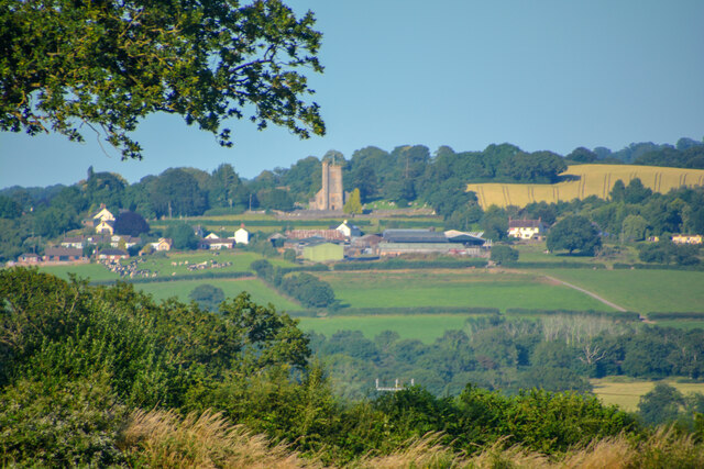
Gipsy Town is a small village located in the county of Devon, England. Situated in the South West region of the country, it is nestled within the picturesque countryside and offers a tranquil and idyllic setting for its residents.

The village is home to a close-knit community, known for its friendly and welcoming atmosphere. The population is relatively small, with around 500 residents, allowing for a tight sense of community and a strong feeling of belonging.

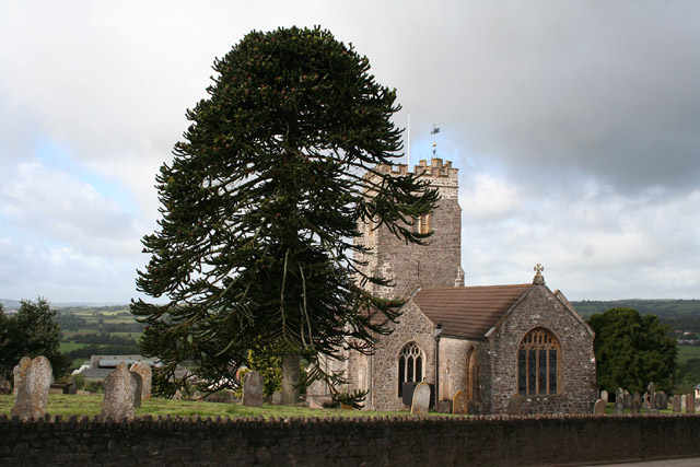
Gipsy Town boasts a rich history, with records dating back to medieval times. The village has managed to retain its traditional charm, with many of its buildings and houses maintaining their original architecture. The local church, St. Mary's, is a prominent feature of the village and showcases stunning examples of medieval craftsmanship.

Surrounded by lush green fields and rolling hills, Gipsy Town offers ample opportunities for outdoor activities. Residents and visitors alike can enjoy scenic walks, cycling, and horse riding in the nearby countryside. The village is also located close to the beautiful Devon coastline, providing easy access to stunning beaches and coastal walks.

While Gipsy Town is primarily a residential area, there are a few amenities available for its residents. A small village shop provides essential groceries, and there is a cozy pub offering a place for locals to gather and socialize.

Overall, Gipsy Town is a delightful village in Devon that offers a peaceful and charming lifestyle in a beautiful countryside setting.

If you have any feedback on the listing, please let us know in the comments section below.

Gipsy Town Images

Images are sourced within 2km of 50.933735/-3.303401 or Grid Reference ST0815. Thanks to Geograph Open Source API. All images are credited.

Black Bridge Carried a mineral railway serving Westleigh Quarry. Now carries a footpath.
The railway replaced a tramway in 1892.
Black Bridge
Carried a mineral railway serving Westleigh Quarry. Now carries a footpath. The railway replaced a tramway in 1892.
Grass field near Burlescombe The M5 visible in the valley below.
Grass field near Burlescombe
The M5 visible in the valley below.
Sampford Peverell : Countryside Scenery Looking towards Burlescombe.
Sampford Peverell : Countryside Scenery
Looking towards Burlescombe.
Burlescombe : The A38 Traffic on the A38.
Burlescombe : The A38
Traffic on the A38.
Burlescombe : The A38 Looking along the A38.
Burlescombe : The A38
Looking along the A38.
Burlescombe : The M5 Motorway Looking along the M5.
Burlescombe : The M5 Motorway
Looking along the M5.
Burlescombe : Grand Western Canal - Black Bridge Black Bridge is an old mineral line bridge across which limestone was transported to the railway line further up in the village.
Burlescombe : Grand Western Canal - Black Bridge
Black Bridge is an old mineral line bridge across which limestone was transported to the railway line further up in the village.
Burlescombe : Grand Western Canal - Black Bridge Crossing Black Bridge.
Burlescombe : Grand Western Canal - Black Bridge
Crossing Black Bridge.
Burlescombe : Grand Western Canal Looking along the canal.
Burlescombe : Grand Western Canal
Looking along the canal.
Grand Western Canal Sluice gate on the canal.
Grand Western Canal
Sluice gate on the canal.
Disused Railway Bridge Bridge over the Grand Western Canal.
Disused Railway Bridge
Bridge over the Grand Western Canal.
St Mary's Church Church at Burlescombe.
St Mary's Church
Church at Burlescombe.
The A38 heading north-east uphill
The A38 at Southdown Cross, heading north-east
The A38, heading north-east
The M5 seen from the A38 overbridge
Chesterfield House, used to be The Poacher's Pocket, on the A38
Field near Burlescombe
Show me another place!

Gipsy Town is located at Grid Ref: ST0815 (Lat: 50.933735, Lng: -3.303401)

Administrative County: Devon

District: Mid Devon

Police Authority: Devon and Cornwall

What 3 Words

///misty.penny.depravity. Near Uffculme, Devon

Related Wikis

Culmstock

Culmstock is a village and civil parish in Mid Devon, England, centred 10 miles from Tiverton and 6 NE of Cullompton. It is laid out on both sides of the...

Burlescombe

Burlescombe (, bur-LES-kəm) is a village and civil parish in the Mid Devon district of Devon, England. The parish is surrounded, clockwise from the north...

Appledore, Mid Devon

Appledore is a small village near Uffculme in Devon, England, about 7 miles (11 kilometres) east of Tiverton.Appledore was listed in the Domesday Book...

Canonsleigh Abbey

Canonsleigh Abbey was an Augustinian priory in the parish of Burlescombe, Devon. == History == It was founded in about 1170 by Walter de Claville, lord...

Culmstock Halt railway station

Culmstock Halt railway station served the village of Culmstock, Devon, England, from 1876 to 1963 on the Culm Valley Light Railway. == History == The station...

Wellington Bank, Somerset

Wellington Bank is a steep railway embankment and associated climb located on the Bristol to Exeter line, that climbs from just northeast of Wellington...

Black Down and Sampford Commons

Black Down and Sampford Commons (grid reference ST118161) is a 155.2-hectare (384-acre) biological Site of Special Scientific Interest in Devon and Somerset...

Sampford Arundel

Sampford Arundel is a village and civil parish in Somerset, England. It is situated near Wellington and 10 miles (16.1 km) south west of Taunton. The village...

Nearby Amenities

Located within 500m of 50.933735,-3.303401
Maidenhead Cross
Junction: yes
Lat/Long: 50.9357312/-3.3067774
Phone
Emergency: phone
Operator: National Highways
Operator Type: government
Operator Wikidata: Q5760006
Lat/Long: 50.9371003/-3.3069446
Phone
Emergency: phone
Operator: National Highways
Operator Type: government
Operator Wikidata: Q5760006
Lat/Long: 50.9373652/-3.3070593
Generator Method: photovoltaic
Generator Output Electricity: yes
Generator Source: solar
Generator Type: solar_photovoltaic_panel
Location: ground
Power: generator
Lat/Long: 50.9315833/-3.3000746
Generator Method: photovoltaic
Generator Output Electricity: yes
Generator Source: solar
Generator Type: solar_photovoltaic_panel
Location: ground
Power: generator
Lat/Long: 50.9315714/-3.2996616
Generator Method: photovoltaic
Generator Output Electricity: yes
Generator Source: solar
Generator Type: solar_photovoltaic_panel
Location: ground
Power: generator
Lat/Long: 50.9314176/-3.2994363
Generator Method: photovoltaic
Generator Output Electricity: yes
Generator Source: solar
Generator Type: solar_photovoltaic_panel
Location: ground
Power: generator
Lat/Long: 50.9310153/-3.2996804
Generator Method: photovoltaic
Generator Output Electricity: yes
Generator Source: solar
Generator Type: solar_photovoltaic_panel
Location: roof
Power: generator
Lat/Long: 50.9317084/-3.2985351
Power: pole
Source: bing
Transformer: distribution
Lat/Long: 50.9344054/-3.3030787
Power: pole
Source: bing
Lat/Long: 50.9340952/-3.3012588
Power: pole
Source: bing
Lat/Long: 50.9329593/-3.2986531
The data included in this document is from www.openstreetmap.org. The data is made available under ODbL.

Have you been to Gipsy Town?

Leave your review of Gipsy Town below (or comments, questions and feedback).