Felldownhead

Settlement in Devon West Devon

England

Felldownhead

Bradstone Manor Gatehouse An impressive late 16th century gatehouse <span class="nowrap"><a title="https://historicengland.org.uk/listing/the-list/list-entry/1104827?section=official-list-entry" rel="nofollow ugc noopener" href="https://historicengland.org.uk/listing/the-list/list-entry/1104827?section=official-list-entry">Link</a><img style="margin-left:2px;" alt="External link" title="External link - shift click to open in new window" src="https://s1.geograph.org.uk/img/external.png" width="10" height="10"/></span>
Bradstone Manor Gatehouse Credit: Sandy Gerrard

Felldownhead is a small village located in the county of Devon, England. Situated on the southern edge of Dartmoor National Park, it is surrounded by picturesque rolling hills and lush green countryside. The village is home to around 300 residents and has a quaint and peaceful atmosphere.

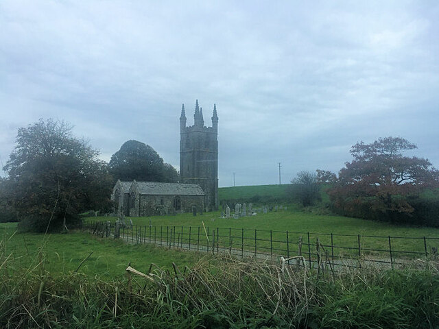
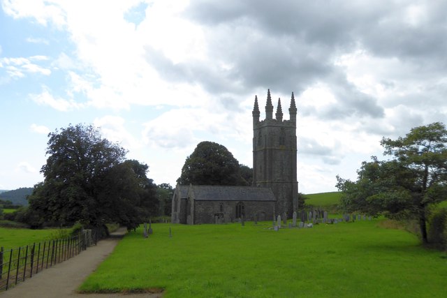
The history of Felldownhead can be traced back centuries, with evidence of Roman and medieval settlements in the area. Today, the village retains its traditional charm with a mix of historic buildings and modern amenities. The local church, St. Mary's, is a prominent landmark and dates back to the 13th century.

Nature lovers are drawn to Felldownhead due to its proximity to Dartmoor National Park. The park offers a wealth of outdoor activities, including hiking, cycling, and wildlife spotting. The rugged landscapes of Dartmoor provide a stunning backdrop for exploring its many tors, ancient stone circles, and picturesque villages.

Felldownhead itself offers a range of amenities for residents and visitors. There is a village shop, a pub serving traditional English fare, and a community center that hosts events and activities throughout the year. The village also benefits from good transport links, with regular bus services connecting it to nearby towns and cities.

Overall, Felldownhead is a charming village nestled in the heart of Devon's countryside. Its natural beauty, rich history, and welcoming community make it an attractive destination for those seeking a peaceful retreat or a base for exploring the surrounding area.

If you have any feedback on the listing, please let us know in the comments section below.

Felldownhead Images

Images are sourced within 2km of 50.598091/-4.2945117 or Grid Reference SX3780. Thanks to Geograph Open Source API. All images are credited.

Bradstone Manor Gatehouse An impressive late 16th century gatehouse <span class="nowrap"><a title="https://historicengland.org.uk/listing/the-list/list-entry/1104827?section=official-list-entry" rel="nofollow ugc noopener" href="https://historicengland.org.uk/listing/the-list/list-entry/1104827?section=official-list-entry">Link</a><img style="margin-left:2px;" alt="External link" title="External link - shift click to open in new window" src="https://s1.geograph.org.uk/img/external.png" width="10" height="10"/></span>
Bradstone Manor Gatehouse
An impressive late 16th century gatehouse LinkExternal link
All Saints Church
All Saints Church
Eastacott Barton The farm and climbing centre, seen from the B3362.  The farmhouse, the white building at the left, is just in <a href="https://www.geograph.org.uk/gridref/SX3879">SX3879</a>
Eastacott Barton
The farm and climbing centre, seen from the B3362. The farmhouse, the white building at the left, is just in SX3879
Turning for climbing centre at Eastacott
Junction on B3362 for Bradstone
Dunterton Church All Saints Church, Dunterton is isolated from houses.  There are cottages and a farm to the east, on the site of the manor house, and the parish once boasted its own rectory, on the hill to the north
Dunterton Church
All Saints Church, Dunterton is isolated from houses. There are cottages and a farm to the east, on the site of the manor house, and the parish once boasted its own rectory, on the hill to the north
The isolation of Dunterton Church The woods on the left mark the site of a former quarry
The isolation of Dunterton Church
The woods on the left mark the site of a former quarry
Dunterton Church All Saints Church, Dunterton (listed Grade I) is isolated; its parish extended to include several hamlets; even so, in the 1870s there were only 35 houses in the parish
Dunterton Church
All Saints Church, Dunterton (listed Grade I) is isolated; its parish extended to include several hamlets; even so, in the 1870s there were only 35 houses in the parish
Access road to Hardstone Farm
B3362 entering a tunnel-like wood Hardstone Wood borders the Tamar. There is a sudden transition from light to the darkness of the overhanging trees
B3362 entering a tunnel-like wood
Hardstone Wood borders the Tamar. There is a sudden transition from light to the darkness of the overhanging trees
Pond Cottage in the grounds of Endsleigh Cottage One of the buildings surrounding the cottage orne of the Duke of Bedford (picture is a scan from a colour slide)
Pond Cottage in the grounds of Endsleigh Cottage
One of the buildings surrounding the cottage orne of the Duke of Bedford (picture is a scan from a colour slide)
House by Greystone Bridge A former tollhouse close to the bridge across the Tamar
House by Greystone Bridge
A former tollhouse close to the bridge across the Tamar
Greystone Bridge This  arch bridge is grade I listed.  Dating back to 1439, it was built with money raised by Bishop Lacey.  The name is derived from the grey stone found locally (and still quarried at Greystone Quarry)
Greystone Bridge
This arch bridge is grade I listed. Dating back to 1439, it was built with money raised by Bishop Lacey. The name is derived from the grey stone found locally (and still quarried at Greystone Quarry)
River Tamar below Greystone Bridge
Car park area in Greystone Quarry
The final crushing plant at Greystone Quarry This quarry produces material for road surfacing.  This plant produces stones of under 10mm and the products are used for roads in Cornwall, Devon and as far east as the Isle of Wight
The final crushing plant at Greystone Quarry
This quarry produces material for road surfacing. This plant produces stones of under 10mm and the products are used for roads in Cornwall, Devon and as far east as the Isle of Wight
Offices and weighbridge at Greystone Quarry
Heaps of waste material in Greystone Quarry Some of these heaps are being reworked to look for usable material
Heaps of waste material in Greystone Quarry
Some of these heaps are being reworked to look for usable material
Show me another place!

Felldownhead is located at Grid Ref: SX3780 (Lat: 50.598091, Lng: -4.2945117)

Administrative County: Devon

District: West Devon

Police Authority: Devon and Cornwall

What 3 Words

///bleak.soonest.cheaply. Near Lifton, Devon

Nearby Locations

Felldownhead

Related Wikis

Dunterton

Dunterton is a civil parish and small village in the Tavistock district in the county of Devon, England. The parish was mentioned in the Domesday Book...

Church of St Nonna, Bradstone

The Church of St Nonna is a redundant church in Bradstone, Devon, England that was built in the 12th century. It is recorded in the National Heritage List...

Bradstone

Bradstone is a village in Devon, England, on the River Tamar. It has a small church and a Tudor hall (now a farm) with an attractive gatehouse. Bradstone...

Castle Head, Devon

Castle Head is a British Iron Age Hill fort occupying a commanding position on a promontory at the neck of a bow in the River Tamar on the Devon side close...

Nearby Amenities

Located within 500m of 50.598091,-4.2945117
Felldownhead
Place: hamlet
Lat/Long: 50.5983069/-4.2942091
Countryman Cider
Shop: alcohol
Lat/Long: 50.598213/-4.2946731
Post Box
Brand: Royal Mail
Brand Wikidata: Q638098
Brand Wikipedia: en:Royal Mail
Collection Times: Mo-Sa 10:00; Su off
Operator: Royal Mail
Operator Wikidata: Q638098
Post Box Design: type_c
Post Box Mounting: building
Post Box Type: wall
Ref: PL19 4
Royal Cypher: VR
Royal Cypher Wikidata: Q33102356
Source: survey;streetlevel imagery;aerial imagery
Lat/Long: 50.5982139/-4.2945122
The data included in this document is from www.openstreetmap.org. The data is made available under ODbL.

Have you been to Felldownhead?

Leave your review of Felldownhead below (or comments, questions and feedback).