Feabuie

Settlement in Nairnshire

Scotland

Feabuie

Cumberland's Stone Upon this boulder the Duke of Cumberland is supposed to have surveyed the progress of the Battle of Culloden. Geologically it is an erratic from the last ice age.
Cumberland's Stone Credit: David Bremner

Feabuie is a small village located in the Highland region of Scotland, specifically in the county of Nairnshire. Situated approximately 4 miles southeast of the town of Nairn, Feabuie is surrounded by picturesque countryside and offers a tranquil and scenic setting.

The village itself is home to a close-knit community, with a population of around 200 residents. The majority of the village's buildings are traditional stone houses, giving Feabuie a charming and timeless feel.

Although small in size, Feabuie benefits from its proximity to the nearby town of Nairn, which provides amenities such as shops, supermarkets, and schools. This allows residents to enjoy the peacefulness of village life while having convenient access to essential services.

In terms of natural attractions, Feabuie is located near the beautiful Moray Firth coastline. This provides locals and visitors with opportunities to explore stunning beaches, participate in water sports, or simply enjoy long walks along the shore.

For those interested in history, nearby attractions include the Cawdor Castle and Brodie Castle, both of which are renowned for their architectural beauty and historical significance.

Overall, Feabuie offers a serene and idyllic place to live, surrounded by breathtaking landscapes and with easy access to nearby amenities. Its close-knit community and proximity to stunning coastal areas make it an attractive destination for those seeking a peaceful and picturesque lifestyle in the Scottish Highlands.

If you have any feedback on the listing, please let us know in the comments section below.

Feabuie Images

Images are sourced within 2km of 57.493108/-4.0837262 or Grid Reference NH7546. Thanks to Geograph Open Source API. All images are credited.

Cumberland's Stone Upon this boulder the Duke of Cumberland is supposed to have surveyed the progress of the Battle of Culloden. Geologically it is an erratic from the last ice age.
Cumberland's Stone
Upon this boulder the Duke of Cumberland is supposed to have surveyed the progress of the Battle of Culloden. Geologically it is an erratic from the last ice age.
Post Box at Balloch IV2 36. Royal Mail list this box as 'Balloch Village'.
Post Box at Balloch
IV2 36. Royal Mail list this box as 'Balloch Village'.
Interior of an Azuma first class carriage Grey is the colour - mostly! On the 'Highland Chieftain' route from King's Cross to Inverness.
Interior of an Azuma first class carriage
Grey is the colour - mostly! On the 'Highland Chieftain' route from King's Cross to Inverness.
Old Leanach Cottage, Culloden Battlefield The Culloden Battlefield on a bright winter day.
Old Leanach Cottage, Culloden Battlefield
The Culloden Battlefield on a bright winter day.
Government line markers for the Battle of Culloden Beside the battlefield is an area where dogs are welcomed and many come to walk.  There was a bitter wind this day and the cafeteria at the National Trust for Scotland Visitor Centre was a boon.  For potential visitors, entry to the battlefield is free.  The entrance fee you pay at the Visitor Centre is for exploring the Visitor Centre alone.  The battlefield is available to all.
Government line markers for the Battle of Culloden
Beside the battlefield is an area where dogs are welcomed and many come to walk. There was a bitter wind this day and the cafeteria at the National Trust for Scotland Visitor Centre was a boon. For potential visitors, entry to the battlefield is free. The entrance fee you pay at the Visitor Centre is for exploring the Visitor Centre alone. The battlefield is available to all.
Forest path, Culloden
Forestry track junction in High Wood, Culloden Forest
Forestry road, Culloden Forest
Farmland near Leanach Agricultural land near Culloden.
Farmland near Leanach
Agricultural land near Culloden.
Piper at Culloden Piper demonstrating bagpipes outside the Visitor Centre at the Culloden Battlefield.
Piper at Culloden
Piper demonstrating bagpipes outside the Visitor Centre at the Culloden Battlefield.
Old Leanach Cottage, Culloden Battlefield Leanach cottage on the grounds of Culloden Battlefield was probably constructed in the early 18th century. It is one of the last survivors of a type of a single-storey thatched building which were once common in these parts. In the past, this area was well-populated and the land divided into smallholdings but Leanach is now one of the only surviving examples of this landscape.

During the Battle of Culloden, Leanach Cottage was situated in between the Government lines and it is likely the building would have been used as a field hospital for the government men.

Following Culloden, occupation of the cottage was intermittent and fell into a ruinous state from around the late 1860s; it was rebuilt and reoccupied in the early 1880s. The last occupant of Leanach Cottage died in 1912.  The cottage was gifted to the National Trust for Scotland in 1944 and it became the original battlefield visitor centre in 1961. 

<span class="nowrap"><a title="https://cullodenbattlefield.wordpress.com/2015/10/02/leanach-cottage/" rel="nofollow ugc noopener" href="https://cullodenbattlefield.wordpress.com/2015/10/02/leanach-cottage/">Link</a><img style="margin-left:2px;" alt="External link" title="External link - shift click to open in new window" src="https://s1.geograph.org.uk/img/external.png" width="10" height="10"/></span>  Culloden Battlefield
Old Leanach Cottage, Culloden Battlefield
Leanach cottage on the grounds of Culloden Battlefield was probably constructed in the early 18th century. It is one of the last survivors of a type of a single-storey thatched building which were once common in these parts. In the past, this area was well-populated and the land divided into smallholdings but Leanach is now one of the only surviving examples of this landscape. During the Battle of Culloden, Leanach Cottage was situated in between the Government lines and it is likely the building would have been used as a field hospital for the government men. Following Culloden, occupation of the cottage was intermittent and fell into a ruinous state from around the late 1860s; it was rebuilt and reoccupied in the early 1880s. The last occupant of Leanach Cottage died in 1912. The cottage was gifted to the National Trust for Scotland in 1944 and it became the original battlefield visitor centre in 1961. LinkExternal link Culloden Battlefield
Memorial Cairn, Culloden Battlefield The memorial cairn is probably the most widely recognised feature on the battlefield. It was erected by Duncan Forbes in 1881 and stands 6 metres tall. The protective railings which surrounded the cairn when I visited in 1978 (<a href="https://www.geograph.org.uk/photo/2345956">NH7444 : Memorial Cairn, Culloden Battlefield.</a>) have since been removed.

See also <a href="https://www.geograph.org.uk/photo/7212018">NH7444 : Inscription on Culloden Battlefield Memorial</a>
Memorial Cairn, Culloden Battlefield
The memorial cairn is probably the most widely recognised feature on the battlefield. It was erected by Duncan Forbes in 1881 and stands 6 metres tall. The protective railings which surrounded the cairn when I visited in 1978 (NH7444 : Memorial Cairn, Culloden Battlefield.) have since been removed. See also NH7444 : Inscription on Culloden Battlefield Memorial
Inscription on Culloden Battlefield Memorial Inscription on <a href="https://www.geograph.org.uk/photo/7212000">NH7444 : Memorial Cairn, Culloden Battlefield</a>

THE BATTLE OF CULLODEN
WAS FOUGHT ON THIS MOOR 
16th APRIL 1746
________________
THE GRAVES OF THE
GALLANT HIGHLANDERS 
WHO FOUGHT FOR
SCOTLAND & PRINCE CHARLIE
ARE MARKED BY THE NAMES OF THEIR CLANS
Inscription on Culloden Battlefield Memorial
Inscription on NH7444 : Memorial Cairn, Culloden Battlefield THE BATTLE OF CULLODEN WAS FOUGHT ON THIS MOOR 16th APRIL 1746 ________________ THE GRAVES OF THE GALLANT HIGHLANDERS WHO FOUGHT FOR SCOTLAND & PRINCE CHARLIE ARE MARKED BY THE NAMES OF THEIR CLANS
Graves of the Clans, Culloden Battlefield In 1881, Duncan Forbes erected a memorial cairn (<a href="https://www.geograph.org.uk/photo/7212000">NH7444 : Memorial Cairn, Culloden Battlefield</a>) on the site of the battle. He also erected a series of headstones which bear the names of the clans that fought here. They mark the mass graves where the fallen Jacobite rebels were buried by local people after the battle.
Graves of the Clans, Culloden Battlefield
In 1881, Duncan Forbes erected a memorial cairn (NH7444 : Memorial Cairn, Culloden Battlefield) on the site of the battle. He also erected a series of headstones which bear the names of the clans that fought here. They mark the mass graves where the fallen Jacobite rebels were buried by local people after the battle.
Battle Lines at Culloden The lines of the troops at the Battle of Culloden are marked with red and blue flags. The red flags mark the line of the government troops whilst blue flags mark the line of the Jacobite troops before the charge.

When the Highland charge <span class="nowrap"><a title="https://en.wikipedia.org/wiki/Highland_charge" rel="nofollow ugc noopener" href="https://en.wikipedia.org/wiki/Highland_charge">Link</a><img style="margin-left:2px;" alt="External link" title="External link - shift click to open in new window" src="https://s1.geograph.org.uk/img/external.png" width="10" height="10"/></span>  began, the right flank was able to move quickly but the middle and left were slowed down by boggy conditions underfoot. Today the ground is much drier than it would have been in the eighteenth century, having been drained by forestry and farming over the years. The National Trust for Scotland is gradually working to return the land to a condition resembling how it would have looked at the time of the battle.
Battle Lines at Culloden
The lines of the troops at the Battle of Culloden are marked with red and blue flags. The red flags mark the line of the government troops whilst blue flags mark the line of the Jacobite troops before the charge. When the Highland charge LinkExternal link began, the right flank was able to move quickly but the middle and left were slowed down by boggy conditions underfoot. Today the ground is much drier than it would have been in the eighteenth century, having been drained by forestry and farming over the years. The National Trust for Scotland is gradually working to return the land to a condition resembling how it would have looked at the time of the battle.
Bus Stop on the B9006, Newlands of Culloden SV12 AYW, Stagecoach Highlands' Scania K230UB/Alexander Dennis Enviro 300, at the bus stop near the Culloden Moor Caravan and Motorhome Club campsite.
Bus Stop on the B9006, Newlands of Culloden
SV12 AYW, Stagecoach Highlands' Scania K230UB/Alexander Dennis Enviro 300, at the bus stop near the Culloden Moor Caravan and Motorhome Club campsite.
Bridge over the Railway at Newlands of Culloden
Show me another place!

Feabuie is located at Grid Ref: NH7546 (Lat: 57.493108, Lng: -4.0837262)

Unitary Authority: Highland

Police Authority: Highlands and Islands

What 3 Words

///lower.contained.tedious. Near Balloch, Highland

Nearby Locations

Feabuie

Related Wikis

Balloch, Highland

Balloch (; Scottish Gaelic: Baile an Locha, IPA:[ˈpaləˈanˈɫ̪ɔxə]) is a residential village four miles (6.4 km) east of the city of Inverness, Scotland...

Culloden Moor railway station

Culloden Moor railway station served the village of Culloden, Highland, Scotland from 1898 to 1965 on the Inverness and Aviemore Direct Railway. ��2�...

Battle of Culloden

The Battle of Culloden (; Scottish Gaelic: Blàr Chùil Lodair) was the final confrontation of the Jacobite rising of 1745. On 16 April 1746, the Jacobite...
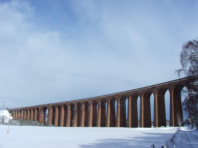
Culloden Viaduct

The Culloden Viaduct is a railway viaduct on the Highland Main Line, to the east of the city of Inverness, in the Highland council area of Scotland. It...

Clava cairn

The Clava cairn is a type of Bronze Age circular chamber tomb cairn, named after the group of three cairns at Balnuaran of Clava, to the east of Inverness...

Castle Stuart Platform railway station

Castle Stuart Platform was a railway station located near Castle Stuart, to the east of Inverness, now in Highland council area. Opened in 1855 to serve...

Culloden Academy

Culloden Academy (Scottish Gaelic: Acadamaidh Cùil Lodair) is a non-denominational secondary school in Culloden, Highland, Scotland. The present enrollment...

Culloden, Highland

Culloden ( ; from Scottish Gaelic Cùl Lodain, "back of the small pond"; modern Gaelic Cùil Lodair) is the name of a village three miles (five kilometres...

Nearby Amenities

Located within 500m of 57.493108,-4.0837262
Power: pole
Lat/Long: 57.4902362/-4.0884849
Power: pole
Lat/Long: 57.4905177/-4.0873194
Power: pole
Lat/Long: 57.4907882/-4.0861675
Power: pole
Lat/Long: 57.4911818/-4.0845576
Power: pole
Lat/Long: 57.4914621/-4.0833899
Material: wood
Power: pole
Lat/Long: 57.4917473/-4.0821926
Material: wood
Power: pole
Lat/Long: 57.4919678/-4.0812811
Material: wood
Power: pole
Lat/Long: 57.4921811/-4.0803582
Material: wood
Power: pole
Lat/Long: 57.4923675/-4.0800703
Material: wood
Power: pole
Lat/Long: 57.4928537/-4.079186
Material: wood
Power: pole
Lat/Long: 57.4933655/-4.0782722
Material: wood
Power: pole
Lat/Long: 57.4938883/-4.0773697
Power: pole
Lat/Long: 57.4944025/-4.0764423
Power: pole
Lat/Long: 57.4895233/-4.088689
Power: pole
Lat/Long: 57.489477/-4.0879271
Power: pole
Lat/Long: 57.4894294/-4.0871698
Power: pole
Lat/Long: 57.489338/-4.0857412
The data included in this document is from www.openstreetmap.org. The data is made available under ODbL.

Have you been to Feabuie?

Leave your review of Feabuie below (or comments, questions and feedback).