Fairhaven

Settlement in Lancashire Fylde

England

Fairhaven

Ansdell foreshore, near to Lytham St. Anne's Here the photographer had his back to Fairhaven Lake.
Over the houses the iconic 'White Church' <span class="nowrap"><a title="http://www.findachurch.co.uk/churches/sd/sd32/whitechurch/" rel="nofollow ugc noopener" href="http://www.findachurch.co.uk/churches/sd/sd32/whitechurch/">Link</a><img style="margin-left:2px;" alt="External link" title="External link - shift click to open in new window" src="https://s1.geograph.org.uk/img/external.png" width="10" height="10"/></span> reaches up for a view of the sand-banks of the Ribble Estuary.
Ansdell foreshore, near to Lytham St. Anne's Credit: Geoff Royle

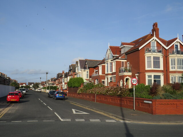
Fairhaven is a small coastal village located in the district of Fylde, Lancashire, England. Situated on the Fylde Coast, it lies approximately 4 miles south of Blackpool and 8 miles northwest of Preston. The village is part of the larger town of Lytham St Annes and is known for its picturesque surroundings.

Fairhaven is primarily a residential area, characterized by beautiful Victorian and Edwardian houses, many of which are set within spacious gardens. The village is renowned for its peaceful atmosphere, making it an attractive place for those seeking a tranquil lifestyle away from the bustling city centers.

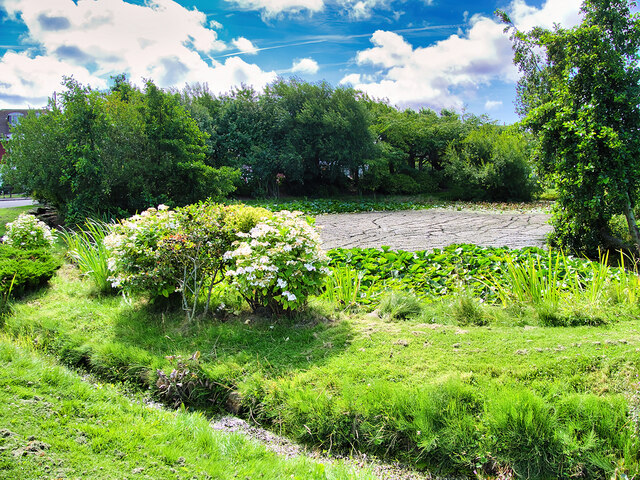
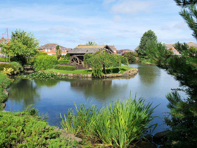
The village is also home to Fairhaven Lake, a popular local attraction. The lake covers an area of 70 acres and is surrounded by landscaped gardens and woodland, providing a serene environment for walking, picnicking, and bird watching. There is a boating lake where visitors can hire rowing boats and pedalos, adding to the recreational opportunities available.

Fairhaven also benefits from its proximity to nearby amenities. The neighboring town of Lytham St Annes offers a range of shops, restaurants, and leisure facilities, including several golf courses. The sandy beaches of the Fylde Coast are just a short stroll away, allowing residents to enjoy coastal walks and the fresh sea air.

Overall, Fairhaven is a charming village that offers a quiet and idyllic setting for its residents, with easy access to nearby amenities and the natural beauty of the Fylde Coast.

If you have any feedback on the listing, please let us know in the comments section below.

Fairhaven Images

Images are sourced within 2km of 53.738693/-2.9950912 or Grid Reference SD3427. Thanks to Geograph Open Source API. All images are credited.

Ansdell foreshore, near to Lytham St. Anne's Here the photographer had his back to Fairhaven Lake.
Over the houses the iconic 'White Church' <span class="nowrap"><a title="http://www.findachurch.co.uk/churches/sd/sd32/whitechurch/" rel="nofollow ugc noopener" href="http://www.findachurch.co.uk/churches/sd/sd32/whitechurch/">Link</a><img style="margin-left:2px;" alt="External link" title="External link - shift click to open in new window" src="https://s1.geograph.org.uk/img/external.png" width="10" height="10"/></span> reaches up for a view of the sand-banks of the Ribble Estuary.
Ansdell foreshore, near to Lytham St. Anne's
Here the photographer had his back to Fairhaven Lake. Over the houses the iconic 'White Church' LinkExternal link reaches up for a view of the sand-banks of the Ribble Estuary.
Lightburne Avenue, St. Anne's-on-the-Sea Lightburne Avenue is a residential road near the seafront at St. Anne's-on-the-Sea, on the Lancashire coast.
Lightburne Avenue, St. Anne's-on-the-Sea
Lightburne Avenue is a residential road near the seafront at St. Anne's-on-the-Sea, on the Lancashire coast.
Green space by the sea, St. Anne's-on-the-Sea A green space between houses on South Promenade and the seafront at St. Anne's-on-the-Sea.
Green space by the sea, St. Anne's-on-the-Sea
A green space between houses on South Promenade and the seafront at St. Anne's-on-the-Sea.
Watching the trains go by In the course of taking a few snaps from a train on the way to Blackpool, I happened to catch this lad sitting on a fence at a pedestrian crossing of the railway. Scenes like this are timeless (apart from changing fashions).
Watching the trains go by
In the course of taking a few snaps from a train on the way to Blackpool, I happened to catch this lad sitting on a fence at a pedestrian crossing of the railway. Scenes like this are timeless (apart from changing fashions).
Lytham Hall (1) This was taken at the inner gates at Lytham Hall, Lytham St Anne's, Lancashire. Surrounded by its own woodland, Lytham Hall is a Grade I listed Georgian country house on land owned by the Clifton family since the early 17th century.
Lytham Hall (1)
This was taken at the inner gates at Lytham Hall, Lytham St Anne's, Lancashire. Surrounded by its own woodland, Lytham Hall is a Grade I listed Georgian country house on land owned by the Clifton family since the early 17th century.
To the formal garden, Lytham Hall I am on the edge of the woodland ranging to the south of Lytham Hall and looking northwards through the treeline towards the formal garden. Lytham St Anne's, Lancashire.
To the formal garden, Lytham Hall
I am on the edge of the woodland ranging to the south of Lytham Hall and looking northwards through the treeline towards the formal garden. Lytham St Anne's, Lancashire.
Curtains Pond This is Curtains Pond, located to the south west of the grounds at Lytham Hall, Lytham St Anne's, Lancashire. I am standing on the east side of the pond and the housing estate off Forest Drive can be glimpsed through the treeline.
Curtains Pond
This is Curtains Pond, located to the south west of the grounds at Lytham Hall, Lytham St Anne's, Lancashire. I am standing on the east side of the pond and the housing estate off Forest Drive can be glimpsed through the treeline.
Paradise Wall This is taken at the northern end of the Paradise Wall at Lytham Hall, built in the late 17th/early 18th century to shelter the garden from blown sand and screen the grounds from the main Heyhouses Road.
Paradise Wall
This is taken at the northern end of the Paradise Wall at Lytham Hall, built in the late 17th/early 18th century to shelter the garden from blown sand and screen the grounds from the main Heyhouses Road.
Lytham Hall (2) This is the west entrance to Lytham Hall, Lytham St Anne's, Lancashire. The main entrance faces north around the corner. The estate amenities (including café and retail) are located just beyond the north entrance as are the main Hall woods.
Lytham Hall (2)
This is the west entrance to Lytham Hall, Lytham St Anne's, Lancashire. The main entrance faces north around the corner. The estate amenities (including café and retail) are located just beyond the north entrance as are the main Hall woods.
The Shrimper The life-size bronze figure of a traditional nineteenth century shrimper by sculptor Colin Spofforth was commissioned as part of a heritage lottery project for the Lowther Gardens in Royal Lytham St Anne’s. It was unveiled in November 2003 <span class="nowrap"><a title="http://www.colinspofforth.com/projects/index.php?s=the-lytham-shrimper" rel="nofollow ugc noopener" href="http://www.colinspofforth.com/projects/index.php?s=the-lytham-shrimper">Link</a><img style="margin-left:2px;" alt="External link" title="External link - shift click to open in new window" src="https://s1.geograph.org.uk/img/external.png" width="10" height="10"/></span> (Colin Spofforth Studio).
The Shrimper
The life-size bronze figure of a traditional nineteenth century shrimper by sculptor Colin Spofforth was commissioned as part of a heritage lottery project for the Lowther Gardens in Royal Lytham St Anne’s. It was unveiled in November 2003 LinkExternal link (Colin Spofforth Studio).
St Joseph's RC Church, Ansdell Large Roman Catholic Church on Woodlands Road, dated 1911 on the north gable wall. Grade II listed building (List Entry 1219459 <span class="nowrap"><a title="https://historicengland.org.uk/listing/the-list/list-entry/1219459?section=official-list-entry" rel="nofollow ugc noopener" href="https://historicengland.org.uk/listing/the-list/list-entry/1219459?section=official-list-entry">Link</a><img style="margin-left:2px;" alt="External link" title="External link - shift click to open in new window" src="https://s1.geograph.org.uk/img/external.png" width="10" height="10"/></span> Historic England).
St Joseph's RC Church, Ansdell
Large Roman Catholic Church on Woodlands Road, dated 1911 on the north gable wall. Grade II listed building (List Entry 1219459 LinkExternal link Historic England).
Blackpool Road, Ansdell
Cypress Point, Stream alongside Dunlin Drive Part of a prestigious housing development at Lytham St Annes.
Cypress Point, Stream alongside Dunlin Drive
Part of a prestigious housing development at Lytham St Annes.
The Northern end of the Village Green at Cypress Point
Pond on the Village Green at Cypress Point
Cypress Point Village Green
Children of Cypress Point One of a series of life-size, bronze sculptures commissioned from sculptor Colin Spofforth by the developers of Cypress Point in 1999 <span class="nowrap"><a title="http://www.colinspofforth.com/projects/index.php?s=the-children-of-cypress-point" rel="nofollow ugc noopener" href="http://www.colinspofforth.com/projects/index.php?s=the-children-of-cypress-point">Link</a><img style="margin-left:2px;" alt="External link" title="External link - shift click to open in new window" src="https://s1.geograph.org.uk/img/external.png" width="10" height="10"/></span> (Colin Spofforth Studio).
Children of Cypress Point
One of a series of life-size, bronze sculptures commissioned from sculptor Colin Spofforth by the developers of Cypress Point in 1999 LinkExternal link (Colin Spofforth Studio).
Bowling Greens The bowling greens at Lowther Gardens, Lytham St Anne's, Lancashire.
Bowling Greens
The bowling greens at Lowther Gardens, Lytham St Anne's, Lancashire.
Show me another place!

Fairhaven is located at Grid Ref: SD3427 (Lat: 53.738693, Lng: -2.9950912)

Administrative County: Lancashire

District: Fylde

Police Authority: Lancashire

What 3 Words

///shave.uttering.ombudsman. Near Lytham St Annes, Lancashire

Related Wikis

Ansdell & Fairhaven railway station

Ansdell and Fairhaven railway station is on the Blackpool South to Preston railway line in Lancashire, England. In the past, it has also been known as...

Woodlands Memorial Ground

Woodlands Memorial Ground is a rugby stadium in Lytham St Annes, Lancashire, England. It is the home of Fylde Rugby Club and was the home of the Blackpool...

Lytham St Annes High School

LSA High School is a community school maintained by Lancashire County Education Authority. It is an 11–16 Comprehensive. == History == 1955 Ansdell County...

King Edward VII and Queen Mary School

King Edward VII and Queen Mary School (KEQMS) was an HMC independent co-educational school in Lytham St Annes, Lancashire, England, formed in 2000 by the...

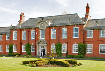
King Edward VII School, Lytham

King Edward VII School (KES) or King Edward School Lytham was a grammar, direct grant grammar and independent school for boys, founded in 1908 and situated...

AKS Lytham

AKS Lytham (AKS), or ArnoldKEQMS, is an independent, co-educational day school located on the Fylde, Lancashire, England. It was formed from the merger...

Lytham rail crash

The derailment of a passenger train at Lytham, Lancashire, England occurred when the front tyre of the locomotive fractured. The crash caused the loss...

Lifeboat Memorial, Lytham

The Lifeboat Memorial, Lytham, is in the churchyard of St Cuthbert's Church, Lytham St Annes, Fylde, Lancashire, England. It commemorates the death of...

Nearby Amenities

Located within 500m of 53.738693,-2.9950912
Source: PGS
Lat/Long: 53.736866/-2.9993346
Traffic Signals
Traffic Signals: signal
Lat/Long: 53.7386838/-2.9899858
Ansdell & Fairhaven
Naptan AtcoCode: 9100ANSDELL
Network: National Rail
Network Website: https://www.nationalrail.co.uk/stations/afv/
Network Wikidata: Q26334
Operator: Northern Rail
Operator Website: https://www.northernrailway.co.uk/stations/ansdell-fairhaven
Operator Wikidata: Q85789775
Public Transport: station
Railway: station
Ref Crs: AFV
Source: npe
Source Name: local knowledge
Train: yes
Wheelchair: yes
Wikidata: Q108325603
Wikipedia: en:Ansdell & Fairhaven railway station
Lat/Long: 53.741637/-2.993513
Mini Roundabout
Lat/Long: 53.7396504/-2.9939318
Pub
The Fairhaven
Addr City: Lytham St Annes
Addr Housenumber: 1
Addr Street: Marine Drive
Addr Suburb: Ansdell
Fhrs Id: 201755
Lat/Long: 53.7391155/-2.9931954
Place Of Worship
The White Church
Addr City: Lytham St Annes
Addr Housenumber: 22a
Addr Postcode: FY8 1AX
Addr Street: Clifton Drive
Addr Suburb: Ansdell
Denomination: united_reformed
Religion: christian
Wikidata: Q17531150
Lat/Long: 53.7385128/-2.9906218
Post Box
Brand: Royal Mail
Brand Wikidata: Q638098
Brand Wikipedia: en:Royal Mail
Collection Times: Mo-Fr 09:00; Sa 07:00; Su off
Drive Through: no
Operator: Royal Mail
Operator Wikidata: Q638098
Post Box Design: type_b
Post Box Type: pillar
Ref: FY8 118D
Royal Cypher: GR
Royal Cypher Wikidata: Q33102273
Source: survey;streetlevel imagery;aerial imagery
Lat/Long: 53.7412477/-2.9928543
Post Box
Brand: Royal Mail
Brand Wikidata: Q638098
Brand Wikipedia: en:Royal Mail
Collection Times: Mo-Fr 09:00; Sa 07:00; Su off
Drive Through: no
Operator: Royal Mail
Operator Wikidata: Q638098
Post Box Design: type_b
Post Box Type: pillar
Ref: FY8 109D
Royal Cypher: GR
Royal Cypher Wikidata: Q33102273
Source: survey;streetlevel imagery;aerial imagery
Lat/Long: 53.7400604/-2.9992377
Place Of Worship
Fairhaven Methodist Church
Addr City: Lytham St Annes
Addr Postcode: FY8 1BZ
Addr Street: Clifton Drive
Addr Suburb: Ansdell
Denomination: methodist
Fhrs Id: 963994
Religion: christian
Wheelchair: yes
Lat/Long: 53.7400303/-2.9941317
Place Of Worship
Christadelphian Hall
Addr City: Lytham St Annes
Addr Postcode: FY8 1BG
Addr Suburb: Ansdell
Denomination: pentecostal
Religion: christian
Lat/Long: 53.7398812/-2.9994174
Post Box
Brand: Royal Mail
Brand Wikidata: Q638098
Brand Wikipedia: en:Royal Mail
Collection Plate: CP7D
Collection Times: Mo-Fr 09:00; Sa 07:00; Su off
Drive Through: no
Operator: Royal Mail
Operator Wikidata: Q638098
Post Box Mounting: lamp_post
Post Box Type: lamp
Ref: FY8 117D
Royal Cypher: EIIR
Royal Cypher Wikidata: Q33102113
Source: survey;streetlevel imagery;aerial imagery
Lat/Long: 53.7391066/-2.9895939
Crossing
Crossing: unmarked
Tactile Paving: yes
Lat/Long: 53.7383157/-2.9960796
Granny's Bay
Natural: bay
Source: local knowledge
Lat/Long: 53.7376577/-2.9949043
Lytham Ambulance Station
Ambulance Station
Addr City: Lytham St Annes
Addr Postcode: FY8 5PG
Addr Suburb: Ansdell
Emergency: ambulance_station
Lat/Long: 53.740188/-2.9892628
Restaurant
88
Addr City: Lytham St Annes
Addr Housenumber: 88
Addr Postcode: FY8 1DA
Addr Street: Woodlands Road
Addr Suburb: Ansdell
Cuisine: chinese
Diet Vegetarian: yes
Fhrs Id: 129191
Opening Hours: Tu-Th,Su 17:30-23:00, Fr,Sa 17:30-24:00
Lat/Long: 53.7403324/-2.993187
Fast Food
Domino's
Addr City: Lytham St Annes
Addr Postcode: FY8 1DA
Addr Suburb: Ansdell
Brand: Domino's
Brand Wikidata: Q839466
Brand Wikipedia: en:Domino's Pizza
Contact Website: https://www.dominos.co.uk/pizza-near-me/lytham-st-annes/53-woodlands-road
Cuisine: pizza
Fhrs Id: 129821
Opening Hours: Su-Th 11:00-23:00, Fr,Sa 11:00-24:00
Takeaway: yes
Lat/Long: 53.7409646/-2.9932862
Fylde Meats
Addr City: Lytham St Annes
Addr Postcode: FY8 1DA
Addr Suburb: Ansdell
Fhrs Id: 128976
Opening Hours: Mo-Th,Sa 06:30-14:00; Fr 06:30-17:00
Shop: butcher
Lat/Long: 53.7408384/-2.993352
Cafe
The Blackbird Tea and Coffee House
Addr City: Lytham St Annes
Addr Postcode: FY8 1DA
Addr Suburb: Ansdell
Fhrs Id: 635549
Opening Hours: Mo,Tu,Th-Sa 10:00-16:00
Lat/Long: 53.7407433/-2.9934445
Social Facility
Lake View Rest Home
Addr City: Lytham St Annes
Addr Postcode: FY8 1BE
Addr Suburb: Ansdell
Fhrs Id: 146989
Social Facility: group_home
Social Facility For: senior
Lat/Long: 53.740095/-2.9989369
Nursing Home
St Georges Nursing Home
Addr City: Lytham St Annes
Addr Housenumber: 2
Addr Postcode: FY8 1AU
Addr Street: Marine Drive
Addr Suburb: Ansdell
Fhrs Id: 126528
Lat/Long: 53.7394033/-2.994235
Nursing Home
Rossendale Nursing Home
Addr City: Lytham St Annes
Addr Housenumber: 96
Addr Postcode: FY8 1DA
Addr Street: Woodlands Road
Addr Suburb: Ansdell
Fhrs Id: 129551
Lat/Long: 53.7398285/-2.9934223
Social Facility
Starr Hills
Addr City: Lytham St Annes
Addr Postcode: FY8 5PQ
Addr Suburb: Ansdell
Fhrs Id: 137896
Social Facility: assisted_living
Social Facility For: senior
Lat/Long: 53.7388987/-2.9891838
Nursing Home
Priory Court
Addr City: Lytham St Annes
Addr Housenumber: 51
Addr Postcode: FY8 1AL
Addr Street: Clifton Drive
Addr Suburb: Ansdell
Fhrs Id: 117356
Lat/Long: 53.7395451/-2.9921745
Fast Food
Food Fest
Addr City: Lytham St Annes
Addr Postcode: FY8 4BX
Addr Suburb: Ansdell
Cuisine: sandwich
Fhrs Id: 129403
Opening Hours: Tu-Sa 17:00-23:00; Su 17:00-22:00
Lat/Long: 53.7423966/-2.9917789
Ansdell Institute
Addr City: Lytham St Annes
Addr Postcode: FY8 4BX
Addr Suburb: Ansdell
Club: social_club
Fhrs Id: 128762
Lat/Long: 53.7426552/-2.9921933
Leisure: slipway
Lat/Long: 53.7385426/-2.9999192
Crossing
Crossing: uncontrolled
Crossing Markings: yes
Lat/Long: 53.7397046/-2.9941494
Drinking Water
Note: Just round the side of the shop. Tap is clean but the area less so.
Source: http://tapandtrough.blogspot.co.uk/
Lat/Long: 53.7387412/-3.0001426
Dentist
Woodlands Dental
Addr City: Lytham St Annes
Addr Housenumber: 80
Addr Postcode: FY8 1DA
Addr Street: Woodlands Road
Addr Suburb: Ansdell
Healthcare: dentist
Lat/Long: 53.7406401/-2.992959
Kingway Auctions
Addr City: Lytham St Annes
Addr Postcode: FY8 1AB
Addr Street: Kingsway
Addr Suburb: Ansdell
Shop: auction_house
Lat/Long: 53.7407401/-2.9947937
Pressing Engangement
Addr City: Lytham St Annes
Addr Housenumber: 84
Addr Street: Woodlands Road
Addr Suburb: Ansdell
Shop: laundry
Lat/Long: 53.7404482/-2.9930797
Snips
Addr City: Lytham St Annes
Addr Housenumber: 86
Addr Street: Woodlands Road
Addr Suburb: Ansdell
Shop: hairdresser
Lat/Long: 53.7403847/-2.9931226
Woodlands Funerals
Addr City: Lytham St Annes
Addr Housenumber: 90
Addr Street: Woodlands Road
Addr Suburb: Ansdell
Shop: funeral_directors
Lat/Long: 53.7402721/-2.9932085
Barrier: lift_gate
Motor Vehicle: yes
Lat/Long: 53.7385397/-2.995551
Barrier: lift_gate
Motor Vehicle: yes
Lat/Long: 53.7384999/-2.9954883
Barrier: bollard
Bicycle: yes
Foot: yes
Motor Vehicle: permit
Lat/Long: 53.7368165/-3.00145
Ansdell & Fairhaven
Public Transport: stop_position
Railway: stop
Train: yes
Lat/Long: 53.7415259/-2.9932259
Give Way
Lat/Long: 53.7415411/-2.9975409
Give Way
Lat/Long: 53.7416175/-2.9974875
Give Way
Lat/Long: 53.7422425/-2.9970381
Defibrillator
Access: yes
Defibrillator Location: outside Ansdell Institute, Woodlands Road
Emergency: defibrillator
Indoor: no
Lat/Long: 53.7426123/-2.9920107
Man Made: flagpole
Lat/Long: 53.7424553/-2.9920509
Shop: charity
Lat/Long: 53.7425447/-2.9915312
Bicycle Parking
Bicycle Parking: stands
Capacity: 6
Covered: no
Lat/Long: 53.7425352/-2.9920275
The data included in this document is from www.openstreetmap.org. The data is made available under ODbL.

Have you been to Fairhaven?

Leave your review of Fairhaven below (or comments, questions and feedback).