Easter Muckovie

Settlement in Inverness-shire

Scotland

Easter Muckovie

A9 northbound
A9 northbound Credit: Dave Thompson

Easter Muckovie is a small rural settlement located in the county of Inverness-shire, Scotland. Situated in the heart of the Scottish Highlands, it is surrounded by picturesque landscapes and offers a peaceful and tranquil atmosphere.

The village is characterized by its traditional stone-built houses, which are scattered across the rolling hills and valleys. The architecture reflects the area's rich history and heritage, with some of the buildings dating back several centuries. Many of the houses have been carefully restored, preserving their original charm.

Easter Muckovie is primarily an agricultural community, with farming playing a significant role in the local economy. The fertile land and favorable climate make it ideal for farming, and residents engage in various agricultural activities such as livestock rearing and crop cultivation.

Nature enthusiasts will find Easter Muckovie to be a haven, as it is surrounded by breathtaking natural beauty. The area is renowned for its walking trails, allowing visitors to explore the stunning Scottish countryside. The nearby Muckovie Forest provides an opportunity for woodland walks and birdwatching.

Despite its remote location, Easter Muckovie is well-connected to neighboring towns and cities. The village has a small local store for everyday essentials, and more extensive amenities can be found in the nearby towns.

Overall, Easter Muckovie offers a serene and idyllic setting for those seeking a retreat from the bustle of city life. Its natural beauty, historic buildings, and agricultural heritage make it a charming destination for both locals and tourists alike.

If you have any feedback on the listing, please let us know in the comments section below.

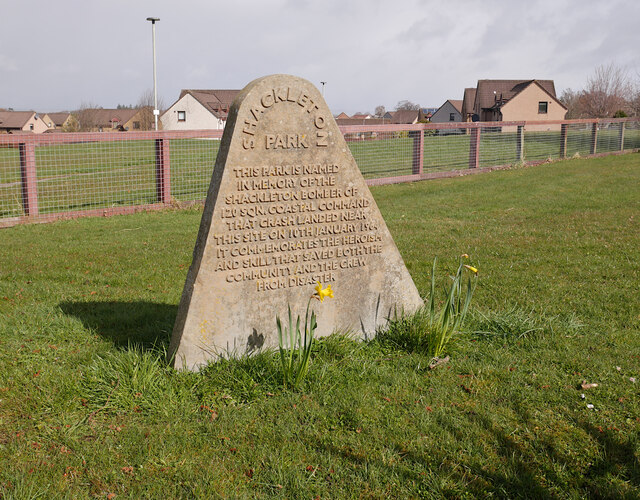
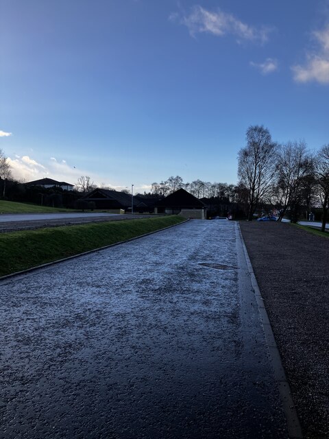
Easter Muckovie Images

Images are sourced within 2km of 57.4705/-4.1570005 or Grid Reference NH7044. Thanks to Geograph Open Source API. All images are credited.

A9 northbound
A9 northbound
Shackleton Park, Smithton A small grassy area amongst the housing estates. 

As it says on the stone:
This park is named in memory of the Shackleton Bomber of 120 Sqn Coastal Command that crash landed near this site on 10th January 1964. It commemorates the heroism and skill that saved both the community and crew from disaster.

An article from the Press & Journal. <span class="nowrap"><a title="https://www.pressandjournal.co.uk/fp/news/inverness/1097472/crash-site-history-restored/" rel="nofollow ugc noopener" href="https://www.pressandjournal.co.uk/fp/news/inverness/1097472/crash-site-history-restored/">Link</a><img style="margin-left:2px;" alt="External link" title="External link - shift click to open in new window" src="https://s1.geograph.org.uk/img/external.png" width="10" height="10"/></span>
Shackleton Park, Smithton
A small grassy area amongst the housing estates. As it says on the stone: This park is named in memory of the Shackleton Bomber of 120 Sqn Coastal Command that crash landed near this site on 10th January 1964. It commemorates the heroism and skill that saved both the community and crew from disaster. An article from the Press & Journal. LinkExternal link
Resaurie Bridge, Caulfield Road North The Highland Main Line railway crosses over this road. The road is blocked by bollards beneath the bridge, so it is passable by bicycle or motorcycle, but not cars.
Resaurie Bridge, Caulfield Road North
The Highland Main Line railway crosses over this road. The road is blocked by bollards beneath the bridge, so it is passable by bicycle or motorcycle, but not cars.
A9, northbound The A9 is a strategic link between the Highlands of Scotland and the Central Belt. It runs 279 miles from junction 5 of the M9 at Polmont to Scrabster. Originally it ran from Edinburgh.
<span class="nowrap"><a title="https://www.sabre-roads.org.uk/wiki/index.php?title=A9" rel="nofollow ugc noopener" href="https://www.sabre-roads.org.uk/wiki/index.php?title=A9">Link</a><img style="margin-left:2px;" alt="External link" title="External link - shift click to open in new window" src="https://s1.geograph.org.uk/img/external.png" width="10" height="10"/></span>
A9, northbound
The A9 is a strategic link between the Highlands of Scotland and the Central Belt. It runs 279 miles from junction 5 of the M9 at Polmont to Scrabster. Originally it ran from Edinburgh. LinkExternal link
New housing, by Barn Church Road Part of the expanding "Culloden West" development, off Barn Church Road. It includes several apartment blocks, as well as a range of houses.
New housing, by Barn Church Road
Part of the expanding "Culloden West" development, off Barn Church Road. It includes several apartment blocks, as well as a range of houses.
Track, by Ashton Farm A track from Ashton Farm towards the edge of the suburbs at Resaurie.
Track, by Ashton Farm
A track from Ashton Farm towards the edge of the suburbs at Resaurie.
Fields, by Ashton Farm Looking towards houses on the edge of the suburbs, around Resaurie and Smithton.
Fields, by Ashton Farm
Looking towards houses on the edge of the suburbs, around Resaurie and Smithton.
St Mary’s Well, Culloden Wood
B9006, Culloden Road
Nearing Inverness on the A9
B9006 near Westhill
B9006 near Westhill
Road to Blackpark Farm
Smithton Road bend
Smithton Road bend
Smithton Free Church Car Park
Building in Smithton
Junction with B9006
Junction with B9006
Inverness: the A9 approaches The A9 descends this hill and as it sweeps round to the right the Moray Firth comes into view - it's a long 108-mile slog from Perth and this means we've nearly made it!
Inverness: the A9 approaches
The A9 descends this hill and as it sweeps round to the right the Moray Firth comes into view - it's a long 108-mile slog from Perth and this means we've nearly made it!
Farm road to Easter Bogbain
Show me another place!

Easter Muckovie is located at Grid Ref: NH7044 (Lat: 57.4705, Lng: -4.1570005)

Unitary Authority: Highland

Police Authority: Highlands and Islands

What 3 Words

///sunset.label.songbook. Near Westhill, Highland

Nearby Locations

Easter Muckovie Inshes

Related Wikis

Westhill, Highland

Westhill (Gaelic: Cnoc Shuas) is a commuter village on the eastern outskirts of the city of Inverness, in the Highland council area of Scotland. It is...

Cradlehall

Cradlehall was originally the name given to the hall built by Major William Caulfield, later known as Cradlehall Farmhouse.Today it is a residential area...

Resaurie

Resaurie is a village, that lies between Culloden and Westhill in Inverness-shire, Scottish Highlands and is in the Scottish council area of Highland...

Smithton, Highland

Smithton (Gaelic: Baile a' Ghobhainn) is a residential area on the eastern outskirts of the city of Inverness, in the Highland council area of Scotland...

Nearby Amenities

Located within 500m of 57.4705,-4.1570005
Recycling
Source: survey
Lat/Long: 57.4721013/-4.1637233
Bus Stop
Source: survey
Lat/Long: 57.4744786/-4.1584303
Post Box
Collection Times: Mo-Fr 17:30; Sa 12:30
Operator: Royal Mail
Post Box Type: lamp
Ref: IV2 57
Royal Cypher: scottish_crown
Source: survey
Lat/Long: 57.4745169/-4.1581016
The Co-operative Food
Operator: The Co-operative Group
Shop: supermarket
Lat/Long: 57.4721056/-4.1642463
Traffic Signals
Lat/Long: 57.4730367/-4.1623366
Turning Circle
Lat/Long: 57.4701805/-4.1605266
Turning Circle
Lat/Long: 57.4701551/-4.1623309
Bus Stop
Caulfield Road
Naptan AtcoCode: 6700600003
Naptan Bearing: W
Naptan CommonName: Caulfield Road
Naptan Indicator: Bus Shelter
Naptan Landmark: Caulfield Ave
Naptan NaptanCode: 45323573
Naptan PlusbusZoneRef: IVRNESS
Naptan Street: Caulfield Road
Naptan Verified: no
Source: naptan_import
Lat/Long: 57.4744625/-4.1583612
Bus Stop
Caulfield Road
Naptan AtcoCode: 6700600005
Naptan Bearing: SW
Naptan CommonName: Caulfield Road
Naptan Indicator: at Cradlehall Park
Naptan Landmark: Cradlehall Park
Naptan NaptanCode: 45323268
Naptan PlusbusZoneRef: IVRNESS
Naptan Street: Caulfield Road
Naptan Verified: no
Source: naptan_import
Lat/Long: 57.4719093/-4.163681
Bus Stop
Caulfield Road
Naptan AtcoCode: 6700600008
Naptan Bearing: E
Naptan CommonName: Caulfield Road
Naptan Indicator: at Cradlehall Gardens
Naptan Landmark: Cradlehall Gardens
Naptan NaptanCode: 45324969
Naptan PlusbusZoneRef: IVRNESS
Naptan Street: Caulfield Road
Naptan Verified: no
Source: naptan_import
Lat/Long: 57.4743334/-4.1596045
Bus Stop
Cradlehall
Naptan AtcoCode: 6700600115
Naptan Bearing: W
Naptan CommonName: Cradlehall
Naptan Indicator: opp Cradlehall Park
Naptan Landmark: Cradlehall Park
Naptan NaptanCode: 45325726
Naptan PlusbusZoneRef: IVRNESS
Naptan Street: Culloden Road
Naptan Verified: no
Source: naptan_import
Lat/Long: 57.4697606/-4.1606021
Bus Stop
Cradlehall
Naptan AtcoCode: 6700600116
Naptan Bearing: E
Naptan CommonName: Cradlehall
Naptan Indicator: at Cradlehall Park
Naptan Landmark: Cradlehall Park
Naptan NaptanCode: 45325727
Naptan PlusbusZoneRef: IVRNESS
Naptan Street: Culloden Road
Naptan Verified: no
Source: naptan_import
Lat/Long: 57.4697199/-4.1613648
Bus Stop
Tower Road
Naptan AtcoCode: 6700711967
Naptan Bearing: W
Naptan CommonName: Tower Road
Naptan Indicator: opp Caulfiled Road
Naptan Landmark: Bus Shelter
Naptan NaptanCode: 45327579
Naptan Street: Tower Road
Naptan Verified: no
Source: naptan_import
Lat/Long: 57.4727665/-4.1501044
Bus Stop
Tower Road
Naptan AtcoCode: 6700711967A
Naptan Bearing: E
Naptan CommonName: Tower Road
Naptan Indicator: at path to Towerhill Road
Naptan Landmark: Bus Shelter
Naptan NaptanCode: 45329353
Naptan Street: Tower Road
Naptan Verified: no
Source: naptan_import
Lat/Long: 57.4728123/-4.1503068
Bus Stop
Caulfield Road
Naptan AtcoCode: 6700713252
Naptan Bearing: NE
Naptan CommonName: Caulfield Road
Naptan Indicator: opp Cradlehall Park
Naptan Landmark: Shopping Centre
Naptan NaptanCode: 45323574
Naptan PlusbusZoneRef: IVRNESS
Naptan Street: Caulfield Road
Naptan Verified: no
Source: naptan_import
Lat/Long: 57.4723534/-4.1634571
Cradlehall
Is In: Inverness
Place: suburb
Wikidata: Q5180497
Wikipedia: en:Cradlehall
Lat/Long: 57.4732799/-4.1624912
Turning Circle
Lat/Long: 57.4709424/-4.1651305
Post Box
Ref: IV2 102
Source: survey
Lat/Long: 57.4691865/-4.1622625
Noexit: yes
Lat/Long: 57.4700992/-4.1622287
Noexit: yes
Lat/Long: 57.4701501/-4.1606667
Noexit: yes
Lat/Long: 57.4702122/-4.1624541
Noexit: yes
Lat/Long: 57.4702141/-4.1603919
Power: substation
Substation: minor_distribution
Lat/Long: 57.4743483/-4.1526742
Operator: Scottish and Southern Energy
Power: substation
Substation: minor_distribution
Voltage Primary: 11000
Voltage Secondary: 415
Lat/Long: 57.4722044/-4.1631311
Generator Method: photovoltaic
Generator Output Electricity: yes
Generator Source: solar
Generator Type: solar_photovoltaic_panel
Location: roof
Power: generator
Lat/Long: 57.4706469/-4.1518297
Generator Method: photovoltaic
Generator Output Electricity: yes
Generator Source: solar
Generator Type: solar_photovoltaic_panel
Location: roof
Power: generator
Lat/Long: 57.4699574/-4.1517519
Generator Method: photovoltaic
Generator Output Electricity: yes
Generator Source: solar
Generator Type: solar_photovoltaic_panel
Location: roof
Power: generator
Lat/Long: 57.4693891/-4.1519504
Generator Method: photovoltaic
Generator Output Electricity: yes
Generator Source: solar
Generator Type: solar_photovoltaic_panel
Location: roof
Power: generator
Lat/Long: 57.4700916/-4.1533559
Generator Method: photovoltaic
Generator Output Electricity: yes
Generator Source: solar
Generator Type: solar_photovoltaic_panel
Location: roof
Power: generator
Lat/Long: 57.4728117/-4.1514998
Generator Method: photovoltaic
Generator Output Electricity: yes
Generator Source: solar
Generator Type: solar_photovoltaic_panel
Location: roof
Power: generator
Lat/Long: 57.4744659/-4.1564297
Generator Method: photovoltaic
Generator Output Electricity: yes
Generator Source: solar
Generator Type: solar_photovoltaic_panel
Location: roof
Power: generator
Lat/Long: 57.472206/-4.1598173
Generator Method: photovoltaic
Generator Output Electricity: yes
Generator Source: solar
Generator Type: solar_photovoltaic_panel
Location: roof
Power: generator
Lat/Long: 57.4713651/-4.1596591
Generator Method: photovoltaic
Generator Output Electricity: yes
Generator Source: solar
Generator Type: solar_photovoltaic_panel
Location: roof
Power: generator
Lat/Long: 57.4715339/-4.1591227
Post Box
Collection Times: Mo-Fr 17:30; Sa 12:30
Operator: Royal Mail
Post Box Manufacturer: Carron Company, Stirlingshire
Post Box Type: pillar
Ref: IV2 350
Royal Cypher: scottish_crown
Lat/Long: 57.472239/-4.1642388
Operator: Scottish and Southern Energy
Power: substation
Substation: minor_distribution
Voltage Primary: 11000
Voltage Secondary: 415
Lat/Long: 57.4679921/-4.1635544
Man Made: regulating_station
Pipeline: substation
Substation: distribution
Utility: gas
Lat/Long: 57.470856/-4.1651745
The data included in this document is from www.openstreetmap.org. The data is made available under ODbL.

Have you been to Easter Muckovie?

Leave your review of Easter Muckovie below (or comments, questions and feedback).