East Scrafton

Settlement in Yorkshire Richmondshire

England

East Scrafton

Field gate for footpath to Caldbergh
Field gate for footpath to Caldbergh Credit: peter robinson

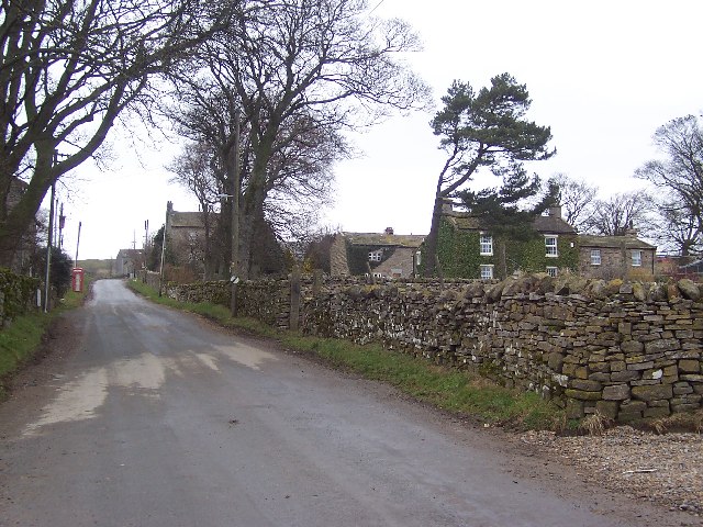
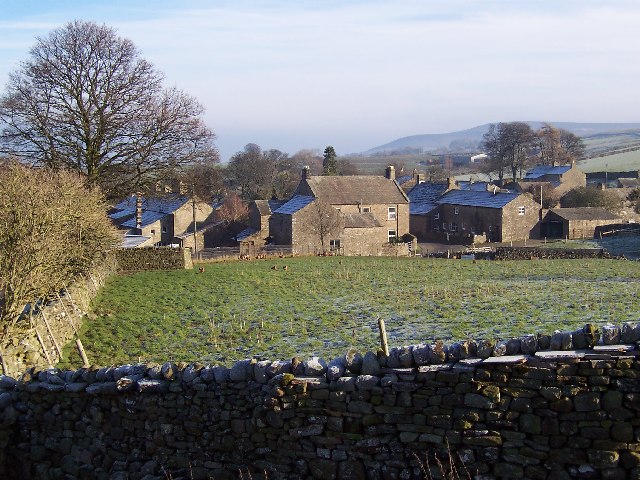
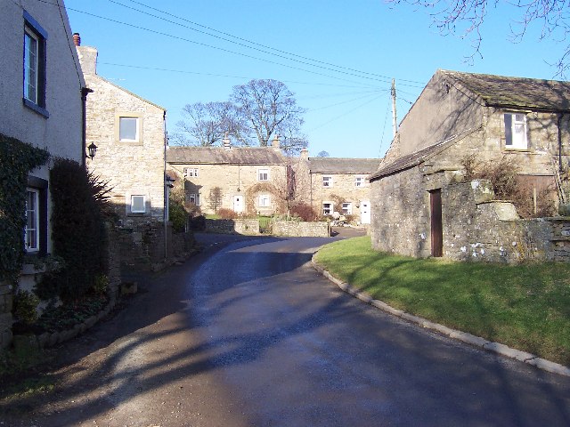
East Scrafton is a small village located in the county of Yorkshire, England. Situated in the Richmondshire district, it lies approximately 4 miles northeast of the town of Leyburn. With a population of around 200 residents, it is a close-knit community known for its picturesque surroundings and tranquil atmosphere.

The village is surrounded by rolling hills and lush green countryside, making it an ideal destination for nature lovers and hikers. The nearby River Ure adds to the charm of the area, offering opportunities for fishing and other water-based activities. The landscape is dotted with traditional stone houses and historic buildings, giving East Scrafton a timeless feel.

Despite its small size, the village boasts a strong sense of community. The local village hall serves as a social hub, hosting various events and activities throughout the year, including community gatherings, clubs, and exhibitions. The village also has a primary school, providing education for the local children.

East Scrafton is well-positioned for those seeking to explore the wider region. Just a short drive away is the market town of Leyburn, offering a range of amenities such as shops, restaurants, and pubs. The area is also renowned for its historic sites, including Bolton Castle and Middleham Castle, which attract visitors from near and far.

In summary, East Scrafton is a charming village in Yorkshire that encapsulates the beauty of rural England. Its idyllic location, strong community spirit, and proximity to larger towns and historical landmarks make it an appealing destination for both residents and visitors alike.

If you have any feedback on the listing, please let us know in the comments section below.

East Scrafton Images

Images are sourced within 2km of 54.257789/-1.8654979 or Grid Reference SE0884. Thanks to Geograph Open Source API. All images are credited.

Field gate for footpath to Caldbergh
Footpath through pasture to Caldbergh in Coverham
Bird Ridding Lane in Coverdale
Green's Beck in Coverham
East Scrafton Moor The moors on the south side of Coverdale seen from Town Head Cottage above Melmerby
East Scrafton Moor
The moors on the south side of Coverdale seen from Town Head Cottage above Melmerby
Cottages at West Scrafton A view across the head of Caygill to cottages on the far side.
Cottages at West Scrafton
A view across the head of Caygill to cottages on the far side.
Telephone kiosk and green at West Scrafton A very small Coverdale village with a suitably small green, at one side of which is the telephone kiosk.
Telephone kiosk and green at West Scrafton
A very small Coverdale village with a suitably small green, at one side of which is the telephone kiosk.
The post box in West Scrafton A 'VR' postbox set into the wall of a barn in West Scrafton.
The post box in West Scrafton
A 'VR' postbox set into the wall of a barn in West Scrafton.
Methodist chapel, West Scrafton Stone built chapel dated 1866 in West Scrafton.
Methodist chapel, West Scrafton
Stone built chapel dated 1866 in West Scrafton.
West Scrafton The view over the village from the moor track. Penhill dominates the distant skyline.
West Scrafton
The view over the village from the moor track. Penhill dominates the distant skyline.
Great Gill A sizeable beck flows down the gill, passes through West Scrafton in a gorge and empties into the River Cover.
Great Gill
A sizeable beck flows down the gill, passes through West Scrafton in a gorge and empties into the River Cover.
West Scrafton Looking across Coverdale, with the village of Carlton beyond on the far side of the dale.
West Scrafton
Looking across Coverdale, with the village of Carlton beyond on the far side of the dale.
Looking up to Great Roova Crags Through pasture to the south of West Scrafton, in Coverdale.
Looking up to Great Roova Crags
Through pasture to the south of West Scrafton, in Coverdale.
Great Roova Crags From just south of West Scrafton, in Coverdale.
Great Roova Crags
From just south of West Scrafton, in Coverdale.
Heading for Great Roova Crags On a superb Saturday afternoon in October, walkers follow the path south from West Scrafton.
Heading for Great Roova Crags
On a superb Saturday afternoon in October, walkers follow the path south from West Scrafton.
Bridge Cottage, West Scrafton In the gloaming at the end of a stunning (and unexpectedly) beautiful October day.
Bridge Cottage, West Scrafton
In the gloaming at the end of a stunning (and unexpectedly) beautiful October day.
Tatty barn at West Scrafton It appears that the Pennine weather has been at work on this barn close to West Scrafton village.
Tatty barn at West Scrafton
It appears that the Pennine weather has been at work on this barn close to West Scrafton village.
Old hedgerow trees A line of mature trees across a field at West Scrafton. Close examination reveals that they all have horizontal branches low down, indicating that they were once laid as a hedge.
Old hedgerow trees
A line of mature trees across a field at West Scrafton. Close examination reveals that they all have horizontal branches low down, indicating that they were once laid as a hedge.
Show me another place!

East Scrafton is located at Grid Ref: SE0884 (Lat: 54.257789, Lng: -1.8654979)

Division: North Riding

Administrative County: North Yorkshire

District: Richmondshire

Police Authority: North Yorkshire

What 3 Words

///scanty.secret.unopposed. Near Leyburn, North Yorkshire

Nearby Locations

East Scrafton Scar Wood

Related Wikis

East Scrafton

East Scrafton is a hamlet in the Yorkshire Dales in the Richmondshire district of North Yorkshire, England. It is about 3 miles (5 km) south-west of Leyburn...

Caldbergh

Caldbergh (Caldeber in the Domesday Book) is a hamlet within the Yorkshire Dales, North Yorkshire, England. It lies about four miles south of Leyburn....

Caldbergh with East Scrafton

Caldbergh with East Scrafton is a civil parish in the Richmondshire district of North Yorkshire, England. The parish includes the settlements of Caldbergh...

Melmerby in Coverdale

Melmerby is a village and civil parish in North Yorkshire, England. It lies in Coverdale in the Yorkshire Dales about 3 miles (4.8 km) south-west of Leyburn...

Agglethorpe

Agglethorpe is a hamlet in the Richmondshire district of North Yorkshire, England, it lies in northern Coverdale, approximately 4 miles (6.4 km) south...

West Scrafton

West Scrafton is a village and civil parish in Coverdale in the Yorkshire Dales, England. It is located 4 miles (6.4 km) south west of Leyburn. It falls...

Coverham with Agglethorpe

Coverham with Agglethorpe is a civil parish in North Yorkshire, England. It includes the villages of Coverham and Agglethorpe. The population of the civil...

Carlton, Richmondshire

Carlton is a village in the civil parish of Carlton Town in the Richmondshire district of North Yorkshire, England. According to the 2011 Census it had...

Nearby Amenities

Located within 500m of 54.257789,-1.8654979
St Simon's Chapel
Historic: ruins
Ruins: chapel
Lat/Long: 54.2600309/-1.8699318
Power: pole
Lat/Long: 54.2561617/-1.8720858
Power: pole
Lat/Long: 54.2566001/-1.8710729
Power: pole
Lat/Long: 54.2571331/-1.8694396
Power: pole
Lat/Long: 54.2576128/-1.8679431
Power: pole
Lat/Long: 54.2583524/-1.8665607
Power: pole
Lat/Long: 54.2588494/-1.866052
Power: pole
Lat/Long: 54.2591319/-1.8642293
Power: pole
Lat/Long: 54.2596289/-1.8630408
Power: pole
Lat/Long: 54.2601073/-1.86185
Power: pole
Lat/Long: 54.2605123/-1.8608417
Power: pole
Lat/Long: 54.2607815/-1.8604996
Power: pole
Lat/Long: 54.2612319/-1.8617337
The data included in this document is from www.openstreetmap.org. The data is made available under ODbL.

Have you been to East Scrafton?

Leave your review of East Scrafton below (or comments, questions and feedback).