Delfour

Settlement in Inverness-shire

Scotland

Delfour

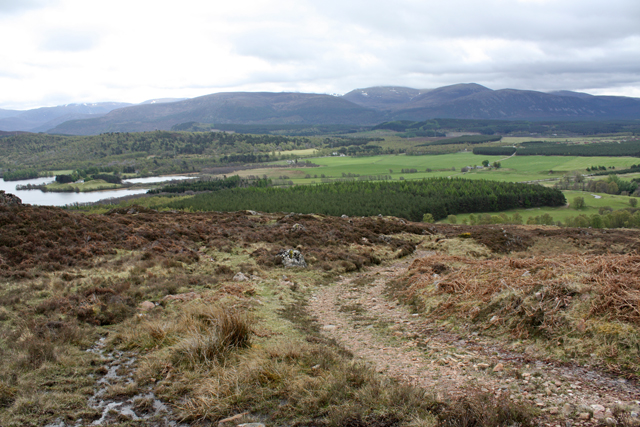
Hairpin bend on track to mast Two communications masts are sited on Creag a' Mhuilinn, this is the access track to them.
Hairpin bend on track to mast Credit: Dorothy Carse

The requested URL returned error: 429 Too Many Requests

If you have any feedback on the listing, please let us know in the comments section below.

Delfour Images

Images are sourced within 2km of 57.153348/-3.9129354 or Grid Reference NH8408. Thanks to Geograph Open Source API. All images are credited.

Hairpin bend on track to mast Two communications masts are sited on Creag a' Mhuilinn, this is the access track to them.
Hairpin bend on track to mast
Two communications masts are sited on Creag a' Mhuilinn, this is the access track to them.
Creag na h-Uamha Seen across the gully of Allt Chriochaidh.
Creag na h-Uamha
Seen across the gully of Allt Chriochaidh.
Track on Alvie Estate Access track for two communications masts on Creag a' Mhuilinn.  The Glenfeshie Hills are in the distance.
Track on Alvie Estate
Access track for two communications masts on Creag a' Mhuilinn. The Glenfeshie Hills are in the distance.
B9152 The B9152 runs 13 miles from Kingussie to Aviemore.
<span class="nowrap"><a title="https://www.sabre-roads.org.uk/wiki/index.php?title=B9152" rel="nofollow ugc noopener" href="https://www.sabre-roads.org.uk/wiki/index.php?title=B9152">Link</a><img style="margin-left:2px;" alt="External link" title="External link - shift click to open in new window" src="https://s1.geograph.org.uk/img/external.png" width="10" height="10"/></span>
B9152
The B9152 runs 13 miles from Kingussie to Aviemore. LinkExternal link
1H09 (170414) bound for Inverness near Wester Speybank
Access gate for track to Torr Alvie Track leads up to Duke of Gordon monument atop Torr Alvie passing the Waterloo Cairn on the way.
Access gate for track to Torr Alvie
Track leads up to Duke of Gordon monument atop Torr Alvie passing the Waterloo Cairn on the way.
B9152 bear Kincraig
B9152 bear Kincraig
Entrance to Alvie Quarry
Gravel track between the B9152 and the A9
Woodland near Alvie
Woodland near Alvie
B9152 near Alvie
B9152 near Alvie
B9152 near Dalraddy
B9152 near Dalraddy
Massed quad bikes at Dalraddy Holiday Park The bikes are parked close to the start of the path to Torr Alvie.
Massed quad bikes at Dalraddy Holiday Park
The bikes are parked close to the start of the path to Torr Alvie.
Autumnal trees close to path of Speyside Way The Speyside Way lies along the edge of the field from which the image was made.
The hill seen through mist is An Squabach which rises to Geal-Charn Mòr.
Autumnal trees close to path of Speyside Way
The Speyside Way lies along the edge of the field from which the image was made. The hill seen through mist is An Squabach which rises to Geal-Charn Mòr.
Northbound A9 near Dalraddy The A9 is a strategic link between the Highlands of Scotland and the Central Belt. Running for 273 miles, it is the longest road in Scotland and the fifth-longest A-road in the United Kingdom. Historically it was the main road between Edinburgh and John o' Groats but its importance has been eclipsed somewhat in the south by the A90 across the Forth Road Bridge and the M90 motorway, which now links Edinburgh more directly with Perth, and the M9, which is now the main road between Edinburgh and Bridge of Allan.
Northbound A9 near Dalraddy
The A9 is a strategic link between the Highlands of Scotland and the Central Belt. Running for 273 miles, it is the longest road in Scotland and the fifth-longest A-road in the United Kingdom. Historically it was the main road between Edinburgh and John o' Groats but its importance has been eclipsed somewhat in the south by the A90 across the Forth Road Bridge and the M90 motorway, which now links Edinburgh more directly with Perth, and the M9, which is now the main road between Edinburgh and Bridge of Allan.
A9 at Dalraddy The A9 is a strategic link between the Highlands of Scotland and the Central Belt. Running for 273 miles, it is the longest road in Scotland and the fifth-longest A-road in the United Kingdom. Historically it was the main road between Edinburgh and John o' Groats but its importance has been eclipsed somewhat in the south by the A90 across the Forth Road Bridge and the M90 motorway, which now links Edinburgh more directly with Perth, and the M9, which is now the main road between Edinburgh and Bridge of Allan.
A9 at Dalraddy
The A9 is a strategic link between the Highlands of Scotland and the Central Belt. Running for 273 miles, it is the longest road in Scotland and the fifth-longest A-road in the United Kingdom. Historically it was the main road between Edinburgh and John o' Groats but its importance has been eclipsed somewhat in the south by the A90 across the Forth Road Bridge and the M90 motorway, which now links Edinburgh more directly with Perth, and the M9, which is now the main road between Edinburgh and Bridge of Allan.
Show me another place!

Delfour is located at Grid Ref: NH8408 (Lat: 57.153348, Lng: -3.9129354)

Unitary Authority: Highland

Police Authority: Highlands and Islands

What 3 Words

///diverts.servicing.haven. Near Aviemore, Highland

Nearby Locations

Delfour

Related Wikis

Alvie

Alvie (Scottish Gaelic: Albhaidh) is a small crofting hamlet, a working Scottish highland estate and civil parish, located on the south shore of Loch Alvie...

River Feshie

The River Feshie (Scottish Gaelic: Fèisidh / Abhainn Fhèisidh) is a major right bank tributary of the River Spey in north-east Scotland. It rises in the...

Loch Alvie

Loch Alvie is a loch located north of the River Spey, in the civil parish of Alvie, in the council area of Highland, Scotland. The loch is about two miles...

Dalnavert, Highland

Dalnavert (Scottish Gaelic Dail nam Feart) is a small rural hamlet, that lies 4 miles northeast of Insh, and 8 miles northeast of Kingussie, in the...

Nearby Amenities

Located within 500m of 57.153348,-3.9129354
Archaeological Site: megalith
Historic: archaeological_site
Megalith Type: menhir
Lat/Long: 57.1534111/-3.9121802
Power: pole
Lat/Long: 57.1501577/-3.9179741
Power: pole
Lat/Long: 57.1508347/-3.9176836
Power: pole
Lat/Long: 57.1516212/-3.9173513
Power: pole
Lat/Long: 57.1519994/-3.9167378
Power: pole
Lat/Long: 57.1519363/-3.915878
Power: pole
Lat/Long: 57.1525855/-3.9153156
Power: pole
Lat/Long: 57.153285/-3.9147486
Power: pole
Lat/Long: 57.1539026/-3.913747
Power: pole
Lat/Long: 57.154253/-3.9128012
Power: pole
Lat/Long: 57.1544194/-3.9123341
Power: pole
Lat/Long: 57.1548694/-3.9110909
Power: pole
Lat/Long: 57.1552525/-3.9100359
Power: pole
Lat/Long: 57.1555916/-3.9090831
Power: pole
Lat/Long: 57.156015/-3.9079328
Power: pole
Lat/Long: 57.1563604/-3.9069242
Power: pole
Lat/Long: 57.1550332/-3.9123341
The data included in this document is from www.openstreetmap.org. The data is made available under ODbL.

Have you been to Delfour?

Leave your review of Delfour below (or comments, questions and feedback).