Beeby

Settlement in Leicestershire Charnwood

England

Beeby

Keyham Lane - early morning
Keyham Lane - early morning Credit: Dave Thompson

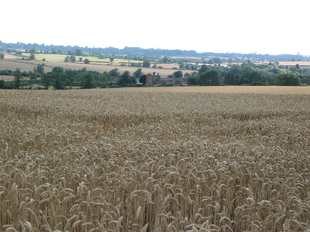
Beeby is a small village located in the county of Leicestershire, in the East Midlands region of England. Situated approximately 7 miles east of the city of Leicester, Beeby is nestled in the picturesque countryside, surrounded by rolling hills and lush greenery.

The village itself is home to a close-knit community, with a population of around 200 residents. Its quaint charm and peaceful atmosphere make Beeby an ideal place for those seeking a tranquil rural lifestyle. The architecture in Beeby is predominantly traditional, with a mix of stone cottages and more modern houses, blending seamlessly into the rural landscape.

Beeby is known for its strong sense of community spirit, with residents actively involved in various local activities and events. The village has a primary school, providing education for children within the local area. Additionally, there is a village hall that serves as a hub for social gatherings and community events.

For those who enjoy outdoor pursuits, Beeby offers plenty of opportunities to explore the surrounding countryside. The village is located near the Leicestershire Round, a long-distance footpath that takes hikers on a scenic journey through the county's landscapes. Furthermore, the nearby Bradgate Park, a historic deer park, offers stunning views and a chance to spot wildlife.

Although Beeby may be small in size, its warm community, idyllic countryside setting, and access to outdoor activities make it a charming place to live or visit for those seeking a peaceful retreat.

If you have any feedback on the listing, please let us know in the comments section below.

Beeby Images

Images are sourced within 2km of 52.667509/-1.020722 or Grid Reference SK6608. Thanks to Geograph Open Source API. All images are credited.

Keyham Lane - early morning
Beeby, All Saints
Beeby, All Saints
Beeby, Leicestershire A few  miles beyond the north-eastern outskirts of Leicester lies the tiny village of Beeby with a few houses, the Rectory and All Saints Church. The cottage garden in the foreground is a fascinating collection of plants in every conceivable container!
Beeby, Leicestershire
A few miles beyond the north-eastern outskirts of Leicester lies the tiny village of Beeby with a few houses, the Rectory and All Saints Church. The cottage garden in the foreground is a fascinating collection of plants in every conceivable container!
Spring Grange Fisheries, Beeby, Leicestershire Two small lakes for coarse fishing. I was assured by one of the fishermen that fish are plentiful and he regularly had catches of 8 to 10 lbs.
Spring Grange Fisheries, Beeby, Leicestershire
Two small lakes for coarse fishing. I was assured by one of the fishermen that fish are plentiful and he regularly had catches of 8 to 10 lbs.
Entrance to Spring Grange Fisheries The Fishery is on Croxton Road just outside Beeby on the way to South Croxton, (pronounced Crowson).
Entrance to Spring Grange Fisheries
The Fishery is on Croxton Road just outside Beeby on the way to South Croxton, (pronounced Crowson).
Barkby Holt, near South Croxton, Leicestershire From the top of the hill on Croxton Road there is a good view of Barkby Holt. This woodland fills the NW quarter of the square. The parish boundary runs from the road along the edge of the field and the Holt.
Barkby Holt, near South Croxton, Leicestershire
From the top of the hill on Croxton Road there is a good view of Barkby Holt. This woodland fills the NW quarter of the square. The parish boundary runs from the road along the edge of the field and the Holt.
Wheat field, between Beeby and South Croxton, Leicestershire Apart from Barkby Holt the farmland in this square is arable. This photograph was taken at SK 678 091. The buildings in the centre are Beeby Grange in the adjacent square.
Wheat field, between Beeby and South Croxton, Leicestershire
Apart from Barkby Holt the farmland in this square is arable. This photograph was taken at SK 678 091. The buildings in the centre are Beeby Grange in the adjacent square.
Farmland near Scraptoft Looking south east towards Scraptoft Lane
Farmland near Scraptoft
Looking south east towards Scraptoft Lane
Natural Burial Site, Scraptoft See <span class="nowrap"><a title="http://www.naturalburial.co.uk/natural.htm" rel="nofollow ugc noopener" href="http://www.naturalburial.co.uk/natural.htm">Link</a><img style="margin-left:2px;" alt="External link" title="External link - shift click to open in new window" src="https://s1.geograph.org.uk/img/external.png" width="10" height="10"/></span> for more information on this site and green burials in general
Natural Burial Site, Scraptoft
See LinkExternal link for more information on this site and green burials in general
Keyham Lane East, Scraptoft near Leicester The entrance to the <a href="https://www.geograph.org.uk/photo/104215">SK6606 : Natural Burial Site, Scraptoft</a> is on the left. Scraptoft Lodge Farm, on the horizon, is one of three farms in the adjacent square.
Keyham Lane East, Scraptoft near Leicester
The entrance to the SK6606 : Natural Burial Site, Scraptoft is on the left. Scraptoft Lodge Farm, on the horizon, is one of three farms in the adjacent square.
Nether Hall, Keyham near Leicester The tiny village of Keyham straddles the square boundary between SK6606 and SK6706. Nether Hall, on Snows Lane/Main Street junction, is in the featured square.
Nether Hall, Keyham near Leicester
The tiny village of Keyham straddles the square boundary between SK6606 and SK6706. Nether Hall, on Snows Lane/Main Street junction, is in the featured square.
Road Junction near Keyham Keyham Lane East to the left leads to Scaptoft. Keyham Lane to the right goes to the Beeby road.
Road Junction near Keyham
Keyham Lane East to the left leads to Scaptoft. Keyham Lane to the right goes to the Beeby road.
Farmland and Little Beeby, Leicestershire Another tiny Leicestershire village, Little Beeby is on Hungarton Lane. This photograph was taken from Keyham Lane.
Farmland and Little Beeby, Leicestershire
Another tiny Leicestershire village, Little Beeby is on Hungarton Lane. This photograph was taken from Keyham Lane.
Farmland near Keyham, Leicestershire Manor Farm is on the western edge of the square.
Farmland near Keyham, Leicestershire
Manor Farm is on the western edge of the square.
Barkby Grange, Leicester This Farmhouse is Grade II listed and was built in 1855. In a flamboyant picturesque gothic style, each facade is different. A range of farm buildings is listed also. More detailed description here <span class="nowrap"><a title="http://www.charnwood.gov.uk/environment/barkby.html" rel="nofollow ugc noopener" href="http://www.charnwood.gov.uk/environment/barkby.html">Link</a><img style="margin-left:2px;" alt="External link" title="External link - shift click to open in new window" src="https://s1.geograph.org.uk/img/external.png" width="10" height="10"/></span>
Barkby Grange, Leicester
This Farmhouse is Grade II listed and was built in 1855. In a flamboyant picturesque gothic style, each facade is different. A range of farm buildings is listed also. More detailed description here LinkExternal link
Farmland near Barkby Grange, Leicestershire Looking north east from Beeby Lane which clips the bottom left  hand corner of the square. The course of Barkby Brook can be seen in the foreground
Farmland near Barkby Grange, Leicestershire
Looking north east from Beeby Lane which clips the bottom left hand corner of the square. The course of Barkby Brook can be seen in the foreground
Farmland near Beeby House, Leicestershire This farm road leads to Beeby House which is in the next square north. There is a large group of fairly recent brick and metal barns on the right. Photograph taken from the bridge over Barkby Brook.
Farmland near Beeby House, Leicestershire
This farm road leads to Beeby House which is in the next square north. There is a large group of fairly recent brick and metal barns on the right. Photograph taken from the bridge over Barkby Brook.
Barkby Brook near Beeby, Leicestershire This small brook is an important part of the natural land drainage in this shallow valley. After heavy rain it can get very swollen. It is quite overgrown with hedge row trees along this stretch.
Barkby Brook near Beeby, Leicestershire
This small brook is an important part of the natural land drainage in this shallow valley. After heavy rain it can get very swollen. It is quite overgrown with hedge row trees along this stretch.
Show me another place!

Beeby is located at Grid Ref: SK6608 (Lat: 52.667509, Lng: -1.020722)

Administrative County: Leicestershire

District: Charnwood

Police Authority: Leicestershire

What 3 Words

///meanwhile.encourage.cackling. Near Syston, Leicestershire

Nearby Locations

Beeby Beeby

Related Wikis

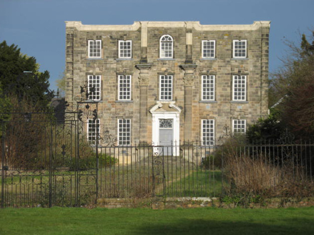
All Saints Church, Beeby

All Saints Church is a redundant Anglican church in the village of Beeby, Leicestershire, England. It is recorded in the National Heritage List for England...

Beeby

Beeby is a village and civil parish in the Charnwood district of Leicestershire, England, with a population of 115 according to the 2011 census. It is...

Keyham, Leicestershire

Keyham is an English village in Leicestershire. It lies about 7 miles (11 km) east of Leicester, in the district of Harborough. The population at the 2001...

Scraptoft Nature Reserve

Scraptoft Nature Reserve is a 14.3 hectares (35 acres) Local Nature Reserve in Scraptoft, on the eastern outskirts of Leicester. It is owned and managed...

Orchard Mead Academy

Orchard Mead Academy, previously known as Hamilton Community College, is a co-educational secondary school located in Leicester, England, taking children...

Scraptoft

Scraptoft is a village in Leicestershire, England. It has a population of about 1,500, measured at the 2011 census as 1,804. It lies north of the A47...

Barkby Thorpe

Barkby Thorpe is a hamlet and civil parish in the Charnwood district of Leicestershire, England. The hamlet has a population of around 50, and is close...

Scraptoft Hall

Scraptoft Hall is a former Georgian country house in the village of Scraptoft, Leicestershire, England. A Grade II* listed building, it has since been...

Nearby Amenities

Located within 500m of 52.667509,-1.020722
Beeby
Is In County: Leicestershire
Is In District: Charnwood
Place: village
Wikidata: Q4879553
Wikipedia: en:Beeby
Lat/Long: 52.6686038/-1.0212345
Bus Stop
Main Street
Alt Name: Beeby - All Saints Church
Bus: yes
Naptan AltCommonName: Beeby - All Saints Church
Naptan AtcoCode: 260006400
Naptan Bearing: S
Naptan CommonName: Main Street
Naptan Indicator: outside
Naptan Landmark: All Saints Church
Naptan NaptanCode: leidtpwj
Naptan Notes: Hourly - County
Naptan Street: Main Street
Naptan Verified: no
Public Transport: platform
Source: naptan_import
Lat/Long: 52.6684149/-1.0197656
Bus Stop
Main Street
Bus: yes
Naptan AtcoCode: 260006401
Naptan Bearing: N
Naptan BusStopType: CUS
Naptan CommonName: Main Street
Naptan Indicator: opposite
Naptan Landmark: All Saints Church
Naptan NaptanCode: leidtpwm
Naptan Notes: Hourly - County
Naptan Street: Main Street
Naptan Verified: no
Public Transport: platform
Source: naptan_import
Lat/Long: 52.6683537/-1.019974
Lane End Farm
Place: farm
Source: Bing
Lat/Long: 52.6705313/-1.020388
The Cottage
Place: isolated_dwelling
Source: Bing
Lat/Long: 52.66537/-1.0178969
The data included in this document is from www.openstreetmap.org. The data is made available under ODbL.

Have you been to Beeby?

Leave your review of Beeby below (or comments, questions and feedback).