Malkin's Bank

Settlement in Cheshire

England

Malkin's Bank

Hassall Green Post Office and General Store right by the canal, but unfortunately right by the M6 too
Hassall Green Post Office and General Store Credit: Andrew Longton

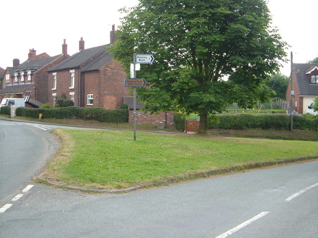
Malkin's Bank is a small village located in the county of Cheshire, England. Situated near the town of Sandbach, Malkin's Bank is steeped in history and offers a charming and tranquil atmosphere to its residents and visitors.

The village takes its name from the nearby Malkin's Bank Farm, a historic farmhouse dating back to the 17th century. The area is known for its picturesque countryside, with rolling hills, lush greenery, and scenic views that attract nature enthusiasts and hikers.

Despite its small size, Malkin's Bank boasts a strong sense of community and offers a range of amenities for its inhabitants. The village features a local pub, The Malkin's Bank Inn, which serves as a popular gathering spot for locals and visitors alike. The pub offers a warm and inviting atmosphere, with traditional British fare and a selection of beverages.

In addition to its natural beauty and community spirit, Malkin's Bank benefits from its convenient location. The nearby town of Sandbach provides access to various shops, supermarkets, and services, ensuring that residents have easy access to daily necessities.

Overall, Malkin's Bank is a peaceful and idyllic village in Cheshire, offering a perfect blend of rural charm and modern convenience. Whether it's exploring the beautiful countryside, enjoying the local pub, or simply embracing the tranquility of village life, Malkin's Bank provides a delightful escape from the hustle and bustle of city living.

If you have any feedback on the listing, please let us know in the comments section below.

Malkin's Bank Images

Images are sourced within 2km of 53.129861/-2.357167 or Grid Reference SJ7659. Thanks to Geograph Open Source API. All images are credited.

Hassall Green Post Office and General Store right by the canal, but unfortunately right by the M6 too
Hassall Green Post Office and General Store
right by the canal, but unfortunately right by the M6 too
Big Hindheath Farm
Big Hindheath Farm
Randle Rode This splendid 17th century Tudor-style house on the A533 bears the legend Randle Rode 1684.
Rode Hall Estate lies a couple of miles to the south-east of here, but the family have been landowners in the area for centuries. If you look closely, the large vertical stone in the garden wall has a face carved into it, as have other smaller ones which picture compression has rendered invisible.
Randle Rode
This splendid 17th century Tudor-style house on the A533 bears the legend Randle Rode 1684. Rode Hall Estate lies a couple of miles to the south-east of here, but the family have been landowners in the area for centuries. If you look closely, the large vertical stone in the garden wall has a face carved into it, as have other smaller ones which picture compression has rendered invisible.
Boult's Green Farm A view of the farm buildings, looking back north-east up Vicarage Lane from Colley Lane, towards the A533 and Betchton Heath.
Boult's Green Farm
A view of the farm buildings, looking back north-east up Vicarage Lane from Colley Lane, towards the A533 and Betchton Heath.
Stannerhouse Lane Steps The point at which the country footpath from Stannerhouse Lane rises into the fields behind Boult's Green Farm, crossing the farmland by Tall Chimneys to emerge onto Colley Lane, below the farmhouse on Vicarage Lane at Boult's Green.
Stannerhouse Lane Steps
The point at which the country footpath from Stannerhouse Lane rises into the fields behind Boult's Green Farm, crossing the farmland by Tall Chimneys to emerge onto Colley Lane, below the farmhouse on Vicarage Lane at Boult's Green.
Woods & Stream Early stages of the River Wheelock
Woods & Stream
Early stages of the River Wheelock
Wheelock Hall Farm Old tractor outside farmyard open to the public
Wheelock Hall Farm
Old tractor outside farmyard open to the public
Hassall Green The junction at the north end of Hassall Green, seen from the northeast. Off to the right is Betchton Road; Smithy Grove and the rest of the village to the left.
Hassall Green
The junction at the north end of Hassall Green, seen from the northeast. Off to the right is Betchton Road; Smithy Grove and the rest of the village to the left.
St Philip's Church, Hassall Green <span class="nowrap"><a title="http://www.sandbachanglicans.ukf.net/stp.htm" rel="nofollow ugc noopener" href="http://www.sandbachanglicans.ukf.net/stp.htm">Link</a><img style="margin-left:2px;" alt="External link" title="External link - shift click to open in new window" src="https://s1.geograph.org.uk/img/external.png" width="10" height="10"/></span>
St Philip's Church, Hassall Green
Malkin's Bank Golf Course View from the footpath of the Trent and Mersey Canal across the golf course. Hassall House Farm can be seen in the distance.
Malkin's Bank Golf Course
View from the footpath of the Trent and Mersey Canal across the golf course. Hassall House Farm can be seen in the distance.
Transport through the ages A barge on the Trent and Mersey Canal passes under the M6 motorway bridge just to the west of Hassall Green Locks.
Transport through the ages
A barge on the Trent and Mersey Canal passes under the M6 motorway bridge just to the west of Hassall Green Locks.
Locks at Malkin's Bank Taken from the bridge over the Trent and Mersey Canal locks towards the backs of the original terraced houses on Betchton Road.
Locks at Malkin's Bank
Taken from the bridge over the Trent and Mersey Canal locks towards the backs of the original terraced houses on Betchton Road.
Wheelock Services British Waterways services on the Trent and Mersey canal at Wheelock
Wheelock Services
British Waterways services on the Trent and Mersey canal at Wheelock
Wheelock Rail Trail This disused railway line has been converted to a path. It runs through Wheelock from Ettiley Heath in the north to join the Trent and Mersey towpath near Malkin's Bank.
Wheelock Rail Trail
This disused railway line has been converted to a path. It runs through Wheelock from Ettiley Heath in the north to join the Trent and Mersey towpath near Malkin's Bank.
Canalside Farm
Canalside Farm
A534 Canal Bridge
A534 Canal Bridge
School Farm, Hassall
South Cheshire Way at School Farm At this point the South Cheshire Way follows the road for only 50m or so before heading off down the side of the farm buildings.
South Cheshire Way at School Farm
At this point the South Cheshire Way follows the road for only 50m or so before heading off down the side of the farm buildings.
Show me another place!

Malkin's Bank is located at Grid Ref: SJ7659 (Lat: 53.129861, Lng: -2.357167)

Unitary Authority: Cheshire East

Police Authority: Cheshire

What 3 Words

///intestine.lessening.suspended. Near Sandbach, Cheshire

Nearby Locations

Malkin's Bank

Related Wikis

Wheelock, Cheshire

Wheelock is a large village in the civil parish of Sandbach which is in the unitary authority of Cheshire East and the ceremonial county of Cheshire, England...

Wheelock & Sandbach railway station

Wheelock & Sandbach railway station was built by the North Staffordshire Railway (NSR) to serve the Cheshire village of Wheelock. Originally conceived...

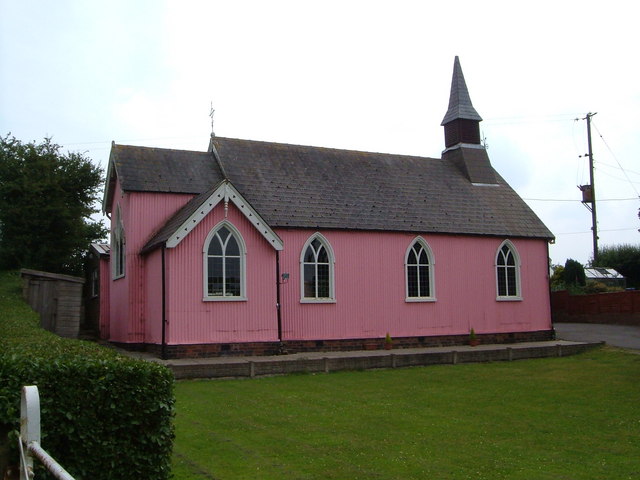
Christ Church, Wheelock

Christ Church is in Crewe Road, Wheelock, Cheshire, England. It is an active Anglican parish church in the deanery of Congleton, the archdeaconry of Macclesfield...

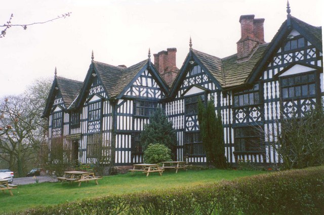
Old Hall Hotel, Sandbach

The Old Hall Hotel is a public house and restaurant in High Street, Sandbach, Cheshire, England. It was built in 1656 on the site of a previous manor...

Nearby Amenities

Located within 500m of 53.129861,-2.357167
Seamark Type: gate
Waterway: lock_gate
Lat/Long: 53.1292649/-2.3585938
Waterway: turning_point
Lat/Long: 53.1292279/-2.3572012
Seamark Type: gate
Waterway: lock_gate
Lat/Long: 53.1291836/-2.3558891
Seamark Type: gate
Waterway: lock_gate
Lat/Long: 53.1291397/-2.3555355
Seamark Type: gate
Waterway: lock_gate
Lat/Long: 53.12842/-2.3526474
Seamark Type: gate
Waterway: lock_gate
Lat/Long: 53.1279473/-2.3506347
Malkins Bank
Place: hamlet
Lat/Long: 53.1292288/-2.3537569
Seamark Type: gate
Waterway: lock_gate
Lat/Long: 53.1284883/-2.3529612
Bus Stop
Malkins Bank, Betchton Road / Crown Drive
Bus: yes
Naptan AtcoCode: 0600CO5037
Naptan Bearing: NW
Naptan CommonName: Crown Drive
Naptan Crossing: Crown Drive
Naptan Indicator: cnr
Naptan Landmark: Crown Drive
Naptan LocalityName: Malkins Bank
Naptan NaptanCode: chepjtj
Naptan ShortCommonName: Crown Drive
Naptan Street: Betchton Road
Naptan Verified: no
Network: Cheshire East Council
Operator: Ansa Transport
Public Transport: platform
Source: naptan_import
Lat/Long: 53.1287352/-2.3519475
Bus Stop
Malkins Bank, Betchton Road / Crown Drive
Bus: yes
Naptan AtcoCode: 0600CO5038
Naptan Bearing: SE
Naptan CommonName: Crown Drive
Naptan Crossing: Crown Drive
Naptan Indicator: opp
Naptan Landmark: Crown Drive
Naptan LocalityName: Malkins Bank
Naptan NaptanCode: chepjtm
Naptan ShortCommonName: Crown Drive
Naptan Street: Betchton Road
Naptan Verified: no
Network: Cheshire East Council
Operator: Ansa Transport
Public Transport: platform
Source: naptan_import
Lat/Long: 53.1288612/-2.3518887
Bus Stop
Malkins Bank, Betchton Road
Bus: yes
Naptan AtcoCode: 0600CO5039
Naptan Bearing: SE
Naptan CommonName: Betchton Road
Naptan Indicator: SE-bound
Naptan Landmark: House number 10
Naptan LocalityName: Malkins Bank
Naptan NaptanCode: chepjtp
Naptan ShortCommonName: Betchton Road
Naptan Street: Betchton Road
Naptan Verified: no
Network: Cheshire East Council
Operator: Ansa Transport
Public Transport: platform
Source: naptan_import
Lat/Long: 53.1294096/-2.3549272
Bus Stop
Malkins Bank, Betchton Road
Bus: yes
Naptan AtcoCode: 0600CO5040
Naptan Bearing: NW
Naptan BusStopType: CUS
Naptan CommonName: Betchton Road
Naptan Indicator: NW-bound
Naptan Landmark: House number 19
Naptan LocalityName: Malkins Bank
Naptan NaptanCode: chepjtw
Naptan ShortCommonName: Betchton Road
Naptan Street: Betchton Road
Naptan Verified: no
Network: Cheshire East Council
Operator: Ansa Transport
Public Transport: platform
Source: naptan_import
Lat/Long: 53.1296221/-2.35599
Seamark Type: gate
Waterway: lock_gate
Lat/Long: 53.1293382/-2.3585694
Seamark Type: gate
Waterway: lock_gate
Lat/Long: 53.1278856/-2.3506715
Seamark Type: gate
Waterway: lock_gate
Lat/Long: 53.1290695/-2.355558
Seamark Type: gate
Waterway: lock_gate
Lat/Long: 53.1292403/-2.3582409
Seamark Type: gate
Waterway: lock_gate
Lat/Long: 53.1293157/-2.3582297
Seamark Type: gate
Waterway: lock_gate
Lat/Long: 53.1279589/-2.3509929
Seamark Type: gate
Waterway: lock_gate
Lat/Long: 53.1280183/-2.3509634
Seamark Type: gate
Waterway: lock_gate
Lat/Long: 53.1291144/-2.3559155
Cafe
Malkins Bank Golf Course Cafe
Lat/Long: 53.127688/-2.3515266
Generator Method: photovoltaic
Generator Output Electricity: yes
Generator Source: solar
Generator Type: solar_photovoltaic_panel
Power: generator
Lat/Long: 53.1295261/-2.3547327
The data included in this document is from www.openstreetmap.org. The data is made available under ODbL.

Have you been to Malkin's Bank?

Leave your review of Malkin's Bank below (or comments, questions and feedback).