Central Lydbrook

Settlement in Gloucestershire Forest of Dean

England

Central Lydbrook

Mirystock Bridge
Mirystock Bridge Credit: don cload

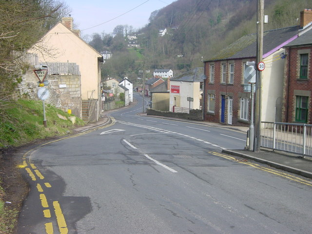
Central Lydbrook is a small village located in the Forest of Dean district of Gloucestershire, England. Situated on the banks of the River Wye, it is surrounded by stunning natural beauty and offers a tranquil and picturesque setting for residents and visitors alike.

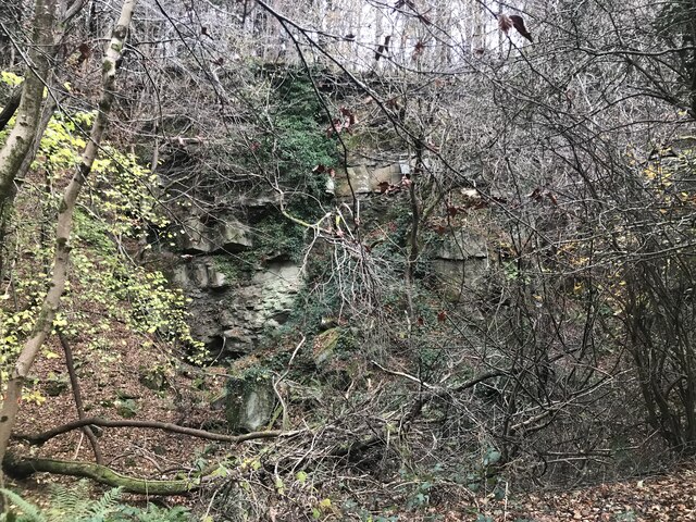
The village is known for its rich history, dating back to medieval times when it was primarily an agricultural community. Over the years, it has evolved into a residential area with a close-knit community. The architecture reflects its past, with charming cottages and buildings that exude traditional English charm.

Despite its small size, Central Lydbrook offers a range of amenities to cater to the needs of its residents. There is a primary school, a post office, a convenience store, and a local pub that serves as a popular gathering spot. The village also boasts several walking trails, allowing nature enthusiasts to explore the surrounding woodlands and enjoy the breathtaking scenery.

One notable feature of Central Lydbrook is the heritage railway line that runs through the village. The Dean Forest Railway, a preserved steam railway, attracts tourists and train enthusiasts from near and far. This historical railway contributes to the village's tourism industry and offers a unique experience for visitors.

Overall, Central Lydbrook is a charming and idyllic village that offers a peaceful and scenic retreat from the hustle and bustle of city life. Its rich history, natural beauty, and close-knit community make it a desirable place to visit or call home.

If you have any feedback on the listing, please let us know in the comments section below.

Central Lydbrook Images

Images are sourced within 2km of 51.839312/-2.5796811 or Grid Reference SO6015. Thanks to Geograph Open Source API. All images are credited.

Mirystock Bridge
Mirystock Bridge
Old chapel and recreation ground
Old railway
Old railway
Old quarry
Old quarry
Sharp turn in the forest track
Old Boundary Marker Estate Boundary Marker east of a forest track and just north of the A4136 near Mirystock House. Lydbrook parish. inscribed Bourts Inclosure and 1842 this perhaps records the enclosure of part of the Forest of Dean.

Milestone Society National ID: GL_LYDBR01em
Old Boundary Marker
Estate Boundary Marker east of a forest track and just north of the A4136 near Mirystock House. Lydbrook parish. inscribed Bourts Inclosure and 1842 this perhaps records the enclosure of part of the Forest of Dean. Milestone Society National ID: GL_LYDBR01em
Modern Boundary Stone, Ruardean High on the Northern embankment of "Townsend". One of the many replacement boundary stone delineating the periphery of the "Forest of Dean". The "Forest" is very specific because resident have "rights in common" like grazing sheep and coal mining, though you may have to be born there to classify as a "free miner". 

Inscription: D. F. / No 116 / 2010 

Milestone Society National ID: GL_DFRUAR116em
Modern Boundary Stone, Ruardean
High on the Northern embankment of "Townsend". One of the many replacement boundary stone delineating the periphery of the "Forest of Dean". The "Forest" is very specific because resident have "rights in common" like grazing sheep and coal mining, though you may have to be born there to classify as a "free miner". Inscription: D. F. / No 116 / 2010 Milestone Society National ID: GL_DFRUAR116em
Modern Boundary Stone, The Pludds On the North verge of Highbeech Road. One of the many replacement boundary stone delineating the periphery of the "Forest of Dean". The "Forest" is very specific because resident have "rights in common" like grazing sheep and coal mining, though you may have to be born there to classify as a "free miner".

Inscription: D. F. / 20005 / Nᴼ. 118

Milestone Society National ID: GL_DFRUAR118em
Modern Boundary Stone, The Pludds
On the North verge of Highbeech Road. One of the many replacement boundary stone delineating the periphery of the "Forest of Dean". The "Forest" is very specific because resident have "rights in common" like grazing sheep and coal mining, though you may have to be born there to classify as a "free miner". Inscription: D. F. / 20005 / Nᴼ. 118 Milestone Society National ID: GL_DFRUAR118em
Stone Stile, Ruardean Alongside Gloucestershire footpath DRD32, an obsolete stile to the adjacent field. Midway between Pettycroft and Eddys Lane.
Stone Stile, Ruardean
Alongside Gloucestershire footpath DRD32, an obsolete stile to the adjacent field. Midway between Pettycroft and Eddys Lane.
Stone Stile, Ruardean On Gloucestershire footpath DRD32 off Eddys Lane. The remnants of a "Fallen Idle".
Stone Stile, Ruardean
On Gloucestershire footpath DRD32 off Eddys Lane. The remnants of a "Fallen Idle".
The work of beavers The work of beavers by Greakthough Brook in the Forest of Dean.
The work of beavers
The work of beavers by Greakthough Brook in the Forest of Dean.
Sign of beaver activity Sign of beaver activity by Greathough Brook in the Forest of Dean.
Sign of beaver activity
Sign of beaver activity by Greathough Brook in the Forest of Dean.
Footbridge and stream Footbridge and stream on a former railway trackbed.
Footbridge and stream
Footbridge and stream on a former railway trackbed.
Memorial to the Waterloo Colliery Disaster Memorial to the Waterloo Colliery Disaster of 30 June 1949 <a href="https://www.geograph.org.uk/photo/7339405">SO6114 : Detail of the Waterloo Colliery Disaster Memorial</a>, on that day the pit was flooded when a breach was made into the water-filled workings of East Slad Colliery. Despite flooding, 177 men escaped by means of the cage up the shaft. There were a further 5 missing men who were eventually contacted and rescued via the old Pluds' Colliery shaft, fortunately this had recently been re-opened for ventilation purposes. The colliery finally closed on 23 December 1959.  Officially this was the Arthur and Edward Colliery. <a href="https://www.geograph.org.uk/photo/7339411">SO6114 : Inscription on Colliery Memorial</a>
Memorial to the Waterloo Colliery Disaster
Memorial to the Waterloo Colliery Disaster of 30 June 1949 SO6114 : Detail of the Waterloo Colliery Disaster Memorial, on that day the pit was flooded when a breach was made into the water-filled workings of East Slad Colliery. Despite flooding, 177 men escaped by means of the cage up the shaft. There were a further 5 missing men who were eventually contacted and rescued via the old Pluds' Colliery shaft, fortunately this had recently been re-opened for ventilation purposes. The colliery finally closed on 23 December 1959. Officially this was the Arthur and Edward Colliery. SO6114 : Inscription on Colliery Memorial
Detail of the Waterloo Colliery Disaster Memorial Memorial to the Waterloo Colliery Disaster of 30 June 1949 <a href="https://www.geograph.org.uk/photo/7339404">SO6114 : Memorial to the Waterloo Colliery Disaster</a>, on that day the pit was flooded when a breach was made into the water-filled workings of East Slad Colliery. Despite flooding, 177 men escaped by means of the cage up the shaft. There were a further 5 missing men who were eventually contacted and rescued via the old Pluds' Colliery shaft, fortunately this had recently been re-opened for ventilation purposes. The colliery finally closed on 23 December 1959.  Officially this was the Arthur and Edward Colliery. <a href="https://www.geograph.org.uk/photo/7339411">SO6114 : Inscription on Colliery Memorial</a>
Detail of the Waterloo Colliery Disaster Memorial
Memorial to the Waterloo Colliery Disaster of 30 June 1949 SO6114 : Memorial to the Waterloo Colliery Disaster, on that day the pit was flooded when a breach was made into the water-filled workings of East Slad Colliery. Despite flooding, 177 men escaped by means of the cage up the shaft. There were a further 5 missing men who were eventually contacted and rescued via the old Pluds' Colliery shaft, fortunately this had recently been re-opened for ventilation purposes. The colliery finally closed on 23 December 1959. Officially this was the Arthur and Edward Colliery. SO6114 : Inscription on Colliery Memorial
Inscription on Colliery Memorial Inscription on the memorial marking the Waterloo Colliery Disaster of 30 June 1949.
Inscription on Colliery Memorial
Inscription on the memorial marking the Waterloo Colliery Disaster of 30 June 1949.
The Wye valley viewed from Readings View of the sweeping loop in the River Wye below Kerne Bridge, viewed here from Readings.
The Wye valley viewed from Readings
View of the sweeping loop in the River Wye below Kerne Bridge, viewed here from Readings.
View to the Brecon Beacons View to the Brecon Beacons from Readings on the northern edge of the Forest of Dean.  There is a nice alignment here of Ysgyryd Fawr (Skirrid), Sugar Loaf and Corn Du and Pen y Fan in the Brecon Beacons.
View to the Brecon Beacons
View to the Brecon Beacons from Readings on the northern edge of the Forest of Dean. There is a nice alignment here of Ysgyryd Fawr (Skirrid), Sugar Loaf and Corn Du and Pen y Fan in the Brecon Beacons.
Show me another place!

Central Lydbrook is located at Grid Ref: SO6015 (Lat: 51.839312, Lng: -2.5796811)

Administrative County: Gloucestershire

District: Forest of Dean

Police Authority: Gloucestershire

What 3 Words

///iteration.catchers.puns. Near Lydbrook, Gloucestershire

Related Wikis

Lydbrook

Lydbrook is a civil parish in the Forest of Dean, a local government district in the English county of Gloucestershire and is located in the Wye Valley...

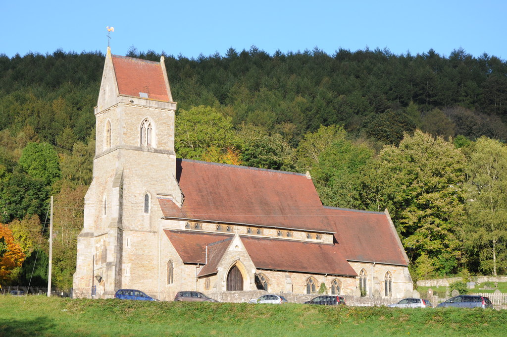
Holy Jesus Church, Lydbrook

Holy Jesus Church at Lydbrook is a Church of England parish church in the English county of Gloucestershire. == Structure == The greater part of the church...

Upper Lydbrook railway station

Upper Lydbrook railway station served the civil parish of Lydbrook, Gloucestershire, England, from 1875 to 1929 on the Severn and Wye Railway. == History... ==

Sarah Siddons' House

Sarah Siddons' House, also called the Old House, is a cottage in the village of Lydbrook, Gloucestershire, England. A Grade II* listed building, the cottage...

Nearby Amenities

Located within 500m of 51.839312,-2.5796811
Bus Stop
Jovial Colliers Inn
Naptan AtcoCode: 1600GL2657
Naptan Bearing: NW
Naptan CommonName: Jovial Colliers Inn
Naptan NaptanCode: gloagjma
Naptan Street: B4234
Naptan Verified: no
Source: naptan_import
Lat/Long: 51.8373387/-2.5774258
Bus Stop
Jovial Colliers Inn
Naptan AtcoCode: 1600GL2658
Naptan Bearing: SE
Naptan CommonName: Jovial Colliers Inn
Naptan Indicator: Opp
Naptan NaptanCode: gloagjmd
Naptan Street: B4234
Naptan Verified: no
Source: naptan_import
Lat/Long: 51.8374109/-2.5773686
Bus Stop
British Legion Club
Bus: yes
Naptan AtcoCode: 1600GL3113
Naptan Bearing: NW
Naptan CommonName: British Legion Club
Naptan Indicator: Opp
Naptan NaptanCode: gloagdtp
Naptan Street: B4234
Naptan Verified: no
Public Transport: platform
Source: naptan_import
Lat/Long: 51.841132/-2.5812918
Bus Stop
British Legion Club
Bus: yes
Naptan AtcoCode: 1600GL3114
Naptan Bearing: SE
Naptan CommonName: British Legion Club
Naptan NaptanCode: gloagdwa
Naptan Street: B4234
Naptan Verified: no
Public Transport: platform
Shelter: yes
Source: naptan_import
Lat/Long: 51.8410708/-2.5809282
Bus Stop
Anchor Inn
Bus: yes
Naptan AtcoCode: 1600GLF439
Naptan Bearing: NW
Naptan CommonName: Anchor Inn
Naptan Indicator: Opp
Naptan NaptanCode: gloagdmp
Naptan Street: B4234
Naptan Verified: no
Public Transport: platform
Source: naptan_import
Lat/Long: 51.8423459/-2.5848929
Bus Stop
Anchor Inn
Bus: yes
Naptan AtcoCode: 1600GLF440
Naptan Bearing: SE
Naptan CommonName: Anchor Inn
Naptan NaptanCode: gloagdmt
Naptan Street: B4234
Naptan Verified: no
Public Transport: platform
Source: naptan_import
Lat/Long: 51.8423912/-2.5848354
Bus Stop
Holy Jesus Church
Naptan AtcoCode: 1600GLF579
Naptan Bearing: W
Naptan CommonName: Holy Jesus Church
Naptan NaptanCode: glogjwdj
Naptan Street: Church Rd
Naptan Verified: no
Source: naptan_import
Lat/Long: 51.8388099/-2.5762834
Bus Stop
Holy Jesus Church
Naptan AtcoCode: 1600GLF580
Naptan Bearing: E
Naptan CommonName: Holy Jesus Church
Naptan Indicator: Opp
Naptan NaptanCode: gloagjpd
Naptan Street: Church Rd
Naptan Verified: no
Source: naptan_import
Lat/Long: 51.8388633/-2.5763857
Bus Stop
Church Hill Top
Naptan AtcoCode: 1600GLF595
Naptan Bearing: SE
Naptan CommonName: Church Hill Top
Naptan NaptanCode: gloagjtp
Naptan Street: Joy's Green Rd
Naptan Verified: no
Source: naptan_import
Lat/Long: 51.8391882/-2.5742997
Bus Stop
Church Hill Top
Naptan AtcoCode: 1600GLF596
Naptan Bearing: NW
Naptan CommonName: Church Hill Top
Naptan NaptanCode: gloagjtm
Naptan Street: Joy's Green Rd
Naptan Verified: no
Source: naptan_import
Lat/Long: 51.8392771/-2.5745041
Bus Stop
Jovial Colliers Inn
Naptan AtcoCode: 1600GLF819
Naptan Bearing: W
Naptan CommonName: Jovial Colliers Inn
Naptan Indicator: Opp
Naptan NaptanCode: gloagjpa
Naptan Street: Church Rd
Naptan Verified: no
Source: naptan_import
Lat/Long: 51.8368942/-2.5763896
Bus Stop
Jovial Colliers Inn
Naptan AtcoCode: 1600GLF820
Naptan Bearing: E
Naptan CommonName: Jovial Colliers Inn
Naptan Indicator: Opp
Naptan NaptanCode: gloagjmw
Naptan Street: Church Rd
Naptan Verified: no
Source: naptan_import
Lat/Long: 51.8369567/-2.5764775
Upper Lydbrook
Historic Railway: station
Railway: site
Wikidata: Q108882188
Wikipedia: en:Upper Lydbrook railway station
Lat/Long: 51.8386671/-2.5761151
Post Office
Lydbrook Post Office
Addr City: Lydbrook
Addr Country: GB
Addr Postcode: GL17 9SA
Addr Street: Bell Hill
Brand: Post Office
Brand Wikidata: Q1783168
Opening Hours: Mo-Sa 07:00-19:00; Su 09:00-13:00
Operator: Central
Ref Pol Id: 118747
Website: https://www.postoffice.co.uk/branch-finder/2504588/lydbrook
Lat/Long: 51.840689/-2.5810441
Upper Lydbrook
Place: village
Source: NLS - OS 1:25k 1st Series 1937-61
Lat/Long: 51.8367532/-2.5749739
Power: pole
Lat/Long: 51.8387047/-2.5856383
Power: pole
Lat/Long: 51.8404777/-2.5864435
Power: pole
Lat/Long: 51.8399159/-2.5861967
Power: pole
Lat/Long: 51.8390908/-2.5858099
Power: pole
Lat/Long: 51.8363397/-2.5845842
Power: pole
Lat/Long: 51.8418233/-2.584786
Power: pole
Lat/Long: 51.8375708/-2.5851238
Power: pole
Lat/Long: 51.8395035/-2.585987
Power: pole
Lat/Long: 51.8363825/-2.5844908
Power: pole
Lat/Long: 51.839533/-2.5859258
Power: pole
Lat/Long: 51.8377647/-2.5850943
Power: pole
Lat/Long: 51.8370954/-2.5849114
Power: pole
Lat/Long: 51.8402523/-2.5862504
Power: pole
Lat/Long: 51.8380862/-2.5853599
Power: pole
Lat/Long: 51.8385304/-2.5854484
Power: pole
Lat/Long: 51.8414489/-2.585816
Barrier: stile
Stile: stepover
Lat/Long: 51.8374406/-2.5755798
Crossing
Lat/Long: 51.8349319/-2.5798417
Post Box
Operator: Royal Mail
Post Box Type: wall
Ref: GL17 282D
Royal Cypher: EIIR
Royal Cypher Wikidata: Q33102113
Lat/Long: 51.8371349/-2.5772756
Landuse: quarry
Lat/Long: 51.8370256/-2.5734411
The data included in this document is from www.openstreetmap.org. The data is made available under ODbL.

Have you been to Central Lydbrook?

Leave your review of Central Lydbrook below (or comments, questions and feedback).