Black Mill Bay

Settlement in Argyllshire

Scotland

Black Mill Bay

Luing - Kilchatton - Ruined church and associated graveyard This ruined church stands in its graveyard near to a road junction in the midst of the Isle of Luing just northwest of the village of Toberonochy.
The ruins of the church are a Designated Ancient Monument <span class="nowrap"><a title="http://portal.historicenvironment.scot/designation/SM3808" rel="nofollow ugc noopener" href="http://portal.historicenvironment.scot/designation/SM3808">Link</a><img style="margin-left:2px;" alt="External link" title="External link - shift click to open in new window" src="https://s1.geograph.org.uk/img/external.png" width="10" height="10"/></span> while the graveyard is Category 'B' listed <span class="nowrap"><a title="http://portal.historicenvironment.scot/designation/LB12196" rel="nofollow ugc noopener" href="http://portal.historicenvironment.scot/designation/LB12196">Link</a><img style="margin-left:2px;" alt="External link" title="External link - shift click to open in new window" src="https://s1.geograph.org.uk/img/external.png" width="10" height="10"/></span>
Canmore website information: <span class="nowrap"><a title="https://canmore.org.uk/site/22552/luing-kilchattan-old-parish-church" rel="nofollow ugc noopener" href="https://canmore.org.uk/site/22552/luing-kilchattan-old-parish-church">Link</a><img style="margin-left:2px;" alt="External link" title="External link - shift click to open in new window" src="https://s1.geograph.org.uk/img/external.png" width="10" height="10"/></span>
See also:
<a href="https://www.geograph.org.uk/photo/7258575">NM7409 : Luing - Kilchatton - Ruined church from its graveyard</a>
<a href="https://www.geograph.org.uk/photo/7258583">NM7409 : Luing - Kilchatton ruined church - grave slabs</a>
<a href="https://www.geograph.org.uk/photo/7258588">NM7409 : Luing - Kilchatton - Interior of ruined church</a>
<a href="https://www.geograph.org.uk/photo/7258592">NM7409 : Luing - Kilchatton - Graveyard to the west of ruined church</a>
Luing - Kilchatton - Ruined church and associated graveyard Credit: Rob Farrow

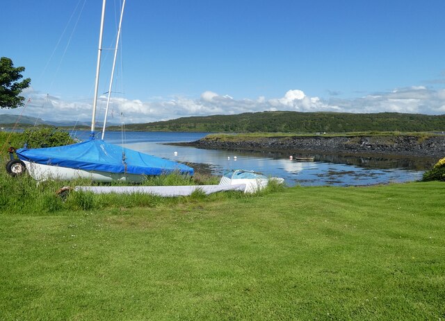
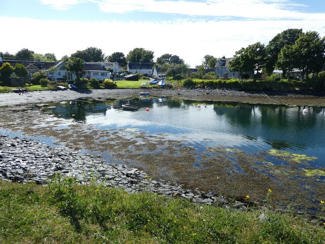
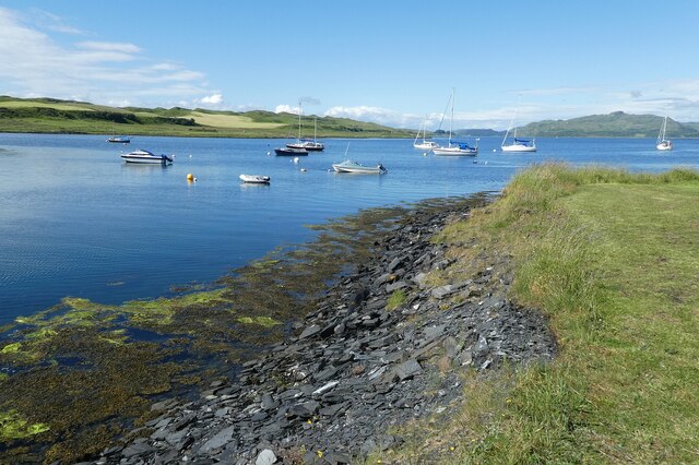
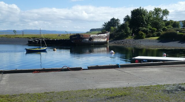
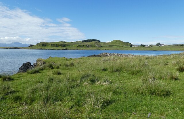
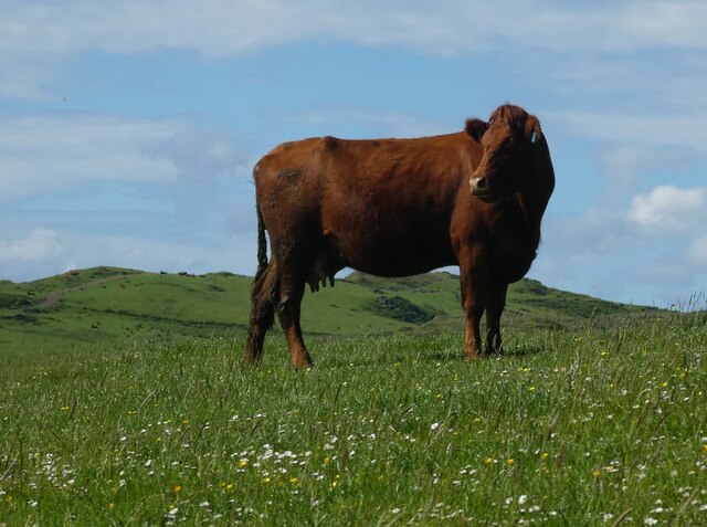
Black Mill Bay is a picturesque coastal destination located in Argyllshire, Scotland. Situated on the western coast, it offers stunning views of the Atlantic Ocean and is surrounded by breathtaking natural beauty. The bay is known for its rugged cliffs, pristine sandy beaches, and crystal-clear turquoise waters.

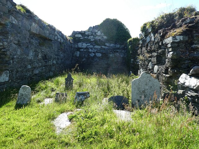
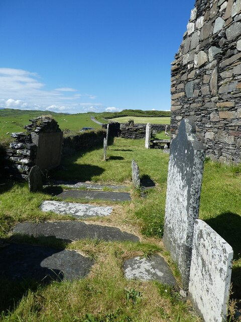
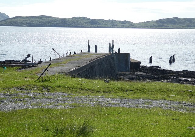
The bay gets its name from the historic black mill, which was once used for grinding grain. Although the mill is no longer operational, its ruins add a touch of charm to the area and serve as a reminder of its rich history. Visitors can explore these ruins and learn about the bay's past.

Black Mill Bay is a haven for outdoor enthusiasts, offering a range of activities. The bay is a popular spot for fishing, with ample opportunities to catch salmon, trout, and other local fish species. It also attracts birdwatchers, as it is home to a variety of seabirds, including gannets, puffins, and cormorants.

The bay's sandy beaches are perfect for leisurely walks and sunbathing, and the clear waters make it an ideal spot for swimming and snorkeling. Additionally, the nearby cliffs provide excellent opportunities for hiking and rock climbing, with stunning panoramic views at the top.

For those seeking a tranquil escape, Black Mill Bay offers a peaceful and serene atmosphere. Its secluded location and unspoiled landscapes make it an ideal destination for relaxation and unwinding amidst nature's beauty.

If you have any feedback on the listing, please let us know in the comments section below.

Black Mill Bay Images

Images are sourced within 2km of 56.213671/-5.6578947 or Grid Reference NM7308. Thanks to Geograph Open Source API. All images are credited.

Luing - Kilchatton - Ruined church and associated graveyard This ruined church stands in its graveyard near to a road junction in the midst of the Isle of Luing just northwest of the village of Toberonochy.
The ruins of the church are a Designated Ancient Monument <span class="nowrap"><a title="http://portal.historicenvironment.scot/designation/SM3808" rel="nofollow ugc noopener" href="http://portal.historicenvironment.scot/designation/SM3808">Link</a><img style="margin-left:2px;" alt="External link" title="External link - shift click to open in new window" src="https://s1.geograph.org.uk/img/external.png" width="10" height="10"/></span> while the graveyard is Category 'B' listed <span class="nowrap"><a title="http://portal.historicenvironment.scot/designation/LB12196" rel="nofollow ugc noopener" href="http://portal.historicenvironment.scot/designation/LB12196">Link</a><img style="margin-left:2px;" alt="External link" title="External link - shift click to open in new window" src="https://s1.geograph.org.uk/img/external.png" width="10" height="10"/></span>
Canmore website information: <span class="nowrap"><a title="https://canmore.org.uk/site/22552/luing-kilchattan-old-parish-church" rel="nofollow ugc noopener" href="https://canmore.org.uk/site/22552/luing-kilchattan-old-parish-church">Link</a><img style="margin-left:2px;" alt="External link" title="External link - shift click to open in new window" src="https://s1.geograph.org.uk/img/external.png" width="10" height="10"/></span>
See also:
<a href="https://www.geograph.org.uk/photo/7258575">NM7409 : Luing - Kilchatton - Ruined church from its graveyard</a>
<a href="https://www.geograph.org.uk/photo/7258583">NM7409 : Luing - Kilchatton ruined church - grave slabs</a>
<a href="https://www.geograph.org.uk/photo/7258588">NM7409 : Luing - Kilchatton - Interior of ruined church</a>
<a href="https://www.geograph.org.uk/photo/7258592">NM7409 : Luing - Kilchatton - Graveyard to the west of ruined church</a>
Luing - Kilchatton - Ruined church and associated graveyard
This ruined church stands in its graveyard near to a road junction in the midst of the Isle of Luing just northwest of the village of Toberonochy. The ruins of the church are a Designated Ancient Monument LinkExternal link while the graveyard is Category 'B' listed LinkExternal link Canmore website information: LinkExternal link See also: NM7409 : Luing - Kilchatton - Ruined church from its graveyard NM7409 : Luing - Kilchatton ruined church - grave slabs NM7409 : Luing - Kilchatton - Interior of ruined church NM7409 : Luing - Kilchatton - Graveyard to the west of ruined church
Luing - Boat in Black Mill Bay This striking little red boat moored in Black Mill Bay on the west coast of the Isle of Luing caught my attention with its almost perfect reflection in the water.
The hill in the background is Cnoc Mòr which rises to 184' (56m).
Luing - Boat in Black Mill Bay
This striking little red boat moored in Black Mill Bay on the west coast of the Isle of Luing caught my attention with its almost perfect reflection in the water. The hill in the background is Cnoc Mòr which rises to 184' (56m).
Luing - Kilchatton - Ruined church from its graveyard Looking at the ruined church at Kilchatton near Toberonochy from the north.
The ruins of the church are a Designated Ancient Monument <span class="nowrap"><a title="http://portal.historicenvironment.scot/designation/SM3808" rel="nofollow ugc noopener" href="http://portal.historicenvironment.scot/designation/SM3808">Link</a><img style="margin-left:2px;" alt="External link" title="External link - shift click to open in new window" src="https://s1.geograph.org.uk/img/external.png" width="10" height="10"/></span> while the graveyard is Category 'B' listed <span class="nowrap"><a title="http://portal.historicenvironment.scot/designation/LB12196" rel="nofollow ugc noopener" href="http://portal.historicenvironment.scot/designation/LB12196">Link</a><img style="margin-left:2px;" alt="External link" title="External link - shift click to open in new window" src="https://s1.geograph.org.uk/img/external.png" width="10" height="10"/></span>
Canmore website information: <span class="nowrap"><a title="https://canmore.org.uk/site/22552/luing-kilchattan-old-parish-church" rel="nofollow ugc noopener" href="https://canmore.org.uk/site/22552/luing-kilchattan-old-parish-church">Link</a><img style="margin-left:2px;" alt="External link" title="External link - shift click to open in new window" src="https://s1.geograph.org.uk/img/external.png" width="10" height="10"/></span>
See also:
<a href="https://www.geograph.org.uk/photo/7218376">NM7409 : Luing - Kilchatton - Ruined church and associated graveyard</a>
<a href="https://www.geograph.org.uk/photo/7258583">NM7409 : Luing - Kilchatton ruined church - grave slabs</a>
<a href="https://www.geograph.org.uk/photo/7258588">NM7409 : Luing - Kilchatton - Interior of ruined church</a>
<a href="https://www.geograph.org.uk/photo/7258592">NM7409 : Luing - Kilchatton - Graveyard to the west of ruined church</a>
Luing - Kilchatton - Ruined church from its graveyard
Looking at the ruined church at Kilchatton near Toberonochy from the north. The ruins of the church are a Designated Ancient Monument LinkExternal link while the graveyard is Category 'B' listed LinkExternal link Canmore website information: LinkExternal link See also: NM7409 : Luing - Kilchatton - Ruined church and associated graveyard NM7409 : Luing - Kilchatton ruined church - grave slabs NM7409 : Luing - Kilchatton - Interior of ruined church NM7409 : Luing - Kilchatton - Graveyard to the west of ruined church
Luing - Kilchatton - Interior of ruined church Looking from the open eastern end of the ruined church at Kilchatton near Toberonochy on the Isle of Luing. The gravestones must post-date the ruination of the church.
See also:
<a href="https://www.geograph.org.uk/photo/7218376">NM7409 : Luing - Kilchatton - Ruined church and associated graveyard</a>
<a href="https://www.geograph.org.uk/photo/7258575">NM7409 : Luing - Kilchatton - Ruined church from its graveyard</a>
<a href="https://www.geograph.org.uk/photo/7258583">NM7409 : Luing - Kilchatton ruined church - grave slabs</a>
<a href="https://www.geograph.org.uk/photo/7258592">NM7409 : Luing - Kilchatton - Graveyard to the west of ruined church</a>
Luing - Kilchatton - Interior of ruined church
Looking from the open eastern end of the ruined church at Kilchatton near Toberonochy on the Isle of Luing. The gravestones must post-date the ruination of the church. See also: NM7409 : Luing - Kilchatton - Ruined church and associated graveyard NM7409 : Luing - Kilchatton - Ruined church from its graveyard NM7409 : Luing - Kilchatton ruined church - grave slabs NM7409 : Luing - Kilchatton - Graveyard to the west of ruined church
Luing - Kilchatton - Graveyard to the west of ruined church Looking along the western end of the ruined church at Kilchatton near Toberonochy on the Isle of Luing, with numerous gravestones between the church and the graveyard wall.
See also:
<a href="https://www.geograph.org.uk/photo/7218376">NM7409 : Luing - Kilchatton - Ruined church and associated graveyard</a>
<a href="https://www.geograph.org.uk/photo/7258575">NM7409 : Luing - Kilchatton - Ruined church from its graveyard</a>
<a href="https://www.geograph.org.uk/photo/7258583">NM7409 : Luing - Kilchatton ruined church - grave slabs</a>
<a href="https://www.geograph.org.uk/photo/7258588">NM7409 : Luing - Kilchatton - Interior of ruined church</a>
Luing - Kilchatton - Graveyard to the west of ruined church
Looking along the western end of the ruined church at Kilchatton near Toberonochy on the Isle of Luing, with numerous gravestones between the church and the graveyard wall. See also: NM7409 : Luing - Kilchatton - Ruined church and associated graveyard NM7409 : Luing - Kilchatton - Ruined church from its graveyard NM7409 : Luing - Kilchatton ruined church - grave slabs NM7409 : Luing - Kilchatton - Interior of ruined church
Luing - Toberonochy - Cottages Most of the older cottages in Toberonochy are Category 'B' listed, including this row of rubble-built cottages.
See listing here: <span class="nowrap"><a title="http://portal.historicenvironment.scot/designation/LB12198" rel="nofollow ugc noopener" href="http://portal.historicenvironment.scot/designation/LB12198">Link</a><img style="margin-left:2px;" alt="External link" title="External link - shift click to open in new window" src="https://s1.geograph.org.uk/img/external.png" width="10" height="10"/></span>
Pretty-much the whole of Toberonochy is a conservation area - see <span class="nowrap"><a title="https://www.argyll-bute.gov.uk/sites/default/files/planning-and-environment/Toberonochy%20Conservation%20Area.pdf" rel="nofollow ugc noopener" href="https://www.argyll-bute.gov.uk/sites/default/files/planning-and-environment/Toberonochy%20Conservation%20Area.pdf">Link</a><img style="margin-left:2px;" alt="External link" title="External link - shift click to open in new window" src="https://s1.geograph.org.uk/img/external.png" width="10" height="10"/></span>
Luing - Toberonochy - Cottages
Most of the older cottages in Toberonochy are Category 'B' listed, including this row of rubble-built cottages. See listing here: LinkExternal link Pretty-much the whole of Toberonochy is a conservation area - see LinkExternal link
Luing - Toberonochy - Beached dinghies A couple of dinghies hauled up beside one of several inlets or quays on the coast by the village of Toberonochy, Luing's second largest settlement after Cullipool.
Luing - Toberonochy - Beached dinghies
A couple of dinghies hauled up beside one of several inlets or quays on the coast by the village of Toberonochy, Luing's second largest settlement after Cullipool.
Luing - Toberonochy - Northern harbour There is quite a large parking area with inlets on either side of it which form Toberonochy Harbour. Houses on the end of this northern inlet have a very pleasant outlook.
Cf. <a href="https://www.geograph.org.uk/photo/7259159">NM7508 : Luing - Toberonochy - Southern harbour</a>
Luing - Toberonochy - Northern harbour
There is quite a large parking area with inlets on either side of it which form Toberonochy Harbour. Houses on the end of this northern inlet have a very pleasant outlook. Cf. NM7508 : Luing - Toberonochy - Southern harbour
Luing - Looking up Shuna Sound from Toberonochy This is a view along the northern section of Shuna Sound from beside Toberonochy Harbour. The land on the left is part of the Isle of Luing, while that on the right is the very lightly populated Isle of Shuna. Although Shuna has just three permanent residents (or some references say one!), there are several holiday properties that can be hired there - see <span class="nowrap"><a title="http://www.islandofshuna.co.uk/Cottages.html" rel="nofollow ugc noopener" href="http://www.islandofshuna.co.uk/Cottages.html">Link</a><img style="margin-left:2px;" alt="External link" title="External link - shift click to open in new window" src="https://s1.geograph.org.uk/img/external.png" width="10" height="10"/></span>
Shuna has an area of 451ha (1,114 acres), taking its population as 3, it has a population density of just 0.7/km2 (1.8/sq mi). Its highest point is Druim na Dubh Ghlaic at 90m (295')
Luing - Looking up Shuna Sound from Toberonochy
This is a view along the northern section of Shuna Sound from beside Toberonochy Harbour. The land on the left is part of the Isle of Luing, while that on the right is the very lightly populated Isle of Shuna. Although Shuna has just three permanent residents (or some references say one!), there are several holiday properties that can be hired there - see LinkExternal link Shuna has an area of 451ha (1,114 acres), taking its population as 3, it has a population density of just 0.7/km2 (1.8/sq mi). Its highest point is Druim na Dubh Ghlaic at 90m (295')
Luing - Toberonochy - Southern harbour The hull of an old boat leans against the western bank of the southern harbour at Toberonochy. Cf. <a href="https://www.geograph.org.uk/photo/7259140">NM7408 : Luing - Toberonochy - Northern harbour</a>
Luing - Toberonochy - Southern harbour
The hull of an old boat leans against the western bank of the southern harbour at Toberonochy. Cf. NM7408 : Luing - Toberonochy - Northern harbour
Luing - Toberonochy - The road out of the village Looking along the street that leads out of the picturesque little village of Toberonochy on the Isle of Luing. Almost the entire village is HES Category 'B' listed - see <span class="nowrap"><a title="http://portal.historicenvironment.scot/designation/LB12198" rel="nofollow ugc noopener" href="http://portal.historicenvironment.scot/designation/LB12198">Link</a><img style="margin-left:2px;" alt="External link" title="External link - shift click to open in new window" src="https://s1.geograph.org.uk/img/external.png" width="10" height="10"/></span>
Luing - Toberonochy - The road out of the village
Looking along the street that leads out of the picturesque little village of Toberonochy on the Isle of Luing. Almost the entire village is HES Category 'B' listed - see LinkExternal link
Luing - Looking across Black Mill Bay to Ardlarach A view across the semicircular Black Mill Bay from the eponymous settlement of Blackmillbay to the land around Ardlarach with Cnoc Mòr rising behind it to the left (west).
Luing - Looking across Black Mill Bay to Ardlarach
A view across the semicircular Black Mill Bay from the eponymous settlement of Blackmillbay to the land around Ardlarach with Cnoc Mòr rising behind it to the left (west).
Luing - Blackmillbay - Jetty The concrete section of this jetty at Blackmillbay on Luing still stands but what looks as though was a wooden continuation of it looks to be long gone. The jetty juts out to the west into the Sound of Luing. The island seen in the distance is Lunga (Population: 0, Area: 250ha (1 mile²), Highest point: Bidean na h-Iolaire 98m (322'))
Luing - Blackmillbay - Jetty
The concrete section of this jetty at Blackmillbay on Luing still stands but what looks as though was a wooden continuation of it looks to be long gone. The jetty juts out to the west into the Sound of Luing. The island seen in the distance is Lunga (Population: 0, Area: 250ha (1 mile²), Highest point: Bidean na h-Iolaire 98m (322'))
Luing - Luing Cattle - a small herd A little group of the good-looking Luing Cattle a breed named after the island. The breed is three quarters Beef Shorthorn and one quarter Highland. They are a very hardy beef cow that can raise their calves in harsh conditions.
See Wikipedia article here: <span class="nowrap"><a title="https://en.wikipedia.org/wiki/Luing_cattle" rel="nofollow ugc noopener" href="https://en.wikipedia.org/wiki/Luing_cattle">Link</a><img style="margin-left:2px;" alt="External link" title="External link - shift click to open in new window" src="https://s1.geograph.org.uk/img/external.png" width="10" height="10"/></span>
Luing Cattle Society webpage here: <span class="nowrap"><a title="https://luingcattlesociety.co.uk" rel="nofollow ugc noopener" href="https://luingcattlesociety.co.uk">Link</a><img style="margin-left:2px;" alt="External link" title="External link - shift click to open in new window" src="https://s1.geograph.org.uk/img/external.png" width="10" height="10"/></span>
See also:
<a href="https://www.geograph.org.uk/photo/7259236">NM7409 : Luing - A small herd of Luing cattle on a ridge</a>
<a href="https://www.geograph.org.uk/photo/7259238">NM7409 : Luing - A Luing cow</a>
Luing - Luing Cattle - a small herd
A little group of the good-looking Luing Cattle a breed named after the island. The breed is three quarters Beef Shorthorn and one quarter Highland. They are a very hardy beef cow that can raise their calves in harsh conditions. See Wikipedia article here: LinkExternal link Luing Cattle Society webpage here: LinkExternal link See also: NM7409 : Luing - A small herd of Luing cattle on a ridge NM7409 : Luing - A Luing cow
Luing - A small herd of Luing cattle on a ridge This little group of the Luing Cattle were moving slowly across the ridge north of the lane from Blackmillbay to Toberonochy on the island from which they get their name.
The breed is three quarters Beef Shorthorn and one quarter Highland. They are a very hardy beef cow that can raise their calves in harsh conditions.
See Wikipedia article here: <span class="nowrap"><a title="https://en.wikipedia.org/wiki/Luing_cattle" rel="nofollow ugc noopener" href="https://en.wikipedia.org/wiki/Luing_cattle">Link</a><img style="margin-left:2px;" alt="External link" title="External link - shift click to open in new window" src="https://s1.geograph.org.uk/img/external.png" width="10" height="10"/></span>
Luing Cattle Society webpage here: <span class="nowrap"><a title="https://luingcattlesociety.co.uk" rel="nofollow ugc noopener" href="https://luingcattlesociety.co.uk">Link</a><img style="margin-left:2px;" alt="External link" title="External link - shift click to open in new window" src="https://s1.geograph.org.uk/img/external.png" width="10" height="10"/></span>
See also:
<a href="https://www.geograph.org.uk/photo/7259232">NM7409 : Luing - Luing Cattle - a small herd</a>
<a href="https://www.geograph.org.uk/photo/7259238">NM7409 : Luing - A Luing cow</a>
Luing - A small herd of Luing cattle on a ridge
This little group of the Luing Cattle were moving slowly across the ridge north of the lane from Blackmillbay to Toberonochy on the island from which they get their name. The breed is three quarters Beef Shorthorn and one quarter Highland. They are a very hardy beef cow that can raise their calves in harsh conditions. See Wikipedia article here: LinkExternal link Luing Cattle Society webpage here: LinkExternal link See also: NM7409 : Luing - Luing Cattle - a small herd NM7409 : Luing - A Luing cow
Luing - A Luing cow This fine beast was munching on the grassland of the Isle of Luing from which the breed gets its name.
The breed is three quarters Beef Shorthorn and one quarter Highland. They are a very hardy beef cow that can raise their calves in harsh conditions.
See Wikipedia article here: <span class="nowrap"><a title="https://en.wikipedia.org/wiki/Luing_cattle" rel="nofollow ugc noopener" href="https://en.wikipedia.org/wiki/Luing_cattle">Link</a><img style="margin-left:2px;" alt="External link" title="External link - shift click to open in new window" src="https://s1.geograph.org.uk/img/external.png" width="10" height="10"/></span>
Luing Cattle Society webpage here: <span class="nowrap"><a title="https://luingcattlesociety.co.uk" rel="nofollow ugc noopener" href="https://luingcattlesociety.co.uk">Link</a><img style="margin-left:2px;" alt="External link" title="External link - shift click to open in new window" src="https://s1.geograph.org.uk/img/external.png" width="10" height="10"/></span>
See also:
<a href="https://www.geograph.org.uk/photo/7259232">NM7409 : Luing - Luing Cattle - a small herd</a>
<a href="https://www.geograph.org.uk/photo/7259236">NM7409 : Luing - A small herd of Luing cattle on a ridge</a>
Luing - A Luing cow
This fine beast was munching on the grassland of the Isle of Luing from which the breed gets its name. The breed is three quarters Beef Shorthorn and one quarter Highland. They are a very hardy beef cow that can raise their calves in harsh conditions. See Wikipedia article here: LinkExternal link Luing Cattle Society webpage here: LinkExternal link See also: NM7409 : Luing - Luing Cattle - a small herd NM7409 : Luing - A small herd of Luing cattle on a ridge
Blackmill Bay, Luing
Show me another place!

Black Mill Bay is located at Grid Ref: NM7308 (Lat: 56.213671, Lng: -5.6578947)

Unitary Authority: Argyll and Bute

Police Authority: Argyll and West Dunbartonshire

What 3 Words

///glitz.lengthen.gravitate. Near Lochbuie, Argyll & Bute

Related Wikis

Luing

Luing ( LING; Scottish Gaelic: Luinn) is one of the Slate Islands, Firth of Lorn, in the west of Argyll in Scotland, about 16 miles (26 km) south of Oban...

Ardinamir

Ardinamir is an anchorage and small settlement on the island of Luing in Argyll and Bute, Scotland. == References ==

Lunga, Firth of Lorn

Lunga is one of the Slate Islands in the Firth of Lorn in Argyll and Bute, Scotland. The "Grey Dog" tidal race, which runs in the sea channel to the south...

Scarba, Lunga and the Garvellachs National Scenic Area

Scarba, Lunga and the Garvellachs is the name of one of the 40 national scenic areas of Scotland. The designated area covers the islands of Scarba, Lunga...

Related Videos

Isle of Luing (4K)

Another short ferry crossing, and another island bagged. In this video, I show the villages of Cullipool and Toberonochy as well as ...

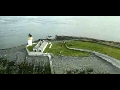
Lighthouse Islet Of Fladda On Visit To Sound Of Luing Scotland

Tour Scotland travel video clip, with Scottish music, of the lighthouse on the Islet Of Fladda on ancestry visit to the Sound Of Luing.

Nearby Amenities

Located within 500m of 56.213671,-5.6578947
Source: PGS
Lat/Long: 56.209556/-5.6550931
Source: PGS
Lat/Long: 56.2100695/-5.6547508
Source: PGS
Lat/Long: 56.2101206/-5.6553286
Source: PGS
Lat/Long: 56.2102256/-5.6555713
Source: PGS
Lat/Long: 56.2103582/-5.6557575
Source: PGS
Lat/Long: 56.2106196/-5.6559643
Source: PGS
Lat/Long: 56.2107415/-5.6560964
Source: PGS
Lat/Long: 56.2108559/-5.6564888
Source: PGS
Lat/Long: 56.2108856/-5.6565706
Source: PGS
Lat/Long: 56.2114106/-5.6574017
Source: PGS
Lat/Long: 56.2114779/-5.6575774
Source: PGS
Lat/Long: 56.2118919/-5.6579776
Source: PGS
Lat/Long: 56.211983/-5.6580841
Source: PGS
Lat/Long: 56.212231/-5.6588952
Source: PGS
Lat/Long: 56.2127927/-5.6589897
Source: PGS
Lat/Long: 56.2130031/-5.6589886
Source: PGS
Lat/Long: 56.2132772/-5.6592314
Source: PGS
Lat/Long: 56.2133917/-5.659393
Source: PGS
Lat/Long: 56.2135181/-5.6596493
Source: PGS
Lat/Long: 56.2136504/-5.6593337
Source: PGS
Lat/Long: 56.2144988/-5.6587564
Source: PGS
Lat/Long: 56.2145524/-5.6579946
Source: PGS
Lat/Long: 56.2144571/-5.6574228
Source: PGS
Lat/Long: 56.2144685/-5.6571709
Source: PGS
Lat/Long: 56.215059/-5.6563153
Source: PGS
Lat/Long: 56.2164789/-5.6564117
Source: PGS
Lat/Long: 56.2171461/-5.6571838
Source: PGS
Lat/Long: 56.2171722/-5.6575056
Source: PGS
Lat/Long: 56.2171127/-5.6588689
Source: PGS
Lat/Long: 56.217137/-5.6606621
Source: PGS
Lat/Long: 56.2173656/-5.6614956
Source: PGS
Lat/Long: 56.2175168/-5.6619094
Disused: yes
Man Made: pier
Lat/Long: 56.2135034/-5.6593442
Post Box
Collection Times: Mo-Fr 09:00; Sa 09:00
Operator: Royal Mail
Post Box Manufacturer: Machan, Scotland
Post Box Type: lamp
Ref: PA34 65
Royal Cypher: scottish_crown
Lat/Long: 56.2138125/-5.6577494
Blackmill Bay
Place: hamlet
Lat/Long: 56.2133337/-5.6584483
Power: pole
Lat/Long: 56.215386/-5.6511076
Power: pole
Lat/Long: 56.215277/-5.6524234
Power: pole
Lat/Long: 56.2151752/-5.6536434
Power: pole
Lat/Long: 56.2150698/-5.6548677
Power: pole
Lat/Long: 56.2145998/-5.6558001
Power: pole
Lat/Long: 56.2141467/-5.6567085
Power: pole
Lat/Long: 56.213673/-5.6576714
Power: pole
Lat/Long: 56.2132005/-5.6585646
The data included in this document is from www.openstreetmap.org. The data is made available under ODbL.

Have you been to Black Mill Bay?

Leave your review of Black Mill Bay below (or comments, questions and feedback).