Birichen

Settlement in Sutherland

Scotland

Birichen

Road Bridge over the River Evelix, Sutherland A quiet rural corner, near Dornoch, in the Scottish Highlands.
Road Bridge over the River Evelix, Sutherland Credit: Andrew Tryon

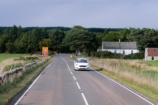
Birichen is a small village located in the county of Sutherland, in the Highland region of Scotland. Situated on the eastern shores of Loch Shin, the village is surrounded by picturesque landscapes and offers a tranquil and rural atmosphere.

The village itself is home to a small population, primarily engaged in agricultural activities and tourism-related businesses. The traditional stone cottages and farmhouses add to the charm of Birichen, showcasing the area's rich history and heritage.

One of the main attractions in Birichen is the nearby Falls of Shin, a popular spot for visitors. This waterfall on the River Shin is renowned for its salmon leaping, attracting tourists from all over the world. The surrounding countryside offers numerous opportunities for outdoor activities such as hiking, fishing, and birdwatching.

Despite its small size, Birichen benefits from its proximity to nearby towns such as Lairg and Bonar Bridge, where residents can access a wider range of amenities and services. The village is well-connected by road, making it easily accessible for both residents and visitors.

The remote location of Birichen also offers stunning views of the Scottish Highlands, with Ben Wyvis and Ben Klibreck being visible on clear days. The tranquility and natural beauty of Birichen make it an ideal place for those seeking a peaceful and rural lifestyle in the heart of the Scottish Highlands.

If you have any feedback on the listing, please let us know in the comments section below.

Birichen Images

Images are sourced within 2km of 57.9045/-4.1018409 or Grid Reference NH7592. Thanks to Geograph Open Source API. All images are credited.

Road Bridge over the River Evelix, Sutherland A quiet rural corner, near Dornoch, in the Scottish Highlands.
Road Bridge over the River Evelix, Sutherland
A quiet rural corner, near Dornoch, in the Scottish Highlands.
Northbound A9 near Evelix Presbyterian Church The A9 is a strategic link between the Highlands of Scotland and the Central Belt. Running for 273 miles, it is the longest road in Scotland and the fifth-longest A-road in the United Kingdom. Historically it was the main road between Edinburgh and John o' Groats but its importance has been eclipsed somewhat in the south by the A90 across the Forth Road Bridge and the M90 motorway, which now links Edinburgh more directly with Perth, and the M9, which is now the main road between Edinburgh and Bridge of Allan.
Northbound A9 near Evelix Presbyterian Church
The A9 is a strategic link between the Highlands of Scotland and the Central Belt. Running for 273 miles, it is the longest road in Scotland and the fifth-longest A-road in the United Kingdom. Historically it was the main road between Edinburgh and John o' Groats but its importance has been eclipsed somewhat in the south by the A90 across the Forth Road Bridge and the M90 motorway, which now links Edinburgh more directly with Perth, and the M9, which is now the main road between Edinburgh and Bridge of Allan.
A9 near Proncy The A9 is a strategic link between the Highlands of Scotland and the Central Belt. Running for 273 miles, it is the longest road in Scotland and the fifth-longest A-road in the United Kingdom. Historically it was the main road between Edinburgh and John o' Groats but its importance has been eclipsed somewhat in the south by the A90 across the Forth Road Bridge and the M90 motorway, which now links Edinburgh more directly with Perth, and the M9, which is now the main road between Edinburgh and Bridge of Allan.
A9 near Proncy
The A9 is a strategic link between the Highlands of Scotland and the Central Belt. Running for 273 miles, it is the longest road in Scotland and the fifth-longest A-road in the United Kingdom. Historically it was the main road between Edinburgh and John o' Groats but its importance has been eclipsed somewhat in the south by the A90 across the Forth Road Bridge and the M90 motorway, which now links Edinburgh more directly with Perth, and the M9, which is now the main road between Edinburgh and Bridge of Allan.
Northbound A9 near Proncy Cottage The A9 is a strategic link between the Highlands of Scotland and the Central Belt. Running for 273 miles, it is the longest road in Scotland and the fifth-longest A-road in the United Kingdom. Historically it was the main road between Edinburgh and John o' Groats but its importance has been eclipsed somewhat in the south by the A90 across the Forth Road Bridge and the M90 motorway, which now links Edinburgh more directly with Perth, and the M9, which is now the main road between Edinburgh and Bridge of Allan.
Northbound A9 near Proncy Cottage
The A9 is a strategic link between the Highlands of Scotland and the Central Belt. Running for 273 miles, it is the longest road in Scotland and the fifth-longest A-road in the United Kingdom. Historically it was the main road between Edinburgh and John o' Groats but its importance has been eclipsed somewhat in the south by the A90 across the Forth Road Bridge and the M90 motorway, which now links Edinburgh more directly with Perth, and the M9, which is now the main road between Edinburgh and Bridge of Allan.
Signage A9 northbound near Evelix
Entrance to Proncy Cottage - A9 northbound
Minor road near Astle
Minor road view
Minor road view
Minor road view
Minor road view
Minor road view
Minor road view
Minor road view
Minor road view
Minor road view
Minor road view
Minor road view
Minor road view
Minor road view
Minor road view
Minor road view
Minor road view
Minor road view
Minor road view
Show me another place!

Birichen is located at Grid Ref: NH7592 (Lat: 57.9045, Lng: -4.1018409)

Unitary Authority: Highland

Police Authority: Highlands and Islands

What 3 Words

///patio.community.violin. Near Dornoch, Highland

Nearby Locations

Lednabirichen Birichen

Related Wikis

Rearquhar

Rearquhar is a township, which lies in the valley of the River Evelix, 4 miles northwest from Dornoch, in Sutherland, Scottish Highlands and is in the...

Achavandra Muir

Achavandra Muir (Scottish Gaelic: Achadh Anndra - Andrew's Field) is a hamlet in the Scottish Highlands in northeastern Scotland, about 7 kilometres from...

Evelix

Evelix or Evelick (Scottish Gaelic: Èibhleag) is a village near Dornoch in south east Sutherland, Scotland. The River Evelix runs through it. Evelix is...

Badninish

Badninish is a small crofting hamlet in Dornoch, Sutherland, Highland, Scotland. == References ==

Proncycroy

Proncycroy (Scottish Gaelic: Prannsaidh Cruaidh) is a settlement in the Sutherland region in the Scottish council area of Highland, and is located less...

Camore

Camore (Scottish Gaelic: An Cadha Mòr) is a small hamlet, located 0.5 mile directly southeast of Evelix, and 1.5 miles west of Dornoch, in south east Sutherland...

Skibo Castle

Skibo Castle (Scottish Gaelic: Caisteal Sgìobail) is located to the west of Dornoch in the Highland county of Sutherland, Scotland overlooking the Dornoch...

Dornoch Academy

Dornoch Academy (Scottish Gaelic: Acadamaidh Dhornaich) is a state secondary school situated in the small town of Dornoch in Sutherland in northern Scotland...

Nearby Amenities

Located within 500m of 57.9045,-4.1018409
Power: pole
Lat/Long: 57.9050787/-4.0975056
Power: pole
Lat/Long: 57.9044983/-4.0976802
Power: pole
Lat/Long: 57.9037086/-4.0979523
Power: pole
Lat/Long: 57.9032425/-4.0981046
Power: pole
Lat/Long: 57.9027624/-4.098265
Power: pole
Lat/Long: 57.9022753/-4.0984223
Power: pole
Lat/Long: 57.9017888/-4.0985787
Power: pole
Lat/Long: 57.9011544/-4.0986924
Power: pole
Lat/Long: 57.9030883/-4.097134
Power: pole
Lat/Long: 57.9029815/-4.0964457
Power: pole
Lat/Long: 57.9028121/-4.0954285
Power: pole
Lat/Long: 57.9026287/-4.0942651
Power: pole
Lat/Long: 57.9034416/-4.0993685
Power: pole
Lat/Long: 57.903639/-4.1006294
Power: pole
Lat/Long: 57.9038224/-4.1018334
Power: pole
Lat/Long: 57.9039519/-4.1025887
Power: pole
Lat/Long: 57.9041428/-4.1037582
Power: pole
Lat/Long: 57.9043349/-4.1049927
Power: pole
Lat/Long: 57.9045258/-4.1061581
Power: pole
Lat/Long: 57.9047151/-4.107354
Power: pole
Lat/Long: 57.9049018/-4.1085519
Power: pole
Lat/Long: 57.9050938/-4.109758
Power: pole
Lat/Long: 57.9056397/-4.1089824
Power: pole
Lat/Long: 57.9027144/-4.0998537
Power: pole
Lat/Long: 57.9011619/-4.1008649
Power: pole
Lat/Long: 57.9010896/-4.099801
Power: pole
Lat/Long: 57.901054/-4.0975269
Lednabirichen
Name Gd: Leathad na Bioraichean
Place: locality
Lat/Long: 57.9070393/-4.0970639
The data included in this document is from www.openstreetmap.org. The data is made available under ODbL.

Have you been to Birichen?

Leave your review of Birichen below (or comments, questions and feedback).