Beckering

Settlement in Lincolnshire West Lindsey

England

Beckering

Ridge and furrow in Holton cum Beckering: aerial 2021 (1) The field is not mentioned specifically but would seem to be part of the Deserted Medieval Village of Beckering 500m to the SE - <span class="nowrap"><a title="https://www.heritagegateway.org.uk/Gateway/Results_Single.aspx?uid=MLI53237&resourceID=1006" rel="nofollow ugc noopener" href="https://www.heritagegateway.org.uk/Gateway/Results_Single.aspx?uid=MLI53237&resourceID=1006">Link</a><img style="margin-left:2px;" alt="External link" title="External link - shift click to open in new window" src="https://s1.geograph.org.uk/img/external.png" width="10" height="10"/></span>

See also <span class="nowrap"><a title="https://www.heritagegateway.org.uk/Gateway/Results_Single.aspx?uid=MLI53234&resourceID=1006" rel="nofollow ugc noopener" href="https://www.heritagegateway.org.uk/Gateway/Results_Single.aspx?uid=MLI53234&resourceID=1006">Link</a><img style="margin-left:2px;" alt="External link" title="External link - shift click to open in new window" src="https://s1.geograph.org.uk/img/external.png" width="10" height="10"/></span>
Ridge and furrow in Holton cum Beckering: aerial 2021 (1) Credit: Chris

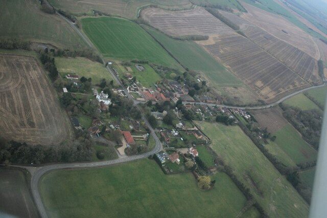
Beckering is a small village located in the county of Lincolnshire, England. It is situated about 7 miles north of the town of Market Rasen and is part of the West Lindsey district. The village lies in a rural setting, surrounded by picturesque countryside and farmland.

With a population of approximately 200 residents, Beckering has a close-knit community that enjoys a peaceful and tranquil lifestyle. The village is known for its charming and well-preserved traditional architecture, with many buildings dating back to the 18th and 19th centuries.

Although small in size, Beckering offers a range of amenities to its residents. These include a local pub, a village hall, and a small convenience store for everyday needs. For more extensive shopping and leisure facilities, nearby towns like Market Rasen provide a wider range of options.

The village is well-connected to the surrounding areas by road, with the A46 running nearby, offering convenient access to Lincoln and Grimsby. The nearest railway station is in Market Rasen, providing regular services to other major cities in the region.

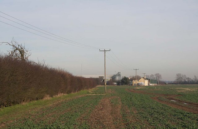
Beckering is surrounded by beautiful countryside, making it an ideal location for outdoor enthusiasts. The area offers numerous walking and cycling routes, allowing residents and visitors to explore the scenic landscapes and enjoy the tranquility of the rural setting.

In summary, Beckering is a peaceful and picturesque village in Lincolnshire, offering a close-knit community and easy access to both rural and urban amenities.

If you have any feedback on the listing, please let us know in the comments section below.

Beckering Images

Images are sourced within 2km of 53.309822/-0.31795551 or Grid Reference TF1280. Thanks to Geograph Open Source API. All images are credited.

Ridge and furrow in Holton cum Beckering: aerial 2021 (1) The field is not mentioned specifically but would seem to be part of the Deserted Medieval Village of Beckering 500m to the SE - <span class="nowrap"><a title="https://www.heritagegateway.org.uk/Gateway/Results_Single.aspx?uid=MLI53237&resourceID=1006" rel="nofollow ugc noopener" href="https://www.heritagegateway.org.uk/Gateway/Results_Single.aspx?uid=MLI53237&resourceID=1006">Link</a><img style="margin-left:2px;" alt="External link" title="External link - shift click to open in new window" src="https://s1.geograph.org.uk/img/external.png" width="10" height="10"/></span>

See also <span class="nowrap"><a title="https://www.heritagegateway.org.uk/Gateway/Results_Single.aspx?uid=MLI53234&resourceID=1006" rel="nofollow ugc noopener" href="https://www.heritagegateway.org.uk/Gateway/Results_Single.aspx?uid=MLI53234&resourceID=1006">Link</a><img style="margin-left:2px;" alt="External link" title="External link - shift click to open in new window" src="https://s1.geograph.org.uk/img/external.png" width="10" height="10"/></span>
Ridge and furrow in Holton cum Beckering: aerial 2021 (1)
The field is not mentioned specifically but would seem to be part of the Deserted Medieval Village of Beckering 500m to the SE - LinkExternal link See also LinkExternal link
Ridge and furrow in Holton cum Beckering: aerial 2021 (2) The field is not mentioned specifically but would seem to be part of the Deserted Medieval Village of Beckering 500m to the SE - <span class="nowrap"><a title="https://www.heritagegateway.org.uk/Gateway/Results_Single.aspx?uid=MLI53237&resourceID=1006" rel="nofollow ugc noopener" href="https://www.heritagegateway.org.uk/Gateway/Results_Single.aspx?uid=MLI53237&resourceID=1006">Link</a><img style="margin-left:2px;" alt="External link" title="External link - shift click to open in new window" src="https://s1.geograph.org.uk/img/external.png" width="10" height="10"/></span>

See also <span class="nowrap"><a title="https://www.heritagegateway.org.uk/Gateway/Results_Single.aspx?uid=MLI53234&resourceID=1006" rel="nofollow ugc noopener" href="https://www.heritagegateway.org.uk/Gateway/Results_Single.aspx?uid=MLI53234&resourceID=1006">Link</a><img style="margin-left:2px;" alt="External link" title="External link - shift click to open in new window" src="https://s1.geograph.org.uk/img/external.png" width="10" height="10"/></span>
Ridge and furrow in Holton cum Beckering: aerial 2021 (2)
The field is not mentioned specifically but would seem to be part of the Deserted Medieval Village of Beckering 500m to the SE - LinkExternal link See also LinkExternal link
All Saints Church, Holton Cum Beckering
Beckering DMV, Holton cum Beckering: aerial 2023 The earthworks seem to have been systematically destroyed in 1963 and 1975.

See: <span class="nowrap"><a title="https://www.heritagegateway.org.uk/Gateway/Results_Single.aspx?uid=MLI53237&resourceID=1006" rel="nofollow ugc noopener" href="https://www.heritagegateway.org.uk/Gateway/Results_Single.aspx?uid=MLI53237&resourceID=1006">Link</a><img style="margin-left:2px;" alt="External link" title="External link - shift click to open in new window" src="https://s1.geograph.org.uk/img/external.png" width="10" height="10"/></span>
Beckering DMV, Holton cum Beckering: aerial 2023
The earthworks seem to have been systematically destroyed in 1963 and 1975. See: LinkExternal link
Holton cum Beckering: aerial 2023 Settlement of Holton: <span class="nowrap"><a title="https://www.heritagegateway.org.uk/Gateway/Results_Single.aspx?uid=MLI53233&resourceID=1006" rel="nofollow ugc noopener" href="https://www.heritagegateway.org.uk/Gateway/Results_Single.aspx?uid=MLI53233&resourceID=1006">Link</a><img style="margin-left:2px;" alt="External link" title="External link - shift click to open in new window" src="https://s1.geograph.org.uk/img/external.png" width="10" height="10"/></span>

Post Medieval Settlement of Holton: <span class="nowrap"><a title="https://www.heritagegateway.org.uk/Gateway/Results_Single.aspx?uid=MLI53234&resourceID=1006" rel="nofollow ugc noopener" href="https://www.heritagegateway.org.uk/Gateway/Results_Single.aspx?uid=MLI53234&resourceID=1006">Link</a><img style="margin-left:2px;" alt="External link" title="External link - shift click to open in new window" src="https://s1.geograph.org.uk/img/external.png" width="10" height="10"/></span>

Site of Grange of Sixhills Priory: <span class="nowrap"><a title="https://www.heritagegateway.org.uk/Gateway/Results_Single.aspx?uid=MLI53235&resourceID=1006" rel="nofollow ugc noopener" href="https://www.heritagegateway.org.uk/Gateway/Results_Single.aspx?uid=MLI53235&resourceID=1006">Link</a><img style="margin-left:2px;" alt="External link" title="External link - shift click to open in new window" src="https://s1.geograph.org.uk/img/external.png" width="10" height="10"/></span>
Holton cum Beckering: aerial 2023
Settlement of Holton: LinkExternal link Post Medieval Settlement of Holton: LinkExternal link Site of Grange of Sixhills Priory: LinkExternal link
Rand Hall Farm At the photographer's viewpoint the lane is marked as Roman Road on the 1:25000
Rand Hall Farm
At the photographer's viewpoint the lane is marked as Roman Road on the 1:25000
Bush Farm near Holton
Barn Farm near Holton
Chancel arch conundrum Looking east in St.Oswald's church, the chancel arch is 13th century but the capitals look 15th century ..... presumably re-used from elsewhere during the rebuilding of the nave in 1820 and the chancel in 1862
Chancel arch conundrum
Looking east in St.Oswald's church, the chancel arch is 13th century but the capitals look 15th century ..... presumably re-used from elsewhere during the rebuilding of the nave in 1820 and the chancel in 1862
An unknown medieval lady Monument to an unknown late 13th century lady in the chancel of St.Oswald's church
An unknown medieval lady
Monument to an unknown late 13th century lady in the chancel of St.Oswald's church
Barns and implement sheds, Lincoln Road, Holton cum Beckering
Twisted tree by Holton Hall, Holton cum Beckering
Barns, Lincoln Road, Holton cum Beckering
Bridge over unnamed drain,Wragby Road, Beckering
Building work near Abbey Farm, Beckering
Interior, All Saints' church, Holton Cum Beckering Grade I listed.
The oldest part of the church dates back to the 13th century.  The church was enlarged during the 15th century and later had restoration work done under Sir George Gilbert Scott in the 19th century. The arcade – most of the windows and the south porch date from this time.  The octagonal font is 13th/15 century.  The wrought iron top is modern.
The church has north and south aisles and a north chapel.
The late 13th C 3 bay arcades have double chamfered arches with octagonal piers and moulded capitals. On the voussoirs are extensive traces of red painted foliage.
The lower part of the tower is 13th century and retains the original narrow tower arch and small lancet window in the west wall.  The upper tower was added in the 14th century together with the window.
The reredos dated 1860 is mosaic and marble and displays Italian workmanship.
Restoration dates of interest:-
1851 WA Nicholson – Architect – work undertaken in chancel included the painted ceiling
1859-60 Sir George G Scott – further restoration
1867 Reredos designed by RJ Withers and made by Salviati
1870-74 George G Scott Jnr, urgent restoration work.
Interior, All Saints' church, Holton Cum Beckering
Grade I listed. The oldest part of the church dates back to the 13th century. The church was enlarged during the 15th century and later had restoration work done under Sir George Gilbert Scott in the 19th century. The arcade – most of the windows and the south porch date from this time. The octagonal font is 13th/15 century. The wrought iron top is modern. The church has north and south aisles and a north chapel. The late 13th C 3 bay arcades have double chamfered arches with octagonal piers and moulded capitals. On the voussoirs are extensive traces of red painted foliage. The lower part of the tower is 13th century and retains the original narrow tower arch and small lancet window in the west wall. The upper tower was added in the 14th century together with the window. The reredos dated 1860 is mosaic and marble and displays Italian workmanship. Restoration dates of interest:- 1851 WA Nicholson – Architect – work undertaken in chancel included the painted ceiling 1859-60 Sir George G Scott – further restoration 1867 Reredos designed by RJ Withers and made by Salviati 1870-74 George G Scott Jnr, urgent restoration work.
Stained glass window, All Saints' church, Holton Cum Beckering A crucifixion scene.
Stained glass window, All Saints' church, Holton Cum Beckering
A crucifixion scene.
East Window, All Saints' church, Holton Cum Beckering A Te Deum window.
East Window, All Saints' church, Holton Cum Beckering
A Te Deum window.
Show me another place!

Beckering is located at Grid Ref: TF1280 (Lat: 53.309822, Lng: -0.31795551)

Division: Parts of Lindsey

Administrative County: Lincolnshire

District: West Lindsey

Police Authority: Lincolnshire

What 3 Words

///unwell.hobbit.commuting. Near Wragby, Lincolnshire

Nearby Locations

Beckering

Related Wikis

Holton cum Beckering

Holton cum Beckering is a small village and civil parish in West Lindsey, Lincolnshire, England. It is situated 6 miles (10 km) south from Market Rasen...

West Torrington

West Torrington is a small hamlet in the East Lindsey district of Lincolnshire, England. It is situated on the edge of Bleasby Moor and 3 miles (4.8 km...

RAF Wickenby

Royal Air Force Wickenby, or more simply RAF Wickenby, was a purpose-built Royal Air Force satellite station constructed late 1942 and early 1943. It lies...

Wickenby Aerodrome

Wickenby Aerodrome (ICAO: EGNW) is an airport 8 NM (15 km; 9.2 mi) nautical miles north-east of Lincoln, Lincolnshire, England.Wickenby Aerodrome has a...

Rand, Lincolnshire

Rand is a small village and civil parish in the West Lindsey district of Lincolnshire, England. It is situated approximately 9 miles (14 km) north-east...

Fulnetby

Fulnetby is a hamlet and civil parish in the West Lindsey district of Lincolnshire, England. It is situated approximately 8 miles (13 km) north-east from...

Wragby

Wragby ( RAG-bee) is a town and civil parish in the East Lindsey district of Lincolnshire, England. It is situated at the junction of the A157 and A158...

St George's Church, Goltho

St George's Church is a redundant Anglican church in the deserted village of Goltho, Lincolnshire, England. It is recorded in the National Heritage List...

Nearby Amenities

Located within 500m of 53.309822,-0.31795551
Holton Cum Beckering
Is In: Lincolnshire, England, UK
Place: hamlet
Source: Bing
Wikidata: Q2787918
Lat/Long: 53.3109607/-0.3188248
Abbey Farm
Place: farm
Source: Bing
Lat/Long: 53.3123012/-0.3179068
Power: pole
Lat/Long: 53.3135759/-0.3169804
Power: pole
Lat/Long: 53.3066465/-0.3169074
Power: pole
Lat/Long: 53.3073474/-0.316858
Power: pole
Lat/Long: 53.3074654/-0.3125508
Power: pole
Lat/Long: 53.307912/-0.3139545
Power: pole
Lat/Long: 53.3080645/-0.3168086
Power: pole
Lat/Long: 53.308364/-0.3154101
Power: pole
Lat/Long: 53.3087949/-0.3167861
Power: pole
Lat/Long: 53.3092318/-0.3181472
Power: pole
Lat/Long: 53.3096462/-0.316831
Power: pole
Lat/Long: 53.3103481/-0.3168542
Power: pole
Lat/Long: 53.3110525/-0.3169083
Power: pole
Lat/Long: 53.3118823/-0.3169242
Power: pole
Lat/Long: 53.3127273/-0.3169496
The data included in this document is from www.openstreetmap.org. The data is made available under ODbL.

Have you been to Beckering?

Leave your review of Beckering below (or comments, questions and feedback).