Badbury

Settlement in Somerset South Somerset

England

Badbury

St. Mary the Virgin, Isle Abbotts, Somerset A 13th Century, Grade I listed building having had several restorations since.
St. Mary the Virgin, Isle Abbotts, Somerset Credit: Ray Jennings

Badbury is a small village located in the county of Somerset, England. Situated on the outskirts of the larger town of Yeovil, Badbury is known for its picturesque countryside and tranquil atmosphere. The village is nestled in the heart of the South Somerset district, offering residents and visitors easy access to the stunning landscapes and rural charm that the region is famous for.

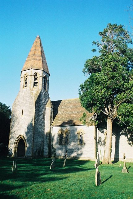
The village of Badbury is home to a tight-knit community, with a population of around 500 residents. The area is characterized by its traditional stone cottages and historic buildings, which add to the village's charm and character. The local parish church, St. Mary's, is a notable architectural landmark, dating back several centuries and attracting history enthusiasts.

Although small in size, Badbury boasts various amenities to cater to its residents. These include a village hall, a local pub, and a small convenience store, providing essential goods and services. Recreational activities are abundant in the area, with numerous walking and cycling trails that allow residents and visitors to explore the surrounding countryside.

Badbury's location offers convenient access to nearby towns and cities, making it an ideal base for commuters. The village is approximately 25 miles from Taunton and 35 miles from Bath, providing residents with easy access to a wider range of amenities and employment opportunities.

Overall, Badbury, Somerset, is a charming village that offers a peaceful and rural lifestyle, making it an attractive place to live for those seeking a slower pace of life amidst beautiful countryside surroundings.

If you have any feedback on the listing, please let us know in the comments section below.

Badbury Images

Images are sourced within 2km of 50.97575/-2.9266151 or Grid Reference ST3520. Thanks to Geograph Open Source API. All images are credited.

St. Mary the Virgin, Isle Abbotts, Somerset A 13th Century, Grade I listed building having had several restorations since.
St. Mary the Virgin, Isle Abbotts, Somerset
A 13th Century, Grade I listed building having had several restorations since.
St. Mary the Virgin, Isle Abbotts, Somerset The Nave.
St. Mary the Virgin, Isle Abbotts, Somerset
The Nave.
Field Near Salstons There is very little in this rural square except fields and a few country lanes. The roller is in a field just off the minor road that runs from Curry Mallet to Fivehead.
Field Near Salstons
There is very little in this rural square except fields and a few country lanes. The roller is in a field just off the minor road that runs from Curry Mallet to Fivehead.
Field Near Morells This is the view across the field next to Morells which is the white house visible in the distance and which is in the next grid square ST3321. The house is next to the minor road running from Curry Mallet to Fivehead. The road is behind the hedge on the right.
Field Near Morells
This is the view across the field next to Morells which is the white house visible in the distance and which is in the next grid square ST3321. The house is next to the minor road running from Curry Mallet to Fivehead. The road is behind the hedge on the right.
Farm Track This is the start of the farm track that leads from Isle Abbotts to Curry Mallet across the floodplain of the Fivehead River.
Farm Track
This is the start of the farm track that leads from Isle Abbotts to Curry Mallet across the floodplain of the Fivehead River.
Country lane, Isle Brewers
Runway 34 RNAS Merryfield This picture was taken during the Somerset Centenary Scout Camp at RNAS Merryfield. The tanker is a water bowser.
Runway 34 RNAS Merryfield
This picture was taken during the Somerset Centenary Scout Camp at RNAS Merryfield. The tanker is a water bowser.
Control Tower, RNAS Merryfield Taken during the Somerset Centenary Scout Camp, which explains the caravans obstructing the plain military view.
Control Tower, RNAS Merryfield
Taken during the Somerset Centenary Scout Camp, which explains the caravans obstructing the plain military view.
Flying flagpole A typical bit of scout trickery from the Somerset Centenary Scout Camp at RNAS Merryfield. Rather let down by the use of staples instead of knots ...
Flying flagpole
A typical bit of scout trickery from the Somerset Centenary Scout Camp at RNAS Merryfield. Rather let down by the use of staples instead of knots ...
Runway 27 RNAS Merryfield Runway 27 at RNAS Merryfield. The obstructions to aircraft are scouts attending the Somerset Centenary Scout Camp.
Runway 27 RNAS Merryfield
Runway 27 at RNAS Merryfield. The obstructions to aircraft are scouts attending the Somerset Centenary Scout Camp.
Bridge over the River Isle, near Bradon Farm
River Isle from bridge, near Bradon Farm
Royal Navy personnel practice fire drill on Merryfield airfield
RN Air Traffic Control officer and former RAF serviceman stand in woodland clearing used for helicopter training at Merryfield
Gazelle helicopter approaching Merryfield airfield Flying in from the east, an Army Air Corps Gazelle helicopter approaches the main runway at Merryfield during a large military exercise. This view, looking roughly ESE, shows open fields on the other side of the road from the airfield.
Gazelle helicopter approaching Merryfield airfield
Flying in from the east, an Army Air Corps Gazelle helicopter approaches the main runway at Merryfield during a large military exercise. This view, looking roughly ESE, shows open fields on the other side of the road from the airfield.
Merryfield airfield A Merlin helicopter prepares to land near Merryfield's east/west runway during a large military exercise. In the middle background is a Chinook helicopter refuelling from a bowser, whilst several Apache attack helicopters are parked in a line at the far end of the runway. The Blackdown Hills form the backdrop to this busy scene.
Merryfield airfield
A Merlin helicopter prepares to land near Merryfield's east/west runway during a large military exercise. In the middle background is a Chinook helicopter refuelling from a bowser, whilst several Apache attack helicopters are parked in a line at the far end of the runway. The Blackdown Hills form the backdrop to this busy scene.
Farm track near North Bradon.
Polythene Greenhouses at North Bradon Farm The farm is part of the Cantelo Nurseries Group whose main business is fruit and vegetable growers, particularly tomatoes.
Polythene Greenhouses at North Bradon Farm
The farm is part of the Cantelo Nurseries Group whose main business is fruit and vegetable growers, particularly tomatoes.
Show me another place!

Badbury is located at Grid Ref: ST3520 (Lat: 50.97575, Lng: -2.9266151)

Administrative County: Somerset

District: South Somerset

Police Authority: Avon and Somerset

What 3 Words

///reminder.confronts.safely. Near Ilminster, Somerset

Nearby Locations

Isle Abbotts Badbury

Related Wikis

Isle Abbots

Isle Abbots (also spelled Isle Abbotts) is a village and civil parish in Somerset, England, around 7 miles (11.3 km) south-east of Taunton in the South...

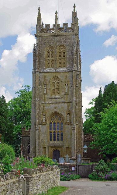
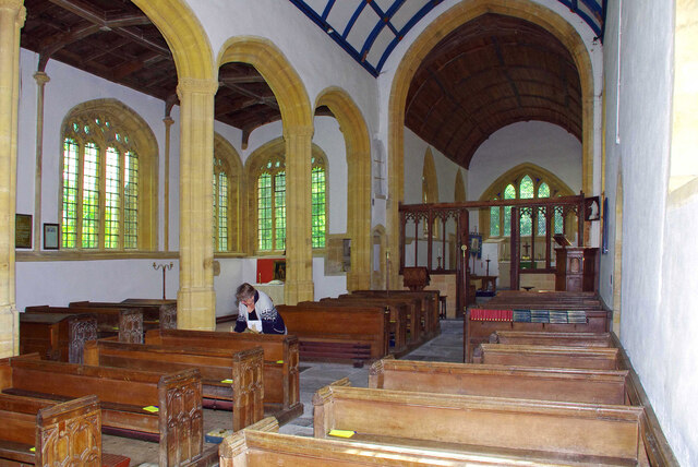
Church of St Mary the Virgin, Isle Abbotts

The Church of St Mary the Virgin in Isle Abbotts, Somerset, England dates from the 13th century with several restorations since. It has been designated...
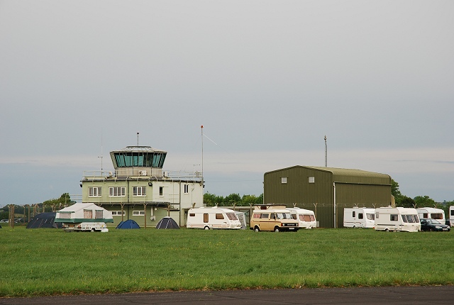
RNAS Merryfield

Royal Naval Air Station Merryfield, commonly known as RNAS Merryfield, is an air station of the Royal Navy's Fleet Air Arm located 2.7 miles (4 kilometres...
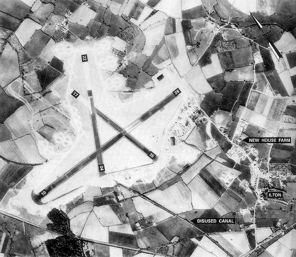
RAF Merryfield

Royal Air Force Merryfield or more simply RAF Merryfield (also known as Isle Abbotts) is a former Royal Air Force station in the village of Ilton near...

1945 Broadway Consolidated Liberator crash

The 1945 Broadway Consolidated Liberator crash occurred on 22 November 1945 when a Royal Air Force Consolidated Liberator C Mk VIII transport crashed shortly...

Church of St James, Curry Mallet

The Church of St James is a Church of England parish church in Curry Mallet, Somerset. It has 13th-century origins and has been designated as a Grade I...

Isle Brewers

Isle Brewers is a village and parish in Somerset, England, situated on the River Isle, 7 miles (11.3 km) south east of Taunton in the South Somerset district...

All Saints Church, Isle Brewers

All Saints Church is a Church of England parish church in Isle Brewers, Somerset, England. Designed by Charles Edmund Giles, it was built in 1859-61 and...

Related Videos

How to stop falling out with builders - How to become a property developer

George Bannister is the owner of BlackOak Ltd, Otterhead House & The Old Chicken House based nearTaunton, Somerset UK ...

How to find the perfect property - How to become a property developer

George Bannister is the owner of BlackOak Ltd, Otterhead House & The Old Chicken House based nearTaunton, Somerset UK ...

Losing motivation on a building project? - How to become a property developer

George Bannister is the owner of BlackOak Ltd, Otterhead House & The Old Chicken House based nearTaunton, Somerset UK ...

16 April 2022

Today's flying at Merryfield.

Nearby Amenities

Located within 500m of 50.97575,-2.9266151
The data included in this document is from www.openstreetmap.org. The data is made available under ODbL.

Have you been to Badbury?

Leave your review of Badbury below (or comments, questions and feedback).