Appletree

Settlement in Northamptonshire

England

Appletree

Narrowboat in Claydon Lock No. 19
Narrowboat in Claydon Lock No. 19 Credit: David Martin

Appletree is a small village located in Northamptonshire, England. Situated in the heart of the county, it is surrounded by picturesque countryside and offers a tranquil setting for residents and visitors alike.

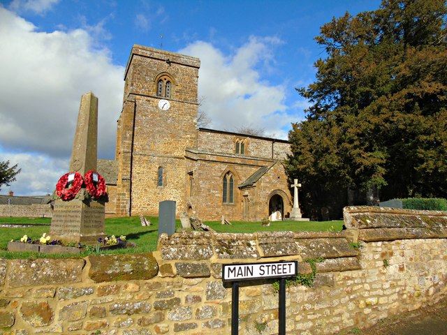
The village is characterized by its charming rural atmosphere, with traditional stone-built houses and well-maintained gardens. It has a close-knit community, where locals are known for their friendly and welcoming nature. Appletree is known for its strong sense of community spirit, with regular events and gatherings organized by residents throughout the year.

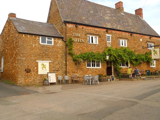
Despite its small size, Appletree boasts a range of amenities to cater to the needs of its residents. The village has a local pub, which serves as a popular meeting point for locals, as well as a village hall that hosts various social and recreational activities. Additionally, there is a primary school within the village, ensuring that families have access to quality education for their children.

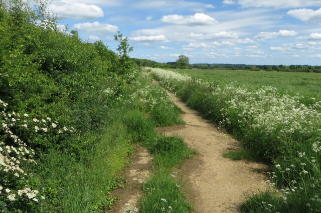
For those seeking outdoor activities, Appletree is surrounded by scenic walking and cycling routes, offering breathtaking views of the rolling countryside. The village is also within close proximity to other attractions in Northamptonshire, such as historic market towns, stately homes, and nature reserves, providing ample opportunities for exploration and leisure.

Overall, Appletree is a quintessential English village, offering a peaceful and idyllic lifestyle for its residents. With its strong sense of community, beautiful surroundings, and access to amenities, it is a place that many people are proud to call home.

If you have any feedback on the listing, please let us know in the comments section below.

Appletree Images

Images are sourced within 2km of 52.143369/-1.2937707 or Grid Reference SP4849. Thanks to Geograph Open Source API. All images are credited.

Narrowboat in Claydon Lock No. 19
Chipping Warden-The Griffin On Culworth Road.
Chipping Warden-The Griffin
On Culworth Road.
Footpath towards Calves Close Spinney
Manor House Cottages, Chipping Warden Date from the seventeenth century <span class="nowrap"><a title="https://historicengland.org.uk/listing/the-list/list-entry/1041203?section=official-list-entry" rel="nofollow ugc noopener" href="https://historicengland.org.uk/listing/the-list/list-entry/1041203?section=official-list-entry">Link</a><img style="margin-left:2px;" alt="External link" title="External link - shift click to open in new window" src="https://s1.geograph.org.uk/img/external.png" width="10" height="10"/></span>
Manor House Cottages, Chipping Warden
Date from the seventeenth century LinkExternal link
Old Direction Sign - Signpost in Aston le Walls, Northants No finial - 3 arms; Northants concrete by the UC road, in parish of Aston le Walls (South Northamptonshire District), Aston le Walls, junction of Appletree Lane with Main Street, behind stone wall next to farm gate.

To be surveyed

Milestone Society National ID: NR_SP4950
Old Direction Sign - Signpost in Aston le Walls, Northants
No finial - 3 arms; Northants concrete by the UC road, in parish of Aston le Walls (South Northamptonshire District), Aston le Walls, junction of Appletree Lane with Main Street, behind stone wall next to farm gate. To be surveyed Milestone Society National ID: NR_SP4950
Farmland, Aston le Walls A footpath through wheat to the north of the old Chipping Warden Airfield.
Farmland, Aston le Walls
A footpath through wheat to the north of the old Chipping Warden Airfield.
Farmland, Aston le Walls A crop of barley on flat land below the hill at Appletree.
Farmland, Aston le Walls
A crop of barley on flat land below the hill at Appletree.
Farmland, Aston le Walls A crop of wheat to the south of the former railway.
Farmland, Aston le Walls
A crop of wheat to the south of the former railway.
Farmland, Boddington Sheep grazing to the south of the road between Lower Boddington and Aston le Walls.
Farmland, Boddington
Sheep grazing to the south of the road between Lower Boddington and Aston le Walls.
Aston Le Walls Church
Oxford Canal - Claydon Lock No 19
Claydon Lock 18, Oxford Canal Looking over the top gate of the second from top lock of the flight of five at Claydon. The top lock is just around the bend. Note the plate on the gate which tells us that it was built in 2012 at the Canal and River Trust's Bradley Workshop.
Claydon Lock 18, Oxford Canal
Looking over the top gate of the second from top lock of the flight of five at Claydon. The top lock is just around the bend. Note the plate on the gate which tells us that it was built in 2012 at the Canal and River Trust's Bradley Workshop.
Oxford Canal Claydon Middle Lock on the Oxford Canal
Oxford Canal
Claydon Middle Lock on the Oxford Canal
Washbrook Farm, Aston-le-Walls equestrian centre: aerial See: <span class="nowrap"><a title="http://aston-le-walls.co.uk/" rel="nofollow ugc noopener" href="http://aston-le-walls.co.uk/">Link</a><img style="margin-left:2px;" alt="External link" title="External link - shift click to open in new window" src="https://s1.geograph.org.uk/img/external.png" width="10" height="10"/></span>
Looking north-west. 
This is a centre specialising in horse trials and the training of three-day-event horses.
This is a competition day: the horseboxes are parked in the field half way up on the right. The dressage arenas are opposite, extreme left.
The village top right is Lower Boddington.
The disused railway line across the bottom used to join up with the main line to Leamington Spa.
Washbrook Farm, Aston-le-Walls equestrian centre: aerial
See: LinkExternal link Looking north-west. This is a centre specialising in horse trials and the training of three-day-event horses. This is a competition day: the horseboxes are parked in the field half way up on the right. The dressage arenas are opposite, extreme left. The village top right is Lower Boddington. The disused railway line across the bottom used to join up with the main line to Leamington Spa.
Washbrook Farm, Aston-le-Walls equestrian centre: aerial See: <span class="nowrap"><a title="http://aston-le-walls.co.uk/" rel="nofollow ugc noopener" href="http://aston-le-walls.co.uk/">Link</a><img style="margin-left:2px;" alt="External link" title="External link - shift click to open in new window" src="https://s1.geograph.org.uk/img/external.png" width="10" height="10"/></span>
Looking north-east, with Boddington Reservoir in the distance. 
This is a centre specialising in horse trials and the training of three-day-event horses.
This is a competition day: the horseboxes are parked in the field top left. The white-edged oblongs in the foreground are the dressage.
The village top right is Lower Boddington.
The disused railway line running diagonally across the bottom used to join up with the main line to Leamington Spa.
Washbrook Farm, Aston-le-Walls equestrian centre: aerial
See: LinkExternal link Looking north-east, with Boddington Reservoir in the distance. This is a centre specialising in horse trials and the training of three-day-event horses. This is a competition day: the horseboxes are parked in the field top left. The white-edged oblongs in the foreground are the dressage. The village top right is Lower Boddington. The disused railway line running diagonally across the bottom used to join up with the main line to Leamington Spa.
Lower Boddington-Springfield Farm Entrance to the farm off the road to Claydon.
Lower Boddington-Springfield Farm
Entrance to the farm off the road to Claydon.
Bridge 145: Claydon Lock Bridge With a glimpse of Claydon Lock No 19 behind.
Bridge 145: Claydon Lock Bridge
With a glimpse of Claydon Lock No 19 behind.
Bridge 145 on the Southern Oxford Canal
Show me another place!

Appletree is located at Grid Ref: SP4849 (Lat: 52.143369, Lng: -1.2937707)

Unitary Authority: West Northamptonshire

Police Authority: Northamptonshire

What 3 Words

///waddle.socialite.former. Near Claydon, Oxfordshire

Nearby Locations

Appletree

Related Wikis

RAF Chipping Warden

Royal Air Force Chipping Warden or more simply RAF Chipping Warden was a Royal Air Force station located 6 miles (10 km) north-east of Banbury near the...

Prescote

Prescote is a hamlet and civil parish about 4 miles (6.4 km) north of Banbury in Oxfordshire. Its boundaries are the River Cherwell in the southeast, a...

Chipping Warden

Chipping Warden is a village and former civil parish, now in the parish of Chipping Warden and Edgcote, in the West Northamptonshire district, in the ceremonial...

Aston le Walls

Aston le Walls is a village and civil parish in West Northamptonshire, England, close by the border with Oxfordshire. The village is about 9 miles (14...

Related Videos

Overland Event Winter Warmer 2020

The Overland Event Winter Warmer, in association with Exotogg, returned to Chipping Warden from 7th to 9th February 2020 for ...

Table Thai Massage

A new service from Mindful Touch Massage.

Nearby Amenities

Located within 500m of 52.143369,-1.2937707
Power: pole
Lat/Long: 52.1430775/-1.2934586
Power: pole
Lat/Long: 52.1434997/-1.2938193
Power: pole
Lat/Long: 52.142991/-1.292751
Power: pole
Lat/Long: 52.1433129/-1.2894729
Power: pole
Lat/Long: 52.1440714/-1.2951106
Power: pole
Lat/Long: 52.142795/-1.2910746
Power: pole
Lat/Long: 52.1430161/-1.2978355
Power: pole
Lat/Long: 52.1435691/-1.2964792
Power: pole
Lat/Long: 52.1428962/-1.2919283
Power: pole
Lat/Long: 52.1429949/-1.2899657
Power: pole
Lat/Long: 52.1442756/-1.2940774
Power: pole
Lat/Long: 52.1427244/-1.2904374
Power: pole
Lat/Long: 52.140667/-1.2981525
Power: pole
Lat/Long: 52.1426116/-1.2969832
Power: pole
Lat/Long: 52.1410979/-1.2977279
Power: pole
Lat/Long: 52.1415246/-1.2973075
Power: pole
Lat/Long: 52.1402123/-1.2986098
Power: pole
Lat/Long: 52.1428495/-1.2975091
Power: pole
Lat/Long: 52.141937/-1.2968953
Power: pole
Lat/Long: 52.1423738/-1.2964734
Grit Bin
Source: survey
Lat/Long: 52.1434488/-1.2936577
Barrier: stile
Source: survey
Lat/Long: 52.1412861/-1.2890644
Place: farm
Lat/Long: 52.1433521/-1.2899711
Place: farm
Lat/Long: 52.1428122/-1.2983611
The data included in this document is from www.openstreetmap.org. The data is made available under ODbL.

Have you been to Appletree?

Leave your review of Appletree below (or comments, questions and feedback).