Brown Jewel

Island in Kincardineshire

Scotland

Brown Jewel

Fields and houses at Muchalls
Fields and houses at Muchalls Credit: Mike Pennington

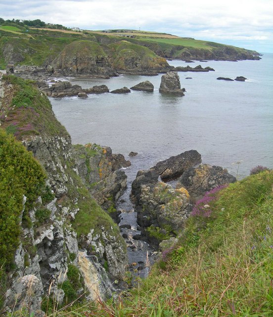
Brown Jewel is a small island located off the coast of Kincardineshire, in northeastern Scotland. Situated in the North Sea, the island is part of the Aberdeenshire council area. With a total land area of approximately 15 acres, Brown Jewel is characterized by its rugged and rocky terrain, surrounded by cliffs and small sandy beaches.

The island derives its name from the distinctive brown color of its rocks, which are composed mainly of granite and sandstone. Its unique geological formation makes it an interesting destination for geologists and rock enthusiasts. The island is also home to a variety of flora and fauna, including seabirds, seals, and occasional sightings of dolphins and whales.

Access to Brown Jewel is possible by private boat or ferry from the nearby mainland. While there are no permanent residents on the island, it has historical significance as it was once inhabited by a small fishing community. The remains of old stone houses and fishing huts can still be seen, offering glimpses into the island's past.

Visitors to Brown Jewel can enjoy scenic walks along the coastal paths, taking in the stunning views of the surrounding sea and cliffs. The island provides a peaceful retreat for nature lovers and those seeking solitude. However, it is important to note that there are no facilities or accommodations available on the island, so visitors must bring their own supplies and be mindful of the fragile ecosystem.

Overall, Brown Jewel offers a unique and picturesque experience for those looking to explore a remote and untamed Scottish island.

If you have any feedback on the listing, please let us know in the comments section below.

Brown Jewel Images

Images are sourced within 2km of 57.020858/-2.1530562 or Grid Reference NO9092. Thanks to Geograph Open Source API. All images are credited.

Fields and houses at Muchalls
Rocks at Grim Haven
Rocks at Grim Haven
Cliff girt coast at Muchalls
Windyedge, Newtonhill
Site of Newtonhill Station The station closed in 1956 although there is some talk of reopening it as Newtonhill has transformed from a fishing village to a commuter settlement.  Compare the photo from 2009 <a title="https://www.geograph.org.uk/photo/1454732" href="https://www.geograph.org.uk/photo/1454732">Link</a> for changes to track layout and signals.
Site of Newtonhill Station
The station closed in 1956 although there is some talk of reopening it as Newtonhill has transformed from a fishing village to a commuter settlement. Compare the photo from 2009 Link for changes to track layout and signals.
High Speed Train The 14:52 from Aberdeen to King's Cross passes the site of Newtonhill station.
High Speed Train
The 14:52 from Aberdeen to King's Cross passes the site of Newtonhill station.
Newtonhill parish church This modest structure dates from 1987.
Newtonhill parish church
This modest structure dates from 1987.
Newtonhill: walking to the harbour The cat was friendly...
Newtonhill: walking to the harbour
The cat was friendly...
Newtonhill Bay
Newtonhill Bay
Walking the coastal path The rugged Cran Hill (elev. 86 m) is in the background: could it be called a tor?
Walking the coastal path
The rugged Cran Hill (elev. 86 m) is in the background: could it be called a tor?
The Newton Arms, Newtonhill
A92, Nether Mains of Muchalls The A92 is a major highway that runs for 89 miles through Fife, Dundee, Angus, Aberdeenshire, and Aberdeen City in Scotland. From south to north, it runs from Dunfermline to Blackdog, just north of Aberdeen.
A92, Nether Mains of Muchalls
The A92 is a major highway that runs for 89 miles through Fife, Dundee, Angus, Aberdeenshire, and Aberdeen City in Scotland. From south to north, it runs from Dunfermline to Blackdog, just north of Aberdeen.
Northbound A92 at Muchalls The A92 is a major highway that runs for 89 miles through Fife, Dundee, Angus, Aberdeenshire, and Aberdeen City in Scotland. From south to north, it runs from Dunfermline to Blackdog, just north of Aberdeen.
Northbound A92 at Muchalls
The A92 is a major highway that runs for 89 miles through Fife, Dundee, Angus, Aberdeenshire, and Aberdeen City in Scotland. From south to north, it runs from Dunfermline to Blackdog, just north of Aberdeen.
Houses at Newtonhill Viewed from the A92.
Houses at Newtonhill
Viewed from the A92.
Plaxton Elite Coach on the A92 at Newtonhill Park's of Hamilton Volvo B11R/Plaxton Elite (LSK 873) heading south on the A92 at Newtonhill.
Plaxton Elite Coach on the A92 at Newtonhill
Park's of Hamilton Volvo B11R/Plaxton Elite (LSK 873) heading south on the A92 at Newtonhill.
Bridge over the A92 at Newtonhill The A92 is a major highway that runs for 89 miles through Fife, Dundee, Angus, Aberdeenshire, and Aberdeen City in Scotland. From south to north, it runs from Dunfermline to Blackdog, just north of Aberdeen.
Bridge over the A92 at Newtonhill
The A92 is a major highway that runs for 89 miles through Fife, Dundee, Angus, Aberdeenshire, and Aberdeen City in Scotland. From south to north, it runs from Dunfermline to Blackdog, just north of Aberdeen.
View from Doonies Point In the foreground are some of the flat-lying rocks north of a zone of intense deformation known as the Steep Belt. Compare this with <a href="https://www.geograph.org.uk/photo/6279535">NO9090 : Folded Rock</a>.
View from Doonies Point
In the foreground are some of the flat-lying rocks north of a zone of intense deformation known as the Steep Belt. Compare this with NO9090 : Folded Rock.
Cliffs at Muchalls A rather misty view north from Doonies Point, where another step, to get into the square, would have sent me hurtling down the cliff!
Cliffs at Muchalls
A rather misty view north from Doonies Point, where another step, to get into the square, would have sent me hurtling down the cliff!
Show me another place!

Brown Jewel is located at Grid Ref: NO9092 (Lat: 57.020858, Lng: -2.1530562)

Unitary Authority: Aberdeenshire

Police Authority: North East

What 3 Words

///numeral.hunter.thorax. Near Newtonhill, Aberdeenshire

Related Wikis

Brown Jewel

The Brown Jewel is a sea stack on the North Sea coast of Scotland, north of the village of Muchalls in Aberdeenshire. == History == Brown Jewel is situated...

Burn of Pheppie

The Burn of Pheppie is an easterly flowing coastal stream in Aberdeenshire, Scotland that discharges to the North Sea immediately north of the village...
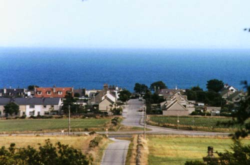
Muchalls

Muchalls is a small coastal ex-fishing village in Kincardineshire, Scotland, south of Newtonhill and north of Stonehaven. Muchalls is situated slightly...

May Craig (island)

May Craig is a rocky island situated along the North Sea coast of Aberdeenshire, Scotland. May Craig lies about one half mile (0.8 km) south of Newtonhill...

Grim Brigs

Grim Brigs (Grid reference NO9091) is a rocky headland on the North Sea at Muchalls, Scotland. Notable historic features in this vicinity include St....

Muchalls railway station

Muchalls railway station served the village of Muchalls, Kincardineshire, Scotland from 1849 to 1950 on the Aberdeen Railway. == History == The station...

Burn of Muchalls

The Burn of Muchalls is an easterly flowing stream in Aberdeenshire, Scotland that discharges to the North Sea. Its point of discharge is on a rocky beach...

Burn of Monboys

Burn of Monboys is a stream that rises in the Mounth, or eastern range of the Grampian Mountains, northwest of Stonehaven and south of Netherley, Aberdeenshire...

Nearby Amenities

Located within 500m of 57.020858,-2.1530562
Source: PGS
Lat/Long: 57.018644/-2.159484
Source: PGS
Lat/Long: 57.0192114/-2.1592112
Source: PGS
Lat/Long: 57.0192354/-2.1590711
Source: PGS
Lat/Long: 57.0191188/-2.1589842
Source: PGS
Lat/Long: 57.0187702/-2.1584567
Source: PGS
Lat/Long: 57.0190248/-2.1586418
Source: PGS
Lat/Long: 57.0194616/-2.1581469
Source: PGS
Lat/Long: 57.0199175/-2.156845
Source: PGS
Lat/Long: 57.020033/-2.156636
Source: PGS
Lat/Long: 57.020198/-2.1559571
Source: PGS
Lat/Long: 57.0200249/-2.1551004
Source: PGS
Lat/Long: 57.02015/-2.154991
Source: PGS
Lat/Long: 57.0204089/-2.1551031
Source: PGS
Lat/Long: 57.020664/-2.155213
Source: PGS
Lat/Long: 57.020779/-2.153333
Source: PGS
Lat/Long: 57.020905/-2.153096
Source: PGS
Lat/Long: 57.021403/-2.152234
Source: PGS
Lat/Long: 57.021925/-2.152368
Source: PGS
Lat/Long: 57.021918/-2.151429
Source: PGS
Lat/Long: 57.0223977/-2.1512711
Source: PGS
Lat/Long: 57.022548/-2.150007
Source: PGS
Lat/Long: 57.022798/-2.149062
Source: PGS
Lat/Long: 57.022925/-2.148825
Source: PGS
Lat/Long: 57.023051/-2.148587
Source: PGS
Lat/Long: 57.023178/-2.14835
Source: PGS
Lat/Long: 57.023506/-2.1484229
Source: PGS
Lat/Long: 57.0234833/-2.1479288
Source: PGS
Lat/Long: 57.0236924/-2.1477405
Source: PGS
Lat/Long: 57.0242128/-2.1479462
Power: pole
Lat/Long: 57.0246643/-2.1571945
Power: pole
Lat/Long: 57.0245073/-2.15645
The data included in this document is from www.openstreetmap.org. The data is made available under ODbL.

Have you been to Brown Jewel?

Leave your review of Brown Jewel below (or comments, questions and feedback).