Black Rocks

Island in Midlothian

Scotland

Black Rocks

Tenements, Leith Thorntree Street off Easter Road. A Leith street scene.
Tenements, Leith Credit: Richard Webb

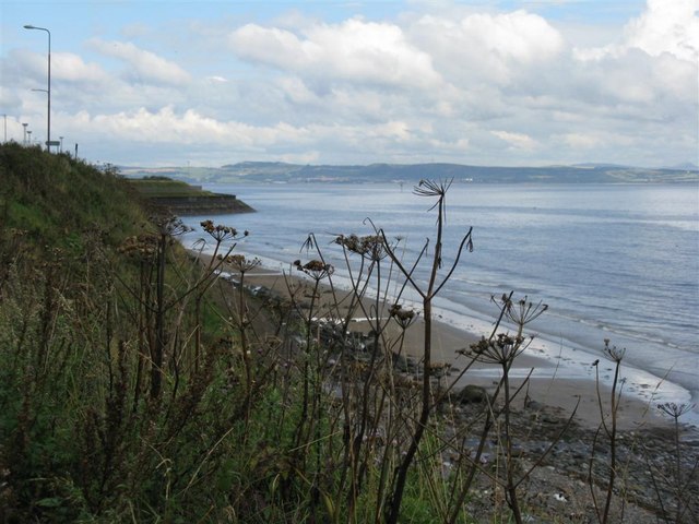
Black Rocks is a small island located off the coast of Midlothian, Scotland. Situated in the Firth of Forth, it lies approximately 6 miles east of the capital city, Edinburgh. The island is known for its distinctive black volcanic rocks, which give it its name.

Covering an area of around 1.2 hectares, Black Rocks is a rocky outcrop that rises about 20 meters above sea level. It is predominantly made up of basalt, a type of volcanic rock formed from solidified lava. The dark color of the rocks is a result of their high iron content.

The island is uninhabited and is primarily used as a nesting site for various bird species. It is particularly known for being a breeding ground for herring gulls and eider ducks. Due to its remote location and lack of human disturbance, it provides a safe haven for these birds to raise their young.

Access to Black Rocks is limited, and visitors are not permitted to land on the island to protect the fragile ecosystem. However, it can be admired from a distance by boat or from nearby coastal areas such as Musselburgh or Fisherrow. The island's unique geological features and rich birdlife make it an interesting and important site for nature enthusiasts and birdwatchers.

Overall, Black Rocks is a small but significant island off the coast of Midlothian, known for its striking black volcanic rocks and its importance as a breeding ground for various bird species.

If you have any feedback on the listing, please let us know in the comments section below.

Black Rocks Images

Images are sourced within 2km of 55.980304/-3.1479755 or Grid Reference NT2876. Thanks to Geograph Open Source API. All images are credited.

Tenements, Leith Thorntree Street off Easter Road. A Leith street scene.
Tenements, Leith
Thorntree Street off Easter Road. A Leith street scene.
Parking at Leith On the redeveloped waterfront at Leith Harbour.
Parking at Leith
On the redeveloped waterfront at Leith Harbour.
Street sculpture, Leith Urban regeneration by Leith Docks.
Street sculpture, Leith
Urban regeneration by Leith Docks.
Scottish Executive offices New civil service offices in Leith, part of the docks redevelopment.
Scottish Executive offices
New civil service offices in Leith, part of the docks redevelopment.
Builder's Merchant, Salamander Street An area of warehouses and tin shed shops. Beyond this yard, deeper into the square, is an area by the docks that was once  a railway marshalling yard.
Builder's Merchant, Salamander Street
An area of warehouses and tin shed shops. Beyond this yard, deeper into the square, is an area by the docks that was once a railway marshalling yard.
Seafield. Sea defences at Seafield. The bulge in the coastline is an area that has been reclaimed from the sea. The photo was taken at the end of a beach that stretches 3km south east to Joppa.
Seafield.
Sea defences at Seafield. The bulge in the coastline is an area that has been reclaimed from the sea. The photo was taken at the end of a beach that stretches 3km south east to Joppa.
House repairs, Craigentinny Craigentinny Avenue, a private road beside a municipal golf course in an otherwise industrial area.
House repairs, Craigentinny
Craigentinny Avenue, a private road beside a municipal golf course in an otherwise industrial area.
Digesters. Part of the sewerage treatment for Edinburgh, built on reclaimed land in Seafield.  The towers provide a site for anaerobic bacteria to digest waste and produce methane. The methane is stored in the sinister looking white sphere at the end and used to produce electricity and heat for the Seafield complex.
Digesters.
Part of the sewerage treatment for Edinburgh, built on reclaimed land in Seafield. The towers provide a site for anaerobic bacteria to digest waste and produce methane. The methane is stored in the sinister looking white sphere at the end and used to produce electricity and heat for the Seafield complex.
Fuel depot, Leith Docks. Taken from the shore, on a long walk to get at the inaccessible squares of Leith.  Fuel, oil for heating was being taken from these tanks by lorry.  I expect some of this complex supplies fuel oil for shipping - it is probably a store for some of the longer chained hydrocarbons.
Fuel depot, Leith Docks.
Taken from the shore, on a long walk to get at the inaccessible squares of Leith. Fuel, oil for heating was being taken from these tanks by lorry. I expect some of this complex supplies fuel oil for shipping - it is probably a store for some of the longer chained hydrocarbons.
Coastal defences, Leith. The current docklands around Leith contain a lot of reclaimed land. The sea is repelled by all maner of builders rubble. Bricks, reinforced concrete etc. View over to Inchkeith.
Coastal defences, Leith.
The current docklands around Leith contain a lot of reclaimed land. The sea is repelled by all maner of builders rubble. Bricks, reinforced concrete etc. View over to Inchkeith.
Tally Too'er, Leith One of Scotland's three Martello Towers, Napoleonic era defences. This was an offshore fort, but now is buried in an industrial area on reclaimed land, surrounded by pipes. However the area is due yet more change. Currently far from the public eye, I walked miles along the shore to get here, and was surprised not to be stopped, this area is due to be developed for housing. A bridge will link it to the developments currently being built west of the docks entrance.

2019
The development never happened. The company behind it went under when the banks collapsed in 2008.
Tally Too'er, Leith
One of Scotland's three Martello Towers, Napoleonic era defences. This was an offshore fort, but now is buried in an industrial area on reclaimed land, surrounded by pipes. However the area is due yet more change. Currently far from the public eye, I walked miles along the shore to get here, and was surprised not to be stopped, this area is due to be developed for housing. A bridge will link it to the developments currently being built west of the docks entrance. 2019 The development never happened. The company behind it went under when the banks collapsed in 2008.
Knee deep in the Big Muddy Except for exceptional spring lows when the pipeline pops out, the navigation beacon at the end of an outfall pipe is all of this square visible above the sea. The OS suggest that a fragment of beach exists at low tide at NT290760. I visited the corner nearest land at the  lowest tide of the month and was still knee deep in the murky Firth of Forth.   Quite a bit of wading was required.
Knee deep in the Big Muddy
Except for exceptional spring lows when the pipeline pops out, the navigation beacon at the end of an outfall pipe is all of this square visible above the sea. The OS suggest that a fragment of beach exists at low tide at NT290760. I visited the corner nearest land at the lowest tide of the month and was still knee deep in the murky Firth of Forth. Quite a bit of wading was required.
Eastern Craigs. Visited just after a spring low water and was able to get to these offshore rocks which are flooded at high tide. Lots of rockpools and mussel beds (Being the "Shiney Bright", not fit for human consumption)
Eastern Craigs.
Visited just after a spring low water and was able to get to these offshore rocks which are flooded at high tide. Lots of rockpools and mussel beds (Being the "Shiney Bright", not fit for human consumption)
Mussel beds, Eastern Craigs. Being a spring tide, a rare exposure for some of these molluscs.  Visited at a spring low.
Mussel beds, Eastern Craigs.
Being a spring tide, a rare exposure for some of these molluscs. Visited at a spring low.
Ocean Mist, Leith 1918 built steam yacht "Ocean Mist". Being converted to a restaurant/conference centre in November 2005. The engine is still in situ.
The first geograph for this square is on the other side against her bow.
Ocean Mist, Leith
1918 built steam yacht "Ocean Mist". Being converted to a restaurant/conference centre in November 2005. The engine is still in situ. The first geograph for this square is on the other side against her bow.
Colourful machinery, Leith Docks Not too sure what it's all for - pipe laying possibly.  Viewed from the Ocean Terminal shopping centre car park.  Looking north.
Colourful machinery, Leith Docks
Not too sure what it's all for - pipe laying possibly. Viewed from the Ocean Terminal shopping centre car park. Looking north.
Ocean Terminal, Leith. Leith has been undergoing a transformation in recent years and is now the scene of many new flats, shops, etc centred around the docks and the Water of Leith. Ocean Terminal is a huge shopping complex - and the former Royal yacht, Britannia, is moored here.
Ocean Terminal, Leith.
Leith has been undergoing a transformation in recent years and is now the scene of many new flats, shops, etc centred around the docks and the Water of Leith. Ocean Terminal is a huge shopping complex - and the former Royal yacht, Britannia, is moored here.
The Cow's Pyjamas One of the 94 cows in the 2006 Edinburgh Cow Parade. This one, The Cow's Pyjamas, is located in front of its sponsor, Malmasion Hotel in Leith. The artists are Justin Ryan and Colin McAllister.
The Cow's Pyjamas
One of the 94 cows in the 2006 Edinburgh Cow Parade. This one, The Cow's Pyjamas, is located in front of its sponsor, Malmasion Hotel in Leith. The artists are Justin Ryan and Colin McAllister.
Show me another place!

Black Rocks is located at Grid Ref: NT2876 (Lat: 55.980304, Lng: -3.1479755)

Unitary Authority: City of Edinburgh

Police Authority: Edinburgh

What 3 Words

///drive.salsa.bonus. Near Edinburgh

Related Wikis

SS Explorer

SS Explorer is one of the last surviving sea-going steam trawlers and is registered to Leith, the port of Edinburgh. She has been placed on the National...

South Leith railway station

South Leith railway station served the area of Leith, Edinburgh, Scotland from 1832 to 1903 on the Edinburgh and Dalkeith Railway. == History == The station...

Corn Exchange, Leith

The Corn Exchange is a commercial building in Constitution Street, Leith, Scotland. The structure, which accommodates studio space and an exhibition gallery...

Seafield, Edinburgh

Seafield is a coastal strip situated on the Firth of Forth between Leith and Portobello in north-east Edinburgh, Scotland. The area is mainly commercial...

Nearby Amenities

Located within 500m of 55.980304,-3.1479755
Man Made: beacon
Lat/Long: 55.9788602/-3.1449573
Seamark Name: St Anthony's Bush
Seamark Rock Water Level: covers
Seamark Type: rock
Lat/Long: 55.9821409/-3.1455362
Man Made: chimney
Lat/Long: 55.9781475/-3.1549484
The data included in this document is from www.openstreetmap.org. The data is made available under ODbL.

Have you been to Black Rocks?

Leave your review of Black Rocks below (or comments, questions and feedback).