East Sands of Leith

Beach in Midlothian

Scotland

East Sands of Leith

Tenements, Leith Thorntree Street off Easter Road. A Leith street scene.
Tenements, Leith Credit: Richard Webb

Located on the eastern coast of Scotland, the East Sands of Leith is a picturesque beach in the county of Midlothian. Situated just a few miles from the bustling city of Edinburgh, it offers locals and tourists alike a tranquil escape from the urban environment.

Stretching over a mile long, the beach boasts soft golden sands that are perfect for sunbathing, picnicking, and leisurely strolls. The calm and shallow waters provide a safe and enjoyable swimming experience, particularly for families with young children. Lifeguards are stationed during peak seasons to ensure the safety of visitors.

East Sands of Leith is known for its stunning views of the Firth of Forth, with its clear waters and distant views of the iconic Forth Rail Bridge. The beach also offers a picturesque backdrop of the surrounding rolling hills, providing a serene setting for visitors to relax and unwind.

Facilities at the beach include public toilets, ample parking space, and a nearby café where visitors can grab a bite to eat or enjoy a refreshing beverage. The beach is easily accessible by car or public transport, and there are several walking and cycling paths that lead to the area.

For those seeking more adventurous activities, East Sands of Leith is a popular spot for water sports such as kayaking and paddleboarding. The beach is also a prime location for bird watching, with a variety of seabirds frequently spotted along the coast.

Overall, the East Sands of Leith in Midlothian offers a delightful combination of natural beauty, recreational activities, and stunning vistas, making it a must-visit destination for beach lovers and nature enthusiasts alike.

If you have any feedback on the listing, please let us know in the comments section below.

East Sands of Leith Images

Images are sourced within 2km of 55.977508/-3.1510497 or Grid Reference NT2876. Thanks to Geograph Open Source API. All images are credited.

Tenements, Leith Thorntree Street off Easter Road. A Leith street scene.
Tenements, Leith
Thorntree Street off Easter Road. A Leith street scene.
Parking at Leith On the redeveloped waterfront at Leith Harbour.
Parking at Leith
On the redeveloped waterfront at Leith Harbour.
Street sculpture, Leith Urban regeneration by Leith Docks.
Street sculpture, Leith
Urban regeneration by Leith Docks.
Port of Leith Taken in the Port of Leith, this shows the Fisheries Protection Vessel MV Minna.
Port of Leith
Taken in the Port of Leith, this shows the Fisheries Protection Vessel MV Minna.
Mills, Port of Leith
Scottish Executive offices New civil service offices in Leith, part of the docks redevelopment.
Scottish Executive offices
New civil service offices in Leith, part of the docks redevelopment.
Builder's Merchant, Salamander Street An area of warehouses and tin shed shops. Beyond this yard, deeper into the square, is an area by the docks that was once  a railway marshalling yard.
Builder's Merchant, Salamander Street
An area of warehouses and tin shed shops. Beyond this yard, deeper into the square, is an area by the docks that was once a railway marshalling yard.
Seafield. Sea defences at Seafield. The bulge in the coastline is an area that has been reclaimed from the sea. The photo was taken at the end of a beach that stretches 3km south east to Joppa.
Seafield.
Sea defences at Seafield. The bulge in the coastline is an area that has been reclaimed from the sea. The photo was taken at the end of a beach that stretches 3km south east to Joppa.
House repairs, Craigentinny Craigentinny Avenue, a private road beside a municipal golf course in an otherwise industrial area.
House repairs, Craigentinny
Craigentinny Avenue, a private road beside a municipal golf course in an otherwise industrial area.
Ship's Bell, H.M. Yacht Britannia
H.M. Yacht Britannia
Digesters. Part of the sewerage treatment for Edinburgh, built on reclaimed land in Seafield.  The towers provide a site for anaerobic bacteria to digest waste and produce methane. The methane is stored in the sinister looking white sphere at the end and used to produce electricity and heat for the Seafield complex.
Digesters.
Part of the sewerage treatment for Edinburgh, built on reclaimed land in Seafield. The towers provide a site for anaerobic bacteria to digest waste and produce methane. The methane is stored in the sinister looking white sphere at the end and used to produce electricity and heat for the Seafield complex.
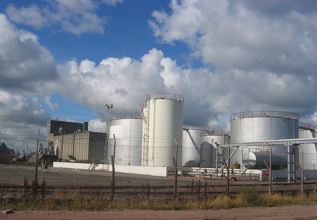
Fuel depot, Leith Docks. Taken from the shore, on a long walk to get at the inaccessible squares of Leith.  Fuel, oil for heating was being taken from these tanks by lorry.  I expect some of this complex supplies fuel oil for shipping - it is probably a store for some of the longer chained hydrocarbons.
Fuel depot, Leith Docks.
Taken from the shore, on a long walk to get at the inaccessible squares of Leith. Fuel, oil for heating was being taken from these tanks by lorry. I expect some of this complex supplies fuel oil for shipping - it is probably a store for some of the longer chained hydrocarbons.
Coastal defences, Leith. The current docklands around Leith contain a lot of reclaimed land. The sea is repelled by all maner of builders rubble. Bricks, reinforced concrete etc. View over to Inchkeith.
Coastal defences, Leith.
The current docklands around Leith contain a lot of reclaimed land. The sea is repelled by all maner of builders rubble. Bricks, reinforced concrete etc. View over to Inchkeith.
Tally Too'er, Leith One of Scotland's three Martello Towers, Napoleonic era defences. This was an offshore fort, but now is buried in an industrial area on reclaimed land, surrounded by pipes. However the area is due yet more change. Currently far from the public eye, I walked miles along the shore to get here, and was surprised not to be stopped, this area is due to be developed for housing. A bridge will link it to the developments currently being built west of the docks entrance.

2019
The development never happened. The company behind it went under when the banks collapsed in 2008.
Tally Too'er, Leith
One of Scotland's three Martello Towers, Napoleonic era defences. This was an offshore fort, but now is buried in an industrial area on reclaimed land, surrounded by pipes. However the area is due yet more change. Currently far from the public eye, I walked miles along the shore to get here, and was surprised not to be stopped, this area is due to be developed for housing. A bridge will link it to the developments currently being built west of the docks entrance. 2019 The development never happened. The company behind it went under when the banks collapsed in 2008.
Knee deep in the Big Muddy Except for exceptional spring lows when the pipeline pops out, the navigation beacon at the end of an outfall pipe is all of this square visible above the sea. The OS suggest that a fragment of beach exists at low tide at NT290760. I visited the corner nearest land at the  lowest tide of the month and was still knee deep in the murky Firth of Forth.   Quite a bit of wading was required.
Knee deep in the Big Muddy
Except for exceptional spring lows when the pipeline pops out, the navigation beacon at the end of an outfall pipe is all of this square visible above the sea. The OS suggest that a fragment of beach exists at low tide at NT290760. I visited the corner nearest land at the lowest tide of the month and was still knee deep in the murky Firth of Forth. Quite a bit of wading was required.
Eastern Craigs. Visited just after a spring low water and was able to get to these offshore rocks which are flooded at high tide. Lots of rockpools and mussel beds (Being the "Shiney Bright", not fit for human consumption)
Eastern Craigs.
Visited just after a spring low water and was able to get to these offshore rocks which are flooded at high tide. Lots of rockpools and mussel beds (Being the "Shiney Bright", not fit for human consumption)
Mussel beds, Eastern Craigs. Being a spring tide, a rare exposure for some of these molluscs.  Visited at a spring low.
Mussel beds, Eastern Craigs.
Being a spring tide, a rare exposure for some of these molluscs. Visited at a spring low.
Show me another place!

East Sands of Leith is located at Grid Ref: NT2876 (Lat: 55.977508, Lng: -3.1510497)

Unitary Authority: City of Edinburgh

Police Authority: Edinburgh

What 3 Words

///tell.factories.drag. Near Edinburgh

Related Wikis

SS Explorer

SS Explorer is one of the last surviving sea-going steam trawlers and is registered to Leith, the port of Edinburgh. She has been placed on the National...

South Leith railway station

South Leith railway station served the area of Leith, Edinburgh, Scotland from 1832 to 1903 on the Edinburgh and Dalkeith Railway. == History == The station...

Corn Exchange, Leith

The Corn Exchange is a commercial building in Constitution Street, Leith, Scotland. The structure, which accommodates studio space and an exhibition gallery...

LGBT Youth Scotland

LGBT Youth Scotland is a Scottish youth organisation dedicated to the inclusion of lesbian, gay, bisexual and transgender (LGBT) young people from 13 to...

Nearby Amenities

Located within 500m of 55.977508,-3.1510497
Railway: level_crossing
Lat/Long: 55.9738315/-3.1510563
Crossing
Crossing: uncontrolled
Lat/Long: 55.9766036/-3.1585348
Barrier: lift_gate
Bicycle: yes
Foot: yes
Motorcar: yes
Motorcycle: yes
Lat/Long: 55.9762721/-3.1536707
Railway: switch
Lat/Long: 55.9736087/-3.1543093
Stop
Direction: forward
Lat/Long: 55.976137/-3.1534279
Man Made: beacon
Lat/Long: 55.9788602/-3.1449573
Railway: switch
Lat/Long: 55.9770331/-3.1545741
Barrier: bollard
Bicycle: yes
Foot: yes
Lat/Long: 55.9749044/-3.1479058
Railway: switch
Lat/Long: 55.9746707/-3.1522851
Railway: level_crossing
Lat/Long: 55.9739049/-3.1509707
Railway: switch
Lat/Long: 55.9748913/-3.1528591
Albert Road Level Crossing
Railway: level_crossing
Source: Bing;survey
Lat/Long: 55.9757135/-3.1537904
Railway: level_crossing
Source: Bing;survey
Lat/Long: 55.9761294/-3.153973
Railway: level_crossing
Lat/Long: 55.976556/-3.1541454
Railway: switch
Lat/Long: 55.9733897/-3.1538755
Railway: level_crossing
Lat/Long: 55.9737792/-3.1511174
Noexit: yes
Lat/Long: 55.9738481/-3.1553393
Noexit: yes
Lat/Long: 55.9738864/-3.155297
Railway: level_crossing
Lat/Long: 55.9738754/-3.1510051
Railway: level_crossing
Lat/Long: 55.9739368/-3.1509334
Railway: switch
Lat/Long: 55.9745155/-3.1519381
Railway: switch
Lat/Long: 55.9745648/-3.152313
Barrier: lift_gate
Bicycle: yes
Foot: yes
Motorcar: yes
Motorcycle: yes
Lat/Long: 55.976019/-3.1530867
Addr City: Edinburgh
Addr Housenumber: 25
Addr Street: Albert Road
Lat/Long: 55.9752559/-3.1550915
Addr City: Edinburgh
Addr Housenumber: 23
Addr Street: Albert Road
Lat/Long: 55.9749254/-3.1554655
Tower Productions
Office: company
Lat/Long: 55.9749896/-3.1556292
Survitec
Office: company
Lat/Long: 55.9745872/-3.1560867
The Roe Group
Office: company
Lat/Long: 55.9753849/-3.1533455
Barrier: block
Lat/Long: 55.9742833/-3.1553977
Barrier: gap
Maxwidth: 1
Lat/Long: 55.9749929/-3.1481114
Man Made: chimney
Lat/Long: 55.9781475/-3.1549484
Barrier: lift_gate
Lat/Long: 55.9761438/-3.1538594
Barrier: lift_gate
Lat/Long: 55.9756572/-3.1538533
Barrier: lift_gate
Lat/Long: 55.9757474/-3.1537504
Stop
Direction: forward
Lat/Long: 55.9759851/-3.153483
Barrier: lift_gate
Lat/Long: 55.9761242/-3.1541166
Railway: switch
Lat/Long: 55.9737881/-3.1554485
Railway: level_crossing
Lat/Long: 55.9784327/-3.1579595
The data included in this document is from www.openstreetmap.org. The data is made available under ODbL.

Have you been to East Sands of Leith?

Leave your review of East Sands of Leith below (or comments, questions and feedback).