Cow and Calves

Island in Midlothian

Scotland

Cow and Calves

Inchmickery Island Partly demolished wartime jetty, fortifications and military buildings on island in the Firth of Forth
Inchmickery Island Credit: James Allan

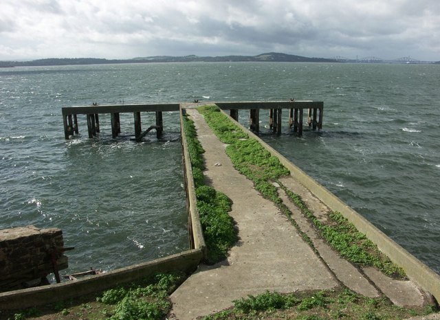
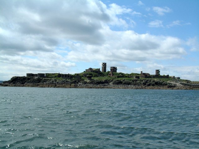
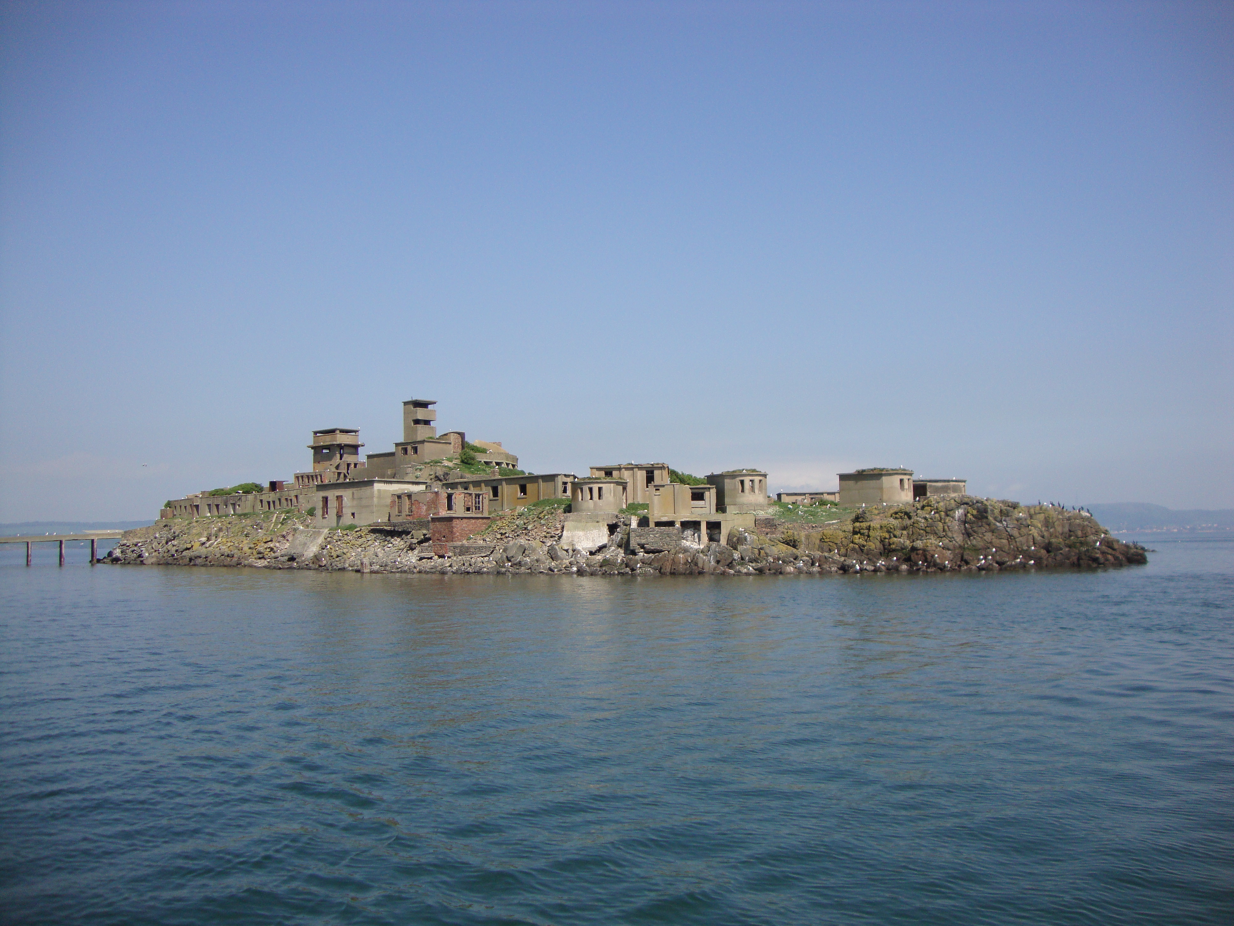
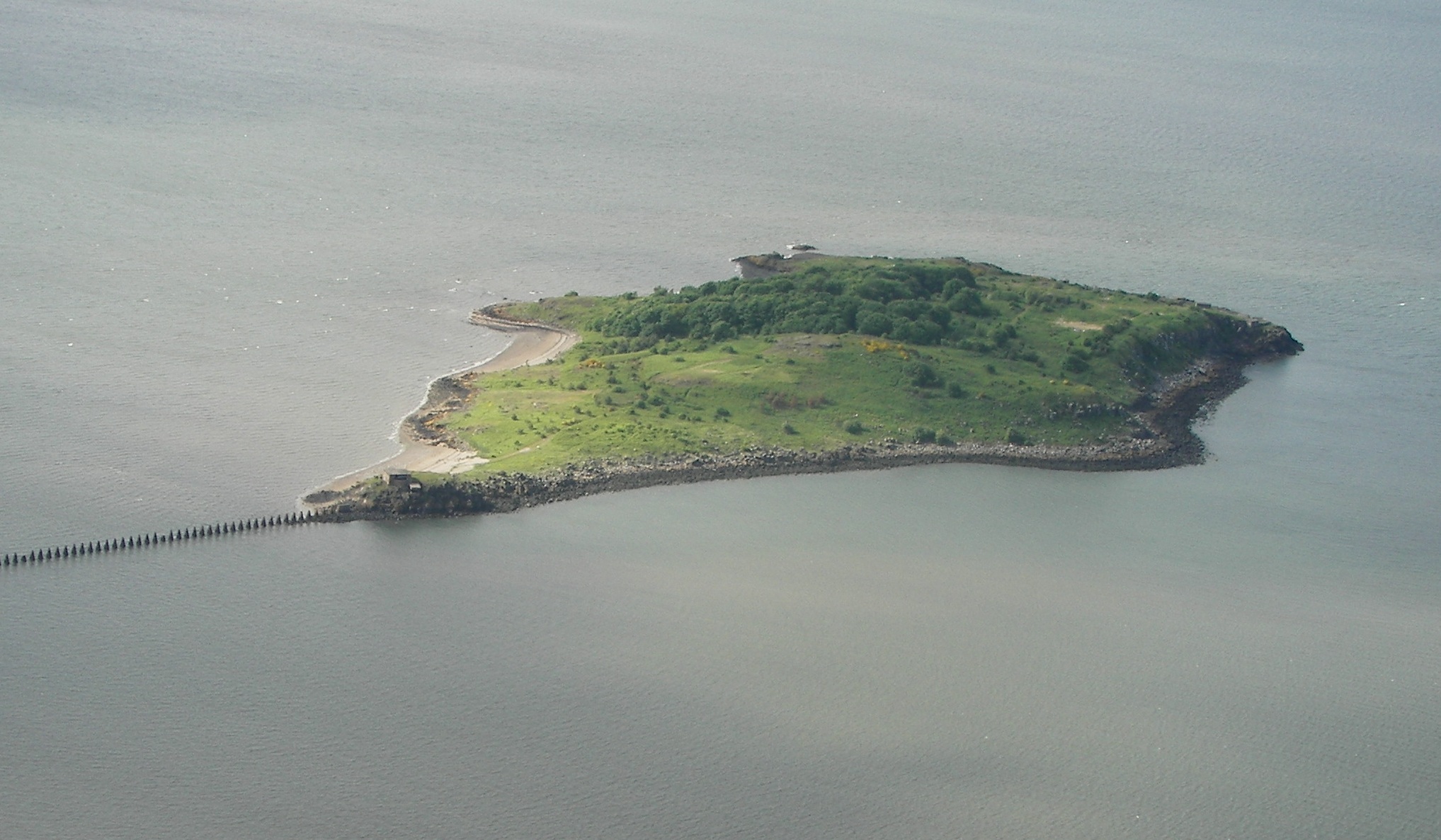
Cow and Calves, Midlothian (Island), is a small uninhabited island located in the Firth of Forth, off the coast of East Lothian, Scotland. The island is commonly referred to as "the Cow and Calves," owing to its distinctive rock formations that resemble a cow and two calves.

Situated approximately 2 kilometers east of North Berwick, the island spans about 800 meters in length and 300 meters in width. Composed largely of sandstone, the island's prominent cliffs rise up to 20 meters above sea level, providing nesting sites for various seabird species, including guillemots, razorbills, and fulmars.

Access to Cow and Calves is primarily by boat, with several tour operators offering trips to the island during the breeding season. Visitors can witness the abundant wildlife and observe the diverse marine ecosystem surrounding the island. The surrounding waters are also frequented by seals, dolphins, and occasionally whales, adding to the attraction for nature enthusiasts.

Despite its small size, Cow and Calves has played a significant role in local folklore and history. Legends tell of smugglers using the island as a hiding place for their illicit activities, taking advantage of its secluded location and treacherous waters. The island's unique rock formations have also inspired artists and photographers, drawing them to capture the beauty of this natural wonder.

As a protected site, Cow and Calves, Midlothian (Island), offers a picturesque destination for nature lovers, history enthusiasts, and those seeking a tranquil escape amidst the rugged beauty of Scotland's coastline.

If you have any feedback on the listing, please let us know in the comments section below.

Cow and Calves Images

Images are sourced within 2km of 56.015776/-3.2744708 or Grid Reference NT2081. Thanks to Geograph Open Source API. All images are credited.

Inchmickery Island Partly demolished wartime jetty, fortifications and military buildings on island in the Firth of Forth
Inchmickery Island
Partly demolished wartime jetty, fortifications and military buildings on island in the Firth of Forth
Inchmickery Inchmickery against an Edinburgh City Skyline. A viewbag of the first order.

Islands of the Forth: <a title="https://www.geograph.org.uk/gallery/islands_of_the_forth_6400" href="https://www.geograph.org.uk/gallery/islands_of_the_forth_6400">Link</a>
Inchmickery
Inchmickery against an Edinburgh City Skyline. A viewbag of the first order. Islands of the Forth: Link
Oxcars Lighthouse from the shore Islands of Car Craig, Oxcars (lighthouse), Cow & Calves, Inchmickery in the background. Aberdour Sailing Club incidentally in foreground.  Most suitable weather vane atop the clubhouse. Blatant viewbag but intended only as a supplemental.
Oxcars Lighthouse from the shore
Islands of Car Craig, Oxcars (lighthouse), Cow & Calves, Inchmickery in the background. Aberdour Sailing Club incidentally in foreground. Most suitable weather vane atop the clubhouse. Blatant viewbag but intended only as a supplemental.
Inchmickery The island showing its profile as a warship which it was made to look like to fool the enemy during the war.
Inchmickery
The island showing its profile as a warship which it was made to look like to fool the enemy during the war.
The Oxcars Lighthouse Photo taken from the Maid of the Forth
The Oxcars Lighthouse
Photo taken from the Maid of the Forth
Inchmickery from Inchcolm Inchmickery and Edinburgh, natural light no filters - my blue period.
Inchmickery from Inchcolm
Inchmickery and Edinburgh, natural light no filters - my blue period.
Jetty on Inchmickery Used for unloading supplies for the military garrison on Inchmickery - note railway track for heavier items.  Forth Railway Bridge in the distance.
Jetty on Inchmickery
Used for unloading supplies for the military garrison on Inchmickery - note railway track for heavier items. Forth Railway Bridge in the distance.
Inchmickery, looking towards the Fife coast Any blurring is because of sustained attack from sea gulls. They were making it clear they didn't appreciate my presence.
Inchmickery, looking towards the Fife coast
Any blurring is because of sustained attack from sea gulls. They were making it clear they didn't appreciate my presence.
Inchmickery From Cramond Taken from Cramond; Inchmickery and Burntisland form the background. The little power boats that can be seen are competitors in the "round Britain" race.
Inchmickery From Cramond
Taken from Cramond; Inchmickery and Burntisland form the background. The little power boats that can be seen are competitors in the "round Britain" race.
Fortifications on Inchmickery Military buildings dating from WW1 and WW2 dominate the skyline of Inchmickery. With a little imagination the fortifications can be seen as making the island resemble a WW2 vintage battleship and it is sometimes claimed this was deliberately done in an attempt to trick enemy U-boats into trying to torpedo it.
Fortifications on Inchmickery
Military buildings dating from WW1 and WW2 dominate the skyline of Inchmickery. With a little imagination the fortifications can be seen as making the island resemble a WW2 vintage battleship and it is sometimes claimed this was deliberately done in an attempt to trick enemy U-boats into trying to torpedo it.
Inchmickery from Silverknowes The extensive WW2 fortifications remain.
Inchmickery from Silverknowes
The extensive WW2 fortifications remain.
Common Seals on deep channel marker buoy Navigation buoy in the Firth of Forth.  The Common Seals <span class="nowrap"><a title="http://en.wikipedia.org/wiki/Common_Seal" rel="nofollow ugc noopener" href="http://en.wikipedia.org/wiki/Common_Seal">Link</a><img style="margin-left:2px;" alt="External link" title="External link - shift click to open in new window" src="https://s1.geograph.org.uk/img/external.png" width="10" height="10"/></span> seem to like these: <a title="https://www.geograph.org.uk/photo/15558" href="https://www.geograph.org.uk/photo/15558">Link</a>

These catmarkers occasionally attract Grey Seals too: <span class="nowrap"><a title="http://www.flickr.com/photos/purplerabbits/2612367777/" rel="nofollow ugc noopener" href="http://www.flickr.com/photos/purplerabbits/2612367777/">Link</a><img style="margin-left:2px;" alt="External link" title="External link - shift click to open in new window" src="https://s1.geograph.org.uk/img/external.png" width="10" height="10"/></span>
Common Seals on deep channel marker buoy
Navigation buoy in the Firth of Forth. The Common Seals LinkExternal link seem to like these: Link These catmarkers occasionally attract Grey Seals too: LinkExternal link
Oxcars Lighthouse At high tide these rocks are covered <a title="https://www.geograph.org.uk/photo/118759" href="https://www.geograph.org.uk/photo/118759">Link</a>
Oxcars Lighthouse
At high tide these rocks are covered Link
Oxcars Lighthouse At high tide these rocks are covered. <a title="https://www.geograph.org.uk/photo/118759" href="https://www.geograph.org.uk/photo/118759">Link</a>
Oxcars Lighthouse
At high tide these rocks are covered. Link
Cow and Calves View from the south of Inchclom toward the Cow and Calves against the Leith coastline.
Cow and Calves
View from the south of Inchclom toward the Cow and Calves against the Leith coastline.
Inchmickery and seabirds With the nesting season underway the Forth was busy with lesser black-backed and herring gulls, kittiwakes, common terns, razorbills, shags, puffins and gannets, of which mainly gulls are visible on the military ruins here.
Inchmickery and seabirds
With the nesting season underway the Forth was busy with lesser black-backed and herring gulls, kittiwakes, common terns, razorbills, shags, puffins and gannets, of which mainly gulls are visible on the military ruins here.
Inchmickery Inchmickery is a small island in the Firth of Forth. During World War II the island was used as a gun emplacement. From a distance, the concrete buildings make the island look like a battleship. According to the tour guide, this was done deliberately to confuse any enemy submarines which ventured into the Forth.

The island is now an RSPB reserve.
Inchmickery
Inchmickery is a small island in the Firth of Forth. During World War II the island was used as a gun emplacement. From a distance, the concrete buildings make the island look like a battleship. According to the tour guide, this was done deliberately to confuse any enemy submarines which ventured into the Forth. The island is now an RSPB reserve.
Oxcars Lighthouse This small lighthouse which sits on the small rock of Oxcars in the middle of the estuary of the River Forth. Between the islands of Inchcolm and Inchmickery. It was designed by Thomas and David A Stevenson for the Northern Lighthouse Board and was first lit in 1886. Originally lit by an oil burner and manned by two keepers, it was the first ever lighthouse in Scotland to be automated when in 1894; at that time it was controlled by a clockwork timer and was powered using gas delivered weekly.

Oxcars Lighthouse is a Category B listed building (Historic Scotland LB49687 <span class="nowrap"><a title="http://portal.historicenvironment.scot/designation/LB49687" rel="nofollow ugc noopener" href="http://portal.historicenvironment.scot/designation/LB49687">Link</a><img style="margin-left:2px;" alt="External link" title="External link - shift click to open in new window" src="https://s1.geograph.org.uk/img/external.png" width="10" height="10"/></span>  ).
Oxcars Lighthouse
This small lighthouse which sits on the small rock of Oxcars in the middle of the estuary of the River Forth. Between the islands of Inchcolm and Inchmickery. It was designed by Thomas and David A Stevenson for the Northern Lighthouse Board and was first lit in 1886. Originally lit by an oil burner and manned by two keepers, it was the first ever lighthouse in Scotland to be automated when in 1894; at that time it was controlled by a clockwork timer and was powered using gas delivered weekly. Oxcars Lighthouse is a Category B listed building (Historic Scotland LB49687 LinkExternal link ).
Show me another place!

Cow and Calves is located at Grid Ref: NT2081 (Lat: 56.015776, Lng: -3.2744708)

Unitary Authority: City of Edinburgh

Police Authority: Edinburgh

What 3 Words

///brains.ground.part. Near Aberdour, Fife

Nearby Locations

Cow and Calves

Related Wikis

Inchmickery

Inchmickery is a small island in the Firth of Forth in Scotland. It is about two miles (3.2 km) north of Edinburgh. Its name comes from the Scottish Gaelic...

Inchcolm

Inchcolm (from the Scottish Gaelic "Innis Choluim", meaning Columba's Island) is an island in the Firth of Forth in Scotland. It was repeatedly attacked...

Inchcolm Abbey

Inchcolm Abbey is a medieval abbey located on the island of Inchcolm in the Firth of Forth in Scotland. The Abbey, which is located at the centre of the...

Cramond Island

Cramond Island (Scottish Gaelic: Eilean Chair Amain) is one of several islands in the Firth of Forth in eastern Scotland, near Edinburgh. It lies off the...

Murder of Sheila Anderson

The murder of Sheila Anderson (1955/1956 – 7 February 1983) was the 1983 murder of a sex worker in Edinburgh which has been described as "one of Scotland...

Granton Shrimp Bed

The Granton Shrimp Bed is a fossil-bearing deposit exposed on the southern shore of the Firth of Forth near Edinburgh, in Scotland. It is classified as...

RMS Campania

RMS Campania was a British ocean liner owned by the Cunard Line, built by Fairfield Shipbuilding and Engineering Company of Govan, Scotland, and launched...

HMS Campania (1914)

HMS Campania was a seaplane tender and aircraft carrier, converted from an elderly ocean liner by the Royal Navy early in the First World War. After her...

Nearby Amenities

Located within 500m of 56.015776,-3.2744708
Source: PGS
Lat/Long: 56.0116563/-3.2751639
Source: PGS
Lat/Long: 56.0119802/-3.275261
Source: PGS
Lat/Long: 56.0121693/-3.2742729
Source: PGS
Lat/Long: 56.0119704/-3.2731121
Source: PGS
Lat/Long: 56.0115718/-3.2727783
Source: PGS
Lat/Long: 56.0114145/-3.2725935
The data included in this document is from www.openstreetmap.org. The data is made available under ODbL.

Have you been to Cow and Calves?

Leave your review of Cow and Calves below (or comments, questions and feedback).