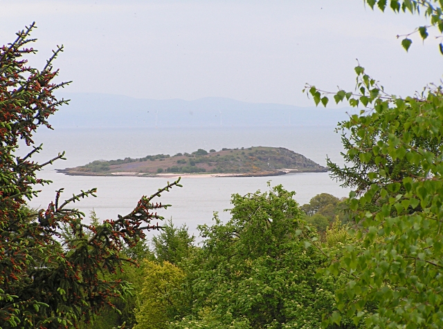
Bells Isle

Island in Kirkcudbrightshire

Scotland

Bells Isle

Carboniferous strata Rocks on the shore to the south of Portling are much younger than those forming the adjacent cliffs which run along the coast. It is immediately obvious that they are not steeply inclined, and in fact they are unconformable with the immediately adjacent Silurian strata (see <a href="https://www.geograph.org.uk/photo/6970240">NX8954 : Tilted strata</a> for a good contrasting example) and post-date the continental collision responsible for the deformation of the older rocks. Sadly, it is not possible to see the older and younger rocks anywhere in contact, and generally here a steeply-inclined fault separates them. See also <a href="https://www.geograph.org.uk/photo/6970311">NX8853 : Carboniferous strata 2</a> for another view of the Carboniferous rocks.
Carboniferous strata Credit: Jonathan Wilkins

Bells Isle, also known as Belle Isle, is a small and picturesque island located off the coast of Kirkcudbrightshire in southwestern Scotland. Situated in the estuary of the River Dee, Bells Isle is approximately 1.5 miles long and covers an area of around 90 acres.

The island is a popular tourist destination due to its stunning natural beauty and rich history. It is home to a diverse range of wildlife, including various species of birds, seals, and otters, making it an ideal spot for nature enthusiasts and birdwatchers. The island's landscape is characterized by rocky shores, sandy beaches, and rolling green hills, providing visitors with ample opportunities for outdoor activities such as hiking, fishing, and boating.

Bells Isle has a long and fascinating history, with evidence of human occupation dating back to prehistoric times. It has been inhabited by various Celtic and Norse communities throughout the centuries, and remnants of their settlements can still be seen today. The island also played a significant role in the smuggling trade during the 18th and 19th centuries.

In addition to its natural and historical attractions, Bells Isle is home to a few holiday cottages, making it a popular destination for those seeking a peaceful and idyllic retreat. The island can be accessed via a small ferry from the nearby town of Kirkcudbright, which adds to its charm and exclusivity.

Overall, Bells Isle is a hidden gem that offers visitors a unique and tranquil escape, combining stunning landscapes, rich history, and abundant wildlife.

If you have any feedback on the listing, please let us know in the comments section below.

Bells Isle Images

Images are sourced within 2km of 54.856904/-3.7647469 or Grid Reference NX8652. Thanks to Geograph Open Source API. All images are credited.

Carboniferous strata Rocks on the shore to the south of Portling are much younger than those forming the adjacent cliffs which run along the coast. It is immediately obvious that they are not steeply inclined, and in fact they are unconformable with the immediately adjacent Silurian strata (see <a href="https://www.geograph.org.uk/photo/6970240">NX8954 : Tilted strata</a> for a good contrasting example) and post-date the continental collision responsible for the deformation of the older rocks. Sadly, it is not possible to see the older and younger rocks anywhere in contact, and generally here a steeply-inclined fault separates them. See also <a href="https://www.geograph.org.uk/photo/6970311">NX8853 : Carboniferous strata 2</a> for another view of the Carboniferous rocks.
Carboniferous strata
Rocks on the shore to the south of Portling are much younger than those forming the adjacent cliffs which run along the coast. It is immediately obvious that they are not steeply inclined, and in fact they are unconformable with the immediately adjacent Silurian strata (see NX8954 : Tilted strata for a good contrasting example) and post-date the continental collision responsible for the deformation of the older rocks. Sadly, it is not possible to see the older and younger rocks anywhere in contact, and generally here a steeply-inclined fault separates them. See also NX8853 : Carboniferous strata 2 for another view of the Carboniferous rocks.
Carboniferous strata 2 The rocks here, of Carboniferous (Arundian to Holkerian) age are the Rascarrel Member of the Fell Sandstone Formation. The beds are of sandstone and conglomerate, which include angular clasts of granite and other igneous material eroded from the exposed granite pluton nearby, indicating rapid uplift on the faults which run along its margin to form a faulted unconformity on the norther margin of the Upper Palaeozoic Solway Basin. See also <a href="https://www.geograph.org.uk/photo/6970289">NX8853 : Carboniferous strata</a>.
Carboniferous strata 2
The rocks here, of Carboniferous (Arundian to Holkerian) age are the Rascarrel Member of the Fell Sandstone Formation. The beds are of sandstone and conglomerate, which include angular clasts of granite and other igneous material eroded from the exposed granite pluton nearby, indicating rapid uplift on the faults which run along its margin to form a faulted unconformity on the norther margin of the Upper Palaeozoic Solway Basin. See also NX8853 : Carboniferous strata.
Portling shore Looking from the intertidal sands to the houses on the Portling Shore. I was impressed by the sky that had developed.
Portling shore
Looking from the intertidal sands to the houses on the Portling Shore. I was impressed by the sky that had developed.
Lichens on sandstone Still in the splash zone, these rocks bear a fantastic community of lichens including Caloplaca, Ramalina and Ochrolechia. What a fabulous garden!
Lichens on sandstone
Still in the splash zone, these rocks bear a fantastic community of lichens including Caloplaca, Ramalina and Ochrolechia. What a fabulous garden!
In Rockliffe Heading for Castlehill Point.
In Rockliffe
Heading for Castlehill Point.
Colvend Parish Church An Early Christian church by P MacGregor Chalmers 1911, of granite with red sandstone dressings and set on a rise overlooking the Solway Firth. Its bell-tower is topped by a steep pyramid roof.
Colvend Parish Church
An Early Christian church by P MacGregor Chalmers 1911, of granite with red sandstone dressings and set on a rise overlooking the Solway Firth. Its bell-tower is topped by a steep pyramid roof.
Colvend House Just to the left of the house, through a gap between the trees, is White Loch.
Colvend House
Just to the left of the house, through a gap between the trees, is White Loch.
Castlehill Point, viewpoint
Rough Firth
Rough Firth
Rockpool at Port o' Warren Bay
Coast below Barclow Hill
Small inlet at low tide
Castlehill Point, viewpoint toposcope
The Mill Burn The Mill Burn where it enters Rough Firth, photographed from the coastal path footbridge.
The Mill Burn
The Mill Burn where it enters Rough Firth, photographed from the coastal path footbridge.
Rocky shoreline, Rough Firth Lichen-encrusted rocks on the shore, south of Rockcliffe. Almorness Point and Hestan Island are in the distance.
Rocky shoreline, Rough Firth
Lichen-encrusted rocks on the shore, south of Rockcliffe. Almorness Point and Hestan Island are in the distance.
End of the track, Glenurr Through the gate on the right is a house called Glenurr. Going through the kissing gate takes you through a field to Castle Point, seen in the distance.
End of the track, Glenurr
Through the gate on the right is a house called Glenurr. Going through the kissing gate takes you through a field to Castle Point, seen in the distance.
Coastguard sign Sign on the gate beside the entrance to Glenurr [<a title="https://www.geograph.org.uk/photo/4695750" href="https://www.geograph.org.uk/photo/4695750">Link</a>]. This is a ready-made geograph - they have very kindly given the grid reference on the sign!
Coastguard sign
Sign on the gate beside the entrance to Glenurr [Link]. This is a ready-made geograph - they have very kindly given the grid reference on the sign!
Boreland of Colvend Looking from White Hill towards Rough Island. The farm is half hidden in the dip.
Boreland of Colvend
Looking from White Hill towards Rough Island. The farm is half hidden in the dip.
Show me another place!

Bells Isle is located at Grid Ref: NX8652 (Lat: 54.856904, Lng: -3.7647469)

Unitary Authority: Dumfries and Galloway

Police Authority: Dumfries and Galloway

What 3 Words

///reflected.revolts.parsnip. Near Dalbeattie, Dumfries & Galloway

Related Wikis

Colvend and Southwick

Colvend and Southwick is a community council area and civil parish within the Stewartry area of Dumfries and Galloway, Scotland. It is also part of the...

Rough Island, Scotland

"Rough Island" is also used as a translation of "Garbh Eilean", a common Scottish name for islandsRough Island is a 20-acre (8 ha) uninhabited tidal island...

Rough Firth

Rough Firth is an inlet on the northern coast of the Solway Firth in the Stewartry area of Dumfries and Galloway, Scotland. The firth lies between Almorness...

Rockcliffe, Dumfries and Galloway

Rockcliffe is a small, coastal village in Kirkcudbrightshire, Dumfries and Galloway in Scotland, with a view of Rough Island, Hestan Island, the Solway...

Nearby Amenities

Located within 500m of 54.856904,-3.7647469
Source: PGS
Lat/Long: 54.8561543/-3.7713203
Source: PGS
Lat/Long: 54.8560013/-3.7709269
Source: PGS
Lat/Long: 54.8564982/-3.7693669
Source: PGS
Lat/Long: 54.8565815/-3.7686744
Source: PGS
Lat/Long: 54.8567322/-3.768271
Source: PGS
Lat/Long: 54.8565436/-3.7680119
Source: PGS
Lat/Long: 54.8565414/-3.767638
Source: PGS
Lat/Long: 54.8567585/-3.7669969
Source: PGS
Lat/Long: 54.8567545/-3.7665388
Source: PGS
Lat/Long: 54.8569076/-3.7663275
Source: PGS
Lat/Long: 54.85697/-3.7656006
Source: PGS
Lat/Long: 54.8568842/-3.7651854
Source: PGS
Lat/Long: 54.8568971/-3.7647289
Source: PGS
Lat/Long: 54.8563892/-3.7635895
Source: PGS
Lat/Long: 54.8566498/-3.7623385
Source: PGS
Lat/Long: 54.856831/-3.7616084
Source: PGS
Lat/Long: 54.8569888/-3.7613251
Source: PGS
Lat/Long: 54.8571923/-3.7611057
Source: PGS
Lat/Long: 54.8572837/-3.7606632
Source: PGS
Lat/Long: 54.8573974/-3.7602877
Source: PGS
Lat/Long: 54.8576425/-3.7602474
Source: PGS
Lat/Long: 54.8579374/-3.7602501
Source: PGS
Lat/Long: 54.858043/-3.7599207
Source: PGS
Lat/Long: 54.8581239/-3.7593628
Source: PGS
Lat/Long: 54.8583765/-3.7592287
Source: PGS
Lat/Long: 54.8586328/-3.7587507
Source: PGS
Lat/Long: 54.8589721/-3.7578672
Bogle Hole
Place: locality
Lat/Long: 54.8562297/-3.7716963
Gutcher's Isle
Place: locality
Lat/Long: 54.856376/-3.7714161
Bells Isle
Place: locality
Lat/Long: 54.8568068/-3.7655908
Historic: memorial
Lat/Long: 54.85688/-3.7641705
The data included in this document is from www.openstreetmap.org. The data is made available under ODbL.

Have you been to Bells Isle?

Leave your review of Bells Isle below (or comments, questions and feedback).