An Corr-eilean

Island in Inverness-shire

Scotland

An Corr-eilean

East ridge of Beinn Bhuidhe Looking east towards Sgurr na Ciche.
East ridge of Beinn Bhuidhe Credit: wrobison

An Corr-eilean, also known as Corrie Island, is a small, uninhabited island located off the coast of Inverness-shire in Scotland. The island is situated in the Inner Hebrides and is part of the Inner Sound group of islands.

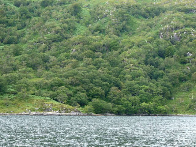
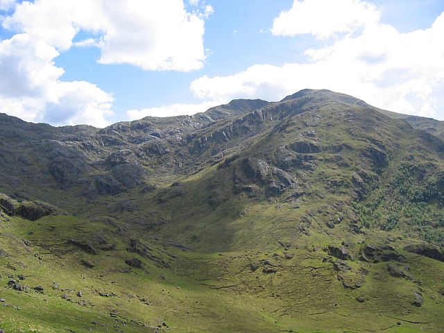
An Corr-eilean is relatively small in size, measuring just over 1 mile in length and 0.5 miles in width. The island is characterized by rugged, rocky terrain and is surrounded by clear, turquoise waters. It offers stunning views of the surrounding sea and neighboring islands.

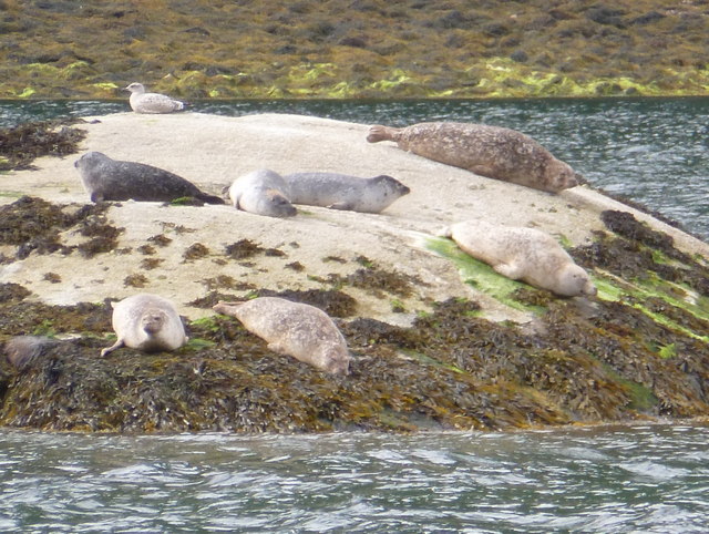
Despite its small size, An Corr-eilean is home to a variety of wildlife, including seabirds, seals, and otters. The island is a popular destination for birdwatchers and nature enthusiasts looking to observe the diverse range of bird species that inhabit the area.

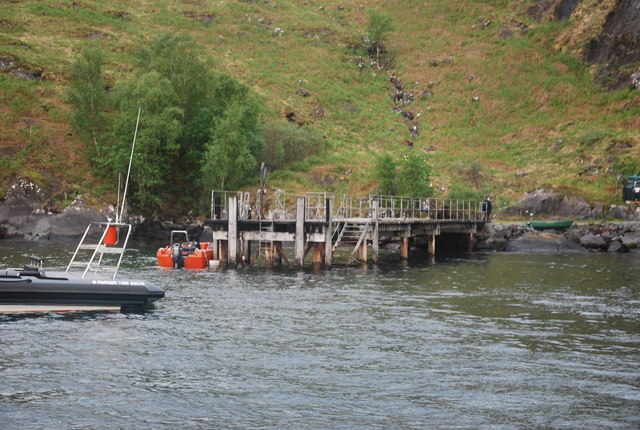
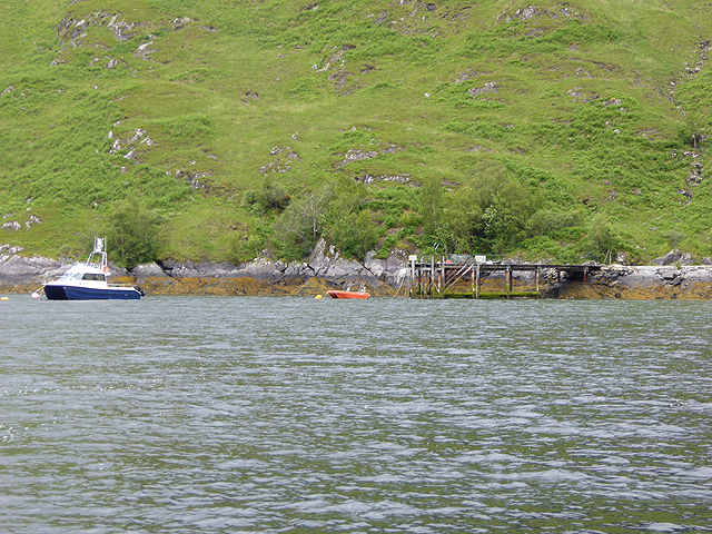
Access to An Corr-eilean is limited, with no regular ferry service to the island. However, visitors can arrange private boat trips or kayak excursions to explore the island and its surrounding waters. Overall, An Corr-eilean offers a peaceful and remote escape for those looking to experience the natural beauty of the Scottish coastline.

If you have any feedback on the listing, please let us know in the comments section below.

An Corr-eilean Images

Images are sourced within 2km of 56.996474/-5.5550611 or Grid Reference NM8495. Thanks to Geograph Open Source API. All images are credited.

East ridge of Beinn Bhuidhe Looking east towards Sgurr na Ciche.
East ridge of Beinn Bhuidhe
Looking east towards Sgurr na Ciche.
Looking Into the Rough Bounds From high up the eastern ridge of the Corbett of Beinne Bhuidhe there is a fine view to the rough steep peaks of Ben Aden, Sgurr na Ciche and Garbh Chioch Mhor. Some of the roughest and steepest hills in Scotland.
Looking Into the Rough Bounds
From high up the eastern ridge of the Corbett of Beinne Bhuidhe there is a fine view to the rough steep peaks of Ben Aden, Sgurr na Ciche and Garbh Chioch Mhor. Some of the roughest and steepest hills in Scotland.
Untitled Ruin This may have been a sheiling as it is so small. It lies by the shore between two burns one of which drains the north slopes of the long western ridge of the Corbett, Sgurr na h-Aide
Untitled Ruin
This may have been a sheiling as it is so small. It lies by the shore between two burns one of which drains the north slopes of the long western ridge of the Corbett, Sgurr na h-Aide
Camusrory Pier Approaching the pier to drop off walkers who were heading up Beinn Bhuidhe via Mam Meadail.
Camusrory Pier
Approaching the pier to drop off walkers who were heading up Beinn Bhuidhe via Mam Meadail.
Allt  Salach-airigh A burn which drains the upper slopes of Beinn Buidhe entry point into Loch Nevis.
Allt Salach-airigh
A burn which drains the upper slopes of Beinn Buidhe entry point into Loch Nevis.
Coille Chaolais Natural woods near Rubha Dubh a' Bhàta

.
Coille Chaolais
Natural woods near Rubha Dubh a' Bhàta .
Loch Nevis: seals on a rock A number of seals on a small rock on the northern edge of Loch Nevis.
Loch Nevis: seals on a rock
A number of seals on a small rock on the northern edge of Loch Nevis.
Storage Sheds, Camusrory
Eilean Alasdair It  is just possible to make out the small island offshore from the north shore of Loch Nevis and the wooded slopes of Coille Chaolais.
Eilean Alasdair
It is just possible to make out the small island offshore from the north shore of Loch Nevis and the wooded slopes of Coille Chaolais.
Allt Salach-airigh On the north shore of Loch Nevis. The summit of Beinn Buidhe (855 metres) <a href="https://www.geograph.org.uk/gridref/NM8296">NM8296</a> on the skyline to the left.
Allt Salach-airigh
On the north shore of Loch Nevis. The summit of Beinn Buidhe (855 metres) NM8296 on the skyline to the left.
An Corr-eilean Small rocky islet off the north shore of Loch Nevis.
An Corr-eilean
Small rocky islet off the north shore of Loch Nevis.
Camusrory Pier Pier at the head of Loch Nevis, servicing the keepers cottage just up the glen.
Camusrory Pier
Pier at the head of Loch Nevis, servicing the keepers cottage just up the glen.
Landing at Rubh' an Torra Chruinn Making a landing by dinghy prior to the long walk back to Inverie.
Landing at Rubh' an Torra Chruinn
Making a landing by dinghy prior to the long walk back to Inverie.
South shore of Loch Nevis near its head Peak is Sgùrr na Cìche.
South shore of Loch Nevis near its head
Peak is Sgùrr na Cìche.
Ben Aden from below Bac Gobhar
The bay at Camusrory
North shore of Loch Nevis
An Corr-eilean near the head of Loch Nevis
Show me another place!

An Corr-eilean is located at Grid Ref: NM8495 (Lat: 56.996474, Lng: -5.5550611)

Unitary Authority: Highland

Police Authority: Highlands and Islands

What 3 Words

///selling.unusable.earful. Near Arisaig, Highland

Related Wikis

Beinn Bhuidhe (Knoydart)

Beinn Bhuidhe (855m) is a mountain in the Northwest Highlands of Scotland. It lies in a very remote area of Knoydart, Lochaber. Lying on the north side...

Meall Buidhe, Knoydart

Meall Buidhe (946 m) is a mountain in the Northwest Highlands, Scotland. It lies on the Knoydart peninsula in Lochaber. A rocky mountain, Meall Buidhe...

Bidein a' Chabair

Bidein a' Chabair (867 m) is a mountain in the Knoydart peninsula, Lochaber, on the west coast of Scotland. It is part of the Northwest Highlands. A conical...

Tarbet, Loch Nevis

Tarbet (Scottish Gaelic: An Tairbeart or Tairbeart Loch Nibheis) is a place on the south shore of Loch Nevis in Scotland, about 6 miles (10 kilometres...

Nearby Amenities

Located within 500m of 56.996474,-5.5550611
Created By: dmgroom_coastlines
Source: PGS
Lat/Long: 56.994854/-5.562201
Created By: dmgroom_coastlines
Source: PGS
Lat/Long: 56.994864/-5.561733
Created By: dmgroom_coastlines
Source: PGS
Lat/Long: 56.994874/-5.561264
Created By: dmgroom_coastlines
Source: PGS
Lat/Long: 56.995007/-5.56104
Created By: dmgroom_coastlines
Source: PGS
Lat/Long: 56.995139/-5.560813
Created By: dmgroom_coastlines
Source: PGS
Lat/Long: 56.995423/-5.559425
Created By: dmgroom_coastlines
Source: PGS
Lat/Long: 56.995557/-5.5592
Created By: dmgroom_coastlines
Source: PGS
Lat/Long: 56.995689/-5.558974
Created By: dmgroom_coastlines
Source: PGS
Lat/Long: 56.995822/-5.558749
Created By: dmgroom_coastlines
Source: PGS
Lat/Long: 56.995954/-5.558523
Source: PGS
Lat/Long: 56.9963884/-5.5578944
Created By: dmgroom_coastlines
Source: PGS
Lat/Long: 56.996618/-5.557396
Created By: dmgroom_coastlines
Source: PGS
Lat/Long: 56.99675/-5.557169
Created By: dmgroom_coastlines
Source: PGS
Lat/Long: 56.996769/-5.556232
Source: PGS
Lat/Long: 56.9966119/-5.555121
Source: PGS
Lat/Long: 56.9959516/-5.5554883
Source: PGS
Lat/Long: 56.9961196/-5.5547067
Source: PGS
Lat/Long: 56.9966233/-5.5545227
Source: PGS
Lat/Long: 56.9967156/-5.5540726
Created By: dmgroom_coastlines
Source: PGS
Lat/Long: 56.997197/-5.55415
Source: PGS
Lat/Long: 56.9973255/-5.554476
Source: PGS
Lat/Long: 56.9975355/-5.5543189
Source: PGS
Lat/Long: 56.998173/-5.5535035
Source: PGS
Lat/Long: 56.9986715/-5.5528592
Source: PGS
Lat/Long: 56.9988287/-5.5524391
Source: PGS
Lat/Long: 56.9988901/-5.5522917
Source: PGS
Lat/Long: 56.9992407/-5.5512854
Source: PGS
Lat/Long: 56.9992725/-5.5507381
Source: PGS
Lat/Long: 56.9990326/-5.5496154
Source: PGS
Lat/Long: 56.9989272/-5.5492426
The data included in this document is from www.openstreetmap.org. The data is made available under ODbL.

Have you been to An Corr-eilean?

Leave your review of An Corr-eilean below (or comments, questions and feedback).