Am Sean Chreag

Island in Ross-shire

Scotland

Am Sean Chreag

Stacks below Creag Camas an Fhraoich
Stacks below Creag Camas an Fhraoich Credit: Alpin Stewart

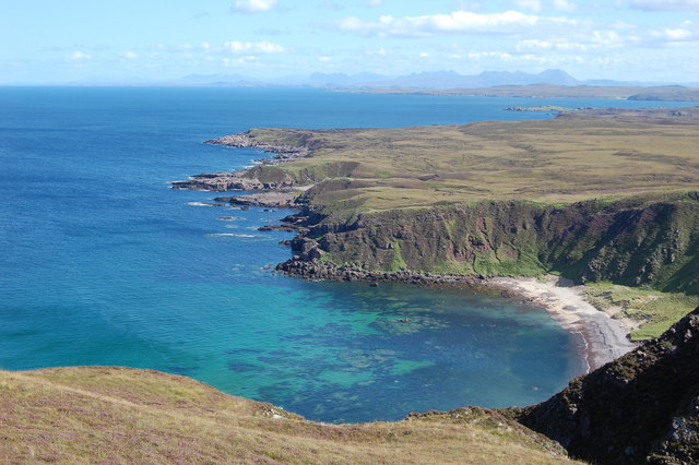
Am Sean Chreag is a small island located off the coast of Ross-shire, in the Highlands region of Scotland. The island is situated in the picturesque Dornoch Firth, surrounded by stunning natural beauty.

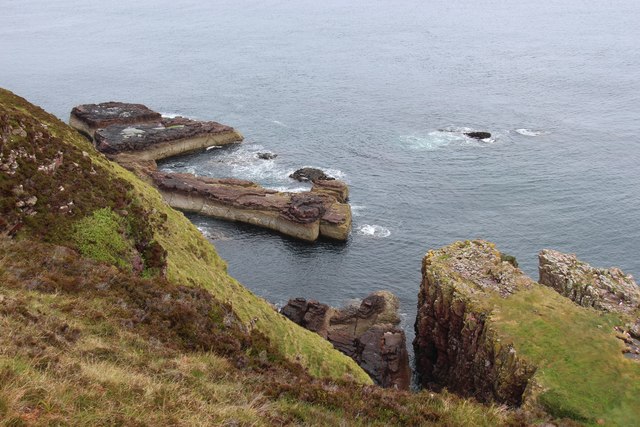
With an area of approximately 10 acres, Am Sean Chreag is a relatively small island, but it boasts a diverse range of habitats and wildlife. The island is characterized by rugged terrain, with rocky cliffs and sloping hillsides covered in heather and grasses. The coastline is also dotted with small sandy beaches and tide pools.

Am Sean Chreag is home to a variety of bird species, including seabirds such as puffins, guillemots, and razorbills. These birds can often be seen nesting on the rocky cliffs, providing a unique opportunity for birdwatching enthusiasts. The island is also a popular spot for seals, which can be spotted lounging on the rocks or swimming in the surrounding waters.

Access to Am Sean Chreag is limited, as there are no regular ferry services to the island. However, it can be reached by private boat or kayak, making it a popular destination for those seeking a remote and peaceful getaway. The island offers opportunities for hiking, nature exploration, and picnicking, allowing visitors to immerse themselves in the unspoiled natural beauty of the Scottish Highlands.

Overall, Am Sean Chreag is a hidden gem in Ross-shire, offering a tranquil escape from the bustling mainland. Its rugged cliffs, diverse wildlife, and stunning landscapes make it a must-visit destination for nature lovers and adventurers alike.

If you have any feedback on the listing, please let us know in the comments section below.

Am Sean Chreag Images

Images are sourced within 2km of 57.864796/-5.7728962 or Grid Reference NG7692. Thanks to Geograph Open Source API. All images are credited.

Stacks below Creag Camas an Fhraoich
Looking down to Camas Mòr
Ruins at Camustrolvaig
Stac Dubh
Stac Dubh
Sea stack with natural arch
Rock girt bay at Camas Mòr
Camas Mòr
Camas Mòr
Loch nan Eun View towards Greenstone Point.
Loch nan Eun
View towards Greenstone Point.
Moorland above Loch nan Eun Typical of the area, peat hags and scattered rock outcrops bring variety to the moorland scene. The mountains of Letterewe Forest are on the left.
Moorland above Loch nan Eun
Typical of the area, peat hags and scattered rock outcrops bring variety to the moorland scene. The mountains of Letterewe Forest are on the left.
Bogbean emerging from a moorland pool Loch Ewe and the remote Fisherfield Forest mountains on the left.
Bogbean emerging from a moorland pool
Loch Ewe and the remote Fisherfield Forest mountains on the left.
View of Camas Mor Our affectionate family name for this beautiful and remote beach is 'The Spooky Beach'. Remote as it is, there's always a feeling you're being watched...
View of Camas Mor
Our affectionate family name for this beautiful and remote beach is 'The Spooky Beach'. Remote as it is, there's always a feeling you're being watched...
Ivors Bothy The bothy has a recently repaired roof after being damaged by fire following a cooking stove accident a couple of years ago.
Ivors Bothy
The bothy has a recently repaired roof after being damaged by fire following a cooking stove accident a couple of years ago.
Eastern end of Camas Beag Camas Beag is a small sandy beach although at low tide the eastern end of it shown here consists of exposed rocks.
Eastern end of Camas Beag
Camas Beag is a small sandy beach although at low tide the eastern end of it shown here consists of exposed rocks.
Old fence beside the Loch
Tree over the track This section of the track is somewhat more solid underfoot than the rest of this track which in many places seems to be somewhat more lake than ground.
Tree over the track
This section of the track is somewhat more solid underfoot than the rest of this track which in many places seems to be somewhat more lake than ground.
View across Camas Mòr
Sea Stacks west of Camas Beag
View across Camas Dubh
Show me another place!

Am Sean Chreag is located at Grid Ref: NG7692 (Lat: 57.864796, Lng: -5.7728962)

Unitary Authority: Highland

Police Authority: Highlands and Islands

What 3 Words

///funky.aware.diplomas. Near Gairloch, Highland

Related Wikis

Rua Reidh Lighthouse

Rua Reidh Lighthouse stands close to the entrance to Loch Ewe in Wester Ross, Scotland. == History == The name "Rua Reidh" is a semi-anglicisation of...

Cove, Highland

Cove is a remote hamlet located on the northwestern shore of the sea loch Loch Ewe, and 8 mi (13 km) northwest of Poolewe in Ross-shire, Scottish Highlands...

Melvaig

Melvaig is a remote village on the coast of western Ross-shire, Scottish Highlands and is in the Scottish council area of Highland. It is a cliff top...

Aultgrishan

Aultgrishan (Gaelic: ) is a small crofting community near Gairloch, Ross-shire. It adjoins Melvaig, within Highland region and is in the Scottish council...

Nearby Amenities

Located within 500m of 57.864796,-5.7728962
Source: PGS
Lat/Long: 57.865924/-5.7661993
Source: PGS
Lat/Long: 57.8659753/-5.7662998
Source: PGS
Lat/Long: 57.8660761/-5.7677061
Source: PGS
Lat/Long: 57.8656834/-5.7691702
Source: PGS
Lat/Long: 57.8654571/-5.7700777
Source: PGS
Lat/Long: 57.8646457/-5.7707133
Source: PGS
Lat/Long: 57.8646985/-5.7709908
Source: PGS
Lat/Long: 57.864651/-5.771168
Created By: almien_coastlines
Source: PGS
Lat/Long: 57.864595/-5.771279
Source: PGS
Lat/Long: 57.8648365/-5.7728031
Source: PGS
Lat/Long: 57.863965/-5.7722644
Source: PGS
Lat/Long: 57.863762/-5.7722105
Source: PGS
Lat/Long: 57.8635347/-5.7732083
Source: PGS
Lat/Long: 57.863638/-5.7740559
Source: PGS
Lat/Long: 57.8633694/-5.7741465
Source: PGS
Lat/Long: 57.862402/-5.7742479
Source: PGS
Lat/Long: 57.862458/-5.7746242
Source: PGS
Lat/Long: 57.8622/-5.7757083
Source: PGS
Lat/Long: 57.861756/-5.7756946
Source: PGS
Lat/Long: 57.861621/-5.7761997
Source: PGS
Lat/Long: 57.861055/-5.7769517
The data included in this document is from www.openstreetmap.org. The data is made available under ODbL.

Have you been to Am Sean Chreag?

Leave your review of Am Sean Chreag below (or comments, questions and feedback).