An Clèiteadh
Island in Argyllshire
Scotland
An Clèiteadh
An Clèiteadh, also known as the Isle of Coll, is a small island located off the west coast of Scotland in Argyllshire. It is part of the Inner Hebrides archipelago and covers an area of approximately 13 square miles. The island is known for its stunning natural beauty, with sandy beaches, rugged cliffs, and rolling hills.
An Clèiteadh has a population of around 200 people, and the main settlement is Arinagour, where most of the island's facilities can be found. The island has a rich history, with evidence of human habitation dating back thousands of years. It is home to several ancient ruins, including the 15th-century Breachacha Castle and the 18th-century Hogh Castle.
The island is a popular destination for outdoor enthusiasts, offering a range of activities such as hiking, birdwatching, and wildlife spotting. An Clèiteadh is known for its diverse ecosystem, with a variety of plant and animal species. It is particularly renowned for its birdlife, with numerous seabird colonies and a large population of corncrakes.
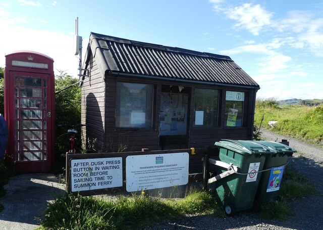
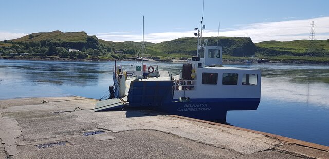
The island has a strong sense of community, with regular events and gatherings throughout the year. It also has a primary school, a medical center, and a few shops and cafes. An Clèiteadh is accessible by ferry from the mainland, with regular services connecting it to Oban.
Overall, An Clèiteadh is a picturesque and tranquil island, offering visitors a chance to immerse themselves in nature and experience the unique culture and history of the Inner Hebrides.
If you have any feedback on the listing, please let us know in the comments section below.
An Clèiteadh Images
Images are sourced within 2km of 56.262315/-5.6242842 or Grid Reference NM7513. Thanks to Geograph Open Source API. All images are credited.
![Torsa from Luing The land in the foreground is the western coast of the isle of Luing at its northern end, looking across to the uninhabited isle of Torsa.
Torsa is almost connected (fordable at low tide) to Luing near Ardinamir Bay.
Although no longer permanently inhabited since the early 1960s, it is possible to stay in a holiday let in the island&#039;s only remaining house - see <span class="nowrap"><a title="https://torsa-island.co.uk" rel="nofollow ugc noopener" href="https://torsa-island.co.uk">Link</a><img style="margin-left:2px;" alt="External link" title="External link - shift click to open in new window" src="https://s1.geograph.org.uk/img/external.png" width="10" height="10"/></span>
The island has never had a large population, but at the beginning of the C19th there were eleven families living here. It has an area of 113ha (280 acres) and its highest point, 62m (203&#039;) is an unnamed hill in the centre of the island.
See also <a href="https://www.geograph.org.uk/photo/7258530">NM7512 : Torsa Beag and Sgeir a' Bhodaich from Luing</a>
[Edit Late 2023] The entire island of Torsa comprising Torsa, Torsa Beag, Eilean na h-Eaglaise, and their reclaimed foreshore is currently up for sale for &quot;offers over £1.5m&quot; - you do get about 270 acres and several buildings for your money though! See <span class="nowrap"><a title="https://island-seeker.com/islands-for-sale/scotland" rel="nofollow ugc noopener" href="https://island-seeker.com/islands-for-sale/scotland">Link</a><img style="margin-left:2px;" alt="External link" title="External link - shift click to open in new window" src="https://s1.geograph.org.uk/img/external.png" width="10" height="10"/></span>](https://s2.geograph.org.uk/geophotos/07/25/83/7258358_d28f3352.jpg)

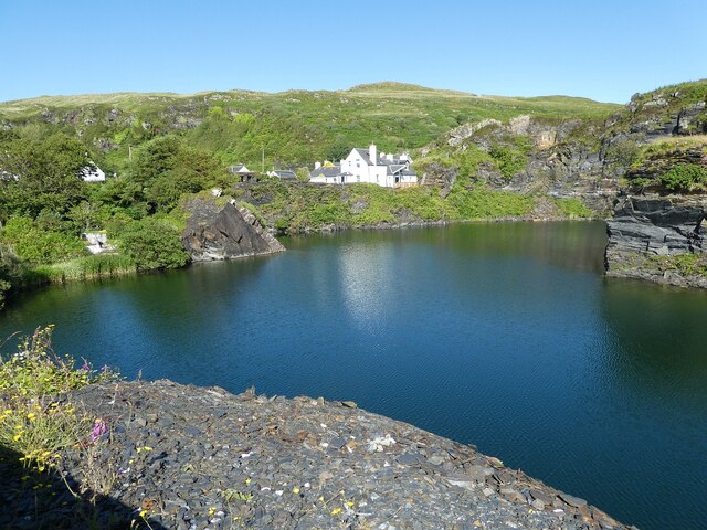
![Luing - Cullipool - Flooded quarry view southwards The flooded quarry to the south of the main part of the village of Cullipool on Luing is roughly L-shaped (though upside down and mirrored)
This view is southwards along the longer arm of the L. I think that the white house in the distance must be a newly built property [2022] as it appears neither on the large scale maps nor on aerial images.](https://s3.geograph.org.uk/geophotos/07/25/96/7259687_523f40bc.jpg)

An Clèiteadh is located at Grid Ref: NM7513 (Lat: 56.262315, Lng: -5.6242842)
Unitary Authority: Argyll and Bute
Police Authority: Argyll and West Dunbartonshire
What 3 Words
///grafted.purest.cringe. Near Lochbuie, Argyll & Bute
Nearby Locations
Related Wikis

Cuan Sound
Cuan Sound is a narrow channel, 200 metres (660 ft) wide, located in Argyll, western Scotland. It separates Seil and Luing and later becomes the Firth...

Torsa
Torsa (occasionally Torsay) is one of the Slate Islands in Argyll and Bute, Scotland. Lying east of Luing and south of Seil, this tidal island was inhabited...

Slate Islands
The Slate Islands are an island group in the Inner Hebrides, lying immediately off the west coast of Scotland, north of Jura and southwest of Oban. The...
Balvicar
Balvicar (Scottish Gaelic: Baile a' Bhiocair) is a village on the island of Seil, a small island seven miles (eleven kilometres) southwest of Oban, Scotland...
Related Videos
Ok, I think I've found my new favourite place - welcome to Easdale on the west coast of Scotland!
Easdale is one of the Slate Isles, about 15 miles south of Oban on the west coast of Scotland. The island has a fascinating history, ...

Argyll Journeys Episode 1 - Kentallen, Port Appin, Easdale and Bealach na Gaoithe
Argyll is a fascinating place to visit, with many options for cycling and walking trips, and the chance to visit unique events as well.

Luing Scotland a Iner Hebrides Jewel just south of Oban
Sure, here is an information section for your YouTube video to the Isle of Luing, Scotland: The Isle of Luing The Isle of Luing is a ...
Easdale Island (4K)
Unique island, and a unique way of getting across to the island. Beautiful scenery as well. And showing one of the shortest ferry ...
Nearby Amenities
Located within 500m of 56.262315,-5.6242842Have you been to An Clèiteadh?
Leave your review of An Clèiteadh below (or comments, questions and feedback).