White's Rock

Island in Argyllshire

Scotland

White's Rock

View towards Eilean Mòr, Isle of Mull
View towards Eilean Mòr, Isle of Mull Credit: Claire Pegrum

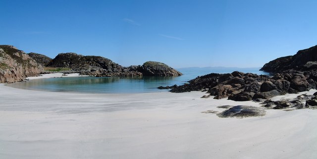
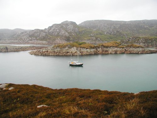
White's Rock is a small island located off the west coast of Scotland, specifically in Argyllshire. Situated in the Firth of Lorn, it is part of the Inner Hebrides archipelago. The island is renowned for its distinctive white color, which is the result of its chalky composition.

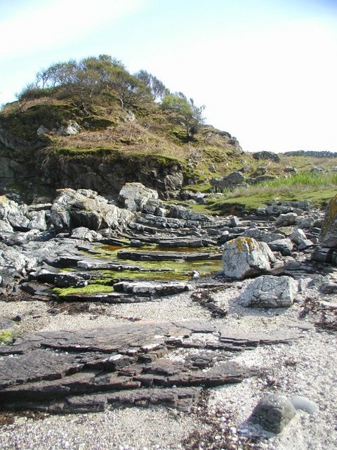
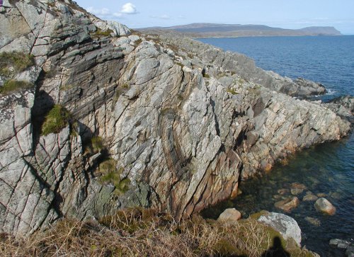
Measuring approximately 500 meters in length and 250 meters in width, White's Rock boasts stunning rugged cliffs that rise dramatically from the surrounding turquoise waters. The island is uninhabited, with no permanent structures or facilities. It is a designated bird sanctuary, providing a safe haven for various species of seabirds, including puffins, guillemots, and razorbills.

Access to White's Rock is limited, as it can only be reached by boat or kayak. The island's remote location and lack of amenities make it an ideal destination for nature enthusiasts, birdwatchers, and photographers seeking solitude and unspoiled landscapes. Visitors can enjoy breathtaking views, peaceful walks along the shoreline, and the opportunity to observe diverse birdlife in their natural habitat.

Due to its exposed location in the Firth of Lorn, White's Rock experiences strong currents and challenging sea conditions. Therefore, it is essential for visitors to exercise caution and adhere to safety guidelines when navigating the waters surrounding the island.

White's Rock offers a unique and tranquil escape from the hustle and bustle of daily life. Its natural beauty, untouched landscapes, and abundant birdlife make it a hidden gem within the Argyllshire region, attracting those seeking a peaceful retreat in a stunning coastal setting.

If you have any feedback on the listing, please let us know in the comments section below.
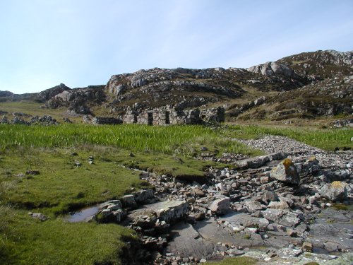
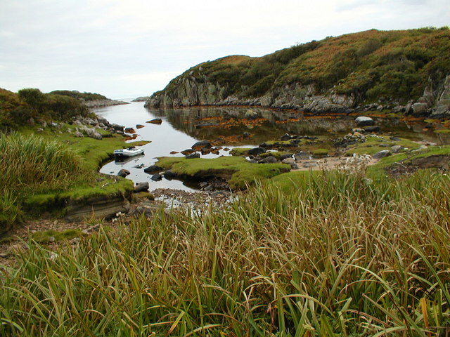
White's Rock Images

Images are sourced within 2km of 56.265293/-6.2743503 or Grid Reference NM3516. Thanks to Geograph Open Source API. All images are credited.

View towards Eilean Mòr, Isle of Mull
Traigh Gheal The path to the beach leads down through birch and scrub willow woodland.
Traigh Gheal
The path to the beach leads down through birch and scrub willow woodland.
Traigh Gheal A view taken at the eastern end of this beautiful, remote beach.
Traigh Gheal
A view taken at the eastern end of this beautiful, remote beach.
The anchorage at  Rubh  Ardalanish A wild, remote spot on the Ross of Mull. The rock here is all granite but nearby there is metamorphic rock where garnets can be found on the beach. A lonely place now but there is much of evidence of former habitation around the bay.
The anchorage at Rubh Ardalanish
A wild, remote spot on the Ross of Mull. The rock here is all granite but nearby there is metamorphic rock where garnets can be found on the beach. A lonely place now but there is much of evidence of former habitation around the bay.
Rubh' Ardalanish Some interesting geology here - this part of the Headland of Rubh' Ardalanish is in the contact zone between the Ross of Mull granite to the west and an area of schist to the east. The landscape is rugged and spectacular. Remote now, there is much evidence of former habitation.
Rubh' Ardalanish
Some interesting geology here - this part of the Headland of Rubh' Ardalanish is in the contact zone between the Ross of Mull granite to the west and an area of schist to the east. The landscape is rugged and spectacular. Remote now, there is much evidence of former habitation.
Xenoliths The patches of darker rock set into the pinkish Ross of Mull granite are 'Xenoliths' - lumps of the surrounding rock which broke off and fell into the molten granite while it was deep underground. It has since solidified and been exposed on the surface by erosion.
Xenoliths
The patches of darker rock set into the pinkish Ross of Mull granite are 'Xenoliths' - lumps of the surrounding rock which broke off and fell into the molten granite while it was deep underground. It has since solidified and been exposed on the surface by erosion.
Ruined Cottage A sad reminder that people once lived and worked in this beautiful place. There are piles of stones cleared from the ground to show that the land was cultivated and several other cottages in the vicinity saying that it was a good place to make a living.
Ruined Cottage
A sad reminder that people once lived and worked in this beautiful place. There are piles of stones cleared from the ground to show that the land was cultivated and several other cottages in the vicinity saying that it was a good place to make a living.
Creek north of Rubh Ardalanish Coastal land between Torr na Sealga and Beinn a Chaol-airigh to the north of the anchorage on Rubh Ardalanish
Creek north of Rubh Ardalanish
Coastal land between Torr na Sealga and Beinn a Chaol-airigh to the north of the anchorage on Rubh Ardalanish
Tràigh Gheal Following in the footsteps of David Balfour, the hero of Robert Louis Stevenson's Kidnapped, as he makes his way back to Edinburgh to confront his wicked uncle.

Stage 1, June 2016 from Erraid to Fishnish on the Isle of Mull.

See <span class="nowrap"><a title="http://www.stevensonway.org.uk" rel="nofollow ugc noopener" href="http://www.stevensonway.org.uk">Link</a><img style="margin-left:2px;" alt="External link" title="External link - shift click to open in new window" src="https://s1.geograph.org.uk/img/external.png" width="10" height="10"/></span>
Tràigh Gheal
Following in the footsteps of David Balfour, the hero of Robert Louis Stevenson's Kidnapped, as he makes his way back to Edinburgh to confront his wicked uncle. Stage 1, June 2016 from Erraid to Fishnish on the Isle of Mull. See LinkExternal link
Tràigh Gheal The climb out of Tràigh Gheal. Not too bad so far but soon fighting through bracken, bog myrtle and sage scrub.
Tràigh Gheal
The climb out of Tràigh Gheal. Not too bad so far but soon fighting through bracken, bog myrtle and sage scrub.
Tràigh Gheal Following in the footsteps of David Balfour, the hero of Robert Louis Stevenson's Kidnapped, as he makes his way back to Edinburgh to confront his wicked uncle.

Stage 1, June 2016 from Erraid to Fishnish on the Isle of Mull.

See <span class="nowrap"><a title="http://www.stevensonway.org.uk" rel="nofollow ugc noopener" href="http://www.stevensonway.org.uk">Link</a><img style="margin-left:2px;" alt="External link" title="External link - shift click to open in new window" src="https://s1.geograph.org.uk/img/external.png" width="10" height="10"/></span>
Tràigh Gheal
Following in the footsteps of David Balfour, the hero of Robert Louis Stevenson's Kidnapped, as he makes his way back to Edinburgh to confront his wicked uncle. Stage 1, June 2016 from Erraid to Fishnish on the Isle of Mull. See LinkExternal link
View to Beinn Cholarich From Dun nan Torran looking back to the Tireragan estate to see if there was a better way. No path was found and we were faced with fighting through scrub of bracken, bog myrtle and sage.
View to Beinn Cholarich
From Dun nan Torran looking back to the Tireragan estate to see if there was a better way. No path was found and we were faced with fighting through scrub of bracken, bog myrtle and sage.
View to Aird Dhughaill From Dun nan Torran looking back to the Tireragan estate to see if there was a better way. No path was found and we were faced with fighting through scrub of bracken, bog myrtle and sage.
View to Aird Dhughaill
From Dun nan Torran looking back to the Tireragan estate to see if there was a better way. No path was found and we were faced with fighting through scrub of bracken, bog myrtle and sage.
Allt an Leth-ghinne
Allt an Leth-ghinne
Sean Bhaile A deserted village see <span class="nowrap"><a title="https://canmore.org.uk/site/140726/mull-sean-bhaile" rel="nofollow ugc noopener" href="https://canmore.org.uk/site/140726/mull-sean-bhaile">Link</a><img style="margin-left:2px;" alt="External link" title="External link - shift click to open in new window" src="https://s1.geograph.org.uk/img/external.png" width="10" height="10"/></span> for more details.
Sean Bhaile
A deserted village see LinkExternal link for more details.
Trod, Sean Bhaile A deserted village see <span class="nowrap"><a title="https://canmore.org.uk/site/140726/mull-sean-bhaile" rel="nofollow ugc noopener" href="https://canmore.org.uk/site/140726/mull-sean-bhaile">Link</a><img style="margin-left:2px;" alt="External link" title="External link - shift click to open in new window" src="https://s1.geograph.org.uk/img/external.png" width="10" height="10"/></span> for more details.
Trod, Sean Bhaile
A deserted village see LinkExternal link for more details.
Rubh' Ardalanish viewed from the sea Taken from a sea kayak.
Rubh' Ardalanish viewed from the sea
Taken from a sea kayak.
Show me another place!

White's Rock is located at Grid Ref: NM3516 (Lat: 56.265293, Lng: -6.2743503)

Unitary Authority: Argyll and Bute

Police Authority: Argyll and West Dunbartonshire

What 3 Words

///frail.resources.balconies. Near Fionnphort, Argyll & Bute

Related Wikis

Ardalanish

Ardalanish (Scottish Gaelic: Àird Dealanais) is a village on the Isle of Mull in Argyll and Bute, Scotland. It is now an organic farm and weaving mill...

Knocknafenaig

Knocknafenaig (Scottish Gaelic: Cnoc na Fennaig) is a ruined township on the Isle of Mull, Scotland. Located in the south-western portion of the island...

Uisken

Uisken (Scottish Gaelic: Uisgean, meaning "water-bay") is a settlement on a sandy bay on the Ross of Mull in the south of the Isle of Mull, on the west...

Ross of Mull

The Ross of Mull (Scottish Gaelic: An Ros Mhuileach) is the largest peninsula of the Isle of Mull, about 28 kilometres (17 mi) long, and makes up the south...

Nearby Amenities

Located within 500m of 56.265293,-6.2743503
Created By: dmgroom_coastlines
Source: PGS
Lat/Long: 56.26287/-6.26773
Created By: dmgroom_coastlines
Source: PGS
Lat/Long: 56.26337/-6.26746
Created By: dmgroom_coastlines
Source: PGS
Lat/Long: 56.26362/-6.26699
Created By: dmgroom_coastlines
Source: PGS
Lat/Long: 56.26378/-6.2669
Created By: dmgroom_coastlines
Source: PGS
Lat/Long: 56.26403/-6.26811
Created By: dmgroom_coastlines
Source: PGS
Lat/Long: 56.26418/-6.26948
Created By: dmgroom_coastlines
Source: PGS
Lat/Long: 56.2647/-6.26944
Created By: dmgroom_coastlines
Source: PGS
Lat/Long: 56.26468/-6.26853
Created By: dmgroom_coastlines
Source: PGS
Lat/Long: 56.26493/-6.2685
Created By: dmgroom_coastlines
Source: PGS
Lat/Long: 56.26487/-6.27173
Created By: dmgroom_coastlines
Source: PGS
Lat/Long: 56.26478/-6.27312
Created By: dmgroom_coastlines
Source: PGS
Lat/Long: 56.26503/-6.27287
Created By: dmgroom_coastlines
Source: PGS
Lat/Long: 56.26527/-6.27285
Created By: dmgroom_coastlines
Source: PGS
Lat/Long: 56.26554/-6.27283
Created By: dmgroom_coastlines
Source: PGS
Lat/Long: 56.2663/-6.27232
Created By: dmgroom_coastlines
Source: PGS
Lat/Long: 56.26654/-6.27184
Created By: dmgroom_coastlines
Source: PGS
Lat/Long: 56.2668/-6.27182
Created By: dmgroom_coastlines
Source: PGS
Lat/Long: 56.26705/-6.2718
Created By: dmgroom_coastlines
Source: PGS
Lat/Long: 56.2673/-6.27133
Created By: dmgroom_coastlines
Source: PGS
Lat/Long: 56.26772/-6.27122
Created By: dmgroom_coastlines
Source: PGS
Lat/Long: 56.26794/-6.27151
Created By: dmgroom_coastlines
Source: PGS
Lat/Long: 56.26795/-6.27197
Created By: dmgroom_coastlines
Source: PGS
Lat/Long: 56.26785/-6.2729
Created By: dmgroom_coastlines
Source: PGS
Lat/Long: 56.26836/-6.27286
Created By: dmgroom_coastlines
Source: PGS
Lat/Long: 56.26852/-6.27423
Created By: dmgroom_coastlines
Source: PGS
Lat/Long: 56.26866/-6.27514
Created By: dmgroom_coastlines
Source: PGS
Lat/Long: 56.26891/-6.27512
Created By: dmgroom_coastlines
Source: PGS
Lat/Long: 56.26903/-6.27419
Created By: dmgroom_coastlines
Source: PGS
Lat/Long: 56.26914/-6.27327
Created By: dmgroom_coastlines
Source: PGS
Lat/Long: 56.26939/-6.27325
Created By: dmgroom_coastlines
Source: PGS
Lat/Long: 56.26942/-6.27463
Created By: dmgroom_coastlines
Source: PGS
Lat/Long: 56.26968/-6.27461
Created By: dmgroom_coastlines
Source: PGS
Lat/Long: 56.26978/-6.27414
The data included in this document is from www.openstreetmap.org. The data is made available under ODbL.

Have you been to White's Rock?

Leave your review of White's Rock below (or comments, questions and feedback).