An Ceapanach

Island in Inverness-shire

Scotland

An Ceapanach

Boc na Caillich—“The old woman’s pimple” First stop after the day’s exertions was to the Ordnance Survey’s website, which has a lovely little page detailing the Gaelic origins of place names. ‘Boc’ turns out to be a buck or a ‘he-goat,’ likely referring to a billy goat. Therefore, Boc na Caillich, I suppose, can be interpreted as ‘the old woman’s billy goat.’

But …

The Scottish Government’s website ScotlandsPlaces has scans of the original surveyors’ notebooks used by the Ordnance Survey. For Boc na Caillich, the surveyor had written:—

<<This name applies to a Small Standing rock, and Signifies “The old woman’s pimple”:, Situated about 3/4 of a mile from “Dunbeg”>>

Mulling this over, it amuses me to entertain the notion that those mischievous Dunbeg crofters were having a jolly good laugh at the befuddlement of those Government officials. I can just picture their impish grins as they spun a yarn, convincingly claiming that "Boc na Caillich" actually pertains to a completely different region of a woman's anatomy altogether. And as for that hilariously prim and proper Victorian surveying brigade, it's no wonder they rendered it as "Pimple" in their records, utterly scandalised by the mere thought of anything remotely risque. Oh, the prudishness of those bygone days!

Adapted from my blog post <span class="nowrap"><a title="http://www.fhithich.uk/?p=32333" rel="nofollow ugc noopener" href="http://www.fhithich.uk/?p=32333">Link</a><img style="margin-left:2px;" alt="External link" title="External link - shift click to open in new window" src="https://s1.geograph.org.uk/img/external.png" width="10" height="10"/></span> which contains relevant sources.
Boc na Caillich—“The old woman’s pimple” Credit: Mick Garratt

An Ceapanach is a small island located off the coast of Inverness-shire in Scotland. It is situated in the Inner Hebrides, specifically in the Sound of Mull. The island is approximately 1.5 miles long and half a mile wide, with a total area of around 320 acres.

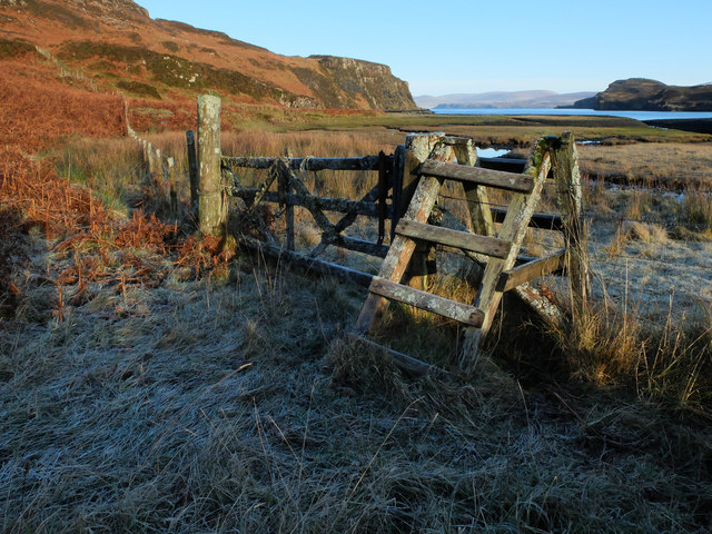
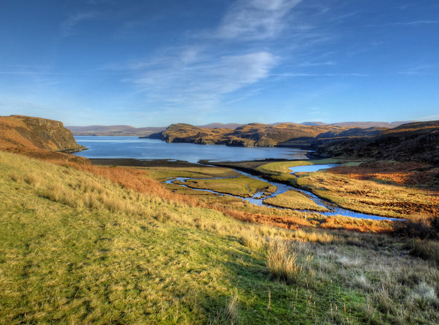
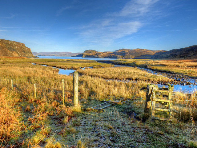
An Ceapanach is characterized by its rugged and rocky terrain, with steep cliffs and rolling hills. The island is covered in grasses, heather, and some scattered trees. Its coastline is indented with small coves and inlets, providing stunning views of the surrounding sea and neighboring islands.

The island is uninhabited and has no permanent structures, making it a haven for wildlife. It is home to a variety of bird species, including puffins, guillemots, and razorbills. Seals can often be spotted lounging on the rocks along the shore.

Access to An Ceapanach is mainly by boat, with some visitors arriving via kayak or small watercraft. The island offers a peaceful and remote escape, ideal for nature lovers and birdwatchers. Hiking and exploring the island's diverse landscape are popular activities, with several walking trails crisscrossing the island.

An Ceapanach is surrounded by pristine waters, making it a popular destination for diving and snorkeling enthusiasts. Underwater, visitors can discover vibrant marine life and explore submerged caves and rock formations.

Overall, An Ceapanach is a picturesque and tranquil island that offers a unique opportunity to experience the beauty of Scotland's coastal wilderness.

If you have any feedback on the listing, please let us know in the comments section below.

An Ceapanach Images

Images are sourced within 2km of 57.506572/-6.465227 or Grid Reference NG3255. Thanks to Geograph Open Source API. All images are credited.
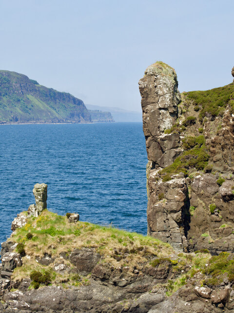
Boc na Caillich—“The old woman’s pimple” First stop after the day’s exertions was to the Ordnance Survey’s website, which has a lovely little page detailing the Gaelic origins of place names. ‘Boc’ turns out to be a buck or a ‘he-goat,’ likely referring to a billy goat. Therefore, Boc na Caillich, I suppose, can be interpreted as ‘the old woman’s billy goat.’

But …

The Scottish Government’s website ScotlandsPlaces has scans of the original surveyors’ notebooks used by the Ordnance Survey. For Boc na Caillich, the surveyor had written:—

<<This name applies to a Small Standing rock, and Signifies “The old woman’s pimple”:, Situated about 3/4 of a mile from “Dunbeg”>>

Mulling this over, it amuses me to entertain the notion that those mischievous Dunbeg crofters were having a jolly good laugh at the befuddlement of those Government officials. I can just picture their impish grins as they spun a yarn, convincingly claiming that "Boc na Caillich" actually pertains to a completely different region of a woman's anatomy altogether. And as for that hilariously prim and proper Victorian surveying brigade, it's no wonder they rendered it as "Pimple" in their records, utterly scandalised by the mere thought of anything remotely risque. Oh, the prudishness of those bygone days!

Adapted from my blog post <span class="nowrap"><a title="http://www.fhithich.uk/?p=32333" rel="nofollow ugc noopener" href="http://www.fhithich.uk/?p=32333">Link</a><img style="margin-left:2px;" alt="External link" title="External link - shift click to open in new window" src="https://s1.geograph.org.uk/img/external.png" width="10" height="10"/></span> which contains relevant sources.
Boc na Caillich—“The old woman’s pimple”
First stop after the day’s exertions was to the Ordnance Survey’s website, which has a lovely little page detailing the Gaelic origins of place names. ‘Boc’ turns out to be a buck or a ‘he-goat,’ likely referring to a billy goat. Therefore, Boc na Caillich, I suppose, can be interpreted as ‘the old woman’s billy goat.’ But … The Scottish Government’s website ScotlandsPlaces has scans of the original surveyors’ notebooks used by the Ordnance Survey. For Boc na Caillich, the surveyor had written:— <<This name applies to a Small Standing rock, and Signifies “The old woman’s pimple”:, Situated about 3/4 of a mile from “Dunbeg”>> Mulling this over, it amuses me to entertain the notion that those mischievous Dunbeg crofters were having a jolly good laugh at the befuddlement of those Government officials. I can just picture their impish grins as they spun a yarn, convincingly claiming that "Boc na Caillich" actually pertains to a completely different region of a woman's anatomy altogether. And as for that hilariously prim and proper Victorian surveying brigade, it's no wonder they rendered it as "Pimple" in their records, utterly scandalised by the mere thought of anything remotely risque. Oh, the prudishness of those bygone days! Adapted from my blog post LinkExternal link which contains relevant sources.
Stacdachan The Victorian surveyor&amp;#039;s notebook contains the following notes:

&amp;lt;&amp;lt;This name spplies to a high Standing rock, Signifying &amp;quot;The Pinnacle&amp;quot; Situated on the Coast 3/4 of a mile north west from Greshornish House.&amp;gt;&amp;gt;

Source: ‘OS1/16/7/111 | ScotlandsPlaces’. 2019. Scotlandsplaces.gov.uk &amp;lt;&lt;span class=&quot;nowrap&quot;&gt;&lt;a title=&quot;https://scotlandsplaces.gov.uk/digital-volumes/ordnance-survey-name-books/inverness-shire-os-name-books-1876-1878/inverness-shire-skye-volume-07/111&quot; rel=&quot;nofollow ugc noopener&quot; href=&quot;https://scotlandsplaces.gov.uk/digital-volumes/ordnance-survey-name-books/inverness-shire-os-name-books-1876-1878/inverness-shire-skye-volume-07/111&quot;&gt;Link&lt;/a&gt;&lt;img style=&quot;margin-left:2px;&quot; alt=&quot;External link&quot; title=&quot;External link - shift click to open in new window&quot; src=&quot;https://s1.geograph.org.uk/img/external.png&quot; width=&quot;10&quot; height=&quot;10&quot;/&gt;&lt;/span&gt; &amp;gt; [accessed 17 July 2023]
Stacdachan
The Victorian surveyor's notebook contains the following notes: <<This name spplies to a high Standing rock, Signifying "The Pinnacle" Situated on the Coast 3/4 of a mile north west from Greshornish House.>> Source: ‘OS1/16/7/111 | ScotlandsPlaces’. 2019. Scotlandsplaces.gov.uk <LinkExternal link > [accessed 17 July 2023]
OS Bolt on the summit of Maol na h-Àirde I&amp;#039;ve been on this summit many times without noticing the bolt. It is a fourth order trig point, set in concrete close to the small cairn, and somewhat overgrown by grass. See &lt;a title=&quot;https://www.geograph.org.uk/photo/2870990&quot; href=&quot;https://www.geograph.org.uk/photo/2870990&quot;&gt;Link&lt;/a&gt; for context.
OS Bolt on the summit of Maol na h-Àirde
I've been on this summit many times without noticing the bolt. It is a fourth order trig point, set in concrete close to the small cairn, and somewhat overgrown by grass. See Link for context.
Ruin at Diubaig The most complete of several ruined houses in the long uninhabited village of Diubaig.
The view is across Loch Diubaig to the peninsula of Greshornish.
Ruin at Diubaig
The most complete of several ruined houses in the long uninhabited village of Diubaig. The view is across Loch Diubaig to the peninsula of Greshornish.
Loch Diubaig The sea loch, an inlet of Loch Snizort, seen from the site of the derelict village of Diubaig.
Loch Diubaig
The sea loch, an inlet of Loch Snizort, seen from the site of the derelict village of Diubaig.
Gate and stile, Diubaig Covered with lichens and, today, with frost. The gate is beyond use without risking terminal damage to it, but the stile still bears weight.
Gate and stile, Diubaig
Covered with lichens and, today, with frost. The gate is beyond use without risking terminal damage to it, but the stile still bears weight.
Track entering the south of Waternish Forest This is a section of a newly constructed track joining the former end of the track in Greshornish Forest &lt;a href=&quot;https://www.geograph.org.uk/photo/1712786&quot;&gt;NG3054 : End of the track&lt;/a&gt; with the former end of the track in Waternish Forest &lt;a href=&quot;https://www.geograph.org.uk/photo/1539433&quot;&gt;NG2957 : End of the track&lt;/a&gt;. It was built to allow timber extraction from Waternish to be taken south to join the public road on the A850 rather than use the single track B886.
Track entering the south of Waternish Forest
This is a section of a newly constructed track joining the former end of the track in Greshornish Forest NG3054 : End of the track with the former end of the track in Waternish Forest NG2957 : End of the track. It was built to allow timber extraction from Waternish to be taken south to join the public road on the A850 rather than use the single track B886.
Loch Diubaig from the old settlement A view from beside the ruins of the old settlement of Diubaig, looking over the outflow of the Allt Diubaig and Loch Diubaig towards the outer reaches of Loch Snizort. The lumpy ground to the right of the loch is Greshornish Point.
Loch Diubaig from the old settlement
A view from beside the ruins of the old settlement of Diubaig, looking over the outflow of the Allt Diubaig and Loch Diubaig towards the outer reaches of Loch Snizort. The lumpy ground to the right of the loch is Greshornish Point.
Gate by the distributaries of the Allt Diubaig The very attractive old lichen covered wooden gate &lt;a href=&quot;https://www.geograph.org.uk/photo/4787214&quot;&gt;NG3254 : Gate and stile, Diubaig&lt;/a&gt; is fallen and broken. Sad to see it gone. The stile is now redundant, so may last a bit longer.
The view over the distributaries is to Loch Diubaig, where the river reaches the sea.
Gate by the distributaries of the Allt Diubaig
The very attractive old lichen covered wooden gate NG3254 : Gate and stile, Diubaig is fallen and broken. Sad to see it gone. The stile is now redundant, so may last a bit longer. The view over the distributaries is to Loch Diubaig, where the river reaches the sea.
Bay on the east side of Loch Diubaig
New track above Diubaig The road is under construction and at present terminates nowhere special in the woods. I presume it will run to the old settlement in Diubaig &lt;a href=&quot;https://www.geograph.org.uk/photo/172785&quot;&gt;NG3254 : Houses at Diubaig&lt;/a&gt; where planning consent is being sought for development.
New track above Diubaig
The road is under construction and at present terminates nowhere special in the woods. I presume it will run to the old settlement in Diubaig NG3254 : Houses at Diubaig where planning consent is being sought for development.
Track to Lòn na Stapaig The track ends at a boathouse.
Track to Lòn na Stapaig
The track ends at a boathouse.
Redwood House, Greshornish Large modern hotel in an enviable remote location overlooking Loch Greshornish. 
Also photographed by John Allan in 2010 when under construction - &lt;a href=&quot;https://www.geograph.org.uk/photo/1767732&quot;&gt;NG3453 : New build at Greshornish&lt;/a&gt;.
Redwood House, Greshornish
Large modern hotel in an enviable remote location overlooking Loch Greshornish. Also photographed by John Allan in 2010 when under construction - NG3453 : New build at Greshornish.
Pontoon, Loch Greshornish, Isle of Skye Looking NE over the Loch greshornish to Trotternish and its famous ridge.  This part of the loch is fish farmed, hence the foreground ropes, pontoon, buoys and boats.
Pontoon, Loch Greshornish, Isle of Skye
Looking NE over the Loch greshornish to Trotternish and its famous ridge. This part of the loch is fish farmed, hence the foreground ropes, pontoon, buoys and boats.
Track towards Diubaig A good track leads from near the Gresnornish House hotel, across the peninsulato Loch Diubaig. This would have been the main access to the now deserted settlement at the head of the loch.
Track towards Diubaig
A good track leads from near the Gresnornish House hotel, across the peninsulato Loch Diubaig. This would have been the main access to the now deserted settlement at the head of the loch.
The head of Loch Diubaig An inlet from Loch Snizort. Beyond the rocky foreshore is a small freshwater lochan and the deserted settlement of Diubaig, occupied until the early twentieth century.
The head of Loch Diubaig
An inlet from Loch Snizort. Beyond the rocky foreshore is a small freshwater lochan and the deserted settlement of Diubaig, occupied until the early twentieth century.
Rocky beach at Diubaig Looking along the north west side of the Greshornish peninsula.
Rocky beach at Diubaig
Looking along the north west side of the Greshornish peninsula.
Seaweed on the rocky foreshore, Diubaig
Show me another place!

An Ceapanach is located at Grid Ref: NG3255 (Lat: 57.506572, Lng: -6.465227)

Unitary Authority: Highland

Police Authority: Highlands and Islands

What 3 Words

///reassured.songbird.formation. Near Dunvegan, Highland

Nearby Locations

An Ceapanach

Related Wikis

Flashader

Flashader (Scottish Gaelic: Flaiseader) is a small crofting township close to the east coast of the sea loch Loch Greshornish on the Isle of Skye. It is...

A850 road

The A850 road is a road in the Scottish Isles, off the west coast of mainland Scotland. == Road function == It is one of the principal roads of the Isle...

Edinbane

Edinbane (Scottish Gaelic: An t-Aodann Bàn the fair hill-face) is a small village on the island of Skye, Scotland. == Location == Edinbane lies on the...

Suladale

Suladale or Suledale (Scottish Gaelic: Sùladal) is a small mixed crofting hamlet of fewer than a dozen houses, located near Edinbane, on the north of...

Nearby Amenities

Located within 500m of 57.506572,-6.465227
Created By: dmgroom_coastlines
Source: PGS
Lat/Long: 57.50235/-6.46237
Created By: dmgroom_coastlines
Source: PGS
Lat/Long: 57.50285/-6.46186
Created By: dmgroom_coastlines
Source: PGS
Lat/Long: 57.50298/-6.46161
Created By: dmgroom_coastlines
Source: PGS
Lat/Long: 57.5031/-6.46137
Source: PGS
Lat/Long: 57.5034931/-6.4612628
Created By: dmgroom_coastlines
Source: PGS
Lat/Long: 57.50398/-6.46059
Source: PGS
Lat/Long: 57.504018/-6.4612121
Created By: dmgroom_coastlines
Source: PGS
Lat/Long: 57.50425/-6.46152
Created By: dmgroom_coastlines
Source: PGS
Lat/Long: 57.50414/-6.46201
Source: PGS
Lat/Long: 57.5045867/-6.4630108
Source: PGS
Lat/Long: 57.5048524/-6.4634448
Source: PGS
Lat/Long: 57.5052358/-6.4637296
Source: PGS
Lat/Long: 57.5054419/-6.4638781
Source: PGS
Lat/Long: 57.5055681/-6.4649469
Source: PGS
Lat/Long: 57.5060915/-6.4648784
Source: PGS
Lat/Long: 57.5067888/-6.465156
Source: PGS
Lat/Long: 57.5066957/-6.4655402
Source: PGS
Lat/Long: 57.5068823/-6.4659326
Created By: dmgroom_coastlines
Source: PGS
Lat/Long: 57.5073/-6.46654
Source: PGS
Lat/Long: 57.50783/-6.46746
Source: PGS
Lat/Long: 57.5082888/-6.4676393
Source: PGS
Lat/Long: 57.5090032/-6.4685084
Source: PGS
Lat/Long: 57.5094944/-6.4692059
Source: PGS
Lat/Long: 57.5098408/-6.4692268
Source: PGS
Lat/Long: 57.5100663/-6.4693992
Source: PGS
Lat/Long: 57.510322/-6.4696903
The data included in this document is from www.openstreetmap.org. The data is made available under ODbL.

Have you been to An Ceapanach?

Leave your review of An Ceapanach below (or comments, questions and feedback).