Sgeir Thindealan

Island in Ross-shire

Scotland

Sgeir Thindealan

Telephone Box at Crulabhig Probably it's only the sheep that get calls here?
Telephone Box at Crulabhig Credit: Jo and Steve Turner

Sgeir Thindealan is a small island located off the coast of Ross-shire, Scotland. Situated in the North Atlantic Ocean, it is part of the Inner Hebrides archipelago. The island is approximately 1.5 miles long and half a mile wide, with an area of around 300 acres.

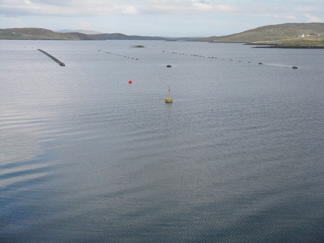
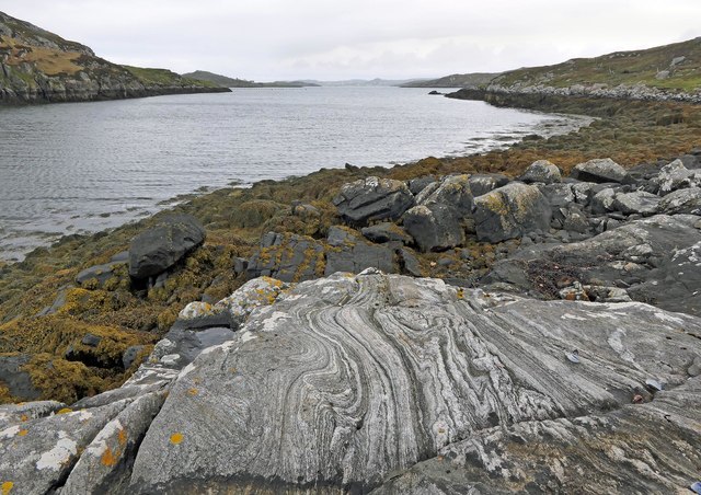
Sgeir Thindealan is characterized by its rugged and rocky terrain. The island is largely uninhabited and lacks any permanent structures or amenities. Its coastline is composed of steep cliffs, providing a habitat for various seabirds, including gannets, puffins, and guillemots. The surrounding waters are known for their rich marine life, attracting seals and dolphins.

Access to Sgeir Thindealan is challenging due to its remote location and lack of transportation infrastructure. The island is only accessible by boat, and visitors must be cautious of the strong currents and unpredictable weather conditions in the area.

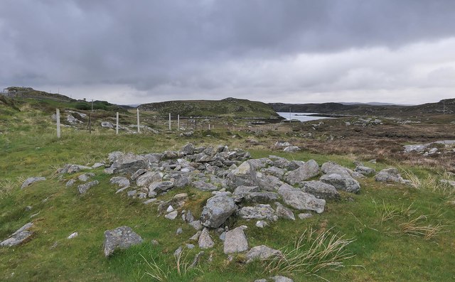
Despite its limited human presence, Sgeir Thindealan holds historical significance. It is believed to have been used as a hunting ground by ancient civilizations, with archaeological remains suggesting human activity dating back thousands of years.

Today, Sgeir Thindealan remains a destination sought by nature enthusiasts, birdwatchers, and those seeking a remote and untouched landscape. Its isolation and untouched beauty make it an attractive location for those who appreciate the raw and untamed nature of the Scottish coast.

If you have any feedback on the listing, please let us know in the comments section below.

Sgeir Thindealan Images

Images are sourced within 2km of 58.199079/-6.7937832 or Grid Reference NB1833. Thanks to Geograph Open Source API. All images are credited.

Telephone Box at Crulabhig Probably it's only the sheep that get calls here?
Telephone Box at Crulabhig
Probably it's only the sheep that get calls here?
Crulivig: the telephone box Pictured during heavy rain, this phone box has Hebridean doors, to keep the wind at bay.
Crulivig: the telephone box
Pictured during heavy rain, this phone box has Hebridean doors, to keep the wind at bay.
Crulivig: postbox № HS2 91 This postbox stands on the opposite side of the road to <a href="https://www.geograph.org.uk/photo/3286743">NB1733 : Crulivig: the telephone box</a>. It is emptied each morning except Sunday at a quarter to nine.
Crulivig: postbox № HS2 91
This postbox stands on the opposite side of the road to NB1733 : Crulivig: the telephone box. It is emptied each morning except Sunday at a quarter to nine.
Abandoned croft house near Lundal
A view over Loch Barraglom From Iarsiadar.
A view over Loch Barraglom
From Iarsiadar.
Mussel farm at Iarsiadar To the east of the Bernara Bridge between Great Bernera/Beàrnaraigh and the Isle of Lewis.
Mussel farm at Iarsiadar
To the east of the Bernara Bridge between Great Bernera/Beàrnaraigh and the Isle of Lewis.
Low cloud over Great Bernera A thin bank of cloud over the sea. Looking northeast from the B8059 near Lundale.
Low cloud over Great Bernera
A thin bank of cloud over the sea. Looking northeast from the B8059 near Lundale.
Rough pasture near Lundale Looking east towards Callanish, across Loch Ròg.
Rough pasture near Lundale
Looking east towards Callanish, across Loch Ròg.
Beinn Scarastaigh from near Lundale A large rocky hill about 1km to the southeast,
Beinn Scarastaigh from near Lundale
A large rocky hill about 1km to the southeast,
Croftland, Circebost, Great Bernera Looking across Loch Ròg an Ear (East Loch Roag) towards Eilean Chearstaigh.
Croftland, Circebost, Great Bernera
Looking across Loch Ròg an Ear (East Loch Roag) towards Eilean Chearstaigh.
Calanais/Callanish XV, Circebost, Great Bernera/Beàrnaraigh From Discovery and Excavation in Scotland, 1976: "On grassy ridge 100m N of road, 25m E of track through Croft 24, Kirkibost. A large prone slab approx. 3.55m x 1.35m, thickness varying from 0.25-0.45m, lying in peat on a grassy ridge. The lower end appears to be surrounded by packing stones and there is a void under the centre of the stone. This stone was brought to our notice by Mr Norman MacDonald of Kirkibost."
Calanais/Callanish XV, Circebost, Great Bernera/Beàrnaraigh
From Discovery and Excavation in Scotland, 1976: "On grassy ridge 100m N of road, 25m E of track through Croft 24, Kirkibost. A large prone slab approx. 3.55m x 1.35m, thickness varying from 0.25-0.45m, lying in peat on a grassy ridge. The lower end appears to be surrounded by packing stones and there is a void under the centre of the stone. This stone was brought to our notice by Mr Norman MacDonald of Kirkibost."
Possible fallen standing stone, Circebost, Great Bernera/Beàrnaraigh This stone lies approximately 80m ESE of <a href="https://www.geograph.org.uk/photo/5293759">NB1734 : Calanais/Callanish XV, Circebost, Great Bernera/Beàrnaraigh</a>.  The croft owner, who is the grandson of Norman MacDonald who originally brought Callanish XV to archaeologists' attention, believes it to be fallen standing stone.
Possible fallen standing stone, Circebost, Great Bernera/Beàrnaraigh
This stone lies approximately 80m ESE of NB1734 : Calanais/Callanish XV, Circebost, Great Bernera/Beàrnaraigh. The croft owner, who is the grandson of Norman MacDonald who originally brought Callanish XV to archaeologists' attention, believes it to be fallen standing stone.
Looking down at Circebost Circebost or Kirkibost is a tiny settlement on Great Bernera. This island is now connected to Lewis by a short pre-stressed concrete bridge. In 1953 when it was built it was and remains the first bridge of such material in Europe.  

The settlemenr is also important as it is the first planned crofting township in the Outer Hebrides, though I think town is a lofty description for such a small group of houses.
Looking down at Circebost
Circebost or Kirkibost is a tiny settlement on Great Bernera. This island is now connected to Lewis by a short pre-stressed concrete bridge. In 1953 when it was built it was and remains the first bridge of such material in Europe. The settlemenr is also important as it is the first planned crofting township in the Outer Hebrides, though I think town is a lofty description for such a small group of houses.
Tòb Lundale, Isle of Lewis Tòb Lundale is an inlet on Loch Ròg.  Tòb is a Gaelic word for bay or cove.
Tòb Lundale, Isle of Lewis
Tòb Lundale is an inlet on Loch Ròg. Tòb is a Gaelic word for bay or cove.
Building remains, Lundal, Isle of Lewis Looking towards the head of Tòb Lundale, an inlet on Loch Ròg.
Building remains, Lundal, Isle of Lewis
Looking towards the head of Tòb Lundale, an inlet on Loch Ròg.
Phonebox on the road to Great Bernera
Ruined cottage on Great Bernera The ruin stands at the side of the minor road close to the north shore of Loch Barraglom.
Ruined cottage on Great Bernera
The ruin stands at the side of the minor road close to the north shore of Loch Barraglom.
End of the road at Tobhtaral Two houses at the end of the road in the SE corner of Great Bernera island.
End of the road at Tobhtaral
Two houses at the end of the road in the SE corner of Great Bernera island.
Show me another place!

Sgeir Thindealan is located at Grid Ref: NB1833 (Lat: 58.199079, Lng: -6.7937832)

Unitary Authority: Na h-Eileanan an Iar

Police Authority: Highlands and Islands

What 3 Words

///swipes.severe.aced. Near Carloway, Na h-Eileanan Siar

Related Wikis

Eilean Chearstaidh

Eilean Kearstay (Scottish Gaelic: Eilean Chearstaigh) is an uninhabited island in Loch Roag in the Outer Hebrides of Scotland. It lies south east of Great...

Ceabhaigh

Ceabhaigh is a small island in an arm of Loch Ròg on the west coast of Lewis in the Outer Hebrides of Scotland. It is about 25 hectares (62 acres) in extent...

Callanish VIII

The Callanish VIII stone setting is one of many megalithic structures around the better-known (and larger) Calanais I on the west coast of the Isle of...

Callanish Stones

The Callanish Stones (or "Callanish I": Scottish Gaelic: Clachan Chalanais or Tursachan Chalanais) are an arrangement of standing stones placed in a cruciform...

Nearby Amenities

Located within 500m of 58.199079,-6.7937832
Power: pole
Lat/Long: 58.1957857/-6.7945517
Power: pole
Lat/Long: 58.195254/-6.7942831
The data included in this document is from www.openstreetmap.org. The data is made available under ODbL.

Have you been to Sgeir Thindealan?

Leave your review of Sgeir Thindealan below (or comments, questions and feedback).