Stac a' Chàis

Island in Ross-shire

Scotland

Stac a' Chàis

Mangurstadh Coastline Looking South The cliffs here are spectacular and the Lewisian Gneiss makes for some great climbing.
Mangurstadh Coastline Looking South Credit: RIJones

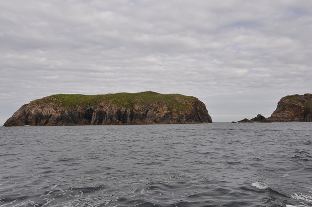
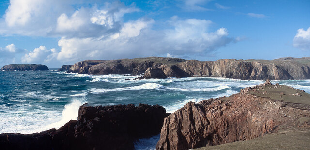
Stac a' Chàis is a small uninhabited island located off the coast of Ross-shire, in the Scottish Highlands. With an area of less than 1 acre, it is one of the smallest islands in the region. The island is situated in the Inner Sound, between the mainland and the Isle of Skye, making it easily accessible by boat.

The name "Stac a' Chàis" translates to "stack of the cheese" in English, although the origin of this name is not entirely clear. The island is known for its distinctive geological feature, a tall sea stack that rises dramatically from the surrounding waters. This natural column of rock, formed by erosion over millions of years, creates a striking sight against the backdrop of the sea and sky.

Due to its small size and lack of amenities, Stac a' Chàis does not support any permanent human population. However, the island is a popular destination for birdwatchers and wildlife enthusiasts. It serves as a nesting site for various seabirds, including fulmars, guillemots, and razorbills. The surrounding waters are also home to seals and dolphins, providing ample opportunities for marine wildlife sightings.

Visitors to Stac a' Chàis can explore the island and its rugged coastline, but caution is advised due to the steep cliffs and unpredictable tides. The island offers a peaceful and remote environment, making it a perfect spot for nature lovers seeking solitude and natural beauty.

If you have any feedback on the listing, please let us know in the comments section below.

Stac a' Chàis Images

Images are sourced within 2km of 58.165777/-7.0953521 or Grid Reference NB0030. Thanks to Geograph Open Source API. All images are credited.

Mangurstadh Coastline Looking South The cliffs here are spectacular and the Lewisian Gneiss makes for some great climbing.
Mangurstadh Coastline Looking South
The cliffs here are spectacular and the Lewisian Gneiss makes for some great climbing.
Eilean Molach Showing the narrow gap between it and mainland Lewis.
Eilean Molach
Showing the narrow gap between it and mainland Lewis.
Road, Peat Cuttings and Moorland
Geodh' an Fhithich Sea Stacks
A pretty lochan This is Lochan Mealabhat, two thirds of which is in this square. It is a pleasing geograph photo, because it clearly shows what you can see on the map: I'm standing on a little tongue of land that sticks out into the lochan, the tongue is in the square, and I'm looking across to a similar tongue.
A pretty lochan
This is Lochan Mealabhat, two thirds of which is in this square. It is a pleasing geograph photo, because it clearly shows what you can see on the map: I'm standing on a little tongue of land that sticks out into the lochan, the tongue is in the square, and I'm looking across to a similar tongue.
Rubh' an Taroin headland
Rubh' an Taroin
Rubh' an Taroin
Coastal moor at Mullach an Tàroin
North end of Traigh Mhangarstaidh A beautiful beach with a fine Atlantic swell pounding in.
North end of Traigh Mhangarstaidh
A beautiful beach with a fine Atlantic swell pounding in.
Atlantic swell, Traigh Mhangarstaidh An exciting time being beside to a tumultuous sea - and at close range.
Atlantic swell, Traigh Mhangarstaidh
An exciting time being beside to a tumultuous sea - and at close range.
Looking down on Traigh Mhangarstaidh A walk for the view with my son on the beach.
Looking down on Traigh Mhangarstaidh
A walk for the view with my son on the beach.
Sea off Traigh Mhangarstaidh Exhilarating!
Sea off Traigh Mhangarstaidh
Exhilarating!
Coast line near Traigh Mhangarstaidh A wide view from stitching images.  An amazing experience.
Coast line near Traigh Mhangarstaidh
A wide view from stitching images. An amazing experience.
Cairn on Aird Feinis A cairn marks the highest point on the relatively level summit of Aird Feinis, with Aird Mangarstadh in the background.
Cairn on Aird Feinis
A cairn marks the highest point on the relatively level summit of Aird Feinis, with Aird Mangarstadh in the background.
Geodha an Fhithich Several ridges of rock have been eroded to form a series of jagged rock stacks north of Aird Feinis.
Geodha an Fhithich
Several ridges of rock have been eroded to form a series of jagged rock stacks north of Aird Feinis.
Geodha an Fhithich Several ridges of rock have been eroded to form a series of jagged rock stacks north of Aird Feinis.
Geodha an Fhithich
Several ridges of rock have been eroded to form a series of jagged rock stacks north of Aird Feinis.
Geodha an Fhithich The sea north of Aird Feinis is studded with jagged sea stacks formed from granite intruded into the local Lewisian gneiss.
Geodha an Fhithich
The sea north of Aird Feinis is studded with jagged sea stacks formed from granite intruded into the local Lewisian gneiss.
Aird Feinis The vegetation on this patch on the clifftop has been blown clean away by storms. Thrift (Armeria maritima) is recolonising the sand, and will eventually form a new sward.
Aird Feinis
The vegetation on this patch on the clifftop has been blown clean away by storms. Thrift (Armeria maritima) is recolonising the sand, and will eventually form a new sward.
Show me another place!

Stac a' Chàis is located at Grid Ref: NB0030 (Lat: 58.165777, Lng: -7.0953521)

Unitary Authority: Na h-Eileanan an Iar

Police Authority: Highlands and Islands

What 3 Words

///router.call.plod. Near Carloway, Na h-Eileanan Siar

Related Wikis

Stac Dhòmhnaill Chaim

Stac Dhòmnuill Chaim, or Stac Dhòmhnaill Chaim, or Stac Domhnuill Chaim, is a fortified promontory located near Mangursta (or Mangersta, Scottish Gaelic...

Abhainn Dearg distillery

Abhainn Dearg distillery ( AV-in JAIRG) or Red River distillery is a Scotch whisky distillery in Uig, on the west coast of the Isle of Lewis in the Outer...

Gasker

Gasker is a small uninhabited islet in the Outer Hebrides of Scotland, 8 kilometres (4+1⁄2 nautical miles) southwest of Scarp, off the west coast of Harris...

Ardroil

Ardroil (Scottish Gaelic: Eadar Dhà Fhadhail) is a village on the Isle of Lewis in the Outer Hebrides, Scotland. Ardroil is within the parish of Uig....

Uig, Lewis

Uig (Scottish Gaelic: Ùig [uːkʲ]), also known as Sgìr' Ùig, is a civil parish and community in the west of the Isle of Lewis in the Outer Hebrides, Scotland...

Brenish

Brenish (Scottish Gaelic: Brèinis) is a small village situated on the west coast of the Isle of Lewis, which is part of the Outer Hebrides of Scotland...

Timsgarry

Timsgarry (Scottish Gaelic: Tuimisgearraidh) is a village on the Isle of Lewis, in the Outer Hebrides, Scotland. Timsgarry is home to the Baile na Cille...

Camas Uig

Camas Uig (Uig Bay) is a bay on the west coast of the Isle of Lewis, in the Outer Hebrides of Scotland. The Lewis Chessmen were discovered in the dunes...

Nearby Amenities

Located within 500m of 58.165777,-7.0953521
Bus Stop
Mangersta Village
Bus: yes
Naptan AtcoCode: 6010731745
Naptan Bearing: E
Naptan CommonName: Mangersta Village
Naptan Indicator: Mangersta Village
Naptan Landmark: Mangersta Village
Naptan NaptanCode: 94723789
Naptan Street: Mangersta Village
Naptan Verified: no
Shelter: no
Source: naptan_import
Lat/Long: 58.1697704/-7.0918812
Turning Circle
Lat/Long: 58.1697077/-7.0918304
Barrier: cattle_grid
Lat/Long: 58.1698227/-7.0917505
Tourism: attraction
Lat/Long: 58.1693289/-7.0975134
Mangersta Stack
Tourism: viewpoint
Lat/Long: 58.1685717/-7.0952906
Rubha Thisgeis
Natural: cape
Lat/Long: 58.1684265/-7.0993253
Berie Beag
Natural: bay
Lat/Long: 58.1693205/-7.0983544
The data included in this document is from www.openstreetmap.org. The data is made available under ODbL.

Have you been to Stac a' Chàis?

Leave your review of Stac a' Chàis below (or comments, questions and feedback).