Gleann Mòr

Valley in Ross-shire

Scotland

Gleann Mòr

Mangurstadh Coastline Looking South The cliffs here are spectacular and the Lewisian Gneiss makes for some great climbing.
Mangurstadh Coastline Looking South Credit: RIJones

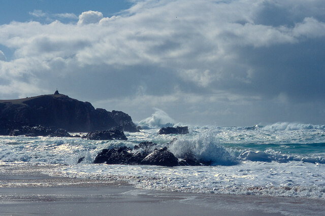
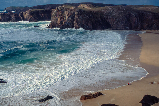
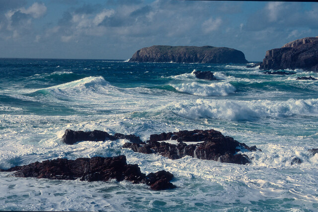
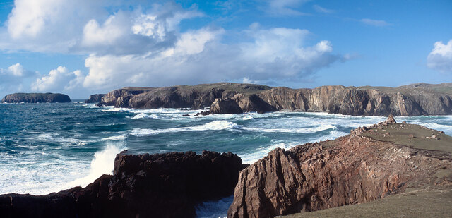
Gleann Mòr, located in Ross-shire, Scotland, is a picturesque valley renowned for its stunning natural beauty and rich historical significance. Spanning approximately 20 miles in length, the valley is nestled amidst the majestic peaks of the Scottish Highlands, providing visitors with breathtaking vistas of rugged mountains, verdant forests, and glistening lochs.

The valley is characterized by its diverse landscape, featuring steep slopes, cascading waterfalls, and meandering rivers. The River Orrin flows through Gleann Mòr, adding to its charm and offering opportunities for fishing and water-based activities. The area is also home to a variety of wildlife, including red deer, golden eagles, and otters, making it a haven for nature enthusiasts and wildlife lovers.

Gleann Mòr holds great historical significance as well, with numerous archaeological sites dotting the landscape. Ruins of ancient settlements and standing stones serve as reminders of the valley's rich heritage. Additionally, remnants of old crofts and traditional Highland cottages can still be found, providing a glimpse into the area's rural past.

For outdoor enthusiasts, Gleann Mòr offers a plethora of activities to enjoy. Hiking and mountain biking trails crisscross the valley, allowing adventurers to explore its hidden gems. The valley also offers opportunities for camping, picnicking, and photography, ensuring that visitors can immerse themselves in its natural beauty.

With its breathtaking scenery, abundant wildlife, and historical significance, Gleann Mòr in Ross-shire is a destination that captivates the hearts of all who visit, offering an unforgettable experience amidst the splendor of the Scottish Highlands.

If you have any feedback on the listing, please let us know in the comments section below.

Gleann Mòr Images

Images are sourced within 2km of 58.164267/-7.0863166 or Grid Reference NB0030. Thanks to Geograph Open Source API. All images are credited.

Mangurstadh Coastline Looking South The cliffs here are spectacular and the Lewisian Gneiss makes for some great climbing.
Mangurstadh Coastline Looking South
The cliffs here are spectacular and the Lewisian Gneiss makes for some great climbing.
Road, Peat Cuttings and Moorland
A pretty lochan This is Lochan Mealabhat, two thirds of which is in this square. It is a pleasing geograph photo, because it clearly shows what you can see on the map: I'm standing on a little tongue of land that sticks out into the lochan, the tongue is in the square, and I'm looking across to a similar tongue.
A pretty lochan
This is Lochan Mealabhat, two thirds of which is in this square. It is a pleasing geograph photo, because it clearly shows what you can see on the map: I'm standing on a little tongue of land that sticks out into the lochan, the tongue is in the square, and I'm looking across to a similar tongue.
Rubh' an Taroin headland
Rubh' an Taroin
Rubh' an Taroin
Coastal moor at Mullach an Tàroin
North end of Traigh Mhangarstaidh A beautiful beach with a fine Atlantic swell pounding in.
North end of Traigh Mhangarstaidh
A beautiful beach with a fine Atlantic swell pounding in.
Atlantic swell, Traigh Mhangarstaidh An exciting time being beside to a tumultuous sea - and at close range.
Atlantic swell, Traigh Mhangarstaidh
An exciting time being beside to a tumultuous sea - and at close range.
Looking down on Traigh Mhangarstaidh A walk for the view with my son on the beach.
Looking down on Traigh Mhangarstaidh
A walk for the view with my son on the beach.
Sea off Traigh Mhangarstaidh Exhilarating!
Sea off Traigh Mhangarstaidh
Exhilarating!
Coast line near Traigh Mhangarstaidh A wide view from stitching images.  An amazing experience.
Coast line near Traigh Mhangarstaidh
A wide view from stitching images. An amazing experience.
Geodha an Fhithich Several ridges of rock have been eroded to form a series of jagged rock stacks north of Aird Feinis.
Geodha an Fhithich
Several ridges of rock have been eroded to form a series of jagged rock stacks north of Aird Feinis.
Geodha an Fhithich Several ridges of rock have been eroded to form a series of jagged rock stacks north of Aird Feinis.
Geodha an Fhithich
Several ridges of rock have been eroded to form a series of jagged rock stacks north of Aird Feinis.
Geodha an Fhithich The sea north of Aird Feinis is studded with jagged sea stacks formed from granite intruded into the local Lewisian gneiss.
Geodha an Fhithich
The sea north of Aird Feinis is studded with jagged sea stacks formed from granite intruded into the local Lewisian gneiss.
Aird Feinis
Aird Feinis
Rock strewn landscape north of Islibhig Looking across Druim Raois towards Mealaisbhal.
Rock strewn landscape north of Islibhig
Looking across Druim Raois towards Mealaisbhal.
Geodha an Fhithich I spotted this on the map and I just had to visit it. Fhithich, as some of my regular readers will know is the domain name for this blog. It’s Gaelic for raven. Geodha means a chasm or ravine. So this is the ravine of the raven. I must admit I was a bit disappointed. I’ve seen geodha before which have much more vertical sides but the sea stacks in the bay across to the headland Àird Feinis were spectacular.

From my blog <span class="nowrap"><a title="https://fhithich.wordpress.com/2017/08/23/geodha-an-fhithich/" rel="nofollow ugc noopener" href="https://fhithich.wordpress.com/2017/08/23/geodha-an-fhithich/">Link</a><img style="margin-left:2px;" alt="External link" title="External link - shift click to open in new window" src="https://s1.geograph.org.uk/img/external.png" width="10" height="10"/></span>
Geodha an Fhithich
I spotted this on the map and I just had to visit it. Fhithich, as some of my regular readers will know is the domain name for this blog. It’s Gaelic for raven. Geodha means a chasm or ravine. So this is the ravine of the raven. I must admit I was a bit disappointed. I’ve seen geodha before which have much more vertical sides but the sea stacks in the bay across to the headland Àird Feinis were spectacular. From my blog LinkExternal link
Tom Raois The peak is Mealaisbhal <a href="https://www.geograph.org.uk/gridref/NB0227">NB0227</a>.
Tom Raois
The peak is Mealaisbhal NB0227.
Show me another place!

Gleann Mòr is located at Grid Ref: NB0030 (Lat: 58.164267, Lng: -7.0863166)

Unitary Authority: Na h-Eileanan an Iar

Police Authority: Highlands and Islands

What 3 Words

///defected.topic.command. Near Carloway, Na h-Eileanan Siar

Related Wikis

Stac Dhòmhnaill Chaim

Stac Dhòmnuill Chaim, or Stac Dhòmhnaill Chaim, or Stac Domhnuill Chaim, is a fortified promontory located near Mangursta (or Mangersta, Scottish Gaelic...

Abhainn Dearg distillery

Abhainn Dearg distillery ( AV-in JAIRG) or Red River distillery is a Scotch whisky distillery in Uig, on the west coast of the Isle of Lewis in the Outer...

Gasker

Gasker is a small uninhabited islet in the Outer Hebrides of Scotland, 8 kilometres (4+1⁄2 nautical miles) southwest of Scarp, off the west coast of Harris...

Ardroil

Ardroil (Scottish Gaelic: Eadar Dhà Fhadhail) is a village on the Isle of Lewis in the Outer Hebrides, Scotland. Ardroil is within the parish of Uig....

Uig, Lewis

Uig (Scottish Gaelic: Ùig [uːkʲ]), also known as Sgìr' Ùig, is a civil parish and community in the west of the Isle of Lewis in the Outer Hebrides, Scotland...

Brenish

Brenish (Scottish Gaelic: Brèinis) is a small village situated on the west coast of the Isle of Lewis, which is part of the Outer Hebrides of Scotland...

Timsgarry

Timsgarry (Scottish Gaelic: Tuimisgearraidh) is a village on the Isle of Lewis, in the Outer Hebrides, Scotland. Timsgarry is home to the Baile na Cille...

Camas Uig

Camas Uig (Uig Bay) is a bay on the west coast of the Isle of Lewis, in the Outer Hebrides of Scotland. The Lewis Chessmen were discovered in the dunes...

Nearby Amenities

Located within 500m of 58.164267,-7.0863166
Passing Place
Lat/Long: 58.1647689/-7.0794823
Passing Place
Lat/Long: 58.1641564/-7.0818999
Passing Place
Lat/Long: 58.165249/-7.0781046
Passing Place
Lat/Long: 58.1636979/-7.0837579
Passing Place
Lat/Long: 58.1631024/-7.0847756
Passing Place
Lat/Long: 58.1621781/-7.0852785
Power: pole
Lat/Long: 58.1647395/-7.0786507
Power: pole
Lat/Long: 58.1644766/-7.0796087
Power: pole
Lat/Long: 58.1641645/-7.0807333
Power: pole
Lat/Long: 58.1639126/-7.0817061
Power: pole
Lat/Long: 58.1635833/-7.0826987
Power: pole
Lat/Long: 58.1628371/-7.0832946
Power: pole
Lat/Long: 58.1621147/-7.0838933
Power: pole
Lat/Long: 58.1613775/-7.084504
Power: pole
Lat/Long: 58.1607587/-7.0849908
Power: pole
Lat/Long: 58.1599524/-7.085649
The data included in this document is from www.openstreetmap.org. The data is made available under ODbL.

Have you been to Gleann Mòr?

Leave your review of Gleann Mòr below (or comments, questions and feedback).