Eilean Biorach Meadhoin
Island in Inverness-shire
Scotland
Eilean Biorach Meadhoin

Eilean Biorach Meadhoin is a small island located in the county of Inverness-shire in Scotland. Situated within the picturesque Scottish Highlands, this island is a hidden gem known for its natural beauty and historic significance.
Covering an area of approximately 10 acres, Eilean Biorach Meadhoin is surrounded by the tranquil waters of Loch Meadhoin. The island is characterized by its rugged landscape, with rocky cliffs and lush green vegetation. It is home to a diverse range of wildlife, including seabirds, otters, and various species of fish.
One of the notable features of Eilean Biorach Meadhoin is its ancient ruins. The island boasts the remains of a medieval castle, which once served as a defensive stronghold. The castle's crumbling walls and moss-covered stones offer a glimpse into its rich history and the turbulent times it has witnessed.
Access to the island is limited, as it is only reachable by boat or kayak. This adds to its secluded and untouched atmosphere, making it a favorite destination for those seeking solitude and tranquility. Visitors can explore the island's rugged terrain, take in the breathtaking views of the surrounding loch and mountains, and immerse themselves in the serenity of nature.
Eilean Biorach Meadhoin is a place of natural beauty, historical significance, and peacefulness. It allows visitors to escape the hustle and bustle of everyday life and connect with the stunning landscape of the Scottish Highlands.
If you have any feedback on the listing, please let us know in the comments section below.
Eilean Biorach Meadhoin Images
Images are sourced within 2km of 57.526081/-7.3258563 or Grid Reference NF8160. Thanks to Geograph Open Source API. All images are credited.


Eilean Biorach Meadhoin is located at Grid Ref: NF8160 (Lat: 57.526081, Lng: -7.3258563)
Unitary Authority: Na h-Eileanan an Iar
Police Authority: Highlands and Islands
What 3 Words
///bumpy.forwarded.private. Near Balivanich, Na h-Eileanan Siar
Nearby Locations
Related Wikis

Battle of Carinish
The Battle of Carinish was a Scottish clan battle fought in North Uist in 1601. It was part of a year of feuding between Clan MacLeod of Dunvegan and the...

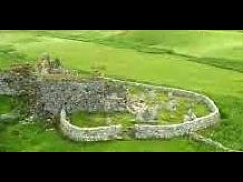
Teampull na Trionaid
Teampull na Trionaid ("trinity church") is a ruined 13th-century Augustinian nunnery at Carinish, on North Uist, in the Outer Hebrides of Scotland. �...

Carinish
Carinish (Scottish Gaelic: Càirinis), is a hamlet on North Uist, in the Outer Hebrides, Scotland. It is in the south of the island, about two miles (three...

Bail' Iochdrach
Bail' Iochdrach or Baliochrach (Scottish Gaelic: Am Baile Ìochdrach) is a village on Benbecula in the Outer Hebrides, Scotland. Baliochrach is within the...
Related Videos
Trinity Temple On Visit To Carinish Island Of North Uist Outer Hebrides Scotland
Tour Scotland travel video clip, with Scottish music, of Trinity Temple on visit to Carinish on the Island of North Uist in the Outer ...
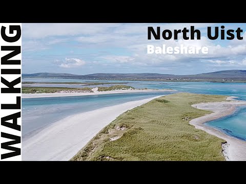
A walk round, Baleshare - North Uist - Scotland
This was our first walk, whilst on staycation in North Uist. This is a figure of 8 walk round the island of Baleshare. You can look at ...

Teampull na Trionaid With Music On Visit To Carinish Island Of North Uist Outer Hebrides Scotland
Tour Scotland 4K travel video, with Scottish music, of Trinity Temple on ancestry, genealogy, family history visit to Carinish on the ...

Helping out a sheep caught up in wire.
We were out walking in South Baleshare, when we came across a sheep, caught in wire. Not one for walking by, I helped the wee ...
Nearby Amenities
Located within 500m of 57.526081,-7.3258563Have you been to Eilean Biorach Meadhoin?
Leave your review of Eilean Biorach Meadhoin below (or comments, questions and feedback).