Corrie of Braeminzion

Corrie (Glacial Valley) in Angus

Scotland

Corrie of Braeminzion

View through the bridge Picture taken while standing on a rock in the river, at very low water level.
View through the bridge Credit: Aleks Scholz

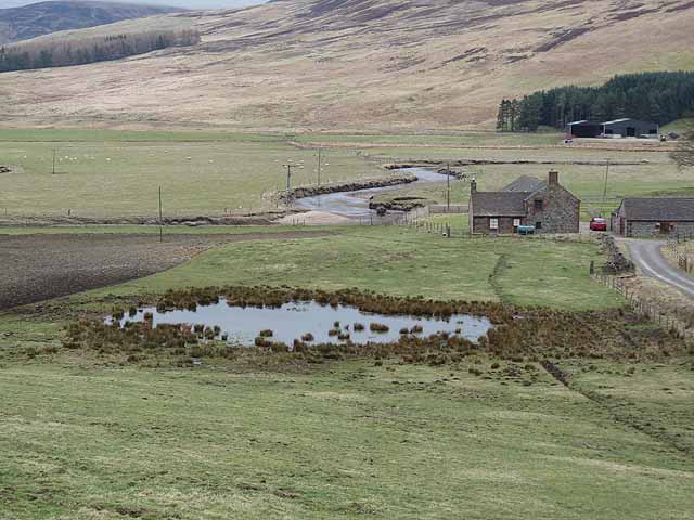
Corrie of Braeminzion is a glacial valley located in the region of Angus, Scotland. Situated within the larger Corrie (Glacial Valley) area, it is known for its stunning natural beauty and unique geological formations.

Corries are bowl-shaped hollows found on mountainsides that were carved out by glaciers during the last Ice Age. Corrie of Braeminzion is no exception, featuring a distinct circular shape and steep walls that were shaped by the movement of ice.

The valley is surrounded by picturesque landscapes, with rolling hills and rugged mountain peaks adding to its charm. It is a popular destination for outdoor enthusiasts, offering opportunities for hiking, mountaineering, and wildlife spotting.

The flora and fauna in Corrie of Braeminzion are diverse and well-preserved. The valley is home to a range of plant species, including heather, mosses, and various alpine flowers. Birdwatchers can also enjoy spotting different avian species, such as golden eagles and ptarmigans.

For those interested in geology, Corrie of Braeminzion provides a fascinating insight into the forces that shaped the Scottish landscape. The glacial features, such as moraines and erratic boulders, are evidence of the powerful glaciers that once covered the area.

Overall, Corrie of Braeminzion is a captivating destination that showcases the beauty and geological history of the Angus region. With its striking landscapes, rich biodiversity, and geological wonders, it is a must-visit location for nature enthusiasts and those interested in the Earth's past.

If you have any feedback on the listing, please let us know in the comments section below.

Corrie of Braeminzion Images

Images are sourced within 2km of 56.781986/-3.0466538 or Grid Reference NO3666. Thanks to Geograph Open Source API. All images are credited.

View through the bridge Picture taken while standing on a rock in the river, at very low water level.
View through the bridge
Picture taken while standing on a rock in the river, at very low water level.
Glen Clova Seen from the road on the west bank below Braeminzion Plantation.  A meander in the River South Esk can be seen to the right. The farm  on the far side of the Glen is Whitehillocks <a href="https://www.geograph.org.uk/gridref/NO3667">NO3667</a>.
Glen Clova
Seen from the road on the west bank below Braeminzion Plantation. A meander in the River South Esk can be seen to the right. The farm on the far side of the Glen is Whitehillocks NO3667.
Braeminzion Farm Corner of a farm on the floor of Glen Clova. Whitehillocks Farm <a href="https://www.geograph.org.uk/gridref/NO3667">NO3667</a> can be seen on the far side beyond the meandering River South Esk.
Braeminzion Farm
Corner of a farm on the floor of Glen Clova. Whitehillocks Farm NO3667 can be seen on the far side beyond the meandering River South Esk.
New houses at Braeminzion Farm New houses in the floor of Glen Clova. Whitehillocks Farm <a href="https://www.geograph.org.uk/gridref/NO3667">NO3667</a> stands half hidden below some plantations on the far side of the Glen. The summit on the skyline is Tops of Fichell <a href="https://www.geograph.org.uk/gridref/NO3868">NO3868</a>.
New houses at Braeminzion Farm
New houses in the floor of Glen Clova. Whitehillocks Farm NO3667 stands half hidden below some plantations on the far side of the Glen. The summit on the skyline is Tops of Fichell NO3868.
Dead tree in Glen Clova A short way south of Braeminzion Farm. Whitehillocks Farm <a href="https://www.geograph.org.uk/gridref/NO3667">NO3667</a> can be clearly seen beyond the River South Esk.
Dead tree in Glen Clova
A short way south of Braeminzion Farm. Whitehillocks Farm NO3667 can be clearly seen beyond the River South Esk.
Cattle at Tarabuckle Farm Grazing on some very rocky ground.
Cattle at Tarabuckle Farm
Grazing on some very rocky ground.
Cattle at Tarabuckle Farm Below the Hill of Balbae.
Cattle at Tarabuckle Farm
Below the Hill of Balbae.
Lower Glen Clova The River South Esk runs out of sight in the wooded gorge.
Lower Glen Clova
The River South Esk runs out of sight in the wooded gorge.
River South Esk Looking downstream from Gella Bridge.
River South Esk
Looking downstream from Gella Bridge.
Stone circle near Whitehillocks Beside the eastern limb of the B955. Whitehillocks Farm in the middle distance <a href="https://www.geograph.org.uk/gridref/NO3767">NO3767</a>.
Stone circle near Whitehillocks
Beside the eastern limb of the B955. Whitehillocks Farm in the middle distance NO3767.
River South Esk near Clachnabrain A sidestream joins the river here. The Airlie Memorial Tower <a href="https://www.geograph.org.uk/gridref/NO3761">NO3761</a> can be seen on the skyline.
River South Esk near Clachnabrain
A sidestream joins the river here. The Airlie Memorial Tower NO3761 can be seen on the skyline.
Meander on the River South Esk In Glen Clova. The Airlie Memorial Tower <a href="https://www.geograph.org.uk/gridref/NO3761">NO3761</a> can be seen on the skyline.
Meander on the River South Esk
In Glen Clova. The Airlie Memorial Tower NO3761 can be seen on the skyline.
Hillside above Whitehillocks Farm The hillside is strewn with boulders.
Hillside above Whitehillocks Farm
The hillside is strewn with boulders.
Signpost depicting Public Path to Glen Moy from Glen Clova The signpost states 'Public Path to Glen Moy 2 miles' and at bottom ' Scottish Rights of Way Society'.
Signpost depicting Public Path to Glen Moy from Glen Clova
The signpost states 'Public Path to Glen Moy 2 miles' and at bottom ' Scottish Rights of Way Society'.
The B955 at Gella Bridge
River South Esk at Gella Bridge
Outline of old structure in grass Gella across the River South Esk.
This is the site of a former farm called Wester Lethnot.
(Information kindly supplied by James Nicoll.)
Outline of old structure in grass
Gella across the River South Esk. This is the site of a former farm called Wester Lethnot. (Information kindly supplied by James Nicoll.)
River South Esk With Clachnabrain on the other bank below The Aud.
River South Esk
With Clachnabrain on the other bank below The Aud.
Show me another place!

Corrie of Braeminzion is located at Grid Ref: NO3666 (Lat: 56.781986, Lng: -3.0466538)

Unitary Authority: Angus

Police Authority: Tayside

What 3 Words

///attitudes.unopposed.moves. Near Kirriemuir, Angus

Nearby Locations

Corrie of Braeminzion

Related Wikis

Mile Hill, Dykehead

There is another Mile Hill nearby which is a MarilynMile Hill is located in Angus, Scotland, 1000 metres west of Dykehead. It is a circular hill rising...

Cat Law

Cat Law (671 m) is a hill in the southern Mounth of Scotland, north of Kirriemuir in Angus. A rounded peak, it lies above Strathmore in the south and offers...

Cortachy

Cortachy is a village in Angus, Scotland. It lies in at the mouth of Glen Clova, on the River South Esk, four miles north of Kirriemuir. Nearby lies Cortachy...

Cortachy Castle

Cortachy Castle is a castellated mansion House at Cortachy, Angus, Scotland, some four miles north of Kirriemuir. The present building dates from the 15th...

Clova, Angus

Clova is a village in Glen Clova, Angus, Scotland. It lies on the River South Esk, some 12 miles (19 km) north of Kirriemuir. During the 1745 Jacobite...

Angus (UK Parliament constituency)

Angus is a county constituency of the House of Commons of the Parliament of the United Kingdom (at Westminster). It elects one Member of Parliament (MP...

Five Glens of Angus

The Five Glens of Angus are the five Highland glens located in the western portion of the Angus region of Scotland. The five glens from westernmost to...

Ben Tirran

Ben Tirran (896 m) is a mountain in the Grampian Mountains of Scotland. It lies in the vast Mounth area of the eastern Highlands in Angus, on the northern...

Nearby Amenities

Located within 500m of 56.781986,-3.0466538
Corrie of Braeminzion
Natural: valley
Valley: cirque
Lat/Long: 56.7820737/-3.0467335
The data included in this document is from www.openstreetmap.org. The data is made available under ODbL.

Have you been to Corrie of Braeminzion?

Leave your review of Corrie of Braeminzion below (or comments, questions and feedback).