Corrie of Bonhard

Corrie (Glacial Valley) in Angus

Scotland

Corrie of Bonhard

Atton below Cairn Inks Carlowie is the corrie with Bassies the hill on the right.
Atton below Cairn Inks Credit: Russel Wills

Corrie of Bonhard, also known as Corrie (Glacial Valley), is a geological feature located in Angus, Scotland. It is situated in the Bonhard Estate, near the village of Inchture.

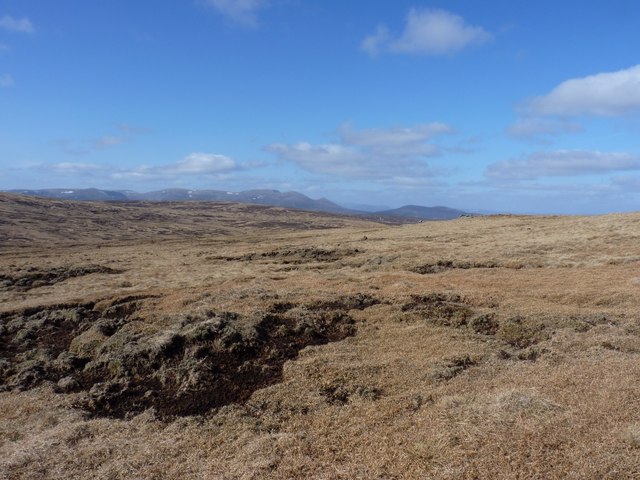
A corrie, or a glacial valley, is a bowl-shaped hollow formed by the erosive action of a glacier. Corrie of Bonhard was created during the last Ice Age, around 10,000 years ago, when a glacier moved across the landscape, carving out the valley as it advanced and retreated.

The corrie is characterized by steep, rocky sides and a flat bottom. It is approximately 700 meters long and 300 meters wide, with an elevation of around 150 meters above sea level. The valley is surrounded by rolling hills and offers a picturesque view of the surrounding countryside.

Corrie of Bonhard is also notable for its rich biodiversity. The valley is home to a variety of plant and animal species, including heather, mosses, lichens, and various bird species. The presence of these species reflects the diverse range of habitats that can be found within the corrie.

Today, Corrie of Bonhard is a popular destination for hikers and nature enthusiasts. Its natural beauty and historical significance make it an ideal location for those seeking to explore and learn about Scotland's glacial past.

If you have any feedback on the listing, please let us know in the comments section below.

Corrie of Bonhard Images

Images are sourced within 2km of 56.863884/-3.1282625 or Grid Reference NO3175. Thanks to Geograph Open Source API. All images are credited.

Atton below Cairn Inks Carlowie is the corrie with Bassies the hill on the right.
Atton below Cairn Inks
Carlowie is the corrie with Bassies the hill on the right.
Landslip or slumping After much heavy rain the hillside has slipped down taking out the fence beside the road. Any more and the road to Braedownie and Acharn will be blocked.
Landslip or slumping
After much heavy rain the hillside has slipped down taking out the fence beside the road. Any more and the road to Braedownie and Acharn will be blocked.
Ruined dwelling at Bontyre, Glen Clova See also <a href="https://www.geograph.org.uk/photo/472227">NO3074 : Ruin, Glen Clova.</a> The ruins may have been a shepherd's home as nearby there remains evidence of a fairly large fank.
Ruined dwelling at Bontyre, Glen Clova
See also NO3074 : Ruin, Glen Clova. The ruins may have been a shepherd's home as nearby there remains evidence of a fairly large fank.
Remains of fank, Glen Clova The outline of stones indicate the possibility of a fairly large fank being in existence. Nearby there are the ruins of a dwelling. See <a href="https://www.geograph.org.uk/photo/5466583">NO3074 : Ruined dwelling at Bontyre, Glen Clova</a>
Remains of fank, Glen Clova
The outline of stones indicate the possibility of a fairly large fank being in existence. Nearby there are the ruins of a dwelling. See NO3074 : Ruined dwelling at Bontyre, Glen Clova
Corrie of Bonhard drops sharply below Driesh is the hill across Glen Clova.
Corrie of Bonhard drops sharply below
Driesh is the hill across Glen Clova.
Red Craig The rocky lower slopes.
Red Craig
The rocky lower slopes.
Road up Glen Clova At the head of the glen on a February morning.
Road up Glen Clova
At the head of the glen on a February morning.
The Corrie of Clova
The Corrie of Clova
Burn of Bonhard Descending from Corrie of Bonhard.
Burn of Bonhard
Descending from Corrie of Bonhard.
Burning debris after clear felling Filling Glen Clova with wood smoke!  A legal arsonist?
Burning debris after clear felling
Filling Glen Clova with wood smoke! A legal arsonist?
Northwest towards Lochnagar Rough, boggy ground on the western side of Benty Roads.
Northwest towards Lochnagar
Rough, boggy ground on the western side of Benty Roads.
Peat bog below Boustie Ley
Towards Mount Keen from Boustie Ley
The eastern side of Boustie Ley This is open, flattish country with easy walking over short arctic vegetation once you're away from the occasional boggy patch. This shot looks back along the north ridge of Glen Clova towards the Corbett called Ben Tirran or The Goet, about 3 miles to the east.
The eastern side of Boustie Ley
This is open, flattish country with easy walking over short arctic vegetation once you're away from the occasional boggy patch. This shot looks back along the north ridge of Glen Clova towards the Corbett called Ben Tirran or The Goet, about 3 miles to the east.
Summit cairn on Boustie Ley No more than a small pile of rocks on this little-visited summit.
Summit cairn on Boustie Ley
No more than a small pile of rocks on this little-visited summit.
Towards Mount Keen from the summit area of Boustie Ley
Into Glen Clova from Boustie Ley The intriguingly-named Laird's Bedchamber forms the hill on the right, a ridge that reaches down from Boustie Ley, before the land drops away into Glen Clova below.
Into Glen Clova from Boustie Ley
The intriguingly-named Laird's Bedchamber forms the hill on the right, a ridge that reaches down from Boustie Ley, before the land drops away into Glen Clova below.
Ben Reid from Boustie Ley The lump of Ben Reid, which looms above Glen Clova.
Ben Reid from Boustie Ley
The lump of Ben Reid, which looms above Glen Clova.
Show me another place!

Corrie of Bonhard is located at Grid Ref: NO3175 (Lat: 56.863884, Lng: -3.1282625)

Unitary Authority: Angus

Police Authority: Tayside

What 3 Words

///dusty.expecting.bottle. Near Ballater, Aberdeenshire

Nearby Locations

Ben Reid Corrie of Bonhard

Related Wikis

Clova, Angus

Clova is a village in Glen Clova, Angus, Scotland. It lies on the River South Esk, some 12 miles (19 km) north of Kirriemuir. During the 1745 Jacobite...

Driesh

Driesh (Gaelic: Dris) is a mountain located in the Grampians of Scotland. Apart from Mount Keen (939 m/3,080 ft), it is the most easterly of the Munro...

Glen Doll

Glen Doll, also sometimes spelt Glendoll, lies within the Cairngorms National Park, Scotland, at the top of Glen Clova, in an area of steep hills, corries...

Ben Tirran

Ben Tirran (896 m) is a mountain in the Grampian Mountains of Scotland. It lies in the vast Mounth area of the eastern Highlands in Angus, on the northern...

Nearby Amenities

Located within 500m of 56.863884,-3.1282625
Corrie of Bonhard
Natural: valley
Valley: cirque
Lat/Long: 56.8649617/-3.1265794
The data included in this document is from www.openstreetmap.org. The data is made available under ODbL.

Have you been to Corrie of Bonhard?

Leave your review of Corrie of Bonhard below (or comments, questions and feedback).