Coire Nathrach

Corrie (Glacial Valley) in Banffshire

Scotland

Coire Nathrach

Coire nan Sac A small corrie draining into the River Avon near Dail nan Sac.
Coire nan Sac Credit: Anne Burgess

Coire Nathrach, also known as Corrie, is a glacial valley located in Banffshire, Scotland. Nestled within the Cairngorms National Park, it is a picturesque and enchanting destination for nature lovers and outdoor enthusiasts.

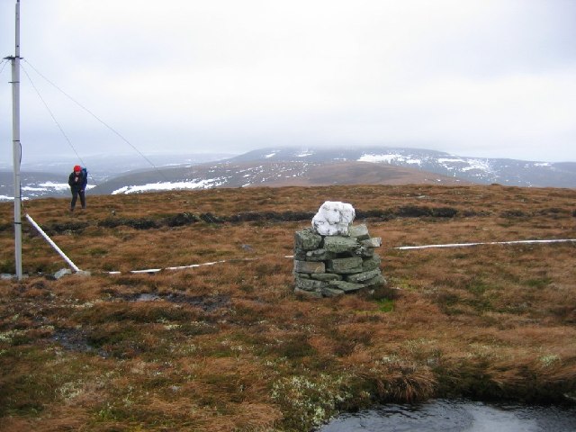
The valley is surrounded by majestic mountains, with the distinctive peaks of Braeriach and Cairn Toul dominating the landscape. These mountains provide a stunning backdrop to the valley, adding to its scenic beauty. Coire Nathrach is characterized by its steep sides and U-shaped profile, which are typical features of glacial valleys formed during the last ice age.

The valley is home to a diverse range of flora and fauna, including various species of alpine plants, mountain hare, and golden eagles. The surrounding hillsides are covered in heather and scattered with granite boulders, creating a unique and rugged environment.

For hikers and climbers, Coire Nathrach offers a plethora of opportunities to explore the surrounding mountains. There are numerous trails and paths that lead to the summits of Braeriach and Cairn Toul, providing breathtaking panoramic views of the surrounding Cairngorms.

Visitors to Coire Nathrach can also enjoy other outdoor activities such as birdwatching, photography, and simply immersing themselves in the tranquility of the Scottish Highlands. The valley's remote location and relatively untouched natural beauty make it a popular destination for those seeking solitude and a connection with nature.

Overall, Coire Nathrach is a captivating glacial valley in Banffshire, Scotland, offering stunning vistas, diverse wildlife, and a range of outdoor activities for nature enthusiasts to enjoy.

If you have any feedback on the listing, please let us know in the comments section below.

Coire Nathrach Images

Images are sourced within 2km of 57.176971/-3.4044168 or Grid Reference NJ1510. Thanks to Geograph Open Source API. All images are credited.

Coire nan Sac A small corrie draining into the River Avon near Dail nan Sac.
Coire nan Sac
A small corrie draining into the River Avon near Dail nan Sac.
River Avon Looking upriver, with the steep slope of The Neilead on the left.
River Avon
Looking upriver, with the steep slope of The Neilead on the left.
Allt Nathrach Allt Nathrach joins the River Avon here.
Allt Nathrach
Allt Nathrach joins the River Avon here.
Rocky Outcrop I wonder if this might be a fault plane in the Glenfiddich Pelite Formation.
Rocky Outcrop
I wonder if this might be a fault plane in the Glenfiddich Pelite Formation.
Sròn a' Bhothain Mhòir Sròn a' Bhothain Mhòir is the point on the left bank where the River Avon turns northwards again.
Sròn a' Bhothain Mhòir
Sròn a' Bhothain Mhòir is the point on the left bank where the River Avon turns northwards again.
Burn of Little Fergie The burn and its tributaries have cut a narrow glen though the glacial deposits beside Strath Avon.
Burn of Little Fergie
The burn and its tributaries have cut a narrow glen though the glacial deposits beside Strath Avon.
Burn of Loin From Cnap Chaochan Aitinn. The tributary is Caochan Garvoun.
Burn of Loin
From Cnap Chaochan Aitinn. The tributary is Caochan Garvoun.
River Avon below Foal's Craig
On a heathery ridge above Glen Loin Ben Avon forms the background.
On a heathery ridge above Glen Loin
Ben Avon forms the background.
River Avon The nearer channel is actually from a spring a little further up the strath, which joins the main river here.
River Avon
The nearer channel is actually from a spring a little further up the strath, which joins the main river here.
Strath Avon One left, below the road, is the burn that emerges from a spring at the foot of The Neilead, which is the slope on the left. On the right is the main channel of the River Avon.
Strath Avon
One left, below the road, is the burn that emerges from a spring at the foot of The Neilead, which is the slope on the left. On the right is the main channel of the River Avon.
Early Morning Mist in Glen Avon
Summit of Cnap Chaochan Aitin. A 715m high hill in the eastern Monadh Ruadh was a tough proposition on a very windy day. The estate maintains a radio relay up here; it's quite a cluttered summit.
Summit of Cnap Chaochan Aitin.
A 715m high hill in the eastern Monadh Ruadh was a tough proposition on a very windy day. The estate maintains a radio relay up here; it's quite a cluttered summit.
The road to Inchrory. A wealth of physical geographical features can be seen from this point on the road, just beyond where it changes from tarmac to hardcore surface. There is a river terrace, a moraine, river braiding, all in a glaciated valley.
The road to Inchrory.
A wealth of physical geographical features can be seen from this point on the road, just beyond where it changes from tarmac to hardcore surface. There is a river terrace, a moraine, river braiding, all in a glaciated valley.
Caterpillar crossing. Fortunately, traffic levels are extremely low.
Caterpillar crossing.
Fortunately, traffic levels are extremely low.
Track, Glen Loin Hill track going down from Cnap Chaochan Aitinn to meet the main Glen Loin track.
Track, Glen Loin
Hill track going down from Cnap Chaochan Aitinn to meet the main Glen Loin track.
Burn of Loin Flowing through Glen Loin below scree slopes of Cnap Eas Chaorach.
Burn of Loin
Flowing through Glen Loin below scree slopes of Cnap Eas Chaorach.
Glen Loin Track passing below Cnap Chaochan Aitinn with the southwestern slopes of Cnap Eas Chaorach ahead.
Glen Loin
Track passing below Cnap Chaochan Aitinn with the southwestern slopes of Cnap Eas Chaorach ahead.
Show me another place!

Coire Nathrach is located at Grid Ref: NJ1510 (Lat: 57.176971, Lng: -3.4044168)

Unitary Authority: Moray

Police Authority: North East

What 3 Words

///students.glows.checked. Near Grantown-on-Spey, Highland

Related Wikis

Delnadamph Lodge

Delnadamph Lodge was located on the Balmoral Estate about 8 miles (13 km) north of the castle. The lodge and its estate lands were bought by Queen Elizabeth...

Tomintoul

Tomintoul ( ; from Scottish Gaelic: Tom an t-Sabhail, meaning "Hillock of the Barn") is a village in the Moray council area of Scotland in the historic...

Ben Avon

Ben Avon (Scottish Gaelic: Beinn Athfhinn, 'mountain of the Avon') is a mountain in the Cairngorms of Scotland. It is a sprawling mountain with a broad...

Nearby Amenities

Located within 500m of 57.176971,-3.4044168
Geal Chàrn
Ele: 613
Natural: peak
Lat/Long: 57.1803692/-3.4091876
The data included in this document is from www.openstreetmap.org. The data is made available under ODbL.

Have you been to Coire Nathrach?

Leave your review of Coire Nathrach below (or comments, questions and feedback).