Coire Fuar

Corrie (Glacial Valley) in Stirlingshire

Scotland

Coire Fuar

Trig point atop Ben Lomond
Trig point atop Ben Lomond Credit: Steven Brown

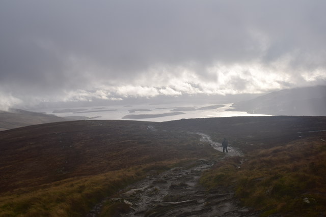
Coire Fuar, located in Stirlingshire, Scotland, is a glacial valley known for its stunning natural beauty and unique geological features. Also referred to as a corrie, this U-shaped valley was carved out by glacial activity during the last Ice Age.

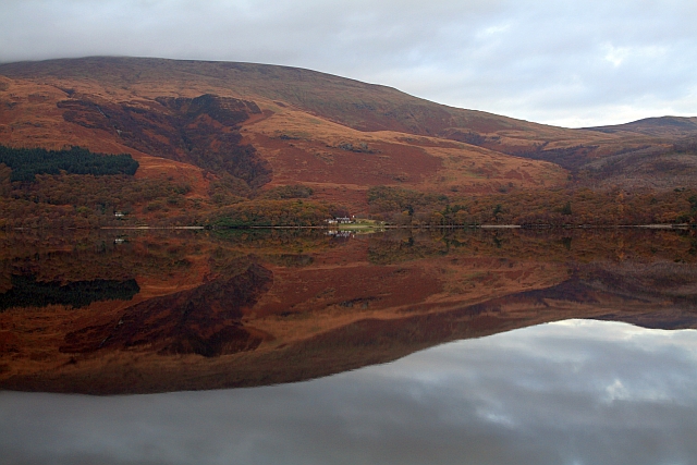
Situated in the southern part of the Scottish Highlands, Coire Fuar is surrounded by majestic mountain peaks, including Ben Vorlich and Stuc a' Chroin. The valley itself is characterized by steep, rocky slopes and a flat floor, which is often covered in lush vegetation and dotted with small lochans, or mountain lakes.

The name "Coire Fuar" translates to "cold corrie" in English, referring to the chilly temperatures that can be experienced here, particularly during the winter months. The valley is known for its microclimate, often experiencing cooler and wetter conditions compared to the surrounding areas.

Coire Fuar is a popular destination for hikers, mountaineers, and nature enthusiasts. It offers a range of outdoor activities, including walking trails that lead to the surrounding peaks, providing breathtaking panoramic views of the surrounding landscape.

The valley is also home to a diverse array of flora and fauna, with many rare and protected species found within its boundaries. Visitors may have the opportunity to spot wildlife such as red deer, golden eagles, and ptarmigans.

Overall, Coire Fuar is a captivating and picturesque location, offering visitors a chance to immerse themselves in Scotland's natural beauty and explore the remnants of its glacial past.

If you have any feedback on the listing, please let us know in the comments section below.

Coire Fuar Images

Images are sourced within 2km of 56.186839/-4.6170635 or Grid Reference NN3702. Thanks to Geograph Open Source API. All images are credited.

Trig point atop Ben Lomond
Ben Lomond The waterfall Sput Ban can be seen left of centre.
Ben Lomond
The waterfall Sput Ban can be seen left of centre.
Trig point, Ben Lomond A rather overcast and cloudy day on the summit of Ben Lomond (974m).
Trig point, Ben Lomond
A rather overcast and cloudy day on the summit of Ben Lomond (974m).
Ben Lomond A distant view of the mountain capped in mist.
Ben Lomond
A distant view of the mountain capped in mist.
Sota activation 2M0ROT/P & MM6SGO/P getting ready to activate the summit of Ben Lomond.
Summits on the Air website <span class="nowrap"><a title="http://www.sota.org.uk/" rel="nofollow ugc noopener" href="http://www.sota.org.uk/">Link</a><img style="margin-left:2px;" alt="External link" title="External link - shift click to open in new window" src="https://s1.geograph.org.uk/img/external.png" width="10" height="10"/></span>
Sota activation
2M0ROT/P & MM6SGO/P getting ready to activate the summit of Ben Lomond. Summits on the Air website LinkExternal link
Snow-covered Ben Lomond A long-range shot taken from the Corrie of Balglass near Fintry.
Snow-covered Ben Lomond
A long-range shot taken from the Corrie of Balglass near Fintry.
The Ben Appears Lower down grey skies prevailed - at 800m we broke through the clouds on the Ptarmigan Ridge route to the summit of Ben Lomond to reveal a different world.
First Munro for the Jack Russell pictured behind the figure.
The Ben Appears
Lower down grey skies prevailed - at 800m we broke through the clouds on the Ptarmigan Ridge route to the summit of Ben Lomond to reveal a different world. First Munro for the Jack Russell pictured behind the figure.
Quartz Outcrop Quartz outcrop on Ben Lomond
Quartz Outcrop
Quartz outcrop on Ben Lomond
Path on Ben Lomond Near the summit with a view over Loch Lomond towards Arrochar and Cowal.
Path on Ben Lomond
Near the summit with a view over Loch Lomond towards Arrochar and Cowal.
Ben Lomond Approaching the summit.
Ben Lomond
Approaching the summit.
Ben Lomond trig pillar Munro completion.  The pillar stood in for a cairn.
Ben Lomond trig pillar
Munro completion. The pillar stood in for a cairn.
Mist receding from Ben Lomond After a torrential hail shower, which shrouded the upper part of the mountain in cloud and whitened the ground, the cloud cleared dramatically.  Some hill fog still clings on in the north-east corrie (Coire a' Bhathaich - 'corrie of the barn').
Mist receding from Ben Lomond
After a torrential hail shower, which shrouded the upper part of the mountain in cloud and whitened the ground, the cloud cleared dramatically. Some hill fog still clings on in the north-east corrie (Coire a' Bhathaich - 'corrie of the barn').
Beginning (or end) of the Ptarmigan Path on Ben Lomond The route over the top named Ptarmigan is quieter than the main route up from Rowardennan, but still quite well-worn nowadays.
Beginning (or end) of the Ptarmigan Path on Ben Lomond
The route over the top named Ptarmigan is quieter than the main route up from Rowardennan, but still quite well-worn nowadays.
Ben Lomond seen from Duncryne A view up Loch Lomond.
Ben Lomond seen from Duncryne
A view up Loch Lomond.
Sron Aonaich Heading towards Ben Lomond.
Sron Aonaich
Heading towards Ben Lomond.
The Ben Lomond hill path. Looking back towards Loch Lomond.
The Ben Lomond hill path.
Looking back towards Loch Lomond.
The Ben Lomond hill path. Rough weather on Ben Lomond.
The Ben Lomond hill path.
Rough weather on Ben Lomond.
Path near the summit of Ben Lomond. Wet and windy.
Path near the summit of Ben Lomond.
Wet and windy.
Show me another place!

Coire Fuar is located at Grid Ref: NN3702 (Lat: 56.186839, Lng: -4.6170635)

Unitary Authority: Stirling

Police Authority: Forth Valley

What 3 Words

///captions.trail.poetic. Near Garelochhead, Argyll & Bute

Related Wikis

Ben Lomond

Ben Lomond (Scottish Gaelic: Beinn Laomainn, 'Beacon Mountain'), 974 metres (3,196 ft), is a mountain in the Scottish Highlands. Situated on the eastern...

Loch Dubh (Loch Ard Forest)

Loch Dubh ("Black Loch") is a lochan on the Duchray Water in the western part of Loch Ard Forest in the Central Highlands of Scotland. == Location == Loch...

Rowardennan

Rowardennan (Gaelic: Rubha Aird Eònain) is a small rural community on the eastern shore of Loch Lomond in Stirling council, Scotland. It is mainly known...

Eilean nan Deargannan

Eilean nan Deargannan (sometimes written as Eilean Deargannan) is a small island in Loch Lomond, in west central Scotland. It lies between Rowardennan...

Nearby Amenities

Located within 500m of 56.186839,-4.6170635
Coire a' Fuar
Place: locality
Lat/Long: 56.1864393/-4.6184176
The data included in this document is from www.openstreetmap.org. The data is made available under ODbL.

Have you been to Coire Fuar?

Leave your review of Coire Fuar below (or comments, questions and feedback).