Coire a' Bhàthaich

Valley in Stirlingshire

Scotland

Coire a' Bhàthaich

Trig point atop Ben Lomond
Trig point atop Ben Lomond Credit: Steven Brown

Coire a' Bhàthaich is a picturesque valley located in Stirlingshire, Central Scotland. Nestled within the majestic Trossachs National Park, this valley offers breathtaking natural beauty and a tranquil escape from the hustle and bustle of everyday life.

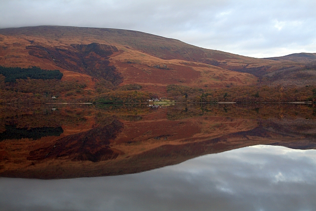
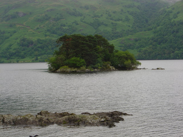
The valley is characterized by its rolling hills, lush green meadows, and dense forests that surround it. The centerpiece of Coire a' Bhàthaich is a crystal-clear stream that meanders through the valley, providing a serene soundtrack to the area. The stream is home to various species of fish, making it a popular spot for anglers.

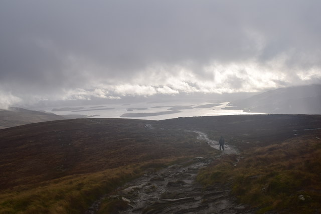
The valley is a haven for outdoor enthusiasts and nature lovers. It offers a multitude of walking and hiking trails that cater to all levels of fitness and experience. These trails provide stunning views of the surrounding landscape, including the nearby Loch Venachar and Loch Achray.

Wildlife is abundant in Coire a' Bhàthaich, with red deer, red squirrels, and a variety of bird species being commonly spotted. The valley is also home to a diverse range of plant life, including heather, bluebells, and wildflowers, which add a burst of color to the landscape.

Coire a' Bhàthaich is easily accessible, with a car park located nearby for visitors. It is a popular destination for day trips and picnics, allowing visitors to immerse themselves in the peaceful surroundings. Whether it's for a leisurely stroll or a more challenging hike, Coire a' Bhàthaich offers a truly enchanting experience in the heart of Stirlingshire.

If you have any feedback on the listing, please let us know in the comments section below.

Coire a' Bhàthaich Images

Images are sourced within 2km of 56.190585/-4.6247819 or Grid Reference NN3702. Thanks to Geograph Open Source API. All images are credited.

Trig point atop Ben Lomond
Ben Lomond The waterfall Sput Ban can be seen left of centre.
Ben Lomond
The waterfall Sput Ban can be seen left of centre.
Trig point, Ben Lomond A rather overcast and cloudy day on the summit of Ben Lomond (974m).
Trig point, Ben Lomond
A rather overcast and cloudy day on the summit of Ben Lomond (974m).
Ben Lomond A distant view of the mountain capped in mist.
Ben Lomond
A distant view of the mountain capped in mist.
Sota activation 2M0ROT/P & MM6SGO/P getting ready to activate the summit of Ben Lomond.
Summits on the Air website <span class="nowrap"><a title="http://www.sota.org.uk/" rel="nofollow ugc noopener" href="http://www.sota.org.uk/">Link</a><img style="margin-left:2px;" alt="External link" title="External link - shift click to open in new window" src="https://s1.geograph.org.uk/img/external.png" width="10" height="10"/></span>
Sota activation
2M0ROT/P & MM6SGO/P getting ready to activate the summit of Ben Lomond. Summits on the Air website LinkExternal link
Snow-covered Ben Lomond A long-range shot taken from the Corrie of Balglass near Fintry.
Snow-covered Ben Lomond
A long-range shot taken from the Corrie of Balglass near Fintry.
The Ben Appears Lower down grey skies prevailed - at 800m we broke through the clouds on the Ptarmigan Ridge route to the summit of Ben Lomond to reveal a different world.
First Munro for the Jack Russell pictured behind the figure.
The Ben Appears
Lower down grey skies prevailed - at 800m we broke through the clouds on the Ptarmigan Ridge route to the summit of Ben Lomond to reveal a different world. First Munro for the Jack Russell pictured behind the figure.
The Arrochar Alps Looking Alpine....cloud inversion over The Cobbler, Beinn Narnain, Ben Ime and Ben Vane with Beinn an Lochain between The Cobbler and Beinn Narnain.
A fantastic day on Scotlands most popular Munro.
The Arrochar Alps
Looking Alpine....cloud inversion over The Cobbler, Beinn Narnain, Ben Ime and Ben Vane with Beinn an Lochain between The Cobbler and Beinn Narnain. A fantastic day on Scotlands most popular Munro.
Quartz Outcrop Quartz outcrop on Ben Lomond
Quartz Outcrop
Quartz outcrop on Ben Lomond
Path on Ben Lomond Near the summit with a view over Loch Lomond towards Arrochar and Cowal.
Path on Ben Lomond
Near the summit with a view over Loch Lomond towards Arrochar and Cowal.
Ben Lomond Approaching the summit.
Ben Lomond
Approaching the summit.
Ben Lomond trig pillar Munro completion.  The pillar stood in for a cairn.
Ben Lomond trig pillar
Munro completion. The pillar stood in for a cairn.
Mist receding from Ben Lomond After a torrential hail shower, which shrouded the upper part of the mountain in cloud and whitened the ground, the cloud cleared dramatically.  Some hill fog still clings on in the north-east corrie (Coire a' Bhathaich - 'corrie of the barn').
Mist receding from Ben Lomond
After a torrential hail shower, which shrouded the upper part of the mountain in cloud and whitened the ground, the cloud cleared dramatically. Some hill fog still clings on in the north-east corrie (Coire a' Bhathaich - 'corrie of the barn').
Beginning (or end) of the Ptarmigan Path on Ben Lomond The route over the top named Ptarmigan is quieter than the main route up from Rowardennan, but still quite well-worn nowadays.
Beginning (or end) of the Ptarmigan Path on Ben Lomond
The route over the top named Ptarmigan is quieter than the main route up from Rowardennan, but still quite well-worn nowadays.
Ben Lomond seen from Duncryne A view up Loch Lomond.
Ben Lomond seen from Duncryne
A view up Loch Lomond.
Sron Aonaich Heading towards Ben Lomond.
Sron Aonaich
Heading towards Ben Lomond.
The Ben Lomond hill path. Looking back towards Loch Lomond.
The Ben Lomond hill path.
Looking back towards Loch Lomond.
The Ben Lomond hill path. Rough weather on Ben Lomond.
The Ben Lomond hill path.
Rough weather on Ben Lomond.
Show me another place!

Coire a' Bhàthaich is located at Grid Ref: NN3702 (Lat: 56.190585, Lng: -4.6247819)

Unitary Authority: Stirling

Police Authority: Forth Valley

What 3 Words

///envy.frown.slows. Near Garelochhead, Argyll & Bute

Related Wikis

Ben Lomond

Ben Lomond (Scottish Gaelic: Beinn Laomainn, 'Beacon Mountain'), 974 metres (3,196 ft), is a mountain in the Scottish Highlands. Situated on the eastern...

Loch Dubh (Loch Ard Forest)

Loch Dubh ("Black Loch") is a lochan on the Duchray Water in the western part of Loch Ard Forest in the Central Highlands of Scotland. == Location == Loch...

Rowardennan

Rowardennan (Gaelic: Rubha Aird Eònain) is a small rural community on the eastern shore of Loch Lomond in Stirling council, Scotland. It is mainly known...

Eilean nan Deargannan

Eilean nan Deargannan (sometimes written as Eilean Deargannan) is a small island in Loch Lomond, in west central Scotland. It lies between Rowardennan...

Tarbet Isle

Tarbet Isle is an island in Loch Lomond, Scotland. It is off Tarbet on the mainland. It is 10 feet (3.0 m) at its highest point, and 80 metres (260 ft...

Loch Chon

Loch Chon is a freshwater loch situated west of the village of Aberfoyle, near the small village of Kinlochard, Stirling, Scotland, UK. Loch Chon lies...

Inverbeg

Inverbeg is a settlement in Argyll and Bute, Scotland. Its Ordnance Survey grid reference is NS3497.It is on the western shore of Loch Lomond. There has...

Tarbet, Argyll

Tarbet (Scottish Gaelic: An Tairbeart, in full Tairbeart Loch Laomainn 'Crossing Place of Loch Lomond') is a small village in Argyll and Bute, Scotland...

Nearby Amenities

Located within 500m of 56.190585,-4.6247819
Coire a' Bhathaich
Place: locality
Lat/Long: 56.1909695/-4.6232651
The data included in this document is from www.openstreetmap.org. The data is made available under ODbL.

Have you been to Coire a' Bhàthaich?

Leave your review of Coire a' Bhàthaich below (or comments, questions and feedback).