Beckley

Settlement in Oxfordshire South Oxfordshire

England

Beckley

Oxford transmitting station, Beckley A television and radio station.
Oxford transmitting station, Beckley Credit: Robin Webster

Beckley is a charming village located in Oxfordshire, England. Situated approximately 6 miles northeast of the city of Oxford, Beckley lies on the slopes of Otmoor, providing its residents with scenic views of the surrounding countryside. With a population of around 600 people, this small village offers a peaceful and close-knit community atmosphere.

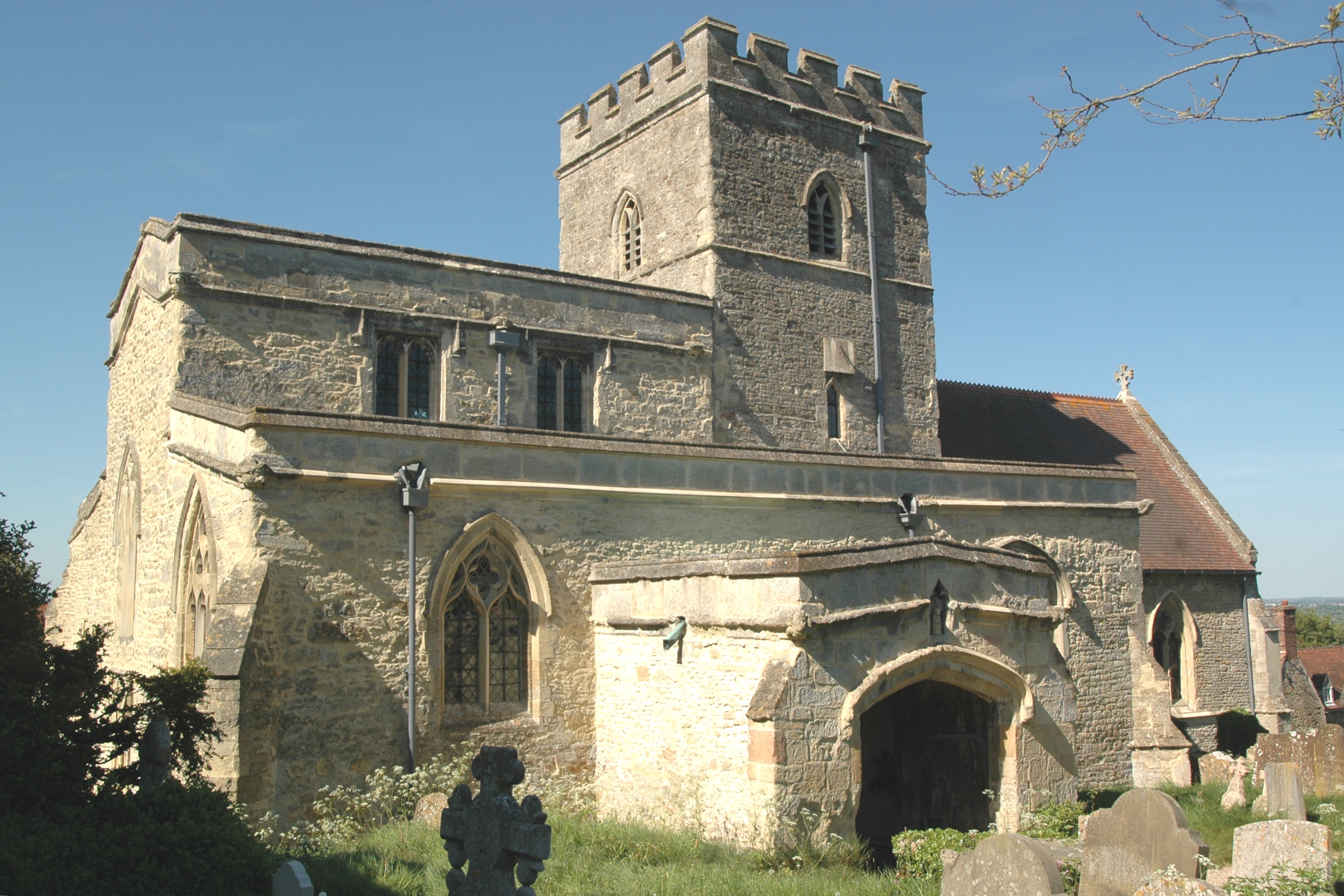
Beckley is known for its historic roots, with evidence of human settlement dating back to the Roman era. The village is home to the St. Mary the Virgin Church, a medieval parish church that has been standing since the 13th century. Its architectural beauty and historical significance make it a popular attraction for visitors.

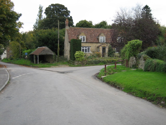
The village itself is characterized by picturesque thatched cottages, well-tended gardens, and a tranquil atmosphere. Despite its small size, Beckley is well-equipped with amenities to meet the needs of its residents. These include a village hall, a primary school, a post office, and a local pub, where locals can gather for a friendly chat and a pint.

Nature enthusiasts will find plenty to explore in the surrounding area. Beckley is surrounded by lush green fields and meadows, making it an ideal destination for countryside walks and hikes. Additionally, the nearby Otmoor RSPB nature reserve provides a haven for birdwatchers, with a variety of bird species to observe.

Overall, Beckley offers a peaceful and idyllic setting, combining historical charm with natural beauty. Its close proximity to Oxford allows residents to enjoy the benefits of both a serene village lifestyle and easy access to the amenities and cultural offerings of a larger city.

If you have any feedback on the listing, please let us know in the comments section below.

Beckley Images

Images are sourced within 2km of 51.793442/-1.17484 or Grid Reference SP5710. Thanks to Geograph Open Source API. All images are credited.

Oxford transmitting station, Beckley A television and radio station.
Oxford transmitting station, Beckley
A television and radio station.
The Closes, RSPB Otmoor An area of wet grassland. Ot Moor was first drained in 1816 and had been divided up into fields by 1830. Since 1997 the RSPB have been recreating wetlands here.
The Closes, RSPB Otmoor
An area of wet grassland. Ot Moor was first drained in 1816 and had been divided up into fields by 1830. Since 1997 the RSPB have been recreating wetlands here.
Managed land, RSPB Otmoor A lot of shrubs have been cut down to ground level.
Managed land, RSPB Otmoor
A lot of shrubs have been cut down to ground level.
No entry to a conservation area, RSPB Otmoor Ot Moor was first drained in 1816 and had been divided up into fields by 1830. Since 1997 the RSPB have been recreating wetlands here.
No entry to a conservation area, RSPB Otmoor
Ot Moor was first drained in 1816 and had been divided up into fields by 1830. Since 1997 the RSPB have been recreating wetlands here.
Bridleway on the route of a Roman road, near RSPB Otmoor Looking north.
Bridleway on the route of a Roman road, near RSPB Otmoor
Looking north.
Woodperry Manor
Woodperry Manor
Folly Farm
Folly Farm
Beckley
Beckley
Assumption of the Blessed Virgin Mary Church, Beckley
Roman road near Beckley The roman road across Otmoor is a bridleway. This section is between the RSPB reserve and the military firing range.
Roman road near Beckley
The roman road across Otmoor is a bridleway. This section is between the RSPB reserve and the military firing range.
Drainage ditch on Otmoor View from the roman road across Otmoor. Here it is just between the RSPB area which is being converted back to wetland, and the Ministry of Defence firing range.
Drainage ditch on Otmoor
View from the roman road across Otmoor. Here it is just between the RSPB area which is being converted back to wetland, and the Ministry of Defence firing range.
Discreet silo Nicely positioned between two trees on the brow of the hill.
Discreet silo
Nicely positioned between two trees on the brow of the hill.
Television masts Viewed from New Inn Road.
Television masts
Viewed from New Inn Road.
House by road junction At the point where the Elsfield to Beckley road crosses the B4027.
House by road junction
At the point where the Elsfield to Beckley road crosses the B4027.
Pasture and Noke Wood View from Folly Farm, Beckley, looking towards Otmoor. It seems to be newly sown grass.
Pasture and Noke Wood
View from Folly Farm, Beckley, looking towards Otmoor. It seems to be newly sown grass.
Horses in field, flooded Otmoor beyond View from the Oxfordshire Way footpath near Upper Park Farm. Although the field is only at 110 metres it gives a view right over the flat Otmoor at 60m. Otmoor used to be drained, the RSPB is turning parts back into wetlands, see <a href="https://www.geograph.org.uk/photo/181465">SP5613 : RSPB reedbed on Otmoor</a>.
Horses in field, flooded Otmoor beyond
View from the Oxfordshire Way footpath near Upper Park Farm. Although the field is only at 110 metres it gives a view right over the flat Otmoor at 60m. Otmoor used to be drained, the RSPB is turning parts back into wetlands, see SP5613 : RSPB reedbed on Otmoor.
Blackwater Wood View from road.
Blackwater Wood
View from road.
That was a tree that was This had been a large tree at the Woodperry road junction. View from standing on the cut tree stump, into wheatfield.
That was a tree that was
This had been a large tree at the Woodperry road junction. View from standing on the cut tree stump, into wheatfield.
Show me another place!

Beckley is located at Grid Ref: SP5710 (Lat: 51.793442, Lng: -1.17484)

Administrative County: Oxfordshire

District: South Oxfordshire

Police Authority: Thames Valley

What 3 Words

///noticing.yield.headboard. Near Wheatley, Oxfordshire

Nearby Locations

Beckley

Related Wikis

Oxford transmitting station

The Oxford transmitting station (sometimes known as the Beckley transmitter) is a broadcasting and telecommunications facility, situated on land 129.5...

Woodperry House

Woodperry House is a Grade I listed building in Stanton St John, South Oxfordshire, England. Woodperry was built from 1728 for John Morse, a London goldsmith...

Beckley, Oxfordshire

Beckley is a village in the civil parish of Beckley and Stowood, in the South Oxfordshire district, in the county of Oxfordshire, England. It is about...

Beckley and Stowood

Beckley and Stowood is a civil parish in the South Oxfordshire district of Oxfordshire, England. According to the United Kingdom Census 2011 it had a...
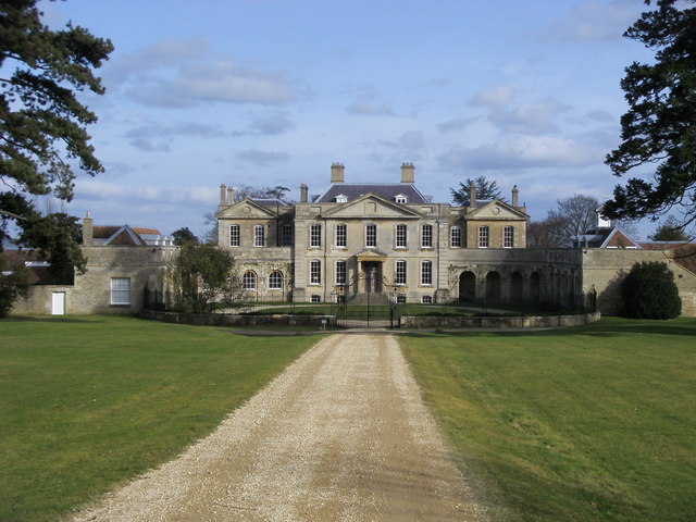
Beckley Park

Beckley Park is an English country house located near the village of Beckley, in Oxfordshire, England. It was built in 1540 by Lord Williams of Thame,...

Looping Star (Clacton Pier)

Looping Star is a steel roller coaster located at Clacton Pier in Clacton-on-Sea, Essex manufactured by Pinfari. It was formerly located at Codonas Amusement...

Holly Wood, Oxfordshire

Holly Wood is a 25.6-hectare (63-acre) biological Site of Special Scientific Interest north-east of Oxford in Oxfordshire.This ancient wood is a small...

Stanton St. John

Stanton St. John is a village and civil parish in Oxfordshire about 4.5 miles (7 km) northeast of the centre of Oxford. The village is 330 feet (100 m...

Nearby Amenities

Located within 500m of 51.793442,-1.17484
Oxford transmitter
Alt Name: Beckley Transmitter
Communication Radio: yes
Communication Television: yes
Ele: 129
Height: 166
Man Made: mast
Tower Construction: guyed_lattice
Tower Type: communication
Lat/Long: 51.7906498/-1.1791025
Post Box
Collection Times: Mo-Fr 09:00; Sa 07:00
Post Box Type: lamp
Ref: OX3 356
Royal Cypher: EIIR
Royal Cypher Wikidata: Q33102113
Lat/Long: 51.7941515/-1.1766078
Bus Stop
Woodperry Road
Bus: yes
Naptan AtcoCode: 340001746OPB
Naptan Bearing: SE
Naptan CommonName: Woodperry Road
Naptan Indicator: Opposite Beckley Court
Naptan Landmark: Beckley Court
Naptan NaptanCode: oxfgdjdp
Naptan Notes: Timetable Case Only
Naptan Street: Woodperry Road
Public Transport: platform
Route Ref: 108;118
Source: naptan_import
Lat/Long: 51.7939773/-1.1758256
Woodperry Road
Naptan AtcoCode: 340001746OUB
Naptan Bearing: NW
Naptan BusStopType: CUS
Naptan CommonName: Woodperry Road
Naptan Indicator: Outside Beckley Court
Naptan Landmark: Beckley Court
Naptan NaptanCode: oxfgdjdm
Naptan Street: Woodperry Road
Source: naptan_import
Lat/Long: 51.7939604/-1.1759855
Grit Bin
Lat/Long: 51.7956175/-1.1811111
Woodperry Road SPS
Man Made: water_works
Operator: Thames Water
Ref: WOODPJZZ
Lat/Long: 51.792235/-1.1716734
Power: pole
Lat/Long: 51.7900616/-1.1714796
Power: pole
Lat/Long: 51.7907899/-1.1702696
Power: pole
Lat/Long: 51.7913625/-1.169381
Power: pole
Lat/Long: 51.7920504/-1.1683236
Archaeological Site: roman_villa
Civilization: roman
Historic: archaeological_site
Lat/Long: 51.7978283/-1.1757109
Power: pole
Lat/Long: 51.7930014/-1.1718295
Power: pole
Source: Bing
Lat/Long: 51.7911483/-1.1736171
Power: pole
Lat/Long: 51.7921926/-1.1687667
Power: pole
Lat/Long: 51.7926871/-1.1707888
Power: pole
Lat/Long: 51.7934757/-1.1711965
Power: pole
Lat/Long: 51.7939467/-1.1705737
Power: pole
Source: Bing
Lat/Long: 51.7948748/-1.1693004
Power: pole
Source: Bing
Lat/Long: 51.7953552/-1.1686686
Power: pole
Lat/Long: 51.7944129/-1.1699361
Power: pole
Source: Bing
Lat/Long: 51.7892706/-1.1753871
Power: pole
Source: Bing
Lat/Long: 51.7902741/-1.1745208
Man Made: tower
Tower Construction: lattice
Tower Type: communication
Lat/Long: 51.7903431/-1.1786366
Leisure: playground
Lat/Long: 51.79481/-1.1761445
Power: pole
Lat/Long: 51.7924949/-1.1725029
Direction: 215
Generator Method: photovoltaic
Generator Output Electricity: yes
Generator Solar Modules: 210
Generator Source: solar
Generator Type: solar_photovoltaic_panel
Location: roof
Power: generator
Lat/Long: 51.7898479/-1.1733364
Direction: 200
Generator Method: photovoltaic
Generator Output Electricity: yes
Generator Solar Modules: 16
Generator Source: solar
Generator Type: solar_photovoltaic_panel
Location: roof
Power: generator
Lat/Long: 51.7926908/-1.1752344
Direction: 190
Generator Method: photovoltaic
Generator Output Electricity: yes
Generator Solar Modules: 7
Generator Source: solar
Generator Type: solar_photovoltaic_panel
Location: roof
Power: generator
Lat/Long: 51.7947226/-1.178923
Direction: 100
Generator Method: photovoltaic
Generator Output Electricity: yes
Generator Solar Modules: 8
Generator Source: solar
Generator Type: solar_photovoltaic_panel
Location: roof
Power: generator
Lat/Long: 51.7946667/-1.1788772
Fixme: solar panels?
Lat/Long: 51.7949713/-1.1801497
Defibrillator
Emergency: defibrillator
Indoor: no
Lat/Long: 51.7943816/-1.1762529
The data included in this document is from www.openstreetmap.org. The data is made available under ODbL.

Have you been to Beckley?

Leave your review of Beckley below (or comments, questions and feedback).