Glac a' Chro

Corrie (Glacial Valley) in Argyllshire

Scotland

Glac a' Chro

Cairn on Meall an t-Slamain and view to Fort William
Cairn on Meall an t-Slamain and view to Fort William Credit: Steven Brown

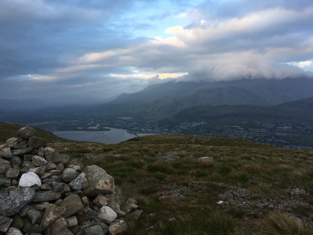
Glac a' Chro, also known as Corrie, is a glacial valley located in Argyllshire, Scotland. Nestled amidst the stunning Scottish Highlands, this natural wonder is characterized by its rugged terrain, majestic mountain peaks, and breathtaking landscapes.

Glac a' Chro was formed during the last Ice Age, when massive glaciers carved their way through the region, shaping the land into a U-shaped valley. Today, the valley is surrounded by towering mountains, including Ben Cruachan and Ben Lui, which add to the dramatic beauty of the area.

The valley is renowned for its rich biodiversity and is home to a variety of flora and fauna. Visitors to Glac a' Chro can expect to encounter a diverse range of plant species, including heather, mosses, and ferns, while sightings of red deer, golden eagles, and ptarmigans are not uncommon.

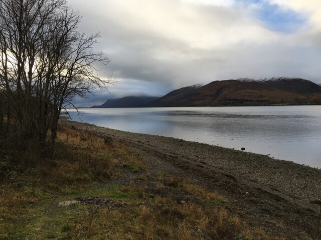
The glacial valley also features a picturesque river, which meanders through the landscape, adding to its charm. The crystal-clear waters are ideal for fishing enthusiasts, who can try their luck at catching trout or salmon.

Glac a' Chro attracts outdoor enthusiasts from around the world, offering a plethora of activities to suit all interests. Hiking and mountaineering opportunities abound, with numerous trails and paths leading through the valley and up the surrounding peaks. Additionally, the region is a popular destination for rock climbing and wildlife photography.

In conclusion, Glac a' Chro is a truly captivating location in Argyllshire, Scotland. Its glacial valleys, striking mountains, and abundant wildlife make it a must-visit destination for nature lovers and adventure seekers alike.

If you have any feedback on the listing, please let us know in the comments section below.

Glac a' Chro Images

Images are sourced within 2km of 56.822332/-5.1383804 or Grid Reference NN0874. Thanks to Geograph Open Source API. All images are credited.

Cairn on Meall an t-Slamain and view to Fort William
Grassy slopes above Achaphubuil
West End car park, Fort William
Shoreline of Loch Linnhe near Fort William
Achintore Road (A82), Fort William
Camusnagaul on a very dreich day
View from mast track to Camusnagaul
Restricted Access Sign on track to Camusnagaul
Masts at Camusnagaul
View of Loch walking down hill
Cruise ship at Fort William The 29,000 tonne cruise ship 'Amadea' is seen here anchored in Loch Linnhe off Fort William. The orange vessel at the jetty is one of her tenders ferrying passengers to and from the ship.
Cruise ship at Fort William
The 29,000 tonne cruise ship 'Amadea' is seen here anchored in Loch Linnhe off Fort William. The orange vessel at the jetty is one of her tenders ferrying passengers to and from the ship.
Sheet piling on the waterfront at Fort William Upholding the A82 road.
Sheet piling on the waterfront at Fort William
Upholding the A82 road.
Scenic Eclipse II at Fort William Scenic Eclipse II is a 168 metre “ice-strengthened expedition mega-yacht” that was built in Rijeka, Croatia. This ship can house 228 guests and 176 crew across an impressive 10 decks.
Scenic Eclipse II at Fort William
Scenic Eclipse II is a 168 metre “ice-strengthened expedition mega-yacht” that was built in Rijeka, Croatia. This ship can house 228 guests and 176 crew across an impressive 10 decks.
Seafood restaurant, Fort William The Crannog restaurant on the shore of Loch Linnhe.
Seafood restaurant, Fort William
The Crannog restaurant on the shore of Loch Linnhe.
Landing stage, Fort William A pontoon landing stage for the passenger ferry across Loch Linnhe to Camusnagaul.
Landing stage, Fort William
A pontoon landing stage for the passenger ferry across Loch Linnhe to Camusnagaul.
Former low level observatory, Fort William At the instigation of the Scottish Meteorological Society, the summit observatory on Ben Nevis opened in October 1883. Subsequently funding of £1000 became available from the Edinburgh International Exhibition in 1886 to build a companion low level observatory in Fort William. A telegraph connection enabled simultaneous comparison of weather conditions between the summit (1345m) and this near sea level  location. The low level observatory opened in July 1890, and both observatories ran until financial difficulties eventually forced closure in 1904. (Source: The Weathermen of Ben Nevis by Marjory Roy, Royal Meteorological Society 2004).

Now the house is the Glentower B&B. See also <a href="https://www.geograph.org.uk/photo/5695715">NN0973 : Glentower Lower Observatory, Achintore Road</a> by Craig Wallace.
Former low level observatory, Fort William
At the instigation of the Scottish Meteorological Society, the summit observatory on Ben Nevis opened in October 1883. Subsequently funding of £1000 became available from the Edinburgh International Exhibition in 1886 to build a companion low level observatory in Fort William. A telegraph connection enabled simultaneous comparison of weather conditions between the summit (1345m) and this near sea level location. The low level observatory opened in July 1890, and both observatories ran until financial difficulties eventually forced closure in 1904. (Source: The Weathermen of Ben Nevis by Marjory Roy, Royal Meteorological Society 2004). Now the house is the Glentower B&B. See also NN0973 : Glentower Lower Observatory, Achintore Road by Craig Wallace.
Lochside car park, Fort William By the A82 at the southern end of the town.
Lochside car park, Fort William
By the A82 at the southern end of the town.
Fort William welcome sign A sign on the A82 entering from the south. The gaelic name translates as 'the garrison'.
Fort William welcome sign
A sign on the A82 entering from the south. The gaelic name translates as 'the garrison'.
Show me another place!

Glac a' Chro is located at Grid Ref: NN0874 (Lat: 56.822332, Lng: -5.1383804)

Unitary Authority: Highland

Police Authority: Highlands and Islands

What 3 Words

///afflicted.abstracts.automate. Near Fort William, Highland

Related Wikis

Trislaig

Trislaig (Scottish Gaelic: Trìoslaig) is a small coastal hamlet on the north eastern shores of Loch Linnhe, and is situated directly across from Fort...

Achaphubuil

Achaphubuil (Scottish Gaelic: Achadh a' Phùbaill- the field of the tent or pavilion) is a small settlement to the north of Ardgour in Lochaber, in the...

West Highland Museum

The West Highland Museum (Scottish Gaelic: Taigh-tasgaidh na Gàidhealtachd an Iar) tells the story of the Scottish Highlands and the Islands. It aims to...

HMS St Christopher (shore establishment)

HMS St Christopher was a Coastal Forces training base of the Royal Navy operational during the Second World War and located in and around Fort William...

Nearby Amenities

Located within 500m of 56.822332,-5.1383804
Treslaig tower
Man Made: tower
Operator: Northern Police
Tower Construction: freestanding
Lat/Long: 56.8256418/-5.1384858
Bus Stop
Chalet Road End
Local Ref: AT
Naptan AtcoCode: 6700713225
Naptan Bearing: N
Naptan CommonName: Chalet Road End
Naptan Indicator: at
Naptan Landmark: Chalets
Naptan NaptanCode: 45328583
Naptan Street: A861
Naptan Verified: no
Source: naptan_import
Lat/Long: 56.8192897/-5.1345624
Bus Stop
Chalet Road End
Naptan AtcoCode: 6700713225A
Naptan Bearing: S
Naptan CommonName: Chalet Road End
Naptan Indicator: opp
Naptan Landmark: Chalets
Naptan NaptanCode: 45329545
Naptan Street: A861
Naptan Verified: no
Source: naptan_import
Lat/Long: 56.8192657/-5.1344457
Trislaig
Name Gd: Trinnsleig
Place: hamlet
Lat/Long: 56.8207702/-5.1333726
Daldrishaig
Place: isolated_dwelling
Lat/Long: 56.8196723/-5.1360279
Treslaig Tower Viewpoint
Tourism: viewpoint
Lat/Long: 56.8252012/-5.1397636
Glac a' Chrò
Place: locality
Lat/Long: 56.8224289/-5.1389408
Power: pole
Lat/Long: 56.8179081/-5.138382
Power: pole
Lat/Long: 56.8185423/-5.1380601
Power: pole
Lat/Long: 56.8193731/-5.1376498
Power: pole
Lat/Long: 56.8197271/-5.1371094
Power: pole
Lat/Long: 56.8203138/-5.1364356
Power: pole
Lat/Long: 56.8207595/-5.1354909
Power: pole
Lat/Long: 56.8210151/-5.1347109
Power: pole
Lat/Long: 56.8212593/-5.1340671
Power: pole
Lat/Long: 56.8222891/-5.132585
Power: pole
Lat/Long: 56.8227283/-5.1316313
Power: pole
Lat/Long: 56.8230527/-5.1304859
Power: pole
Lat/Long: 56.8194862/-5.1368219
The data included in this document is from www.openstreetmap.org. The data is made available under ODbL.

Have you been to Glac a' Chro?

Leave your review of Glac a' Chro below (or comments, questions and feedback).