Coire Toll a' Mhadaidh

Corrie (Glacial Valley) in Inverness-shire

Scotland

Coire Toll a' Mhadaidh

Mountain stream draining Coire an t-Siosalaich
Mountain stream draining Coire an t-Siosalaich Credit: Alan Reid

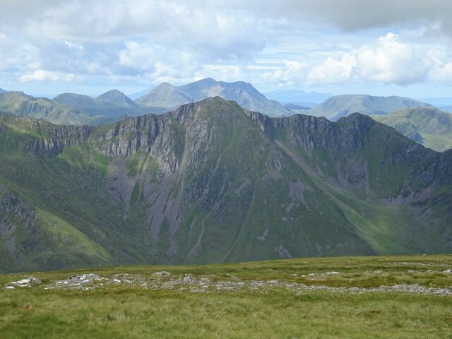
Coire Toll a' Mhadaidh is a glacial valley located in Inverness-shire, Scotland. It is situated within the Cuillin Mountains on the Isle of Skye. The valley is characterized by its steep, rocky walls and rugged terrain, which were carved out by glaciers during the last ice age.

The name "Coire Toll a' Mhadaidh" translates to "Corrie of the Wolf's Hole" in English, reflecting the wild and remote nature of the area. The valley is surrounded by stunning mountain peaks, including Sgurr na Banachdich and Sgurr a' Ghreadaidh, which provide a dramatic backdrop for visitors exploring the area.

Coire Toll a' Mhadaidh is a popular destination for hikers and climbers looking to challenge themselves in a rugged and picturesque setting. The valley offers a variety of routes and trails for all levels of experience, with opportunities to admire the stunning scenery and wildlife that call this area home.

Overall, Coire Toll a' Mhadaidh is a breathtaking natural wonder in Inverness-shire, offering visitors a chance to experience the beauty and power of glacial landscapes in the Scottish Highlands.

If you have any feedback on the listing, please let us know in the comments section below.

Coire Toll a' Mhadaidh Images

Images are sourced within 2km of 57.221762/-5.2697017 or Grid Reference NH0219. Thanks to Geograph Open Source API. All images are credited.

Mountain stream draining Coire an t-Siosalaich
Loch a' Bhealaich One of the two paths out of Affric to Kintail passes the loch before climbing to the Bealach an Sgàirne.  The view over the watershed is towards Mullach Fraoch-choire, which I crossed the previous day.
Loch a' Bhealaich
One of the two paths out of Affric to Kintail passes the loch before climbing to the Bealach an Sgàirne. The view over the watershed is towards Mullach Fraoch-choire, which I crossed the previous day.
Cairn on the north ridge of Beinn Fhada The cairn marks the top of the stalkers' path which climbs steeply to here from the upper part of Coire an Sgàirne.
The summit of Beinn Fhada is obscured by cloud.
Cairn on the north ridge of Beinn Fhada
The cairn marks the top of the stalkers' path which climbs steeply to here from the upper part of Coire an Sgàirne. The summit of Beinn Fhada is obscured by cloud.
Loch a' Bhealaich Looking from the path between Morvich and Glen Affric, which comes through the Bealach an Sgairne (centre).
Loch a' Bhealaich
Looking from the path between Morvich and Glen Affric, which comes through the Bealach an Sgairne (centre).
Evening at a wild camp in Gleann Gnìomhaidh After a long day traversing Beinn Fhada to the south with a hefty pack, this campsite came as a welcome relief. The cloud cleared overnight, leaving us to wake to a bright, frosty morning <a href="https://www.geograph.org.uk/photo/3417542">NH0320 : Morning at a wild camp in Gleann Gnìomhaidh</a>
Evening at a wild camp in Gleann Gnìomhaidh
After a long day traversing Beinn Fhada to the south with a hefty pack, this campsite came as a welcome relief. The cloud cleared overnight, leaving us to wake to a bright, frosty morning NH0320 : Morning at a wild camp in Gleann Gnìomhaidh
Looking down Gleann Gnìomhaidh A general view down the long, and little visited Gleann Gnìomhaidh, which leads down to Glen Affric to the east.
Looking down Gleann Gnìomhaidh
A general view down the long, and little visited Gleann Gnìomhaidh, which leads down to Glen Affric to the east.
The stalkers' track in Gleann Gnìomhaidh This well engineered track runs along much of the length of the glen, joining it to Glen Affric in the east and the Bealach an Sgàirne (The Gates of Affric) to the west.
The stalkers' track in Gleann Gnìomhaidh
This well engineered track runs along much of the length of the glen, joining it to Glen Affric in the east and the Bealach an Sgàirne (The Gates of Affric) to the west.
The stalkers' track near Cnoc na Cuaille
Loch a' Bhealaich and the Gates of Affric The low pass between the hills a mile distant (the Bealach an Sgàirne) is known as the Gates of Affric, as it provides one of the easier routes to Glen Affric from the west.
Loch a' Bhealaich and the Gates of Affric
The low pass between the hills a mile distant (the Bealach an Sgàirne) is known as the Gates of Affric, as it provides one of the easier routes to Glen Affric from the west.
Peat hags at Loch a' Bhealaich A large area of damp, peaty ground bounds the loch on its southern side.
Peat hags at Loch a' Bhealaich
A large area of damp, peaty ground bounds the loch on its southern side.
A small beach at the southern end of the loch Shingle rather than sand, and with some leaky peat just beside it, but no doubt a pleasant place on a brighter day.
A small beach at the southern end of the loch
Shingle rather than sand, and with some leaky peat just beside it, but no doubt a pleasant place on a brighter day.
Shingly beach on the eastern side of Loch a' Bhealaich The Munro of A' Ghlas-bheinn fills the horizon.
Shingly beach on the eastern side of Loch a' Bhealaich
The Munro of A' Ghlas-bheinn fills the horizon.
Outflow of a burn into Loch a' Bhealaich A small, un-named burn that drains the western slopes of Sgurr Gaorsaic and issues here into the Loch a' Bhealaich. Beinn Fhada fills the view south of here.
Outflow of a burn into Loch a' Bhealaich
A small, un-named burn that drains the western slopes of Sgurr Gaorsaic and issues here into the Loch a' Bhealaich. Beinn Fhada fills the view south of here.
A burn draining from Sgurr Gaorsaic
Morning at a wild camp in Gleann Gnìomhaidh After a rather gloomy but fairly mild <a href="https://www.geograph.org.uk/photo/3416541">NH0320 : Evening at a wild camp in Gleann Gnìomhaidh</a>, the next morning dawned bright, frosty & clear. The ridge of Beinn Fhada to the southwest positively glowing in the morning sun. What could be better to wake up to?
Morning at a wild camp in Gleann Gnìomhaidh
After a rather gloomy but fairly mild NH0320 : Evening at a wild camp in Gleann Gnìomhaidh, the next morning dawned bright, frosty & clear. The ridge of Beinn Fhada to the southwest positively glowing in the morning sun. What could be better to wake up to?
Peat hags & bogwood There must, once, have been a substantial piece of the Caledonian Pinewood here at the head of Gleann Gnìonmhaidh, as there is a large residue of bogwood lying around in the peat.
Peat hags & bogwood
There must, once, have been a substantial piece of the Caledonian Pinewood here at the head of Gleann Gnìonmhaidh, as there is a large residue of bogwood lying around in the peat.
A burn draining Sgùrr Gaorsaic The snow has long melted off this south-facing slope, so there's hardly a drop of water in this one after several weeks of drought on the hills.
A burn draining Sgùrr Gaorsaic
The snow has long melted off this south-facing slope, so there's hardly a drop of water in this one after several weeks of drought on the hills.
Beinn Fhada Summit View From the summit of Beinn Fhada in Kintail looking across the plateau to Beinn Bhuidhe of the 5 Sisters and to distant Beinn Sgritheall in Glenelg.
Beinn Fhada Summit View
From the summit of Beinn Fhada in Kintail looking across the plateau to Beinn Bhuidhe of the 5 Sisters and to distant Beinn Sgritheall in Glenelg.
Show me another place!

Coire Toll a' Mhadaidh is located at Grid Ref: NH0219 (Lat: 57.221762, Lng: -5.2697017)

Unitary Authority: Highland

Police Authority: Highlands and Islands

What 3 Words

///recliner.corporate.curve. Near Glenelg, Highland

Nearby Locations

Coire Toll a' Mhadaidh

Related Wikis

Beinn Fhada

Beinn Fhada (Scottish Gaelic for 'long mountain') or Ben Attow is a mountain in the Scottish Highlands. The finest route up Beinn Fhada is from Morvich...

A' Ghlas-bheinn

A' Ghlas-bhienn (918 m) is a mountain in the Northwest Highlands of Scotland. It lies in the Kintail area of Ross-shire, close to the settlement of Morvich...

Ciste Dhubh

Ciste Dhubh is a mountain in the Scottish Highlands, between Glen Shiel and Glen Affric. With a height of 979 metres (3,212 ft), it is classed as a Munro...

Sgùrr nan Ceathramhnan

Sgùrr nan Ceathreamhnan (Scottish Gaelic for 'peak of the quarters') is a mountain in the Northwest Highlands of Scotland. It lies between Glen Affric...

Have you been to Coire Toll a' Mhadaidh?

Leave your review of Coire Toll a' Mhadaidh below (or comments, questions and feedback).