Glac a' Mhadaidh

Corrie (Glacial Valley) in Argyllshire

Scotland

Glac a' Mhadaidh

Glacial scrapings (I think)
Glacial scrapings (I think) Credit: Ewen Rennie

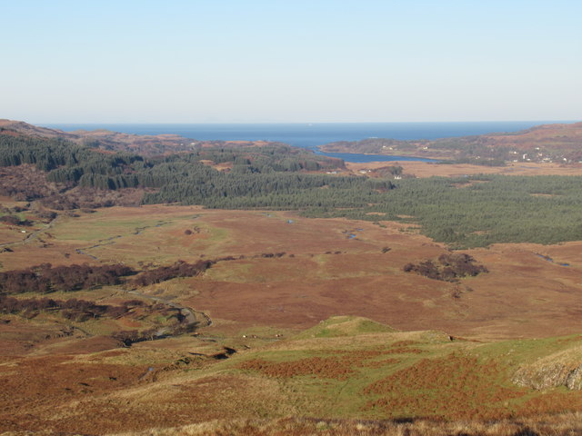
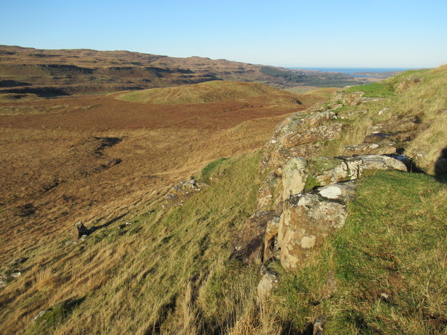
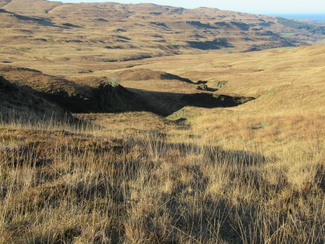
Glac a' Mhadaidh, located in Argyllshire, Scotland, is a stunning glacial valley known as Corrie in Gaelic. Nestled within the majestic landscape of the Scottish Highlands, this geographical marvel captivates visitors with its breathtaking beauty and rich history.

The valley is formed by the slow erosion of a glacier over thousands of years, resulting in a deep, U-shaped valley with steep sides. Glac a' Mhadaidh is characterized by its striking features, including rugged cliffs, sheer rock faces, and cascading waterfalls that add to its dramatic allure.

The valley is known for its diverse flora and fauna, with a variety of plant species thriving in the fertile soil. It is home to an array of wildlife, including red deer, golden eagles, and mountain hares, making it a popular destination for nature enthusiasts and wildlife photographers.

Glac a' Mhadaidh also holds historical significance, with evidence of human activity dating back to ancient times. Archaeological discoveries, such as stone tools and burial sites, indicate that early inhabitants once resided in the region.

Today, Glac a' Mhadaidh attracts hikers and climbers from around the world, who are drawn to its challenging terrain and breathtaking vistas. The valley offers a range of outdoor activities, including trekking, rock climbing, and birdwatching, providing visitors with ample opportunities to immerse themselves in the natural wonders of the Scottish Highlands.

In summary, Glac a' Mhadaidh is a remarkable glacial valley in Argyllshire, Scotland, known for its awe-inspiring scenery, abundant wildlife, and historical significance. It continues to captivate and inspire all who venture into its majestic embrace.

If you have any feedback on the listing, please let us know in the comments section below.

Glac a' Mhadaidh Images

Images are sourced within 2km of 56.534863/-6.1670589 or Grid Reference NM4345. Thanks to Geograph Open Source API. All images are credited.

Glacial scrapings (I think)
Caol-Lochan Caol-Lochan lies in rolling hill country and moorland south-east of Cnoc an dà Chinn. The distant hill is Speinne Mor.
Caol-Lochan
Caol-Lochan lies in rolling hill country and moorland south-east of Cnoc an dà Chinn. The distant hill is Speinne Mor.
Cairn with rocks at summit of Cnoc an dà Chinn Cnoc an dà Chinn is a modest hill north of the east end of Loch Tuath. Ben More is the distant mountain.
Cairn with rocks at summit of Cnoc an dà Chinn
Cnoc an dà Chinn is a modest hill north of the east end of Loch Tuath. Ben More is the distant mountain.
Muddy lochan with peat banks The rather unattractive lochan is located south of Meall na h-Uamhaig, itself a hardly significant location south of the hill of Cnoc an dà Chinn. The view beyond however is very fine with Ben More the highest of the mountains in the image.
Muddy lochan with peat banks
The rather unattractive lochan is located south of Meall na h-Uamhaig, itself a hardly significant location south of the hill of Cnoc an dà Chinn. The view beyond however is very fine with Ben More the highest of the mountains in the image.
Rock outcrops at Coire nan Caorach near Dervaig, Mull Why these amongst hundreds of candidates for rock outcrops should prevail I am answerless - but heyho that's mapping!
Rock outcrops at Coire nan Caorach near Dervaig, Mull
Why these amongst hundreds of candidates for rock outcrops should prevail I am answerless - but heyho that's mapping!
Wee fall on one upper branch of Allt Coille a' Chill' Mhoraire near Dervaig, Mull Why one insignificant fall amongst hundreds of others on this burn is completely explicable - it is visible to the lens! Neither map can/nor lens in today's light could do justice to Allt Coille a' Chill' Mhoraire's falls and gorges!
Wee fall on one upper branch of Allt Coille a' Chill' Mhoraire near Dervaig, Mull
Why one insignificant fall amongst hundreds of others on this burn is completely explicable - it is visible to the lens! Neither map can/nor lens in today's light could do justice to Allt Coille a' Chill' Mhoraire's falls and gorges!
A gorgeous fall in another Coire nan Caorach near Dervaig Again the eye is better than either map or lense at sensing this feature!
A gorgeous fall in another Coire nan Caorach near Dervaig
Again the eye is better than either map or lense at sensing this feature!
Detail of upper fall/gorge in Coire nan Caorach near Dervaig, Mull
Detail of lower fall/gorge in Coire nan Caorach near Dervaig, Mull
Old dyke on Cnoc na Cuairtich near Dervaig
Old dyke on Cnoc na Cuairtich near Dervaig, Mull
Part of Cnoc na Cuairtich near Dervaig, Mull
View north-west off Cnoc na Cuairtich near Dervaig, Mull
Tiny escarpment overlooking Cnoc na Cuairtich near Dervaig, Mull
The course of one of the many tributaries of Allt Coille Cill' a' Mhoraire near Dervaig, Mull
Autumn grassland above Dervaig, Mull Though altitude is meagre these are upland grasses - pasture for cattle fairly much hugs the low areas.
Autumn grassland above Dervaig, Mull
Though altitude is meagre these are upland grasses - pasture for cattle fairly much hugs the low areas.
Faint deer path in grassland above Dervaig, Mull Such tracks criss-cross the ground. Finding one going your way is a real bonus!
Faint deer path in grassland above Dervaig, Mull
Such tracks criss-cross the ground. Finding one going your way is a real bonus!
Burn coming off the back of Stac nan Each near Dervaig, Mull
Show me another place!

Glac a' Mhadaidh is located at Grid Ref: NM4345 (Lat: 56.534863, Lng: -6.1670589)

Unitary Authority: Argyll and Bute

Police Authority: Argyll and West Dunbartonshire

What 3 Words

///dined.stones.acquaint. Near Dervaig, Argyll & Bute

Related Wikis

Torloisk House

Torloisk House (sometimes referred to as Torluck House in 19th century references) on the Isle of Mull, Argyll in Scotland was the family seat held by...

Achleck

Achleck is a small settlement in the north-west of the Isle of Mull in Argyll and Bute, Scotland. == References ==

Eas Fors

Eas Fors is a waterfall on the island of Mull in Scotland. It is situated on the Ardow Burn south of Dervaig. There is another Eas Fors on the Allt an...

Loch Tuath

Loch Tuath (Scottish Gaelic: Loch-a-Tuath) is a sea loch in the Inner Hebrides, Scotland that separates the Isle of Mull and the island of Ulva. Loch Tuath...

Have you been to Glac a' Mhadaidh?

Leave your review of Glac a' Mhadaidh below (or comments, questions and feedback).