Boyton Marshes

Coastal Marsh, Saltings in Suffolk East Suffolk

England

Boyton Marshes

Looking to Dovey's, Havergate Island  The following from: <span class="nowrap"><a title="https://www.gov.uk/government/publications/suffolks-national-nature-reserves/suffolks-national-nature-reserves#orfordness-havergate" rel="nofollow ugc noopener" href="https://www.gov.uk/government/publications/suffolks-national-nature-reserves/suffolks-national-nature-reserves#orfordness-havergate">Link</a><img style="margin-left:2px;" alt="External link" title="External link - shift click to open in new window" src="https://s1.geograph.org.uk/img/external.png" width="10" height="10"/></span>

'Orfordness-Havergate NNR lies just south of Aldeburgh on the Suffolk coast. The site is a large shingle spit separated from the mainland by the River Alde. The site is normally closed during the winter but the National Trust will allow access to large (12 people nd over) pre-booked groups in this period.

Visitors to Havergate Island must pre-book with the Royal Society for the Protection of Birds (RSPB) by telephoning 01728 648281.

Visitors to Orfordness should contact the National Trust for opening times by telephoning 01394 450057.'
Looking to Dovey's, Havergate Island Credit: Roger Jones

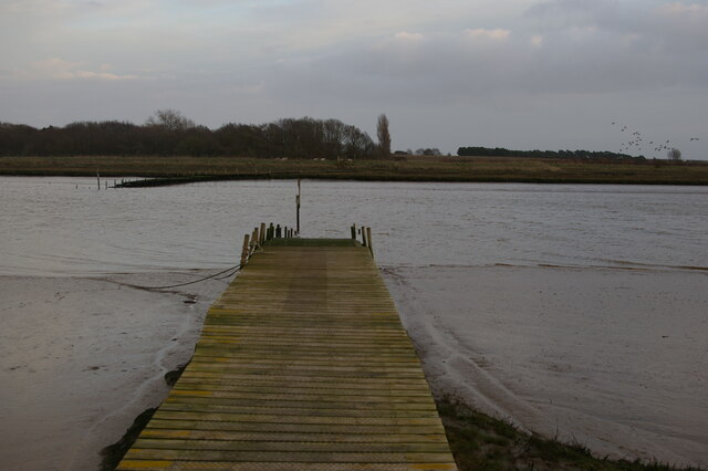
Boyton Marshes is a scenic coastal marshland located in Suffolk, England. Situated on the east coast, it covers an area of approximately 400 acres. The marshes are part of the wider Alde-Ore Estuary and are known for their rich biodiversity and stunning landscapes.

The marshes consist of a mixture of saltmarsh and freshwater marsh, creating a unique and diverse habitat for various plant and animal species. The area is home to a wide range of birds, including wading birds, ducks, and geese. It serves as an important breeding ground for several avian species, such as marsh harriers and reed warblers.

The saltmarsh areas of Boyton Marshes are characterized by their distinct vegetation, composed of salt-tolerant plants like samphire, sea lavender, and sea aster. These plants provide essential food and shelter for numerous invertebrates, which in turn attract a variety of bird species.

Boyton Marshes also boasts an extensive network of ditches and waterways, which support a diverse array of aquatic fauna, including fish, amphibians, and invertebrates. These water channels are essential for managing water levels and maintaining the delicate balance of the marsh ecosystem.

The marshes are not only significant for their ecological value but also serve as a popular destination for nature enthusiasts and birdwatchers. Several walking trails and bird hides have been established to allow visitors to explore and observe the abundant wildlife. The panoramic views of the estuary and the tranquil atmosphere make Boyton Marshes a haven for nature lovers seeking a peaceful and immersive experience in a coastal marshland environment.

If you have any feedback on the listing, please let us know in the comments section below.

Boyton Marshes Images

Images are sourced within 2km of 52.06898/1.4872588 or Grid Reference TM3946. Thanks to Geograph Open Source API. All images are credited.

Looking to Dovey's, Havergate Island  The following from: <span class="nowrap"><a title="https://www.gov.uk/government/publications/suffolks-national-nature-reserves/suffolks-national-nature-reserves#orfordness-havergate" rel="nofollow ugc noopener" href="https://www.gov.uk/government/publications/suffolks-national-nature-reserves/suffolks-national-nature-reserves#orfordness-havergate">Link</a><img style="margin-left:2px;" alt="External link" title="External link - shift click to open in new window" src="https://s1.geograph.org.uk/img/external.png" width="10" height="10"/></span>

'Orfordness-Havergate NNR lies just south of Aldeburgh on the Suffolk coast. The site is a large shingle spit separated from the mainland by the River Alde. The site is normally closed during the winter but the National Trust will allow access to large (12 people nd over) pre-booked groups in this period.

Visitors to Havergate Island must pre-book with the Royal Society for the Protection of Birds (RSPB) by telephoning 01728 648281.

Visitors to Orfordness should contact the National Trust for opening times by telephoning 01394 450057.'
Looking to Dovey's, Havergate Island
The following from: LinkExternal link 'Orfordness-Havergate NNR lies just south of Aldeburgh on the Suffolk coast. The site is a large shingle spit separated from the mainland by the River Alde. The site is normally closed during the winter but the National Trust will allow access to large (12 people nd over) pre-booked groups in this period. Visitors to Havergate Island must pre-book with the Royal Society for the Protection of Birds (RSPB) by telephoning 01728 648281. Visitors to Orfordness should contact the National Trust for opening times by telephoning 01394 450057.'
Looking to Havergate Island, River Ore These pictures are taken from the vessel 'Tilly'. Suffolk River Trips operates boat trips from Orford Quay along the River Ore close to Havergate Island Nature Reserve.

You can book at: <span class="nowrap"><a title="https://www.suffolkrivertrips.com/" rel="nofollow ugc noopener" href="https://www.suffolkrivertrips.com/">Link</a><img style="margin-left:2px;" alt="External link" title="External link - shift click to open in new window" src="https://s1.geograph.org.uk/img/external.png" width="10" height="10"/></span>
Looking to Havergate Island, River Ore
These pictures are taken from the vessel 'Tilly'. Suffolk River Trips operates boat trips from Orford Quay along the River Ore close to Havergate Island Nature Reserve. You can book at: LinkExternal link
River Ore near Flybury Point, looking to Havergate Island These pictures are taken from the vessel 'Tilly'. Suffolk River Trips operates boat trips from Orford Quay along the River Ore close to Havergate Island Nature Reserve.

You can book at: <span class="nowrap"><a title="https://www.suffolkrivertrips.com/" rel="nofollow ugc noopener" href="https://www.suffolkrivertrips.com/">Link</a><img style="margin-left:2px;" alt="External link" title="External link - shift click to open in new window" src="https://s1.geograph.org.uk/img/external.png" width="10" height="10"/></span>
River Ore near Flybury Point, looking to Havergate Island
These pictures are taken from the vessel 'Tilly'. Suffolk River Trips operates boat trips from Orford Quay along the River Ore close to Havergate Island Nature Reserve. You can book at: LinkExternal link
Church of St Andrew, Boyton
Boyton: view down to The Tang, from the Dock Farm corner
Boyton: view north from the corner at Dock Farm Beyond the field in the foreground are Stonebridge Marshes, with the higher ground at Butley beyond this.
Boyton: view north from the corner at Dock Farm
Beyond the field in the foreground are Stonebridge Marshes, with the higher ground at Butley beyond this.
Boyton: the Mary Warner almshouses
Boyton: lane north past Dock Farm
Butley River at Boyton Dock
Butley Ferry, from the west bank A ferry operates here from April to October, rowed by volunteers and carrying pedestrians and cycles.  It forms perhaps the most difficult link in the Suffolk Coast Path.
Butley Ferry, from the west bank
A ferry operates here from April to October, rowed by volunteers and carrying pedestrians and cycles. It forms perhaps the most difficult link in the Suffolk Coast Path.
Butley River, at Butley Ferry
Roadsign near Hayhall Cottages
Boxed in village pump at Boyton Almshouses
Boxed-in village pump at Boyton Almshouses with firebell
Boyton War Memorial The brass plated memorial bears four names from WW1 and one from WW2. However Arthur C.  GROSS who died in 1918 is buried in the churchyard although his name is remembered on the Wickham Market War Memorial.
Boyton War Memorial
The brass plated memorial bears four names from WW1 and one from WW2. However Arthur C. GROSS who died in 1918 is buried in the churchyard although his name is remembered on the Wickham Market War Memorial.
The water pump at the Mary Warner Almshouses, Boyton Until recently the pump was enclosed. viz <a title="https://www.geograph.org.uk/photo/4637494" href="https://www.geograph.org.uk/photo/4637494">Link</a> <a title="https://www.geograph.org.uk/photo/4637497" href="https://www.geograph.org.uk/photo/4637497">Link</a>
The water pump at the Mary Warner Almshouses, Boyton
Until recently the pump was enclosed. viz Link Link
Show me another place!

Boyton Marshes is located at Grid Ref: TM3946 (Lat: 52.06898, Lng: 1.4872588)

Administrative County: Suffolk

District: East Suffolk

Police Authority: Suffolk

What 3 Words

///mandates.moral.quoted. Near Rendlesham, Suffolk

Related Wikis

Butley River

The Butley River or Butley Creek is a tributary of the River Ore in the English county of Suffolk. The river has its source in the Rendlesham Forest area...

Boyton, Suffolk

Boyton is a village and civil parish in the East Suffolk district of Suffolk, England, about eight miles east of Woodbridge, and close to Orford Ness....

Simpson's Saltings

Simpson's Saltings is a 25 hectare nature reserve on the Suffolk coast east of Hollesley. It is managed by the Suffolk Wildlife Trust. It is in the Suffolk...

Gedgrave Hall Pit

Gedgrave Hall Pit is a 0.65-hectare (1.6-acre) geological Site of Special Scientific Interest in Gedgrave, south of Saxmundham in Suffolk. It is a Geological...

Havergate Island

Havergate Island is the only island in the county of Suffolk, England. It is found at the confluence of the River Ore and the Butley River near the village...

Gedgrave

Gedgrave is a civil parish in the East Suffolk district, in the English county of Suffolk in eastern England. In 2005 its population was 30. Gedgrave once...

Capel St Andrew

Capel St Andrew is a village and a civil parish in the East Suffolk district, in the county of Suffolk, England. It is near the larger settlement of Orford...

Butley Priory

Butley Priory, sometimes called Butley Abbey, was a religious house of Canons regular (Augustinians, Black canons) in Butley, Suffolk, dedicated to The...

Nearby Amenities

Located within 500m of 52.06898,1.4872588
Source: PGS
Lat/Long: 52.0724976/1.4904361
Source: PGS
Lat/Long: 52.0718514/1.4920025
Boyton Marshes
Place: locality
Lat/Long: 52.0674734/1.4908946
The data included in this document is from www.openstreetmap.org. The data is made available under ODbL.

Have you been to Boyton Marshes?

Leave your review of Boyton Marshes below (or comments, questions and feedback).