Barrington Point

Coastal Marsh, Saltings in Essex Rochford

England

Barrington Point

One man and his dog Crouch seawall east of Burnham Wick sluice
One man and his dog Credit: John Myers

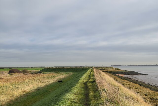
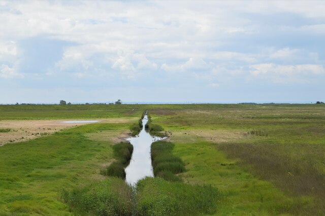
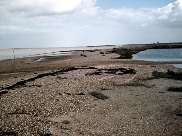
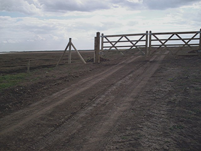
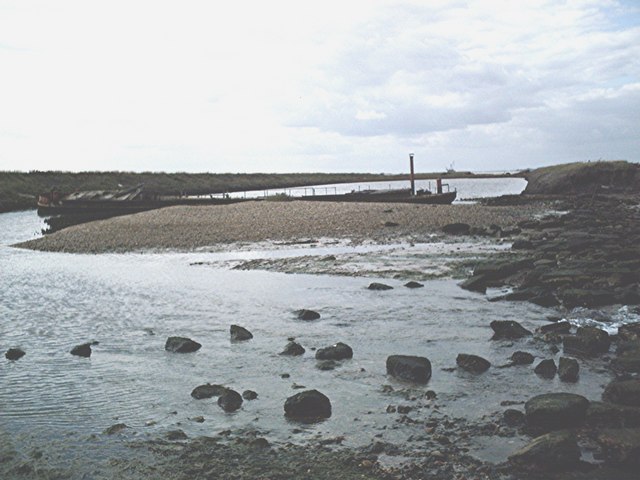
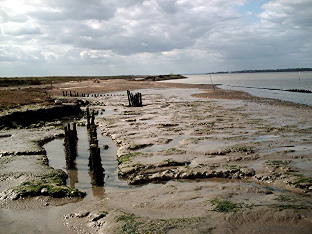
Barrington Point is a picturesque coastal marsh located in Essex, England. It is situated near the mouth of the River Blackwater, where it meets the North Sea. This marshland is known for its stunning natural beauty and unique ecosystem.

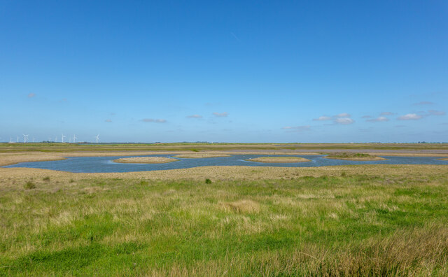
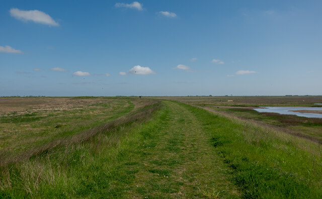
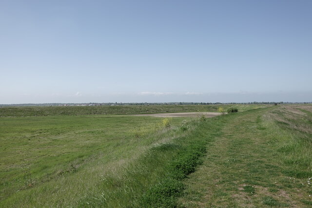
The area is characterized by its vast expanse of salt marshes and saltings, which are large areas of flat land that are regularly flooded by the tides. These marshes are home to a rich variety of plant and animal species, making it an important site for wildlife conservation.

The vegetation in Barrington Point consists mainly of salt-tolerant plants such as samphire, sea lavender, and sea aster. These plants provide essential habitats and food sources for a diverse range of bird species, including waders, ducks, and geese. The marshes also attract migratory birds, which use the area as a stopping point during their long journeys.

In addition to its ecological significance, Barrington Point is a popular destination for outdoor enthusiasts. The area offers opportunities for birdwatching, nature walks, and photography. The vast open skies, expansive views of the estuary, and peaceful atmosphere make it a tranquil and relaxing place to visit.

Overall, Barrington Point is an enchanting coastal marshland that offers a unique glimpse into the natural beauty and biodiversity of the Essex coastline. Whether it is for its ecological importance or its recreational opportunities, this area is a must-visit for nature lovers and those seeking a peaceful retreat in a stunning coastal landscape.

If you have any feedback on the listing, please let us know in the comments section below.

Barrington Point Images

Images are sourced within 2km of 51.616356/0.85592245 or Grid Reference TQ9794. Thanks to Geograph Open Source API. All images are credited.

One man and his dog Crouch seawall east of Burnham Wick sluice
One man and his dog
Crouch seawall east of Burnham Wick sluice
Burnham Wick sluice Pannel's Brook and solar farm
Burnham Wick sluice
Pannel's Brook and solar farm
Land drain heading due south One of the former land drains from the time when this was all sterile arable - now Wallasea RSPB Reserve, seen from the seasonally opened Pools Path.
Land drain heading due south
One of the former land drains from the time when this was all sterile arable - now Wallasea RSPB Reserve, seen from the seasonally opened Pools Path.
Pool, RSPB Wallasea Island Reserve The line of the former land drain can be seen. The RSPB is transforming Wallasea from an area of sterile arable to an invaluable diverse mixed wetland. Taken from the relatively new and seasonally open Pool Path.
Pool, RSPB Wallasea Island Reserve
The line of the former land drain can be seen. The RSPB is transforming Wallasea from an area of sterile arable to an invaluable diverse mixed wetland. Taken from the relatively new and seasonally open Pool Path.
Pool with small islands - RSPB Wallasea Island The following adapted from the RSPB website <span class="nowrap"><a title="https://www.rspb.org.uk/reserves-and-events/reserves-a-z/wallasea-island/" rel="nofollow ugc noopener" href="https://www.rspb.org.uk/reserves-and-events/reserves-a-z/wallasea-island/">Link</a><img style="margin-left:2px;" alt="External link" title="External link - shift click to open in new window" src="https://s1.geograph.org.uk/img/external.png" width="10" height="10"/></span>

"The reserve covers more than 740ha, with all of the arable farmland now transformed to saltmarsh, mudflats, lagoons and grazing marsh.

There are six walking trails – Jubilee Marsh, Allfleets Marsh, Marsh Flats, South Trail, New Pool Trail and Beagle Trail, making over 15km of trail on the reserve. At the ends of Allfleets Marsh trail and Jubilee Marsh trail are two shelters providing a comfortable place to sit overlooking the river.

To create this magical landscape of marshland, lagoons, ditches and sea, more than three million tonnes of earth was brought by boat from the tunnels and shafts created by the Crossrail scheme in London. This allowed us to raise the land above sea level and place the soil in a way that created a new 115-hectare intertidal area of saltmarsh, islands and mudflats (known as Jubilee Marsh).

In addition, Crossrail helped us create saline lagoons, a creek network and grazing marsh. All of which means Wallasea Island is now a wildlife-rich habitat and a great place to visit.

Wallasea Island sits within a Special Protection Area which covers the Crouch and Roach estuaries, and which is special for overwintering waders and wildfowl including Brent Geese. Our work here increases the habitat for these birds both whilst roosting and feeding, as well as creating new grassland areas (wet and dry). The intertidal areas have been designed with climate change in mind, with long shallow slopes from the new seawall providing space for the saltmarsh to creep up as sea levels rise."
Pool with small islands - RSPB Wallasea Island
The following adapted from the RSPB website LinkExternal link "The reserve covers more than 740ha, with all of the arable farmland now transformed to saltmarsh, mudflats, lagoons and grazing marsh. There are six walking trails – Jubilee Marsh, Allfleets Marsh, Marsh Flats, South Trail, New Pool Trail and Beagle Trail, making over 15km of trail on the reserve. At the ends of Allfleets Marsh trail and Jubilee Marsh trail are two shelters providing a comfortable place to sit overlooking the river. To create this magical landscape of marshland, lagoons, ditches and sea, more than three million tonnes of earth was brought by boat from the tunnels and shafts created by the Crossrail scheme in London. This allowed us to raise the land above sea level and place the soil in a way that created a new 115-hectare intertidal area of saltmarsh, islands and mudflats (known as Jubilee Marsh). In addition, Crossrail helped us create saline lagoons, a creek network and grazing marsh. All of which means Wallasea Island is now a wildlife-rich habitat and a great place to visit. Wallasea Island sits within a Special Protection Area which covers the Crouch and Roach estuaries, and which is special for overwintering waders and wildfowl including Brent Geese. Our work here increases the habitat for these birds both whilst roosting and feeding, as well as creating new grassland areas (wet and dry). The intertidal areas have been designed with climate change in mind, with long shallow slopes from the new seawall providing space for the saltmarsh to creep up as sea levels rise."
Jubilee Marsh Trail - RSPB Wallasea Island Looking south, see also:
<a href="https://www.geograph.org.uk/photo/7168017">TQ9693 : Jubilee Marsh Trail - RSPB Wallasea Island</a>
Jubilee Marsh Trail - RSPB Wallasea Island
Jubilee Marsh Trail - RSPB Wallasea Island Looking north, see also:
<a href="https://www.geograph.org.uk/photo/7168015">TQ9793 : Jubilee Marsh Trail - RSPB Wallasea Island</a>
Jubilee Marsh Trail - RSPB Wallasea Island
Land drain on Tillets Marsh A section of one of the dead-straight, north-south land drains which divided up the island prior to the RSPB's "Wild Coast Project. This is one of only a few remaining and the most easterly. Assorted ducks and geese are taking advantage of this less visited part of the island
Land drain on Tillets Marsh
A section of one of the dead-straight, north-south land drains which divided up the island prior to the RSPB's "Wild Coast Project. This is one of only a few remaining and the most easterly. Assorted ducks and geese are taking advantage of this less visited part of the island
Burnham-on-Crouch Boat Remains Just out of Burnham-on-Crouch at Ringwood Bar walking along the coastal path one comes to the first of a series of abandoned rotting boat carcasses. It looked to me like the remains of a Viking longboat which it most certainly was not. Doubtless the wind here would once have propelled the boat along the river Crouch, now it propels the wind turbine, one of many, seen on the horizon. A changing face of industry.
Burnham-on-Crouch Boat Remains
Just out of Burnham-on-Crouch at Ringwood Bar walking along the coastal path one comes to the first of a series of abandoned rotting boat carcasses. It looked to me like the remains of a Viking longboat which it most certainly was not. Doubtless the wind here would once have propelled the boat along the river Crouch, now it propels the wind turbine, one of many, seen on the horizon. A changing face of industry.
River Crouch View from footpath East of Burnham-On-Crouch with Wallasea Island in background.
River Crouch
View from footpath East of Burnham-On-Crouch with Wallasea Island in background.
Wallasea Ness - The Beach Confluence of the Roach and Crouch estuaries. About as far as you can get from any habitation in Essex - by land at least.
Wallasea Ness - The Beach
Confluence of the Roach and Crouch estuaries. About as far as you can get from any habitation in Essex - by land at least.
Ringwood Point Sign on sluice. Dredger in background
Ringwood Point
Sign on sluice. Dredger in background
Ringwood Point - Dredger I don't quite know what's happening here. The land behind the existing sea wall appears to be at least in part being removed and a new sea wall built to the south. The sucker ship and the big dumper obviously have some role in this.
Some 3 months after this picture was taken the sea wall was breached close to this point <a href="https://www.geograph.org.uk/photo/197354">TQ9794 : The Sea Returns</a>, <a href="https://www.geograph.org.uk/photo/196257">TQ9694 : Breaching the Sea Wall</a> and a large area of farmland was returned to the sea. The ships were in fact exchanging soil for "uncontaminated" mud dredged up offshore.
Ringwood Point - Dredger
I don't quite know what's happening here. The land behind the existing sea wall appears to be at least in part being removed and a new sea wall built to the south. The sucker ship and the big dumper obviously have some role in this. Some 3 months after this picture was taken the sea wall was breached close to this point TQ9794 : The Sea Returns, TQ9694 : Breaching the Sea Wall and a large area of farmland was returned to the sea. The ships were in fact exchanging soil for "uncontaminated" mud dredged up offshore.
Saltings - East of Fleet Point The round yellow objects in the middle distance are disused buoys. The dredger at Ringwood Point can be seen in the distance.
Saltings - East of Fleet Point
The round yellow objects in the middle distance are disused buoys. The dredger at Ringwood Point can be seen in the distance.
Gates at end of new sea wall A new sea wall running roughly straight between this point and Grasslands Point is under construction and the area south of the old sea wall is being dug out to provide new salt marsh.
Gates at end of new sea wall
A new sea wall running roughly straight between this point and Grasslands Point is under construction and the area south of the old sea wall is being dug out to provide new salt marsh.
Barge aground - Wallasea Ness Wreck on the beach
Barge aground - Wallasea Ness
Wreck on the beach
Brankfleet Spit River Roach at confluence with Crouch
Brankfleet Spit
River Roach at confluence with Crouch
Land drain Probably the only land drain on Wallasea that isn't straight and doesn't run  north/south.
Land drain
Probably the only land drain on Wallasea that isn't straight and doesn't run north/south.
Show me another place!

Barrington Point is located at Grid Ref: TQ9794 (Lat: 51.616356, Lng: 0.85592245)

Administrative County: Essex

District: Rochford

Police Authority: Essex

What 3 Words

///reckoned.officials.acrobatic. Near Burnham-on-Crouch, Essex

Related Wikis

Wallasea Wetlands

Wallasea Wetlands is a reclaimed wetlands area located in Essex, England. It has been created as part of a government-funded wetlands scheme to halt the...

River Roach

The River Roach is a river that flows entirely through the English county of Essex. It is one of four main streams that originate in the Rayleigh Hills...

Wallasea Island

Wallasea Island lies in Essex, England. It is bounded to the north by the River Crouch, to the south east by the River Roach, and to the west by Paglesham...

Royal Corinthian Yacht Club

The Royal Corinthian Yacht Club is a watersports organisation based at Burnham-on-Crouch, Essex. == History == === Early history === The club was founded...

Saint Mary the Virgin, Foulness Island

Saint Mary the Virgin is a parish of the Church of England on Foulness Island, in Essex, England. Before the 15th century, the island of Foulness was divided...

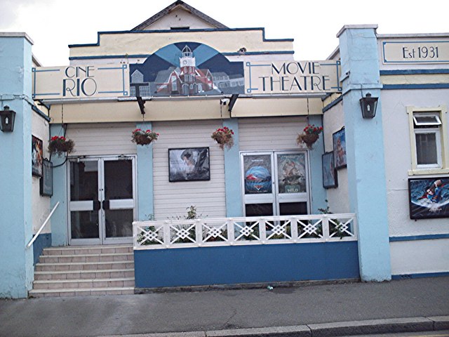
Rio Cinema (Burnham on Crouch)

The Rio Cinema is a purpose-built, two-screen, 280-seat cinema in Burnham on Crouch, Essex in the United Kingdom. The building dates from 1931. The Burnham...

Burnham-on-Crouch & District Museum

The Burnham-on-Crouch and District Museum, located in Burnham-on-Crouch, Essex, is a registered charity run by members of the Burnham History Society,...

Burnham-on-Crouch

Burnham-on-Crouch is a town and civil parish in the Maldon District of Essex, in the East of England; it lies on the north bank of the River Crouch. It...

Nearby Amenities

Located within 500m of 51.616356,0.85592245
Source: PGS
Lat/Long: 51.6129354/0.8521842
Source: PGS
Lat/Long: 51.6125356/0.8540725
Source: PGS
Lat/Long: 51.6122425/0.8562397
Source: PGS
Lat/Long: 51.6155469/0.8597803
Seamark Buoy Lateral Category: starboard
Seamark Buoy Lateral Colour: green
Seamark Buoy Lateral Shape: pillar
Seamark Buoy Lateral System: iala-a
Seamark Light Character: Q
Seamark Light Colour: green
Seamark Light Range: 1.0
Seamark Name: Fairway 1
Seamark Topmark Colour: green
Seamark Topmark Shape: cone, point up
Seamark Type: buoy_lateral
Lat/Long: 51.6182833/0.8513
Seamark Buoy Cardinal Category: north
Seamark Buoy Cardinal Colour: black;yellow
Seamark Buoy Cardinal Colour Pattern: horizontal
Seamark Buoy Cardinal Shape: pillar
Seamark Light Character: Q
Seamark Light Colour: white
Seamark Light Range: 2.0
Seamark Name: Horse Shoal
Seamark Topmark Colour: black
Seamark Topmark Shape: 2 cones up
Seamark Type: buoy_cardinal
Lat/Long: 51.6183667/0.8583333
The data included in this document is from www.openstreetmap.org. The data is made available under ODbL.

Have you been to Barrington Point?

Leave your review of Barrington Point below (or comments, questions and feedback).