Ayre of Kurkigarth

Coastal Marsh, Saltings in Shetland

Scotland

Ayre of Kurkigarth

"Honestas" in Voe Harbour For some reason I assumed this fine boat was permanently moored here, it looks so much part of the scenery.
But it doesn't feature in any other pictures of the harbour so I guess it's a visitor and I was lucky to get this shot.
"Honestas" in Voe Harbour Credit: Des Blenkinsopp

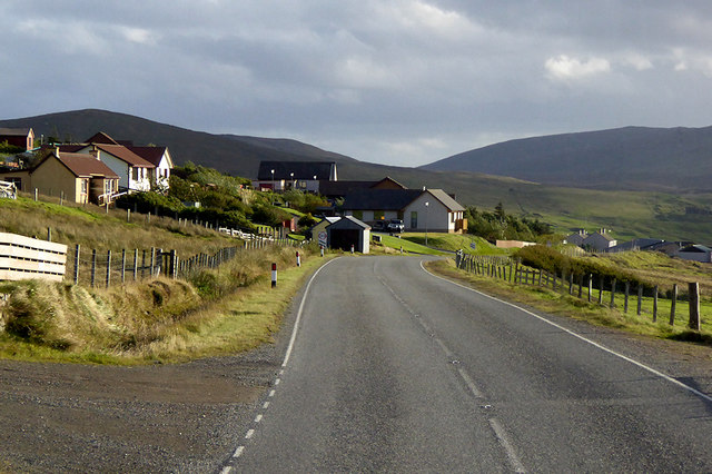
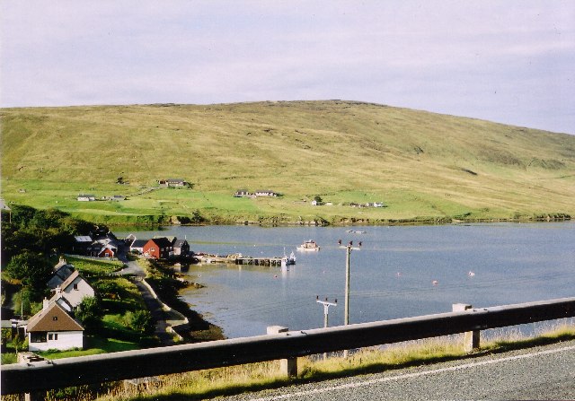
Ayre of Kurkigarth is a coastal marsh located in the Shetland Islands, situated off the northeastern coast of Scotland. It is specifically found in the region of Saltings, near the village of Cunningsburgh. This marshland is characterized by its flat and low-lying terrain, consisting of a mix of salt marshes and mudflats.

The Ayre of Kurkigarth is directly influenced by both the North Sea and the Atlantic Ocean, resulting in a diverse and unique coastal ecosystem. The marshes are regularly flooded by tidal waters, creating a dynamic environment that supports a variety of plant and animal species.

The vegetation within Ayre of Kurkigarth is predominantly salt-tolerant, with plants such as sea lavender, sea aster, and sea purslane thriving in the marshy conditions. These plants play a crucial role in stabilizing the soil and preventing erosion. Additionally, the marshes serve as an important habitat for numerous bird species, including waders like oystercatchers and curlews, as well as migratory birds that visit the area during different seasons.

The Ayre of Kurkigarth is also of archaeological significance, with traces of prehistoric settlements uncovered in the surrounding area. These findings provide valuable insights into the history and human occupation of the region.

Overall, Ayre of Kurkigarth in Shetland is a fascinating coastal marsh characterized by its diverse vegetation, tidal inundation, and significant ecological value.

If you have any feedback on the listing, please let us know in the comments section below.

Ayre of Kurkigarth Images

Images are sourced within 2km of 60.359101/-1.2936462 or Grid Reference HU3964. Thanks to Geograph Open Source API. All images are credited.

"Honestas" in Voe Harbour For some reason I assumed this fine boat was permanently moored here, it looks so much part of the scenery.
But it doesn't feature in any other pictures of the harbour so I guess it's a visitor and I was lucky to get this shot.
"Honestas" in Voe Harbour
For some reason I assumed this fine boat was permanently moored here, it looks so much part of the scenery. But it doesn't feature in any other pictures of the harbour so I guess it's a visitor and I was lucky to get this shot.
Lower Voe The head of Olna Firth, which is frozen.
Lower Voe
The head of Olna Firth, which is frozen.
Frozen marina at Voe Olna Firth is salt water, but is enclosed and has frozen after several days of very hard frosts.
Frozen marina at Voe
Olna Firth is salt water, but is enclosed and has frozen after several days of very hard frosts.
Olna Firth at Voe This sheltered arm of the sea has frozen in the hard frosts of recent nights.
Olna Firth at Voe
This sheltered arm of the sea has frozen in the hard frosts of recent nights.
Houses at Voe A view of houses at Voe
Houses at Voe
A view of houses at Voe
Colourful Housing This is Mulla, nice bright colours against the green hillside.
Colourful Housing
This is Mulla, nice bright colours against the green hillside.
Valley of the Burn of Sursetter The Burn of Sursetter is around 3 kms long and flows into Olna Firth. The conical thing in the foreground is a stack of rusty metal fence posts.
Valley of the Burn of Sursetter
The Burn of Sursetter is around 3 kms long and flows into Olna Firth. The conical thing in the foreground is a stack of rusty metal fence posts.
Overlooking Voe Harbour
Hamars, near Voe One of several farms along the valley
Hamars, near Voe
One of several farms along the valley
Olna Firth, Voe I'm a bit confused as to the difference between a Firth and a Voe, but then I'm from Oxfordshire where there aren't many of either.
Olna Firth, Voe
I'm a bit confused as to the difference between a Firth and a Voe, but then I'm from Oxfordshire where there aren't many of either.
Isles Road, Hamars The A968 is the United Kingdom's northernmost A-road. It is 42 miles long and connects the islands of Yell and Unst to the Shetland Mainland. Travelling the length of the road involves two ferry crossings and the road is actually separated into three sections. The first 10 miles is from the A970 at Voe on the Shetland mainland to the ferry terminal at Toft. The next 17½ miles crosses the island of Yell, running between the ferry terminals at Ulsta and Gutcher. Finally, the road runs for a further 10 miles across Unst from the ferry terminal at Belmont to Haroldswick.
Isles Road, Hamars
The A968 is the United Kingdom's northernmost A-road. It is 42 miles long and connects the islands of Yell and Unst to the Shetland Mainland. Travelling the length of the road involves two ferry crossings and the road is actually separated into three sections. The first 10 miles is from the A970 at Voe on the Shetland mainland to the ferry terminal at Toft. The next 17½ miles crosses the island of Yell, running between the ferry terminals at Ulsta and Gutcher. Finally, the road runs for a further 10 miles across Unst from the ferry terminal at Belmont to Haroldswick.
Hillside, Isles Road (A968) The A968 is the United Kingdom's northernmost A-road. It is 42 miles long and connects the islands of Yell and Unst to the Shetland Mainland. Travelling the length of the road involves two ferry crossings and the road is actually separated into three sections. The first 10 miles is from the A970 at Voe on the Shetland mainland to the ferry terminal at Toft. The next 17½ miles crosses the island of Yell, running between the ferry terminals at Ulsta and Gutcher. Finally, the road runs for a further 10 miles across Unst from the ferry terminal at Belmont to Haroldswick.
Hillside, Isles Road (A968)
The A968 is the United Kingdom's northernmost A-road. It is 42 miles long and connects the islands of Yell and Unst to the Shetland Mainland. Travelling the length of the road involves two ferry crossings and the road is actually separated into three sections. The first 10 miles is from the A970 at Voe on the Shetland mainland to the ferry terminal at Toft. The next 17½ miles crosses the island of Yell, running between the ferry terminals at Ulsta and Gutcher. Finally, the road runs for a further 10 miles across Unst from the ferry terminal at Belmont to Haroldswick.
Marina and pier at Voe At the head of Olna Firth.
Marina and pier at Voe
At the head of Olna Firth.
A970 at Voe The village of Voe is at the head of Olna Firth and is the meeting point of two major (for Shetland) routes. The A970 from Lerwick and the south shifts eastwards here before continuing towards Brae and Northmavine whilst the A968 continues northwards to Mossbank and the ferries to Yell and Unst. Two "B" roads lead west to West Mainland and east to Vidlin. This east side of the firth is also home to much of the new housing that has sprung up since the 1970s oil boom, plus the village shops and other services (<span class="nowrap"><a title="https://www.undiscoveredscotland.co.uk/shetland/voe/index.html" rel="nofollow ugc noopener" href="https://www.undiscoveredscotland.co.uk/shetland/voe/index.html">Link</a><img style="margin-left:2px;" alt="External link" title="External link - shift click to open in new window" src="https://s1.geograph.org.uk/img/external.png" width="10" height="10"/></span>  Undiscovered Scotland).
A970 at Voe
The village of Voe is at the head of Olna Firth and is the meeting point of two major (for Shetland) routes. The A970 from Lerwick and the south shifts eastwards here before continuing towards Brae and Northmavine whilst the A968 continues northwards to Mossbank and the ferries to Yell and Unst. Two "B" roads lead west to West Mainland and east to Vidlin. This east side of the firth is also home to much of the new housing that has sprung up since the 1970s oil boom, plus the village shops and other services (LinkExternal link Undiscovered Scotland).
The Anchorage Bus Stop, A970 at Voe The village of Voe is at the head of Olna Firth and is the meeting point of two major (for Shetland) routes. The A970 from Lerwick and the south shifts eastwards here before continuing towards Brae and Northmavine whilst the A968 continues northwards to Mossbank and the ferries to Yell and Unst. Two "B" roads lead west to West Mainland and east to Vidlin. This east side of the firth is also home to much of the new housing that has sprung up since the 1970s oil boom, plus the village shops and other services (<span class="nowrap"><a title="https://www.undiscoveredscotland.co.uk/shetland/voe/index.html" rel="nofollow ugc noopener" href="https://www.undiscoveredscotland.co.uk/shetland/voe/index.html">Link</a><img style="margin-left:2px;" alt="External link" title="External link - shift click to open in new window" src="https://s1.geograph.org.uk/img/external.png" width="10" height="10"/></span>  Undiscovered Scotland).
The Anchorage Bus Stop, A970 at Voe
The village of Voe is at the head of Olna Firth and is the meeting point of two major (for Shetland) routes. The A970 from Lerwick and the south shifts eastwards here before continuing towards Brae and Northmavine whilst the A968 continues northwards to Mossbank and the ferries to Yell and Unst. Two "B" roads lead west to West Mainland and east to Vidlin. This east side of the firth is also home to much of the new housing that has sprung up since the 1970s oil boom, plus the village shops and other services (LinkExternal link Undiscovered Scotland).
Hillside, Voe Kirk The striking, white church replaced the eighteenth century church, Olnafirth Kirk, which dates back to 1714 and whose ruins lay near to the edge of the firth (<a href="https://www.geograph.org.uk/photo/2998628">HU4063 : Olnafirth Kirk</a>).
Hillside, Voe Kirk
The striking, white church replaced the eighteenth century church, Olnafirth Kirk, which dates back to 1714 and whose ruins lay near to the edge of the firth (HU4063 : Olnafirth Kirk).
Antenna on the Hillside above Voe The A970 runs for 71 miles across most of the length of the "Mainland" in the Shetland Islands. It is a good-quality single-carriageway road for most of its route. Travelling from south to north, the road begins at Grutness near Sumburgh Airport and winds around the many hills and inlets passing close to a number of small villages without going through any large ones before Lerwick. After looping around Lerwick, a short spur runs to Scalloway whilst the main route continues northwards towards Brae where it crosses the narrow isthmus of Mavis Grind. At Sandy Lochs the road splits and a four-mile spur goes through Urafirth to Hillswick. The main route continuing to the right towards its northern terminus at Isbister. This last part of the route tends to be narrower with passing places.

<span class="nowrap"><a title="https://www.sabre-roads.org.uk/wiki/index.php?title=A970" rel="nofollow ugc noopener" href="https://www.sabre-roads.org.uk/wiki/index.php?title=A970">Link</a><img style="margin-left:2px;" alt="External link" title="External link - shift click to open in new window" src="https://s1.geograph.org.uk/img/external.png" width="10" height="10"/></span>  SABRE
Antenna on the Hillside above Voe
The A970 runs for 71 miles across most of the length of the "Mainland" in the Shetland Islands. It is a good-quality single-carriageway road for most of its route. Travelling from south to north, the road begins at Grutness near Sumburgh Airport and winds around the many hills and inlets passing close to a number of small villages without going through any large ones before Lerwick. After looping around Lerwick, a short spur runs to Scalloway whilst the main route continues northwards towards Brae where it crosses the narrow isthmus of Mavis Grind. At Sandy Lochs the road splits and a four-mile spur goes through Urafirth to Hillswick. The main route continuing to the right towards its northern terminus at Isbister. This last part of the route tends to be narrower with passing places. LinkExternal link SABRE
Voe, Olna Firth
Voe, Olna Firth
Show me another place!

Ayre of Kurkigarth is located at Grid Ref: HU3964 (Lat: 60.359101, Lng: -1.2936462)

Unitary Authority: Shetland Islands

Police Authority: Highlands and Islands

What 3 Words

///hydrant.rebounder.glow. Near Brae, Shetland Islands

Related Wikis

Voe, Delting

Voe is a village in Delting parish on Mainland, Shetland, Scotland. It is one of the three main settlements in Delting. It is at the junction of the A968...

Linga, Busta Voe

Linga is a small, uninhabited island, 1 km (0.62 mi) east of Muckle Roe in the Shetland Islands. The island is roughly circular in shape and its highest...

Shetland

Shetland, also called the Shetland Islands and formerly Zetland, is an archipelago in Scotland lying between Orkney, the Faroe Islands, and Norway. It...

Delting

Delting is a civil parish and community council area on Mainland, Shetland, Scotland. It includes the Sullom Voe oil terminal and its main settlements...

Busta Voe

Busta Voe, (HU665350), in the north central Mainland, Shetland, is a sea inlet lying between the village of Brae and the island of Muckle Roe. At the head...

Brae

"Brae" is also the Lowland Scots language word for the slope or brow of a hill.Brae (Old Norse: Breiðeið, meaning "the wide isthmus") is a village on the...

Laxo

Laxo is a small settlement at the end of Laxo Voe in Vidlin, Shetland, Scotland. A ferry from the Mainland to Symbister in Whalsay operates from the nearby...

Papa Little

Papa Little (Scots: Papa Little; Old Norse: Papey Litla, meaning "the little island of the priests") is an island in St Magnus Bay, Shetland, Scotland...

Nearby Amenities

Located within 500m of 60.359101,-1.2936462
Power: pole
Lat/Long: 60.3613641/-1.2864572
Power: pole
Lat/Long: 60.3606585/-1.2863204
Power: pole
Lat/Long: 60.3597087/-1.2861139
Power: pole
Lat/Long: 60.3588518/-1.2856901
Power: pole
Lat/Long: 60.3578489/-1.2851805
The data included in this document is from www.openstreetmap.org. The data is made available under ODbL.

Have you been to Ayre of Kurkigarth?

Leave your review of Ayre of Kurkigarth below (or comments, questions and feedback).