Little Score
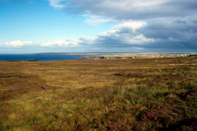
Coastal Marsh, Saltings in Caithness
Scotland
Little Score
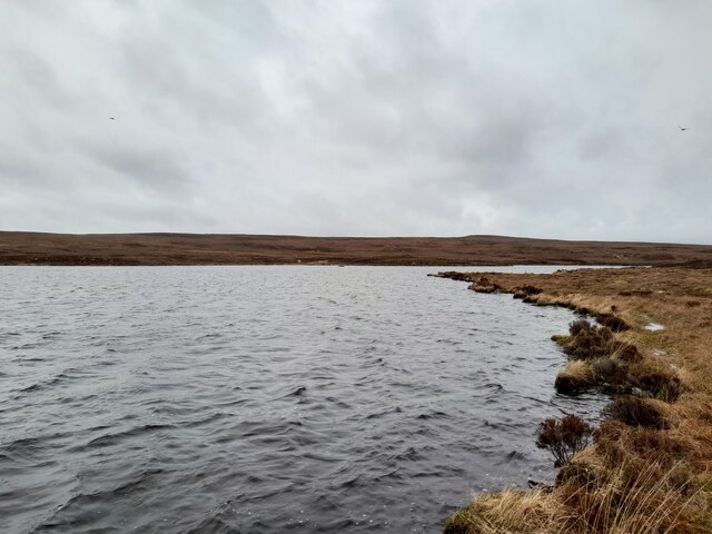
Little Score is a picturesque coastal marsh and saltings located in the county of Caithness, Scotland. Stretching across an area of approximately 10 hectares, this natural reserve is a haven for a diverse range of plant and animal species, making it an important ecological site.
The landscape of Little Score is characterized by its vast expanse of tidal mudflats, salt marshes, and sand dunes. These habitats create a unique environment that supports a variety of specialized flora and fauna. The marshes are dominated by lush grasses, herbs, and sedges, while the muddy areas are home to various types of algae and small invertebrates.
The reserve serves as a crucial breeding ground and feeding site for numerous bird species, making it a popular spot for birdwatchers. It attracts waders such as redshanks, dunlins, and oystercatchers, as well as migratory birds like godwits and curlews. Little Score is also known to host nesting colonies of terns and gulls during the summer months.
The marshland provides an important habitat for a range of invertebrates such as snails, worms, and crabs, which play a vital role in the local ecosystem. Additionally, the dunes and salt marshes provide shelter for a variety of reptiles, amphibians, and small mammals.
In recognition of its ecological significance, Little Score has been designated as a Site of Special Scientific Interest (SSSI). The reserve is managed by a local conservation organization in collaboration with governmental bodies to ensure the preservation of its unique biodiversity.
Visitors to Little Score can enjoy stunning views of the surrounding coastline and observe the abundant wildlife in its natural habitat. The reserve also offers educational opportunities, with guided walks and nature trails available for those interested in learning more about the local ecology.
If you have any feedback on the listing, please let us know in the comments section below.
Little Score Images
Images are sourced within 2km of 58.657048/-3.3518123 or Grid Reference ND2175. Thanks to Geograph Open Source API. All images are credited.


Little Score is located at Grid Ref: ND2175 (Lat: 58.657048, Lng: -3.3518123)
Unitary Authority: Highland
Police Authority: Highlands and Islands
What 3 Words
///allows.barstool.agent. Near Thurso, Highland
Nearby Locations
Related Wikis

Brough Castle (Caithness)
Brough Castle is a ruined castle near Brough, Caithness. It is believed to date from the 12th to 14th centuries. == Description == The foundations of...

Brough, Caithness
Brough is a small village (population 66) in Caithness in the North of Scotland. It is located on the B855 single-track road, the most northerly numbered...

Dunnet Head Lighthouse
Dunnet Head Lighthouse is an active 19th century lighthouse that stands on the 300-foot (91 m) cliff top of Easter Head on Dunnet Head. The lighthouse...

Dunnet Head
Dunnet Head (Scottish Gaelic: Ceann Dùnaid) is a peninsula in Caithness, on the north coast of Scotland. Dunnet Head includes the most northerly point...

Ham, Caithness
Ham is a village in the Caithness region in the Scottish council area of Highland. It has a very short river running from a mill pond to the sea - a total...
Dunnet Church
Dunnet Parish Church is a Church of Scotland church in Dunnet, Caithness, northern Scotland. References to St Mary's Parish Church are known from as far...

Dunnet
Dunnet is a village in Caithness, in the Highland area of Scotland. It is within the Parish of Dunnet. == Village == The village centres on the A836–B855...

Skarfskerry
Skarfskerry (or Scarfskerry; Scottish Gaelic: Sgarbh Sgeir) is a settlement located in the far northern county Caithness on a small peninsula northeast...
Nearby Amenities
Located within 500m of 58.657048,-3.3518123Have you been to Little Score?
Leave your review of Little Score below (or comments, questions and feedback).