Dovecot Neuk

Coastal Marsh, Saltings in Kirkcudbrightshire

Scotland

Dovecot Neuk

Barbour Memorial Hall, Glencaple The Barbour Memorial Hall, on Church Street, was opened in 1938.
Barbour Memorial Hall, Glencaple Credit: David Dixon

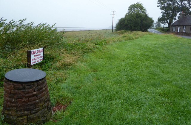
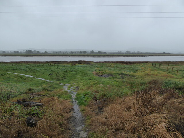
Dovecot Neuk is a small coastal marsh located in Kirkcudbrightshire, Scotland. Situated on the shores of the Solway Firth, this area is characterized by its rich biodiversity and unique habitat.

The marshland at Dovecot Neuk consists of a variety of saltmarsh plants, such as sea lavender, sea purslane, and glasswort. These plants provide important habitat for a wide range of bird species, including waders like curlews, redshanks, and oystercatchers. The area is also home to a number of rare plant species, making it a designated Site of Special Scientific Interest (SSSI).

The marshland at Dovecot Neuk is subject to the ebb and flow of the tides, creating a dynamic and ever-changing landscape. The area is also important for its role in flood protection, as the marshland absorbs excess water and reduces the risk of flooding in nearby communities.

Visitors to Dovecot Neuk can enjoy peaceful walks along the coastal path, observing the diverse flora and fauna that call this area home. The marshland provides a tranquil and picturesque setting, perfect for nature enthusiasts and birdwatchers alike.

If you have any feedback on the listing, please let us know in the comments section below.

Dovecot Neuk Images

Images are sourced within 2km of 55.01095/-3.5786033 or Grid Reference NX9969. Thanks to Geograph Open Source API. All images are credited.

Barbour Memorial Hall, Glencaple The Barbour Memorial Hall, on Church Street, was opened in 1938.
Barbour Memorial Hall, Glencaple
The Barbour Memorial Hall, on Church Street, was opened in 1938.
Cottages at Glencaple Cottages at the corner of Church Street and Shore Road.
Cottages at Glencaple
Cottages at the corner of Church Street and Shore Road.
Small Boat at Glencaple Slipway
Estuary Sunset A sunset view from Glencaple Quay, looking across the River Nith towards the hills on the other side.
Estuary Sunset
A sunset view from Glencaple Quay, looking across the River Nith towards the hills on the other side.
Sunset at Glencaple Quay A sunset view from Glencaple Quay, looking across the River Nith towards the hills on the other side.
Sunset at Glencaple Quay
A sunset view from Glencaple Quay, looking across the River Nith towards the hills on the other side.
Glencaple Sunset A sunset view from Glencaple Quay, looking across the River Nith towards the hills on the other side.
Glencaple Sunset
A sunset view from Glencaple Quay, looking across the River Nith towards the hills on the other side.
RBS Millennium Milepost at Glencaple One of the 1000 cast iron mileposts funded by the Royal Bank of Scotland to mark the creation of the National Cycle Network. This one, next to Glencaple Quay, is on NCN route 7 which runs from Glasgow to Carlisle. 

There are four different designs of milepost in the series. This is an example of the design by Welsh artist, Andrew Rowe. It is based upon the nautical and industrial heritage of his native Swansea and can have up to four directional fingers. 

See <a title="https://www.geograph.org.uk/article/National-Cycle-Network/1" href="https://www.geograph.org.uk/article/National-Cycle-Network/1">Link</a>  for further examples and photos of millennium mileposts throughout the UK.
RBS Millennium Milepost at Glencaple
One of the 1000 cast iron mileposts funded by the Royal Bank of Scotland to mark the creation of the National Cycle Network. This one, next to Glencaple Quay, is on NCN route 7 which runs from Glasgow to Carlisle. There are four different designs of milepost in the series. This is an example of the design by Welsh artist, Andrew Rowe. It is based upon the nautical and industrial heritage of his native Swansea and can have up to four directional fingers. See Link for further examples and photos of millennium mileposts throughout the UK.
Glencaple Junction Glencaple is a small village situated on the banks of the River Nith; it once served as a port for nearby Dumfries. Glencaple is a Gaelic name meaning 'horse valley' from the words gleann 'narrow valley' and capall 'horse, mare' (Wikipedia).

The coastal (B725) road runs through the village; this photograph was taken at its junction with Church Street which is the only other route into the village.
Glencaple Junction
Glencaple is a small village situated on the banks of the River Nith; it once served as a port for nearby Dumfries. Glencaple is a Gaelic name meaning 'horse valley' from the words gleann 'narrow valley' and capall 'horse, mare' (Wikipedia). The coastal (B725) road runs through the village; this photograph was taken at its junction with Church Street which is the only other route into the village.
The Caerlaverock Cairn On the pier at Glencaple overlooking the River Nith, in the rain!
With boats on the mud on the left and cottages of Glencaple on the right.
An image of the plaque on the cairn is on <a title="https://www.geograph.org.uk/photo/4805343" href="https://www.geograph.org.uk/photo/4805343">Link</a>
The Caerlaverock Cairn
On the pier at Glencaple overlooking the River Nith, in the rain! With boats on the mud on the left and cottages of Glencaple on the right. An image of the plaque on the cairn is on Link
Beacon on the pier at Glencaple Overlooking the River Nith.
And the rain poured down!
Beacon on the pier at Glencaple
Overlooking the River Nith. And the rain poured down!
Approaching Glencaple on the River Nith The electricity poles follow the coastline.
Viewed from near the Conheath Cottages.
Approaching Glencaple on the River Nith
The electricity poles follow the coastline. Viewed from near the Conheath Cottages.
The Glencaple road, B725 With the memorial to Angus MacKay on the left.
See details of the memorial on Christine Johnstone's image: <a title="https://www.geograph.org.uk/photo/6388455" href="https://www.geograph.org.uk/photo/6388455">Link</a> 
It is still raining!
The Glencaple road, B725
With the memorial to Angus MacKay on the left. See details of the memorial on Christine Johnstone's image: Link It is still raining!
Low tide on the River Nith
The River Nith at Kelton A convenient path leads between the houses in Kelton down to the river bank.
The River Nith at Kelton
A convenient path leads between the houses in Kelton down to the river bank.
Looking upstream on the River Nith From the village of Kelton.
Looking upstream on the River Nith
From the village of Kelton.
Gatehouse to Conheath 'Conheath is a small, relatively intact designed landscape with the current house dating from the early-19th century. The walled garden probably dates from the 17th century and is now managed as Conheath Nurseries.' <span class="nowrap"><a title="https://www.parksandgardens.org/places/conheath" rel="nofollow ugc noopener" href="https://www.parksandgardens.org/places/conheath">Link</a><img style="margin-left:2px;" alt="External link" title="External link - shift click to open in new window" src="https://s1.geograph.org.uk/img/external.png" width="10" height="10"/></span>
Gatehouse to Conheath
'Conheath is a small, relatively intact designed landscape with the current house dating from the early-19th century. The walled garden probably dates from the 17th century and is now managed as Conheath Nurseries.' LinkExternal link
Gate, gorse and Criffel The gorse seems extra-colourful this year.
Gate, gorse and Criffel
The gorse seems extra-colourful this year.
Dry stone wall and sheep pasture Leading the eye to an unnamed wood east of Howmains.
Dry stone wall and sheep pasture
Leading the eye to an unnamed wood east of Howmains.
Show me another place!

Dovecot Neuk is located at Grid Ref: NX9969 (Lat: 55.01095, Lng: -3.5786033)

Unitary Authority: Dumfries and Galloway

Police Authority: Dumfries and Galloway

What 3 Words

///rural.suits.rock. Near Dumfries, Dumfries & Galloway

Nearby Locations

Dovecot Neuk

Related Wikis

Glencaple

Glencaple is a small settlement in the Dumfries and Galloway area of Scotland. Situated on the banks of the River Nith, it once served as a port for nearby...

River Nith

The River Nith (Scottish Gaelic: Abhainn Nid; Common Brittonic: Nowios) is a river in south-west Scotland. The Nith rises in the Carsphairn hills of East...

Dumfries and Galloway College

Dumfries and Galloway College (Scottish Gaelic: Colaiste Dhùn Phris is Ghall-Ghàidhealaibh) is a further education college in Dumfries and Galloway, with...

Isle Tower

Isle Tower also known as Lochar Tower and Bankend Tower is a 16th-century ruined tower house located in the north of Bankend in Dumfries and Galloway,...

Nearby Amenities

Located within 500m of 55.01095,-3.5786033
Source: PGS
Lat/Long: 55.0066961/-3.5766008
Source: PGS
Lat/Long: 55.0081724/-3.5770521
Source: PGS
Lat/Long: 55.0092224/-3.5774988
Source: PGS
Lat/Long: 55.0099486/-3.5778878
Source: PGS
Lat/Long: 55.010203/-3.5784153
Source: PGS
Lat/Long: 55.0108874/-3.5799571
Source: PGS
Lat/Long: 55.0110965/-3.5798176
Source: PGS
Lat/Long: 55.0112749/-3.5798605
Source: PGS
Lat/Long: 55.0117979/-3.580236
Source: PGS
Lat/Long: 55.0122839/-3.5803433
Source: PGS
Lat/Long: 55.0130426/-3.5802424
Created By: almien_coastlines
Source: PGS
Lat/Long: 55.0134034/-3.5804091
Source: PGS
Lat/Long: 55.0137654/-3.5807079
Created By: almien_coastlines
Source: PGS
Lat/Long: 55.0140323/-3.5808494
Source: PGS
Lat/Long: 55.0143042/-3.5811514
Source: PGS
Lat/Long: 55.0149906/-3.5817273
Source: PGS
Lat/Long: 55.0152674/-3.5778757
Source: PGS
Lat/Long: 55.0149414/-3.5775967
Source: PGS
Lat/Long: 55.0142524/-3.5772105
Source: PGS
Lat/Long: 55.0136803/-3.5768565
Source: PGS
Lat/Long: 55.0131513/-3.576556
Source: PGS
Lat/Long: 55.0127022/-3.5763307
Source: PGS
Lat/Long: 55.0123638/-3.5761162
Source: PGS
Lat/Long: 55.0119024/-3.5759123
Source: PGS
Lat/Long: 55.0116564/-3.5757728
Source: PGS
Lat/Long: 55.0115149/-3.5757192
Source: PGS
Lat/Long: 55.0113303/-3.5756334
Source: PGS
Lat/Long: 55.0110781/-3.5755261
Source: PGS
Lat/Long: 55.0108812/-3.575451
Source: PGS
Lat/Long: 55.0106782/-3.5753222
Source: PGS
Lat/Long: 55.010469/-3.575172
Source: PGS
Lat/Long: 55.0101491/-3.5749896
Source: PGS
Lat/Long: 55.0093862/-3.5747
Source: PGS
Lat/Long: 55.008677/-3.574355
Source: PGS
Lat/Long: 55.008045/-3.574185
Source: PGS
Lat/Long: 55.0073374/-3.574024
Power: pole
Lat/Long: 55.0085383/-3.5738445
Power: pole
Lat/Long: 55.009658/-3.574437
Power: pole
Lat/Long: 55.0107349/-3.574996
Power: pole
Lat/Long: 55.0118781/-3.5756142
Power: pole
Lat/Long: 55.0130125/-3.576217
Power: pole
Lat/Long: 55.0141099/-3.5768043
Power: pole
Lat/Long: 55.0152295/-3.5773993
Power: pole
Lat/Long: 55.0117157/-3.5749496
Power: pole
Lat/Long: 55.0121145/-3.5739707
Power: pole
Lat/Long: 55.0125118/-3.5729996
Power: pole
Lat/Long: 55.0126669/-3.5726235
The data included in this document is from www.openstreetmap.org. The data is made available under ODbL.

Have you been to Dovecot Neuk?

Leave your review of Dovecot Neuk below (or comments, questions and feedback).