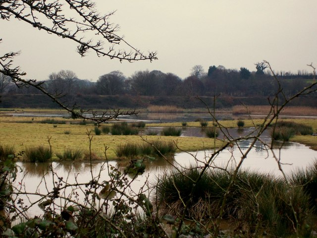
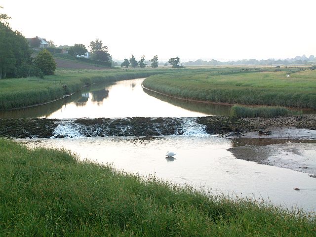
West Mud

Coastal Marsh, Saltings in Devon Teignbridge

England

West Mud

Darts Farm Shopping Village A collection of shops including a really good farm shop and a cafe.
Darts Farm Shopping Village Credit: Sarah Smith

The requested URL returned error: 429 Too Many Requests

If you have any feedback on the listing, please let us know in the comments section below.

West Mud Images

Images are sourced within 2km of 50.670727/-3.4645208 or Grid Reference SX9686. Thanks to Geograph Open Source API. All images are credited.

Darts Farm Shopping Village A collection of shops including a really good farm shop and a cafe.
Darts Farm Shopping Village
A collection of shops including a really good farm shop and a cafe.
Pumpkin time - Darts Farm A fun time for children and their families to pick their own pumpkins!
Pumpkin time - Darts Farm
A fun time for children and their families to pick their own pumpkins!
Pumpkin time (2) - Darts Farm Families enjoying choosing their pumpkins for Halloween.
Pumpkin time (2) - Darts Farm
Families enjoying choosing their pumpkins for Halloween.
The Lighter Inn - Topsham Quay The inn is named after a flat bottomed boat that used to unload the cargo from the larger vessels moored out in the deeper water of the Exe Estuary.
In 1971 the inn was gutted by fire.
The Lighter Inn - Topsham Quay
The inn is named after a flat bottomed boat that used to unload the cargo from the larger vessels moored out in the deeper water of the Exe Estuary. In 1971 the inn was gutted by fire.
The Exe Estuary - Topsham The estuary stretches about eight miles from just south of Exeter down to the English Channel.  The River Clyst also flows in just past Topsham. The area is a protected site and an SSI for the importance of its wading birds. Thousands of different species of water fowl overwinter here and there are different and unusual  species of flora and fauna to be found.
The Exe Estuary - Topsham
The estuary stretches about eight miles from just south of Exeter down to the English Channel. The River Clyst also flows in just past Topsham. The area is a protected site and an SSI for the importance of its wading birds. Thousands of different species of water fowl overwinter here and there are different and unusual species of flora and fauna to be found.
The River Exe - Topsham Looking up the estuary towards Exeter from Topsham Quay.
The River Exe - Topsham
Looking up the estuary towards Exeter from Topsham Quay.
Stern and rudder of the Vigilant- Topsham The Vigilant is an old Thames Barge of 73 tons built in Ipswich in 1904.  It is now being restored at Topsham.  The money did run out but now work has resumed judging by the new planking at the stern.  Notice the thick mud of the estuary!
Stern and rudder of the Vigilant- Topsham
The Vigilant is an old Thames Barge of 73 tons built in Ipswich in 1904. It is now being restored at Topsham. The money did run out but now work has resumed judging by the new planking at the stern. Notice the thick mud of the estuary!
The Exe estuary at Turf Lock, at high tide, lit by the setting sun  The sun's glow is reflected off the houses of Exton on the east bank of the estuary
The Exe estuary at Turf Lock, at high tide, lit by the setting sun
The sun's glow is reflected off the houses of Exton on the east bank of the estuary
Channel for the ferry to Topsham, with riverside buildings lit by the setting sun The River Exe rises on Exmoor and flows south to Exeter and The English Channel. Its estuary is a good example of a Ria (flooded river valley). It is tidal to Countess Wear, just south of Exeter <a href="https://www.geograph.org.uk/photo/1109011">SX9390 : Countess Weir, River Exe</a>. More information <span class="nowrap"><a title="http://en.wikipedia.org/wiki/River_Exe" rel="nofollow ugc noopener" href="http://en.wikipedia.org/wiki/River_Exe">Link</a><img style="margin-left:2px;" alt="External link" title="External link - shift click to open in new window" src="https://s1.geograph.org.uk/img/external.png" width="10" height="10"/></span>
Channel for the ferry to Topsham, with riverside buildings lit by the setting sun
The River Exe rises on Exmoor and flows south to Exeter and The English Channel. Its estuary is a good example of a Ria (flooded river valley). It is tidal to Countess Wear, just south of Exeter SX9390 : Countess Weir, River Exe. More information LinkExternal link
Fallen tree, south of Turf Lock on Exe Estuary On the night of Friday 26th November 2021, Storm Arwen affected much of the UK.  Devon wasn't hit as hard as more northern parts of the country, but this tree by the Exe Valley Way was one of the county's casualties
Fallen tree, south of Turf Lock on Exe Estuary
On the night of Friday 26th November 2021, Storm Arwen affected much of the UK. Devon wasn't hit as hard as more northern parts of the country, but this tree by the Exe Valley Way was one of the county's casualties
View across Exe Estuary to Lympstone Commando Training Centre The tide is rising to cover the nearby Powderham Sand; the white blocks of CTC Lympstone are reflected in the water
View across Exe Estuary to Lympstone Commando Training Centre
The tide is rising to cover the nearby Powderham Sand; the white blocks of CTC Lympstone are reflected in the water
Avocet line railway at Exton and Exe estuary View from the platform of Exton station towards Mount Howe at Topsham and the mouth of the River Clyst
Avocet line railway at Exton and Exe estuary
View from the platform of Exton station towards Mount Howe at Topsham and the mouth of the River Clyst
Train passing through Exton station by Exe estuary The trains from Exmouth run every half-hour, but only alternate ones can stop at Exton station.  The train passing through the station at midday does not stop.
Train passing through Exton station by Exe estuary
The trains from Exmouth run every half-hour, but only alternate ones can stop at Exton station. The train passing through the station at midday does not stop.
Rainbow over hotel and canal basin, Turf Lock, Exeter Canal Built in the 1560, this is one of the oldest canals in Britain. It was built to allow the port of Exeter access to the sea, bypassing the Quay downstream at Topsham. <span class="nowrap"><a title="http://en.wikipedia.org/wiki/Exeter_Ship_Canal" rel="nofollow ugc noopener" href="http://en.wikipedia.org/wiki/Exeter_Ship_Canal">Link</a><img style="margin-left:2px;" alt="External link" title="External link - shift click to open in new window" src="https://s1.geograph.org.uk/img/external.png" width="10" height="10"/></span>
Rainbow over hotel and canal basin, Turf Lock, Exeter Canal
Built in the 1560, this is one of the oldest canals in Britain. It was built to allow the port of Exeter access to the sea, bypassing the Quay downstream at Topsham. LinkExternal link
Pub Sign in Topsham A view of the pub sign of the Lighter Inn on the quay at Topsham in Devon. The pub is in the Hall & Woodhouse group.
Pub Sign in Topsham
A view of the pub sign of the Lighter Inn on the quay at Topsham in Devon. The pub is in the Hall & Woodhouse group.
Railway bridge over the River Clyst
Old boats on the mudbanks of the River Clyst
Narrow street in Topsham
Show me another place!

West Mud is located at Grid Ref: SX9686 (Lat: 50.670727, Lng: -3.4645208)

Administrative County: Devon

District: Teignbridge

Police Authority: Devon and Cornwall

What 3 Words

///stow.acute.crown. Near Topsham, Devon

Nearby Locations

West Mud

Related Wikis

Exeter Ship Canal

The Exeter Ship Canal, also known as the Exeter Canal is a canal leading from (and beside) the River Exe to Exeter Quay in the city of Exeter, Devon, England...

RSPB Bowling Green Marsh

Bowling Green Marsh is a nature reserve located on the confluence of the River Exe (at the top end of its estuary) and the River Clyst, near the town of...

River Clyst

The River Clyst is a river of Devon, England. The name derives from Old English, and translates as Clean-stream (the Welsh name of Clydach, has similar...

Avocet Line

The Avocet Line is the railway line in Devon, England connecting Exeter with Exmouth. It was originally built by the London and South Western Railway,...

Nearby Amenities

Located within 500m of 50.670727,-3.4645208
Source: PGS
Lat/Long: 50.6674776/-3.4676409
Source: PGS
Lat/Long: 50.6684704/-3.4673834
Source: PGS
Lat/Long: 50.6713535/-3.467716
Source: PGS
Lat/Long: 50.6719314/-3.4675122
Bench
Backrest: yes
Lat/Long: 50.6675483/-3.4685127
Life Ring
Emergency: life_ring
Survey Date: 2023-01-02
Lat/Long: 50.6712392/-3.4686188
The data included in this document is from www.openstreetmap.org. The data is made available under ODbL.

Have you been to West Mud?

Leave your review of West Mud below (or comments, questions and feedback).