Broad Ooze

Coastal Marsh, Saltings in Devon South Hams

England

Broad Ooze

The water tower at Butts Park, Newton Ferrers
The water tower at Butts Park, Newton Ferrers Credit: David Smith

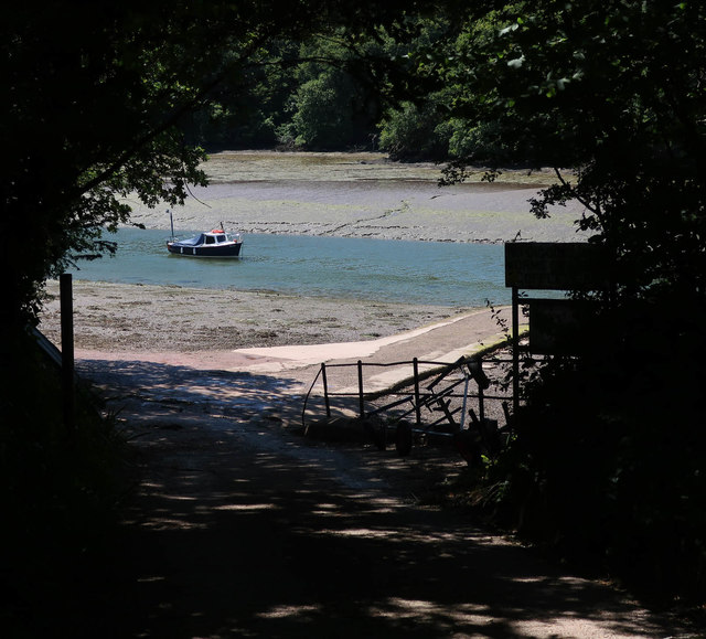
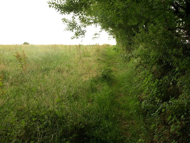
Broad Ooze is a coastal marsh located in Devon, England. It is known for its vast saltings, which are areas of coastal land that are regularly flooded by the tides. The marsh is situated along the banks of the River Exe, near the village of Lympstone.

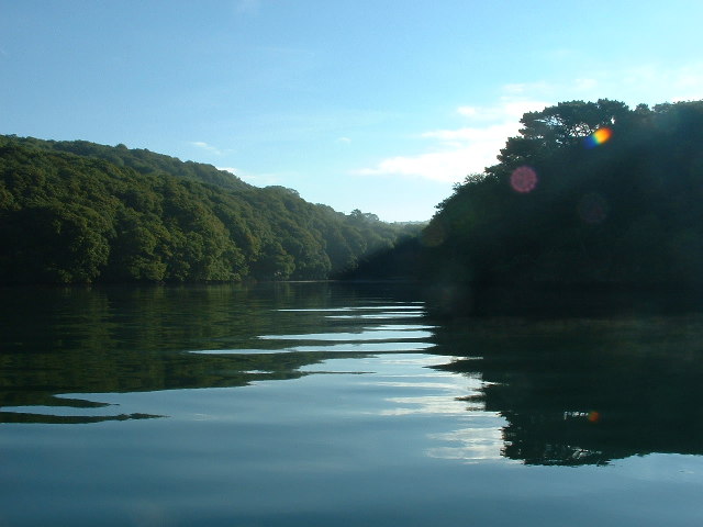
The landscape of Broad Ooze is characterized by a unique blend of saltmarsh and mudflats. It is an important habitat for a wide variety of plant and animal species, including salt-tolerant grasses, samphire, and sea lavender. These plants provide an important food source for numerous bird species, such as curlews, redshanks, and oystercatchers, which can be spotted throughout the marsh.

The marsh is also home to various marine creatures, including crabs, shrimps, and small fish, which thrive in the shallow waters and muddy areas. These invertebrates attract larger predators like herons and egrets, which can often be seen wading through the marsh, searching for their next meal.

Broad Ooze is not only a haven for wildlife but also offers stunning views and picturesque landscapes. The marsh is a popular destination for nature enthusiasts and birdwatchers, who can explore the area via a network of footpaths and observation points. Additionally, the marsh is part of a larger nature reserve, providing protection to the delicate ecosystem and ensuring the preservation of this important coastal habitat.

Overall, Broad Ooze in Devon is a beautiful and ecologically diverse coastal marsh, offering visitors a unique opportunity to experience and appreciate the wonders of nature.

If you have any feedback on the listing, please let us know in the comments section below.

Broad Ooze Images

Images are sourced within 2km of 50.33663/-4.0363201 or Grid Reference SX5550. Thanks to Geograph Open Source API. All images are credited.

The water tower at Butts Park, Newton Ferrers
Road at Steer Point The last 30 metres of the roadway from Brixton is private. It ends at a slipway into Cofflete Creek. Across the creek is Wembury Wood. The sign reads "No digging for worms or fishing. Cofflete B C" . That must be Cofflete Boat Club.
Road at Steer Point
The last 30 metres of the roadway from Brixton is private. It ends at a slipway into Cofflete Creek. Across the creek is Wembury Wood. The sign reads "No digging for worms or fishing. Cofflete B C" . That must be Cofflete Boat Club.
Electricity substation near Newton Ferrers Seen from a gateway on the lane past Wrescombe.
Electricity substation near Newton Ferrers
Seen from a gateway on the lane past Wrescombe.
Cofflete Creek Private slipway at Steer Point
Cofflete Creek
Private slipway at Steer Point
Boathouse at Steer point, Yealm Estuary
Houses at Thorn, Wembury. Yealm Estuary.
Shallowford Creek (aka Shortaflete Creek)
Crawl Woods, Newton Ferrors Looking south easterly across the River Yealm - which lies somewhere 'deep in the valley' between the foreground fields and the distant woods - the telephone cables can clearly be seen following a 'cut' up through Crawl Woods.
Crawl Woods, Newton Ferrors
Looking south easterly across the River Yealm - which lies somewhere 'deep in the valley' between the foreground fields and the distant woods - the telephone cables can clearly be seen following a 'cut' up through Crawl Woods.
Field near Wrescombe The little stream reaches the Yealm estuary less than a kilometre behind the camera; here it follows the foot of a steep field rising towards Collaton Park.
Field near Wrescombe
The little stream reaches the Yealm estuary less than a kilometre behind the camera; here it follows the foot of a steep field rising towards Collaton Park.
Newton Downs An equestrian centre based at a farm just outside Newton Ferrers, set in the Shortaflete valley which runs down to the nearby River Yealm estuary. Seen from the lane to Wrescombe.
Newton Downs
An equestrian centre based at a farm just outside Newton Ferrers, set in the Shortaflete valley which runs down to the nearby River Yealm estuary. Seen from the lane to Wrescombe.
Footpath near Newton Downs Newton and Noss Footpath 4 follows the edge of this field towards the B3186.
Footpath near Newton Downs
Newton and Noss Footpath 4 follows the edge of this field towards the B3186.
Footpath by a Field of Oats This is a new permissive footpath which runs down from the road at Knighton and through Wembury Woods on the banks of the Cofflete Creek.
Footpath by a Field of Oats
This is a new permissive footpath which runs down from the road at Knighton and through Wembury Woods on the banks of the Cofflete Creek.
Butts Park Water Tower An imposing structure by the side of the road leading in to the village.
Butts Park Water Tower
An imposing structure by the side of the road leading in to the village.
Junction at Newton Downs Access to the local riding school.
Junction at Newton Downs
Access to the local riding school.
Butts Park football Pitch Bathed in a late summer's sunshine.
Butts Park football Pitch
Bathed in a late summer's sunshine.
Butts Park
Butts Park
Shortaflete Creek Seen from Newton and Noss Footpath 41 which ends here, although permissive paths continue to allow a circuit of Newton Wood (owned by the Woodland Trust), behind the camera. This is a small side creek of the Yealm estuary. Crawl Wood is on the other side. These are predominantly oak woods.
Shortaflete Creek
Seen from Newton and Noss Footpath 41 which ends here, although permissive paths continue to allow a circuit of Newton Wood (owned by the Woodland Trust), behind the camera. This is a small side creek of the Yealm estuary. Crawl Wood is on the other side. These are predominantly oak woods.
Lane below Wrescombe The lane between Puslinch and Newton Downs twists down to cross a small tributary of the Yealm.
Lane below Wrescombe
The lane between Puslinch and Newton Downs twists down to cross a small tributary of the Yealm.
Show me another place!

Broad Ooze is located at Grid Ref: SX5550 (Lat: 50.33663, Lng: -4.0363201)

Administrative County: Devon

District: South Hams

Police Authority: Devon and Cornwall

What 3 Words

///appear.prospered.dude. Near Brixton, Devon

Related Wikis

Steer Point railway station

Steer Point railway station served the village of Brixton, Devon, England, from 1898 to 1960 on the Plymouth to Yealmpton Branch. == History == The station...

Brixton, Devon

Brixton is a village, parish and former manor situated near Plymouth in South Hams, Devon, England. It is located on the A379 Plymouth to Kingsbridge road...

Combe, Yealmpton, Devon

Combe is a village near Yealmpton in the county of Devon, England. == References ==

Puslinch, Devon

Puslinch is a small but ancient rural locality to the south of Yealmpton village in the South Hams district of the county of Devon, England. The name Puslich...

Nearby Amenities

Located within 500m of 50.33663,-4.0363201
Source: PGS
Lat/Long: 50.3345259/-4.0422244
Source: PGS
Lat/Long: 50.3354552/-4.0420006
Source: PGS
Lat/Long: 50.335632/-4.0420423
Source: PGS
Lat/Long: 50.3361228/-4.0420684
Source: PGS
Lat/Long: 50.335893/-4.0413269
Created By: almien_coastlines
Source: PGS
Lat/Long: 50.33571/-4.0410251
Source: PGS
Lat/Long: 50.3356654/-4.0406858
Source: PGS
Lat/Long: 50.3357828/-4.0403532
Source: PGS
Lat/Long: 50.3360163/-4.0404276
Created By: almien_coastlines
Source: PGS
Lat/Long: 50.3363017/-4.0394115
Source: PGS
Lat/Long: 50.3364661/-4.0393989
Source: PGS
Lat/Long: 50.3373472/-4.0393568
Source: PGS
Lat/Long: 50.3381022/-4.0390479
Source: PGS
Lat/Long: 50.3383544/-4.0387604
Source: PGS
Lat/Long: 50.3385589/-4.0384812
Source: PGS
Lat/Long: 50.3388527/-4.0378983
Source: PGS
Lat/Long: 50.3395663/-4.0371424
Source: PGS
Lat/Long: 50.3398555/-4.0369109
Source: PGS
Lat/Long: 50.3406136/-4.0359068
Source: PGS
Lat/Long: 50.3409218/-4.0353648
Source: PGS
Lat/Long: 50.3409906/-4.0349456
Source: PGS
Lat/Long: 50.3354077/-4.0298098
Steer Point
Historic Railway: station
Railway: site
Wikidata: Q104859443
Wikipedia: en:Steer Point railway station
Lat/Long: 50.3372766/-4.0403895
Ruined Bridge
Historic: ruins
Lat/Long: 50.3392344/-4.0324308
Cylinder Bridge
Historic: ruins
Lat/Long: 50.3392768/-4.0367322
Barrier: stile
Material: wood
Stile: stepover
Lat/Long: 50.3400478/-4.0369803
The data included in this document is from www.openstreetmap.org. The data is made available under ODbL.

Have you been to Broad Ooze?

Leave your review of Broad Ooze below (or comments, questions and feedback).