The Marsh

Coastal Marsh, Saltings in Cornwall

England

The Marsh

Eastbound A38 near Burraton Blue signs giving advance notice of toll charges on the Tamar Bridge ahead (although traffic will have to negotiate the Saltash Tunnel before reaching the bridge).
Eastbound A38 near Burraton Credit: David Dixon

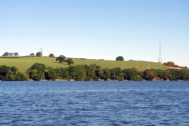
The Marsh, Cornwall, also known as the Coastal Marsh or Saltings, is a significant natural feature located in the southwestern part of England. Situated in the county of Cornwall, this marshland is located near the coast, making it a unique and valuable ecosystem.

The Marsh is characterized by its low-lying, wetland environment, which is partially submerged by seawater during high tides. This dynamic coastal marsh is a mix of salt marshes, mudflats, and sand dunes, creating a diverse habitat for a variety of plant and animal species.

The vegetation in this marshland is adapted to the saline conditions, with plants such as saltmarsh grasses, samphire, and sea lavender thriving in the nutrient-rich mud. These plants not only provide essential habitat and food sources for numerous bird species but also contribute to stabilizing the marshland.

The Marsh is a haven for various bird species, attracting both resident and migratory birds. The mudflats and marshes provide an abundant food supply, making it an ideal feeding ground for wading birds like curlews, herons, and avocets. Additionally, the marshes serve as nesting sites for birds like marsh harriers and reed buntings.

In addition to its ecological significance, The Marsh is also valued for its recreational and educational opportunities. Visitors can explore the marshland on foot, observing the diverse wildlife and taking in the beautiful coastal scenery. The marsh also offers opportunities for birdwatching, photography, and nature study.

The Marsh, Cornwall, with its unique coastal habitat, rich biodiversity, and recreational opportunities, stands as a significant natural area that contributes to the ecological and cultural heritage of Cornwall.

If you have any feedback on the listing, please let us know in the comments section below.

The Marsh Images

Images are sourced within 2km of 50.42858/-4.2271239 or Grid Reference SX4161. Thanks to Geograph Open Source API. All images are credited.

Eastbound A38 near Burraton Blue signs giving advance notice of toll charges on the Tamar Bridge ahead (although traffic will have to negotiate the Saltash Tunnel before reaching the bridge).
Eastbound A38 near Burraton
Blue signs giving advance notice of toll charges on the Tamar Bridge ahead (although traffic will have to negotiate the Saltash Tunnel before reaching the bridge).
Westbound A38 at Carkeel The A38 is a major A-class trunk route. When first designated in 1922, it ran from Derby to Plymouth but it was later extended at both ends so that it now runs for 292 miles from Mansfield in Nottinghamshire to Bodmin in Cornwall.

Prior to the opening of the M5 motorway in the 1960s and 1970s, the A38 formed the main "holiday route" from the Midlands to Somerset, Devon and Cornwall and the south-western section was notorious at holiday times for the congestion. Nowadays, for most of the southern section, the A38 is a fairly quiet road shadowing the M5 extremely closely; often running alongside the motorway as a single carriageway road. The section between Exeter and Plymouth is, however, a busy dual carriageway which serves as the southern extension of the M5 and is known as “the Devon Expressway”.

More information at <span class="nowrap"><a title="http://en.wikipedia.org/wiki/A38_road" rel="nofollow ugc noopener" href="http://en.wikipedia.org/wiki/A38_road">Link</a><img style="margin-left:2px;" alt="External link" title="External link - shift click to open in new window" src="https://s1.geograph.org.uk/img/external.png" width="10" height="10"/></span>  (Wikipedia) and <span class="nowrap"><a title="http://www.sabre-roads.org.uk/wiki/index.php?title=A38" rel="nofollow ugc noopener" href="http://www.sabre-roads.org.uk/wiki/index.php?title=A38">Link</a><img style="margin-left:2px;" alt="External link" title="External link - shift click to open in new window" src="https://s1.geograph.org.uk/img/external.png" width="10" height="10"/></span>  (SABRE).
Westbound A38 at Carkeel
The A38 is a major A-class trunk route. When first designated in 1922, it ran from Derby to Plymouth but it was later extended at both ends so that it now runs for 292 miles from Mansfield in Nottinghamshire to Bodmin in Cornwall. Prior to the opening of the M5 motorway in the 1960s and 1970s, the A38 formed the main "holiday route" from the Midlands to Somerset, Devon and Cornwall and the south-western section was notorious at holiday times for the congestion. Nowadays, for most of the southern section, the A38 is a fairly quiet road shadowing the M5 extremely closely; often running alongside the motorway as a single carriageway road. The section between Exeter and Plymouth is, however, a busy dual carriageway which serves as the southern extension of the M5 and is known as “the Devon Expressway”. More information at LinkExternal link (Wikipedia) and LinkExternal link (SABRE).
'Firestorm' off Skinham Point The yacht plods gently downstream along the River Tamar north of Saltash.
'Firestorm' off Skinham Point
The yacht plods gently downstream along the River Tamar north of Saltash.
River Tamar, near Landulph Looking from the water to the bank on the Cornish side between Neal Point and Weir Point.
River Tamar, near Landulph
Looking from the water to the bank on the Cornish side between Neal Point and Weir Point.
St Mary's Church
St Mary's Church
Former Botus Fleming Wesleyan Chapel
Saltash Travelodge
Saltash Travelodge
China Fleet Country Club, Saltash China Fleet Country Club, Saltash, Cornwall, a replacement for the China Fleet Club in Hong Kong.
China Fleet Country Club, Saltash
China Fleet Country Club, Saltash, Cornwall, a replacement for the China Fleet Club in Hong Kong.
Tamar View Nurseries, Carkeel, Saltash Tamar View Nurseries, on the A388 at Carkeel, near Saltash.
Tamar View Nurseries, Carkeel, Saltash
Tamar View Nurseries, on the A388 at Carkeel, near Saltash.
A388, Carkeel, Saltash The junction from Carkeel village onto the busy A388 Saltash to Callington road. Plenty of overhead cables to be seen!
A388, Carkeel, Saltash
The junction from Carkeel village onto the busy A388 Saltash to Callington road. Plenty of overhead cables to be seen!
Milestone, A388, Carkeel, Saltash Milestone, located on the A388 at the Saltash side of Carkeel. The distance on the stone has been written in Roman numerals - it is 2 miles to Saltash, not 11!
Milestone, A388, Carkeel, Saltash
Milestone, located on the A388 at the Saltash side of Carkeel. The distance on the stone has been written in Roman numerals - it is 2 miles to Saltash, not 11!
Carkeel Roundabout, Saltash Carkeel Roundabout, Saltash, at the junction of the A38 (one of the 2 main routes from Devon into Cornwall) and the A388 Saltash to Callington road. The white van on the left is about to head eastwards onto the A38 leading to the Saltash Tunnel (<a href="https://www.geograph.org.uk/photo/66873">SX4259 : Saltash Tunnel (West Portal)</a>) and Saltash Road Bridge.
Carkeel Roundabout, Saltash
Carkeel Roundabout, Saltash, at the junction of the A38 (one of the 2 main routes from Devon into Cornwall) and the A388 Saltash to Callington road. The white van on the left is about to head eastwards onto the A38 leading to the Saltash Tunnel (SX4259 : Saltash Tunnel (West Portal)) and Saltash Road Bridge.
Neal Point, Landulph View looking south east across the Tamar from the beach
Neal Point, Landulph
View looking south east across the Tamar from the beach
Junction, West Kingsmill, near Saltash Junction, West Kingsmill, near Saltash, Cornwall, with roads leading to Saltash & Callington (left), Cargreen & Landulph (right), and Botus Fleming (out of shot bottom right of picture) up a 1 in 4 (25%) hill.
Junction, West Kingsmill, near Saltash
Junction, West Kingsmill, near Saltash, Cornwall, with roads leading to Saltash & Callington (left), Cargreen & Landulph (right), and Botus Fleming (out of shot bottom right of picture) up a 1 in 4 (25%) hill.
Landulph Cross, near Saltash Landulph Cross, near Saltash. The shadow of the actual cross can be seen on the end of the building just to the right of the orange door. The building next to it is the old smithy.
Landulph Cross, near Saltash
Landulph Cross, near Saltash. The shadow of the actual cross can be seen on the end of the building just to the right of the orange door. The building next to it is the old smithy.
Landulph Methodist Church Landulph Methodist Church, on the Cargeen road from Landulph Cross, near Saltash, Cornwall.
Landulph Methodist Church
Landulph Methodist Church, on the Cargeen road from Landulph Cross, near Saltash, Cornwall.
Fisherwoman at Moditonham Quay Moditonham Quay, near Botusfleming lies on a tributary of the River Tamar, north of Saltash, Cornwall.
Fisherwoman at Moditonham Quay
Moditonham Quay, near Botusfleming lies on a tributary of the River Tamar, north of Saltash, Cornwall.
Top of Kingsmill Lake, near Saltash This is the view of the top of Kingsmill Lake, a tributary of the River Tamar, taken from Moditonham Quay, near Saltash, Cornwall.
Top of Kingsmill Lake, near Saltash
This is the view of the top of Kingsmill Lake, a tributary of the River Tamar, taken from Moditonham Quay, near Saltash, Cornwall.
Show me another place!

The Marsh is located at Grid Ref: SX4161 (Lat: 50.42858, Lng: -4.2271239)

Unitary Authority: Cornwall

Police Authority: Devon and Cornwall

What 3 Words

///succumbs.warriors.chose. Near Saltash, Cornwall

Nearby Locations

The Marsh Moditonham House

Related Wikis

Carkeel

Carkeel is a hamlet north of Saltash in southeast Cornwall, England. == References ==

Landulph

Landulph (Cornish: Lanndhylyk) is a hamlet and a rural civil parish in south-east Cornwall, England, United Kingdom. It is about 3 miles (5 km) north of...

Botusfleming

Botus Fleming or Botusfleming (Cornish: Bosflumyes) is a village and civil parish in southeast Cornwall, England, United Kingdom. The 2001 census gives...

South Pill

South Pill is a suburb of Saltash in the civil parish of Saltash, east Cornwall, England, the word "pill" deriving from a tidal pool related to the estuary...

Nearby Amenities

Located within 500m of 50.42858,-4.2271239
Source: PGS
Lat/Long: 50.4265074/-4.22408
Source: PGS
Lat/Long: 50.4270019/-4.2244429
Source: PGS
Lat/Long: 50.4272029/-4.2250378
Source: PGS
Lat/Long: 50.4276314/-4.2268655
Source: PGS
Lat/Long: 50.4277468/-4.2271876
Source: PGS
Lat/Long: 50.4278016/-4.2276092
Source: PGS
Lat/Long: 50.4279282/-4.2277318
Source: PGS
Lat/Long: 50.4261433/-4.2219248
Source: PGS
Lat/Long: 50.4260705/-4.2218377
Power: pole
Lat/Long: 50.4245848/-4.2294252
Power: pole
Lat/Long: 50.4259399/-4.2293957
Power: pole
Lat/Long: 50.4283424/-4.2292777
Power: pole
Lat/Long: 50.4272437/-4.2293072
Power: pole
Lat/Long: 50.4267781/-4.2293353
Power: pole
Lat/Long: 50.4306524/-4.2309835
Power: pole
Lat/Long: 50.4315922/-4.2316675
Power: pole
Lat/Long: 50.4295983/-4.2301789
The data included in this document is from www.openstreetmap.org. The data is made available under ODbL.

Have you been to The Marsh?

Leave your review of The Marsh below (or comments, questions and feedback).