Dowhill Port

Coastal Marsh, Saltings in Ayrshire

Scotland

Dowhill Port

Foreshore at Drumbeg The Foreshore near Drumbeg.
Foreshore at Drumbeg Credit: Colin Kinnear

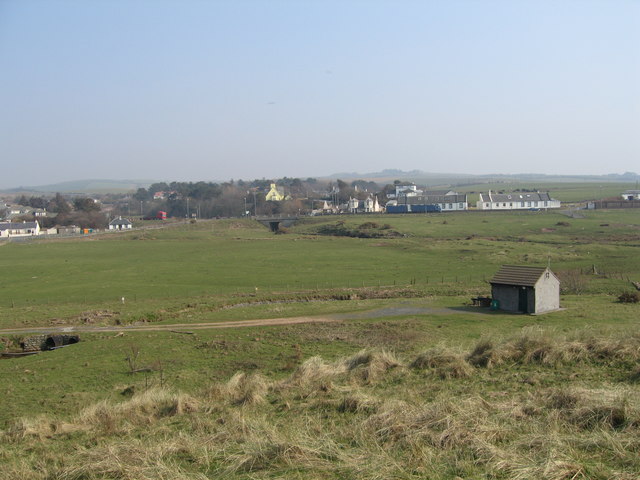
Dowhill Port is a coastal marsh area located in Ayrshire, Scotland. Situated near the town of Troon, it is known for its unique and diverse ecosystem of salt marshes and saltings.

Covering an approximate area of 100 acres, Dowhill Port is mainly composed of tidal mudflats and salt marshes. The marshes are characterized by their rich, fertile soil, which is formed by the accumulation of sediment and organic matter. This makes it an ideal habitat for a wide range of plant and animal species.

One of the key features of Dowhill Port is the presence of various types of salt-tolerant plants, including samphire, sea lavender, and sea aster. These plants not only provide an important food source for numerous bird species but also create a visually stunning landscape during the flowering season.

The marshes of Dowhill Port are also home to a diverse range of bird species, including waders such as redshanks, oystercatchers, and curlews. These birds can be spotted feeding in the mudflats during low tide and nesting in the surrounding grassy areas. The area is particularly important for migratory birds, as it serves as a stopping point during their long journeys.

In addition to its ecological significance, Dowhill Port is popular among nature enthusiasts and birdwatchers. The area offers various walking trails and observation points, allowing visitors to explore and appreciate the unique flora and fauna of the coastal marsh. The natural beauty and tranquility of Dowhill Port make it a must-visit destination for those seeking a peaceful retreat in the heart of nature.

If you have any feedback on the listing, please let us know in the comments section below.

Dowhill Port Images

Images are sourced within 2km of 55.289443/-4.8368378 or Grid Reference NS1903. Thanks to Geograph Open Source API. All images are credited.

Foreshore at Drumbeg The Foreshore near Drumbeg.
Foreshore at Drumbeg
The Foreshore near Drumbeg.
Ailsa Craig A closer look zoomed from Dowhill - it has been pictured several times before but I thought that I might as well add to the collection.
Ailsa Craig
A closer look zoomed from Dowhill - it has been pictured several times before but I thought that I might as well add to the collection.
Old railway bridge at Burnside Farm, Girvan The light Maidens and Dunure Railway ran along the coast from Girvan to Ayr and was operational between 1906 and 1968 <span class="nowrap"><a title="http://www.railscot.co.uk/Maidens_and_Dunure_Railway/frame.htm" rel="nofollow ugc noopener" href="http://www.railscot.co.uk/Maidens_and_Dunure_Railway/frame.htm">Link</a><img style="margin-left:2px;" alt="External link" title="External link - shift click to open in new window" src="https://s1.geograph.org.uk/img/external.png" width="10" height="10"/></span>
Old railway bridge at Burnside Farm, Girvan
The light Maidens and Dunure Railway ran along the coast from Girvan to Ayr and was operational between 1906 and 1968 LinkExternal link
Burnside Farm, Girvan Just off the A77 north of town.
Burnside Farm, Girvan
Just off the A77 north of town.
Granite Boulders Way in the distance is Turnberry Lighthouse.
Granite Boulders
Way in the distance is Turnberry Lighthouse.
Balkenna Isle The light on Brest Rocks can be seen on the horizon.
Balkenna Isle
The light on Brest Rocks can be seen on the horizon.
Shore Boulder Turnberry Lighthouse can be seen way in the distance (just right of centre on the horizon).
Shore Boulder
Turnberry Lighthouse can be seen way in the distance (just right of centre on the horizon).
Dipple Shore Looking north.  Turnberry Lighthouse is visible in the distance.
Dipple Shore
Looking north. Turnberry Lighthouse is visible in the distance.
Dipple Shore Looking south, towards Girvan.
Dipple Shore
Looking south, towards Girvan.
Lady Burn Mouth Lady Burn enters the Firth of Clyde here at Dipple Shore, spreading itself out across the beach.  Viewed at high tide, with the island of Arran in the background.
Lady Burn Mouth
Lady Burn enters the Firth of Clyde here at Dipple Shore, spreading itself out across the beach. Viewed at high tide, with the island of Arran in the background.
On Dipple Shore Looking south at high tide towards the shoreline cottages in the next square.
On Dipple Shore
Looking south at high tide towards the shoreline cottages in the next square.
Beach View High tide at Dipple Shore, on a fine August afternoon.  The Paddle Steamer "Waverley" is passing in front of the island of Arran in the background.
Beach View
High tide at Dipple Shore, on a fine August afternoon. The Paddle Steamer "Waverley" is passing in front of the island of Arran in the background.
On The Ayrshire Coastal Path One of the waymarker posts to the south of the Lady Burn, with the island of Arran in the background.
On The Ayrshire Coastal Path
One of the waymarker posts to the south of the Lady Burn, with the island of Arran in the background.
Clyde View Looking out across the Firth of Clyde towards Arran from the raised beach at Dipple Shore.  The yellow flowers are Ragwort (Senecio jacobaea).
Clyde View
Looking out across the Firth of Clyde towards Arran from the raised beach at Dipple Shore. The yellow flowers are Ragwort (Senecio jacobaea).
Looking North Looking north along Dipple Shore, towards the ISP Alginates Ltd's Ladyburn Works in <a href="https://www.geograph.org.uk/gridref/NS2002">NS2002</a>.
Looking North
Looking north along Dipple Shore, towards the ISP Alginates Ltd's Ladyburn Works in NS2002.
Back To The Beach The Ayrshire Coastal Path uses a track immediately in front of the Ladyburn Works, returning to the beach at the northern end.  At low tide, walkers can stay on the beach all the way here.
Back To The Beach
The Ayrshire Coastal Path uses a track immediately in front of the Ladyburn Works, returning to the beach at the northern end. At low tide, walkers can stay on the beach all the way here.
Beach View The Explorer map shows this point of land just inside the square. Looking north at high tide, towards Balkenna.
Beach View
The Explorer map shows this point of land just inside the square. Looking north at high tide, towards Balkenna.
Dowhill Port Looking out into the Firth of Clyde at high tide.  According to the Explorer map, this point is just inside the square.  The Paddle Steamer "Waverley" is on the horizon.
Dowhill Port
Looking out into the Firth of Clyde at high tide. According to the Explorer map, this point is just inside the square. The Paddle Steamer "Waverley" is on the horizon.
Show me another place!

Dowhill Port is located at Grid Ref: NS1903 (Lat: 55.289443, Lng: -4.8368378)

Unitary Authority: South Ayrshire

Police Authority: Ayrshire

What 3 Words

///nearly.shoving.mainframe. Near Girvan, South Ayrshire

Related Wikis

Turnberry, South Ayrshire

Turnberry is a village 6 miles (9.7 km) north of Girvan, in the civil parish of Kirkoswald, in the council area of South Ayrshire, Scotland. It has a golf...

Turnberry railway station

Turnberry railway station was a railway station serving the Turnberry Golf Course and its associated hotel, South Ayrshire, Scotland. The station was part...

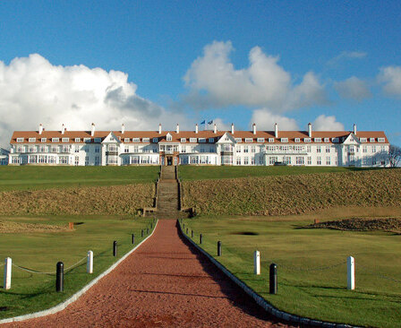
Turnberry (golf course)

Turnberry is a golf resort on the Firth of Clyde in Ayrshire, southwest Scotland. It comprises three links golf courses, a golf academy, a five-star James...

2003 Senior British Open

The 2003 Senior British Open was a senior major golf championship and the 17th Senior British Open, held from 24–27 July at Turnberry in South Ayrshire...

Nearby Amenities

Located within 500m of 55.289443,-4.8368378
Ford: yes
Lat/Long: 55.2922102/-4.8360132
Parking
Source: survey
Lat/Long: 55.2877832/-4.8326183
Parking
Parking: layby
Source: survey
Lat/Long: 55.2913793/-4.8328347
Power: pole
Lat/Long: 55.2902795/-4.8299272
Power: pole
Lat/Long: 55.2907473/-4.8311359
Description: Stile
Lat/Long: 55.2894141/-4.8326342
The data included in this document is from www.openstreetmap.org. The data is made available under ODbL.

Have you been to Dowhill Port?

Leave your review of Dowhill Port below (or comments, questions and feedback).